

rcostell
-
Posts
155 -
Joined
-
Last visited
Content Type
Profiles
Blogs
Forums
American Weather
Media Demo
Store
Gallery
Posts posted by rcostell
-
-
19 hours ago, ChescoWx said:
See answers above
Here's the thoughts on the causal mechanism. The Swiss live in concert with glaciers, rockfall and permafrost. I too, have seen these landscapes rapidly changing in places I've visited such as the Central and Northern Rockies, Austrian and Swiss Alps, Norwegian Alps, Dolomites and Iceland. The changes there are accelerating as one can readily see and in talking with the locals- you don't need a lot of data to understand what is going on. They are huge and macro in nature. I'd ask that Dyou do a little reading on glaciology and get familiar with this science before you readily use the words "nothing burger". Maybe in a small county in Pa. according to your rightly disputed charts- but to throw that opinion around conflicts with observed real life. I hope you can realize that.
-
 2
2
-
-
1 hour ago, ChescoWx said:
The extremists and climate myth believers are no doubt...displeased with the rising tide of folks who now have come to realization that climate change is of course a nothing burger.
So what is your position on Climate change- is it "Cyclical" or "a nothing burger"? Does it change? Is the larger trend warmer? No? Is there life beyond Chester County? I just got back from Valais Canton in Switzerland. I can assure you that the people who used to live in the village of Blatten, after the glacier collapse do not think that a warming climate is a "nothing burger". ...and thats a fact.
-
2 hours ago, ChescoWx said:
Meteorologist Chris Martz making headlines as a source for debunking many climate myths pushed by alarmists and extremists! Great to see the press starting to come around!!!
C'mon man. "Headlines"? " Debunking"? For God's sake- Its the New York Post (of all gospel "news"sources...) paraphrasing a 22 year old. You're embarassing yourself.
-
 1
1
-
-
12 minutes ago, rcostell said:
I 'm hoping you get confused between statistical cycles and overall trends. Like the stock market for instance. There are short term cycles up and down- but the overall actual statistics show a long term trend of upward. As it were- the overall warmth of our planet has also trended up, despite shorter term ups and downs ("cycles"). That is unequivocal, using the best data gathering tools that mankind has produced- and cannot be denied, unfortunately. I wish it were not so... Just being realistic- looking at objective evidence. No arm waving, or card carrying. I've been around the world- and seen the evidence that supports the long term trend- which is becoming evident to impartial data gathering mechanisms. The challange is how do we monitize solutions that buffer us from impending negative possibilities?
...but we digress. Not the right thread for this debate. In other news: Observation in western Camden County NJ shows a continued aversion to predicted rainfall amounts. Under the trees is still dry aafter todays rain "shield" continued to wedge apart around us. Its beyond random and seems to continue proving the adage thsat "dry begets dry". Its uncanny in how many instances this year, blobs. bands or waves of rain have avoided, split apart or otherwise dissolved as this area has been approached. Its been going on for months, seemingly- and I'm betting that our deficit in this immediate area is significantly more than other areas in the D.V. Local landscapers report on dead or dying shrubs and ornamentals that are commonplace since late last summer. Seems too repeatable to be coincidence.
-
11 minutes ago, ChescoWx said:
LOL!! nothing to weep about with what has been a simple minor warming cycle....now a card carrying alarmist may be fearful - but yours truly not so much!!
I 'm hoping you get confused between statistical cycles and overall trends. Like the stock market for instance. There are short term cycles up and down- but the overall actual statistics show a long term trend of upward. As it were- the overall warmth of our planet has also trended up, despite shorter term ups and downs ("cycles"). That is unequivocal, using the best data gathering tools that mankind has produced- and cannot be denied, unfortunately. I wish it were not so... Just being realistic- looking at objective evidence. No arm waving, or card carrying. I've been around the world- and seen the evidence that supports the long term trend- which is becoming evident to impartial data gathering mechanisms. The challange is how do we monitize solutions that buffer us from impending negative possibilities?
-
26 minutes ago, ChescoWx said:
What's old is new and that old cyclical climate change is no doubt coming back around for future generations to enjoy!! Can the cold of the 1970's be far behind us??
You'd better hope so. Here's some real data about our current "cycle". https://climate.nasa.gov/vital-signs/ice-sheets/?intent=121 Read it and weep.
-
16 minutes ago, ChescoWx said:
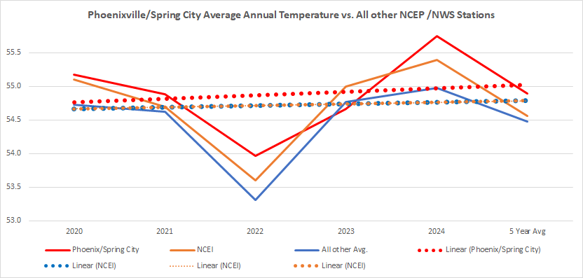
Below is the average of all other stations and of course both the alterned NCEI averages and the Phoenixville/Spring City combo are higher than the all other station averages every year with the exception of 2023. In fact in 2024 the Phoenxiville/Spring City combo was higher than every other reporting stations average temperature.
I only drop into this forum to read and learn a bit about others data and opinions on Climate Change. I know I've asked before (and folks have migrated over there at the time of asking..) - and don't mean to be "crank"...but could you two or three folks engaged in the running "Chester County data bickering" PLEASE remember that a thread was created for that purpose- and take the tit-for-tat dicsussion and parsing over there. The squabbling of that subject, in this forum is in the wrong place again. I'm hoping for continuity to keep the thread interesting as a read and with some modicum of alignment with its title. Obliged.
-
1
-
-
45 minutes ago, ChescoWx said:
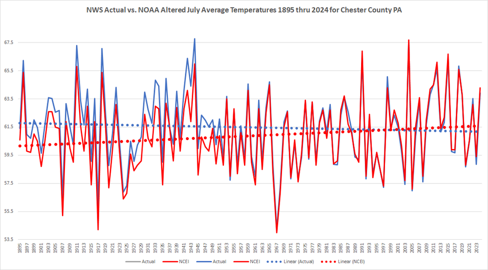
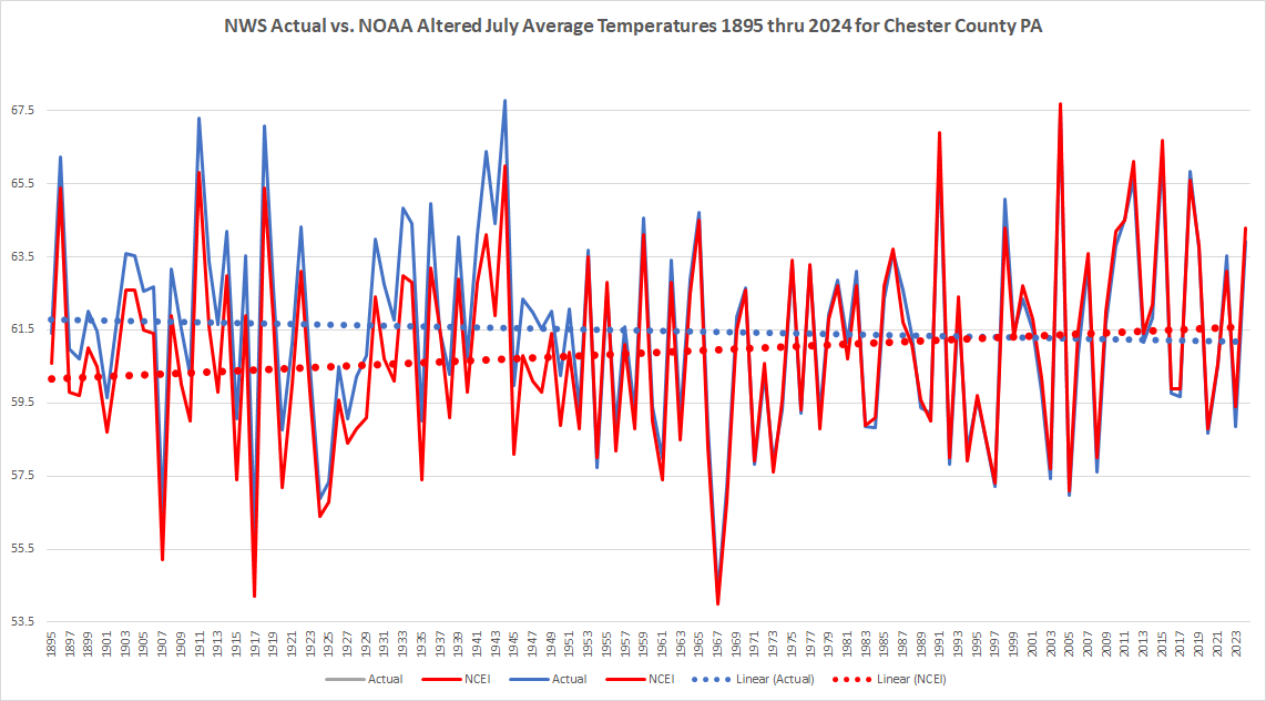
ClimateChanger not looking hard enough! Let's take a peek at July since you bring that month up!! Welp = even more egregious altered data in July. NCEI chilled a whopping 74 of the 76 years between 1895 and 1970....and of course have now turned around and warmed 46 of the last 54 years from 1971 thru 2024. And my oh my what a difference these little alterations make to the climate story of Chester County PA!! Red is the altered....look at that warming - but where the heck did it go without those wee little adjustments??? We are actually cooling in July!!!
Yet another Chester County bicker session in the wrong thread. Seems futile to object?
-
Observation: The repeated underperformance of rainfall amounts in our part (western Camden County) of SNJ has been notable. Amounts from the last several events to the west and in some cases to the east on the coastal plain have been significantly higher. Soil moisture and vegetation are continuing to suffer. Last 2 days have featured minimal rain- not enough to wet under the trees and radar looks to be winding doiwn rapidly from this event, Dry begets dry it seems.
-
1
-
-
2 hours ago, tamarack said:
The Scouts rented from Rands! I'm sure they had modernized prior to Sandy - those exposed driveshafts would've had to go. My dad, older brother and I also went down there a couple times, too. We learned about greenheads the hard way. We'd come in about when the sea breeze quit and would have hands covered in fish guts while those demons took advantage of the calm.
You know it about the greenheads! Blackflies are really annoying- but greenheads just plain hurt! Those marshes with the wind down can be tough, agreed. Great Bay was a great fishing bay- 10 pound weakfish were not unknown...good waterfowl hunting, too. The Baymens museum in Tuckerton is a great stop, if you've never seen it.
-
1
-
-
1 hour ago, tamarack said:
I grew up in northern Morris County and was 17 at that fire's date. The following super-dry and warm October, a fire on state land covered ~3,000 acres and persisted thru October and into November. The land was mostly loose rockpiles and the fire would follow roots under the stuff, often popping up behind the firefighters. The fire was only 3-4 miles from my HS, and each morning we'd look north to see where the smoke was most dense that day.
Our grandkids live in Gloucester County farm country, a few miles west (thankfully) of the barrens.Southern Maine has a limited but significant acreage in pitch pine barrens. The climate is booth cooler (natch) and wetter than NJ and the soils, though not especially fertile, are a lot better was well. Therefore, the pines tend to be taller and crown fires in Maine barrens very rarely reach the crowns; frequent ground fires have sustained the ecotype, though the State Tree, Eastern white pine, is a problematic invasive there.
Theres a section of pine barrens up near my place in the Northern Adirondacks in Clinton County. Odd seeing that landscape up there...
-
1 minute ago, tamarack said:
When I was in scouting - late '50s - we stayed in Tuckerton at a camping place called Chip's Folly (and caught fluke and blowfish in Great Bay). The camp was next to an Atlantic white cedar swamp, with water that looked like very dark tea. I've since read that cedar logs from 1,000 years ago have been dredged from similar bogs and in totally sound condition, being "pickled" for a millennium.
Yep- Have camped there myself. We used to cannonball off the top of the counterbalance on the draw bridge over the Mullica River (flows into Great Bay) at night, that cedar water stayed cool all year around. Used to have a boat in Great Bay at a place called Rands marina, out on "7 bridges road". Sandy erased Rands from the map- not rebuilt. (Sold my boat prior). Cedar swamp "logging" is still practiced some- down near Delaware bay in Cumberland County. Some of those logs are "prehistoric" huge! I've also read that the Meadowlands up near where you grew up contained large Atlantic White Cedar stands. Some tiny replanting attempts are ongoing. Those swamps make great flood control measures- but BOY are they dark at night!
-
8 minutes ago, tamarack said:
I grew up in northern Morris County and was 17 at that fire's date. The following super-dry and warm October, a fire on state land covered ~3,000 acres and persisted thru October and into November. The land was mostly loose rockpiles and the fire would follow roots under the stuff, often popping up behind the firefighters. The fire was only 3-4 miles from my HS, and each morning we'd look north to see where the smoke was most dense that day.
Our grandkids live in Gloucester County farm country, a few miles west (thankfully) of the barrens.I'm not too far from there, actually. Just 3 years ago (again, in April) there was a Pinelands fire that burned almost 70,000 acres. I've read that the "cedar water" prevalent in the area (high acid tannin from all the Atlantic White cedars leaches into the water) retards the leaf litter from decomposing quickly- hence high tinder availability. Sea captains in Colonial times used to cask that cedar water for drinking aboard- as it would not "sour" quickly. You can still drink from cedar water springs in certain areas- as all waters emanating from the central Pines do not flow through man made pollutants. Sorry to go on. I love that area!
-
1
-
-
29 minutes ago, tamarack said:
Maybe look up April 20, 1963.
The pine barrens are a fire ecotype, as the infertile sandy soil supports a pine-oak forest that's sustained by fire. Unlike most conifers, pitch pine can produce sprouts after the above-ground trees are burned, allowing the post-fire forest to remain much the same. Also, that infertility leads to late leaf out and slow decay of litter. As noted, central NJ gets more than twice the SoCal rain, but the excessively drained soil dries quickly.That was a crazy one (I was 5, but recall it vaguely in family discussion) in an area that gets many. That sandy soil drains so fast (and can be tough in spots to traverse ("sugar sand"!) but sits on the largest untapped aquifer east of the Mississippi! Its a unique, large area of the southern/central part of the State that is surprisingly (except at the edges, filling in) unpopulated. Radiates well in cold clear conditions, too. It can be 20 degrees here but 0 30 miles southeast, in the heart of the pines. Cool stuff!
-
 1
1
-
-
2 hours ago, Albedoman said:
Your italicized comments were not necessary- only to add insult to your previous remarks. I am sorry feel this way. You seem to have a pattern of doing this on other forums too. Anyway you stated the NJ fire was contained in NJ- you could not be more wrong see link below this morning. As far as as fires in the NJ pine barrens as a necessary part of ecology- the Pine Barrens does NOT have the same climate regime as S California. I lived in S. California for ten years and personally dealt with my own brush wildfires. If it they did have the same yearly climatology, S NJ EMS would be better prepared for such a major fire as the one today. Most likely this fire was caused by some knucklehead burning winter debris and not by natural causes like lightning. The Pine Barrens also do not have highly flammable chaparral type vegetation with 18 in of rain per year, just dense evergreen trees and typical underbrush found in our area with 40 in of rain a year. Large wild fires are not normal.
Sir- I believe in a written, science/factual based forum like this one- thats its a good thing to call out personal blaming, factual inaccuracies or slander. If you 've seen a pattern of that- Thank you. I don't cotton up to BS. But there you go again- for the Ocean county fire, I used the word "contained" deliberately- as its latest given offical status was "30% contained". Thats not "Out of Control" (nor certainly out, either!) Good for you for observing that Southern California has a different weather pattern, climate and vegetation than the NJ Pine Barrens- I'm familiar as I spend lots of time in San Diego county- but have no idea why you brought that area into the dicussion. Fires )of all sizes) in the Pine Barrens are relatively common this time of year- not every year- and a part of the local ecology, and always have been, prior to the era of suppression. (Lots of scrub Oak leaf litter, pine needles and very sandy, porus soil make for a dry, fuel rich area- you can ask others who live here, or maybe Mr. Gorse, if you distrust me. I'm done so, you can get the last word in, if you'd like- as that seems important to you.
-
10 hours ago, Albedoman said:
After being criticized by an individual for not taking a chill pill and for saying the mulch fire was major fire and that I was blowing the fire possibilities out of proportion with the current drought in the last few days, two so called non-major wildfires are still going crazy. Jim Thorpe area over 500 acres and now another non major fire in southern NJ. All I hear now is crickets at my house.
Also Mike Gorse, I must apologize to you and your staff as I did not mean any disrespect toward you or your staff at MT Holly. I am really frustrated with this crappy weather pattern we are stuck in for the past 9 months and did not mean to take it out toward MT Holly staff. Many of the old weather hobbyists have to be as frustrated as I am too as these daily 20-30 mph Santa Ana type winds with extreme diurnal temp ranges and no Gulf of America moisture source for storm convection which has basically has been gone for nearly a year now. I am also hoping a special weather statement will be issued that considers the under-stories in the woods and nearby brushy fields are extremely dry right now regardless of any rain we received two weeks ago. The dry warm winds are sure not helping as evident by these fires. Thanks
https://www.foxweather.com/extreme-weather/jones-road-wildfire-new-jersey-shore-smoke-evacuations
https://www.inquirer.com/news/pennsylvania/jim-thorpe-pennsylvania-wildfire-20250422.html
Good morning. You can call me Bob. I'm happy you apologized to Mr. Gorse for your remarks. Well deserved. That was the point of my comment that the mulch fire was not "major"- and especially that exaggeration of a fire caused by spontaneous combustion shouldn't be linked to NWS being negligent. Those were my only points. I see nowhere where I wrote those other things you linked me to.
(As far as your attempts at "face- saving", above- everyone on this board knows we have a rainfall deficit, its been windy, and its fire season. I mentioned none of that- so don't imply I did. The fire near Jim Thorpe was preexisting my comments- and the Ocean County fire is "major", although contained. I grew up in the Pine Barrens- there are fires most years, especially during spring before leaf-out..its a neccessary part of the ecology here. Your proclivity towards exaggeration and blaming folks for non-existent issues is noted. Maybe stop trying to bite my ankles when you are already on the canvas. Its a bad look.)
-
9 hours ago, Mikeymac5306 said:
I can back him on this as a firefighter. While maybe not a "major" fire. It is quite a nuisance and a burden on the volunteers who have to sacrifice their day just to babysit it and keep dumping water on it.
I agree with you 100% of course. My point was that the situation was being exaggerated and (non-drought) causal mechanism ignored- at the expense of our local NWS mets- who have enough "static" to deal with these days.
-
2
-
-
3 hours ago, Albedoman said:
When the mulch pile serves 35000+ residents and takes out a fire company for a few days, yes it is a mafor fire issue for a volunteer fire company and the municipality
Mlulch can spontaneously combust- which the local firefighters say is what happened at that site. Its been smoldering for weeks. Nothing to do with NWS or weather, at all. Roger that?
-
3 hours ago, Albedoman said:
When the mulch pile serves 35000+ residents and takes out a fire company for a few days, yes it is a mafor fire issue for a volunteer fire company and the municipality
Weren't you the same guy on here that said "mark my words" there was going to be major ice jam issues on the Lehigh this year? Maybe take a bit of a chill pill instead of disrespecting NWS Mets. Just a suggestion.
-
 1
1
-
-
3 hours ago, Albedoman said:
C'mon MT Holly wake up. Here is another major fire this morning in Lower Macungie. Township mulch pile on fire.

A smoking mulch bed is a "major fire"? Really?
-
20 hours ago, BBasile said:
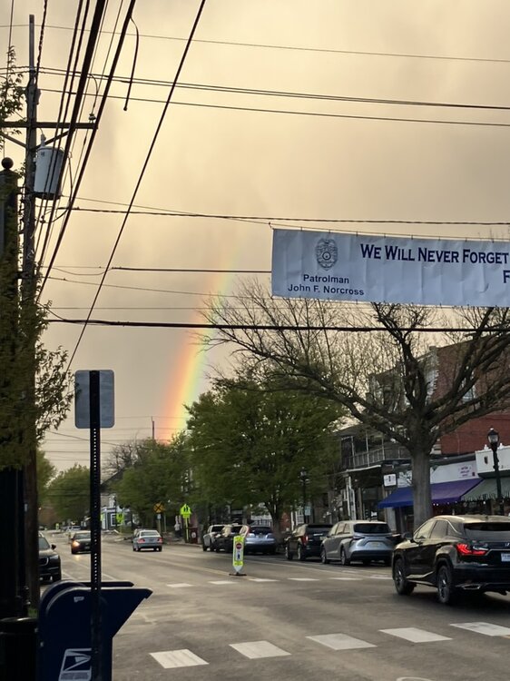
Philly skyline and the storm that just brought all that wind to the Phillies' game.
.thumb.jpg.b73a65aae3bdf94d57e968c90ec8b024.jpg)
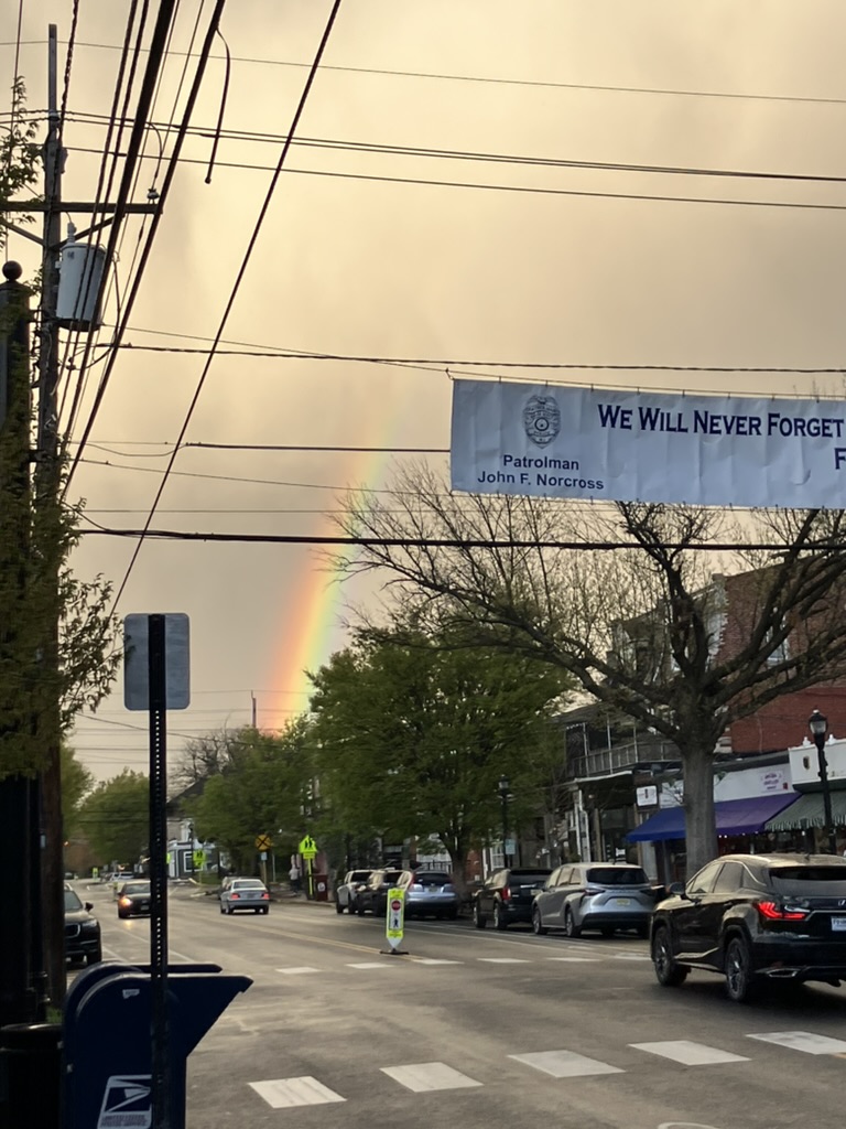
Great Shot! Below is closer to the storm, last evening about 7 PM in Haddon Heights. Just got clipped with about 1 minute of rain from that curtain seen in your image..
-
2
-
1
-
-
13 minutes ago, Baroclinic Zone said:
Sweet.. Massive view! Will be in Zermatt again this September and might hit it up. Heres a link to Chez Vrony. Its off the Sunnega lift.
https://chezvrony.ch/wordpress/en/
-
1
-
-
1 hour ago, Baroclinic Zone said:
Not kidding. The views are spectacular. I was up on top of Zermatt in August. Beer and food was spectacular. I sat outside at mid-mountain with views of Matterhorn in front of me.
Chez Vrony? (what a place!)
-
9 minutes ago, powderfreak said:
I do not believe this. If it was just about the money, folks would accept the science. People don’t accept the science.
Some folks don't- agree with you. Even in this forum, science based that its' nature is- there are degrees of non-acceptance- lots of distractions. Its the decison makers or disrupters that really count in the long run.
Occasional Thoughts on Climate Change
in Climate Change
Posted
To amplify further- coincidentally, this mutinational (10 nations, many scientists) study just released details the rapidly declining glacial trend and causal mechanisms. Effects of this trend alone will be significant to the human populace near or dependant on glaciers or the bodies of water they drain into- including the Oceans.
https://www.uaf.edu/news/study-finds-alaska-rest-of-earth-to-lose-most-of-glacier-mass.php