

Duca892
-
Posts
151 -
Joined
-
Last visited
Content Type
Profiles
Blogs
Forums
American Weather
Media Demo
Store
Gallery
Posts posted by Duca892
-
-
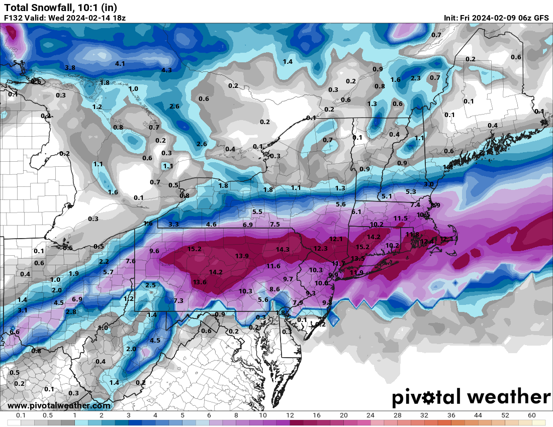
Bernie Rayno woke up and is still sticking to his guns for SEPA with no changes in his forecast. Going to be fascinating what ends up happening with this one.
-
Hoping like hell I wake up to this trend having stuck and a Winter Storm Warning for Bethlehem
-
I’ll say this I’m not trying to get tooo excited but I’m starting to see Mets acknowledge the seeming SE trend on Twitter
-
So like…. Is the biblical pattern change still happening orrr
-
 1
1
-
-
4 minutes ago, ChescoWx said:
Bernie Rayno is where I would put my faith it with this one "The big snows over 6+ are northern PA into southern New England, where the injection arrives Sunday night into Monday. Near I-80 in central PA to NePa and NW NJ likely a 3-6. 1-3 from Harrisburg to Allentown & northern NJ northwest of NYC. Mostly rain SE PA"
Bernie’s been pretty spot on this entire storm as far as the eventual North trend. Kudos to him so far
-
 1
1
-
-
11 hours ago, Duca892 said:
We are like only 30hrs away from honest to god Winter Storm Watches being issued for here in the Lehigh Valley and I can’t remember the last time we went from the beautiful progression of a Watch to a Warning. Begging this hold. Will lovingly take a nice 4-8in
Go to work for 7hrs and walk out to a Northern Trend

-
We are like only 30hrs away from honest to god Winter Storm Watches being issued for here in the Lehigh Valley and I can’t remember the last time we went from the beautiful progression of a Watch to a Warning. Begging this hold. Will lovingly take a nice 4-8in
-
1
-
-
Bernie Rayno on Accuweather was pretty spot on with his thoughts last night/today that we would see a northern trend. Was hoping for Warning Critera, but will gladly take another 2-4in snowfall if this is what it ends up being.
-
12z GFS might of inched north a bit but looks like it held serve for LV North? idk. all i see are colors
-
2 minutes ago, Franklin0529 said:
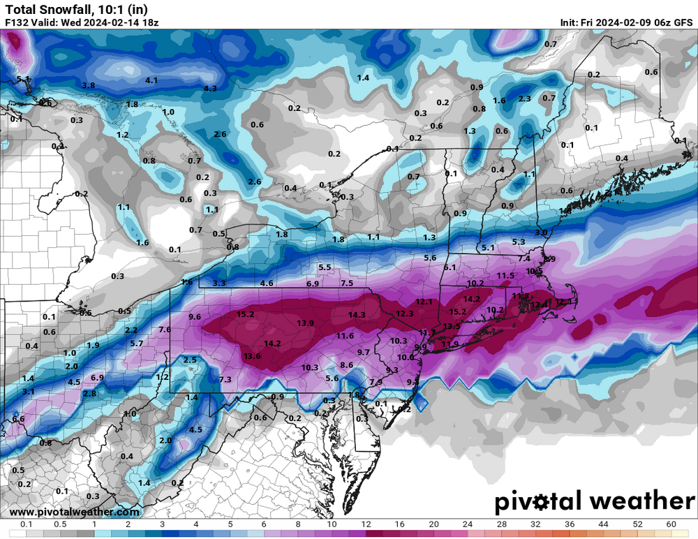
Thank You much. Will be interested to see if this takes the jog North like our trends like to usually do today. I mean it really won’t take a lot to going from a nice 5-8in snowfall in the LV to nothing. Hoping this hold serve. Thanks again.
-
1
-
-
Any idea if the 6z GFS held?
-
1
-
-
Hey... i would gladly take another 3-5in snowfall for what the GFS keeps selling in the Lehigh Valley
-
7 hours ago, Duca892 said:
Hi please sign me up for the Day 9 Valentines Day bomb the 0z GFS spit out
This went from a bomb snowstorm to cutting through the middle of PA to being now I think surpressed. I always love run to run changes lol
-
Hi please sign me up for the Day 9 Valentines Day bomb the 0z GFS spit out
-
1
-
 1
1
-
-
Can I ask a really novice question? Everyone’s hyping up this pattern change, but when will that be reflected with storm chances in the LR? It just looks rainy and warm?
-
1
-
-
Not sure I remember a time period in winter as quite hyped up as people have made Mid-End February
-
Not hardcore watching Sunday into Monday, but that would be a pretty awesome surprise
-
Would be epic if anything else would on to support the EURO for this weekend
-
16 hours ago, Ralph Wiggum said:
GEFS and GEPS and EPS to a degree all have a small window around the 29th with a system tracking under us. Problem is antecedent airmass may not be too favorable. CMC and GFS op are close to something. Looks like a spring storm with higher elevations favored.
Looking out into fantasy land, weird to keep seeing something consistently popping up on the super extended stuff centered around Presidents Day. Big ones sniffed out early
 ?
?
As if right on Que the 6z GFS pops a weird looking storm that hits us with some snow but demolished up north around the exact same time frame
-
I am an absolute no nothing, but it looks like you can kind of walk away from model watching for the next 7-10 days before scoping out what is possible in February. Looks warm and rainy.
-
Hope these South shifts stop. Was looking forward to a nice 4in
-
1
-
-
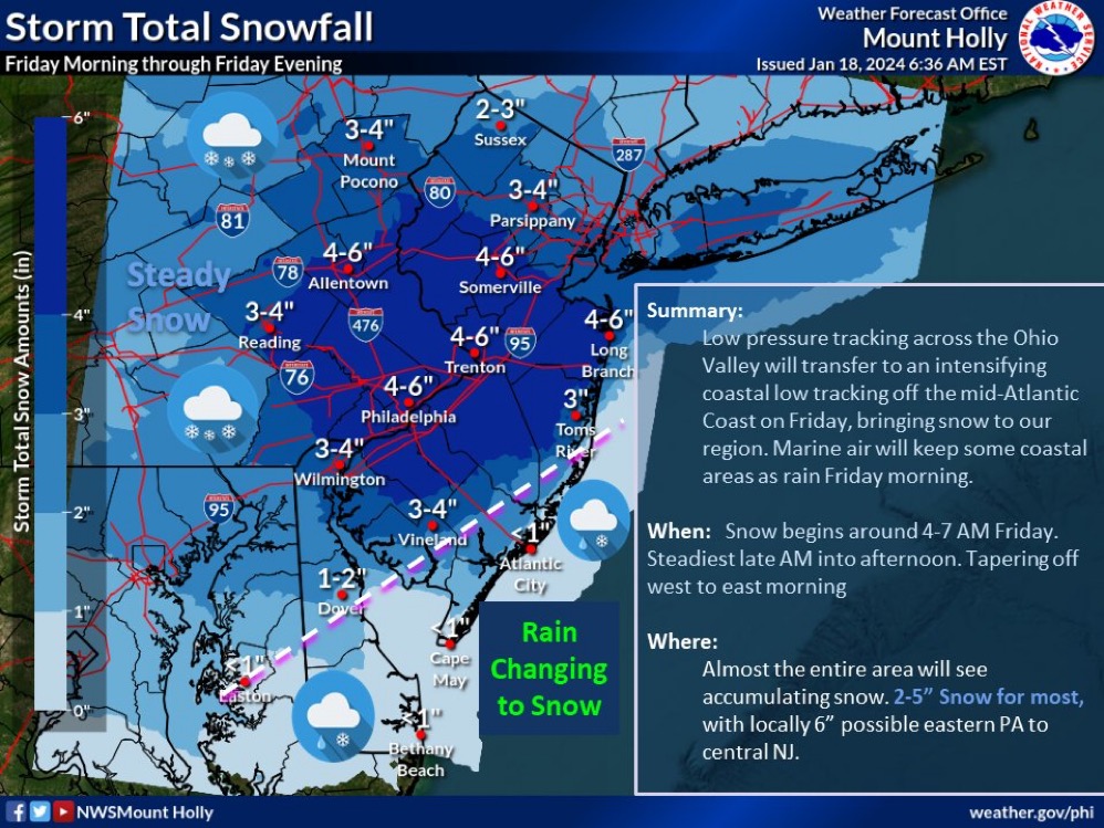
My. Holly going for 4-6in for a pretty large area
-
1
-
-
Looks like another solid 2-4in event here in Bethlehem. Take that in a heartbeat
-
1
-
-
Mt. Holly bumping totals to 3-4in for Allentown off their latest update. Anxiously hoping for a message from work telling me to WFH on Tuesday
-
3
-
1
-
E PA/NJ/DE Winter 2023-2024 OBS/Discussion
in Philadelphia Region
Posted
Would have to think at this point NWS is going to wait to see if things hold serve at 12z and then move to issuing Winter Storm Warnings in around the Lehigh Valley for what I will assume to be a general 4-8in