

NJsnow89
-
Posts
240 -
Joined
-
Last visited
Content Type
Profiles
Blogs
Forums
American Weather
Media Demo
Store
Gallery
Posts posted by NJsnow89
-
-
1 minute ago, NJwx85 said:
That 4.8" in one hour is going to be crazy. The best dynamics are always just NW of the rain/snow line.
Hey man, do you think this trends South any? Getting worried about the euro run
-
Just now, MJO812 said:
Its amazing how everyone was saying how this storm can't come north because of the confluence and here we are , models are coming north.
Yeah and we are running out of time now. Oh well. Always next time
-
Just now, SnoSki14 said:
The storm is likely going to correct south soon. The high is too powerful to the north. A gfs/euro compromise is most likely.
It’s possible but hard to go against all the models except gfs
-
Just now, NJwx85 said:
Why do people still look at the GFS for coastal storms?
Gfs is the furthest south of any model. Ukie looks to be amped
-
Just now, SnoSki14 said:
Ukie looks in line with other models.
Agreed. Our area is looking like a sweet spot.
-
2 minutes ago, Rjay said:
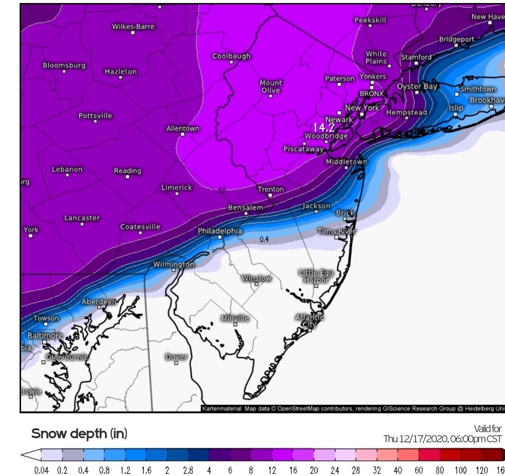
For the weens

Nice! First time ever I see my town name (Piscataway) on a snow map lol.
-
 1
1
-
-
11 minutes ago, wizard021 said:
Ukmet is less amped than the cmc , closer to the gfs but not the same. Would bring in more snow for our area.
You have maps?
-
All players are on the field now so it’s possible we may see more changes
-
-
1 minute ago, Allsnow said:
The northern cutoff of precipitation is going to be heart breaking in this event
Agreed. Hopefully the cutoff is not anywhere near the NYC metro area.
-
1
-
-
4 minutes ago, sferic said:
18Z ICON Catskills blockbuster
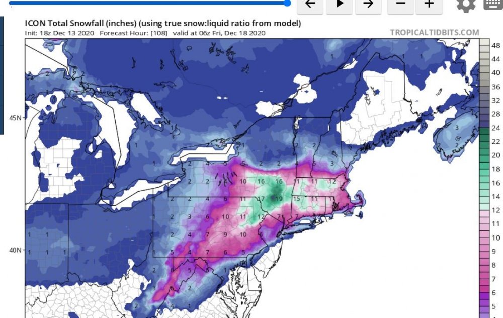
Yup. Icon trended NW from its last run
-
 1
1
-
-
Gefs way southeast. I guess that’s a risk as well
-
5 minutes ago, NEG NAO said:
wrong about what ?
It’s handling of the shortwave. He thinks the northwest trend was Bs
-
6 minutes ago, jdj5211 said:
Bernie Rayno going 12-18 NNJ/NYC area....
He might bust if the latest trends are correct
-
2
-
 1
1
-
-
Euro ensembles has a lot of tucked in members.
-
1 minute ago, friedmators said:
Lebanon.
.Nice! I think you are in a perfect spot for this storm. I am about 25 miles east of you in South Plainfield NJ
-
1 minute ago, friedmators said:
I am at the 78/287 intersection in NJ. I can’t remember the last time I didn’t have BL/ML concerns. 6 or 26” I really don’t want to be a 850 line jockey for once.
.What town are you from?
-
1 minute ago, wdrag said:
Not sure of the impact... but the 06z EPS members for 12z/17 .. not quite as intense a storm but many members in the NYC bight. We may know more in 24 hours. May mean slightly less qpf near the storm center, and also more option of ice/rain up to I80?? I don't know.

Wow. Those members came way west. Mixing issues
-
1
-
-
1 minute ago, jm1220 said:
With confluence like that and a huge arctic high, to me it can only trend north so far. If the high and confluence weaken that's another story. Verbatim I think there would be a very sharp cutoff between big snow and little because of the resulting dry air.
Thank you! Also, with confluence pressing down more each run, wouldn’t that trend this further south if anything?
-
Quick question- don’t these types of storms usually trend north in time? Worried about the last min north trend which may warm us up.
-
7 minutes ago, Ericjcrash said:
Gfs is a whiff...
Less amplified trend in recent runs
-
 2
2
-
-
5 minutes ago, NEG NAO said:

Less amplified which means not a strong storm for our area.
-
We have been burned many times. Not getting my hopes up at all until we are 48 hours away.
-
1
-
-
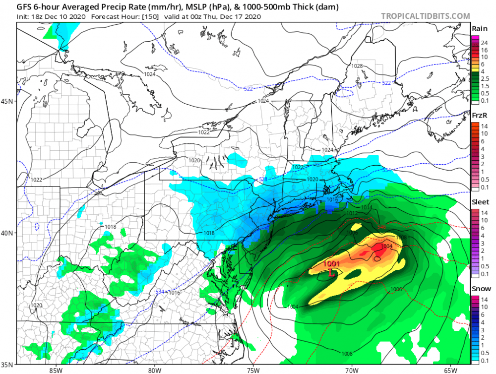
Mainly a rain threat. Not sure what everyone is seeing.


Major Nor'easter snow storm (possible top 20) Noon Wednesday-Noon Thursday Dec 16-17, 2020
in New York City Metro
Posted
Appreciate it. I live near Edison. Getting worried about the north trends