

STxVortex
-
Posts
196 -
Joined
-
Last visited
Content Type
Profiles
Blogs
Forums
American Weather
Media Demo
Store
Gallery
Posts posted by STxVortex
-
-
31 minutes ago, Hurricane Agnes said:
Plus it's shallow along the coast too. I remember being in Galveston around this time of year about 25 years ago and the "monotonous" forecast of "Partly cloudy, high 95. Tomorrow, partly sunny, high 96"... Thursday, mostly sunny, high 96".... and the 85 degree water.

Nothing has changed, same forecast all the time, 90deg+ highs, 77-85 lows, offshore SST's 81-86deg, inshore higher. Most stations-of-record have recorded 90deg+ temps every day for 90+ days this summer.
This is what Imelda, possibly Karen and/or a potential Melissa has to feed on, 27-31degC GOM bathwater:
-
18 minutes ago, Hurricane Agnes said:
Imelda was sitting in literal sauna water and am guessing the intensification was enough to give it enough momentum to finally move onto land. It will be interesting to see where Karen actually makes landfall given where they just found the eye (or at least one area where that is part of an eye).
Indeed, 'sauna water'! As a surfer and sailor around South Padre [on that radar image, due east of Brownsville], water temps in the upper 80deg/lower90's, plus sun, with exertion would get you overheated. We [kids too] swam the very warm and saline Laguna Madre, the GOM surf, and would sail offshore 10-15 miles to swim the warm open bluewater. Until I hooked my first Great White shark... :] a young one, only about 7-8 feet long, she had beautiful dentition ^^^^. :]] If she's still out there, she's probably 16'+ now.
-
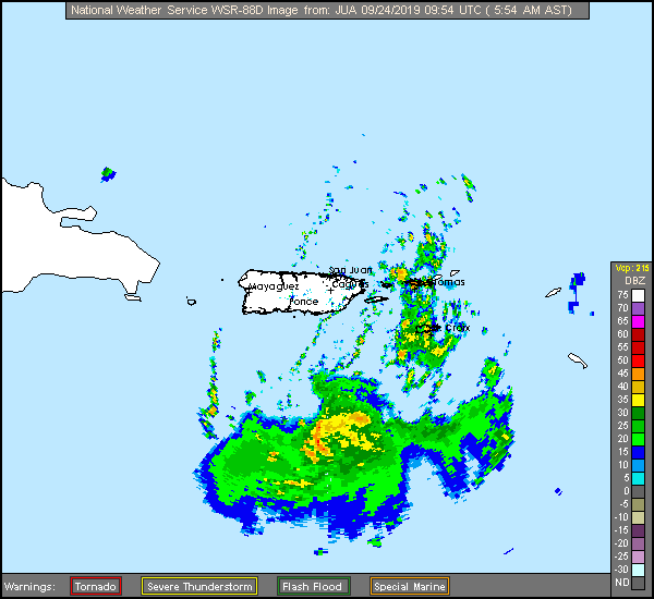
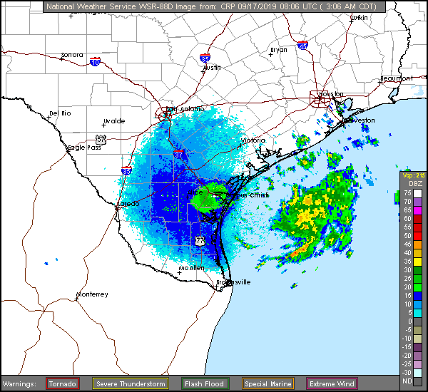
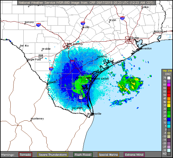
Just for chuckles, here's a comparison of the NOAA WSR-88D radar long range base reflectivity scans of the proto-TS Imelda and the current TS Karen. The scans are from the CRP and JUA WFO's, IIRC the LR radar image scan diameter is ~500 miles.
Note that the well-formed Imelda image is from about 11 hours before it's 'official' TS designation, but it wasn't being closely monitored att [surrounding gauges indicated baro falls and circulating windfield].
Imelda looked the part, but only brought an eventful rainfall and not much wind. If Karen eventually gets to the GOM it might be another major in all parameters.
Pre-TS Imelda
TS Karen
-
NHC is now mentioning a "Disturbance 1" near the northeastern tip of Yucatan, it has a 10%/2day-20%/5day chance of becoming TD Melissa or 100L. I'd bet that this is the same wave that had been appearing on the earlier forecasts to the ESE of Jamaica and was dropped a couple days ago.
Looks to be headed for Veracruz or Tampico, MX, but I'll just get a little nervous anyway :] .
Anything around the very warm Bay of Campeche at this time of year has a chance of cooking off.
ZCZC MIATWOAT ALL
TTAA00 KNHC DDHHMM

Tropical Weather Outlook
NWS National Hurricane Center Miami FL
200 PM EDT Mon Sep 23 2019

For the North Atlantic...Caribbean Sea and the Gulf of Mexico:

The National Hurricane Center is issuing advisories on Tropical
Storm Jerry, located several hundred miles southwest of Bermuda, on
Tropical Storm Karen, located over the eastern Caribbean Sea, and
recently upgraded Tropical Storm Lorenzo located several hundred
miles south of the Cabo Verde Islands.

1. A broad and elongated area of low pressure is located near the
northeast tip of the Yucatan peninsula. This system is currently
producing disorganized showers and thunderstorms over the southeast
Gulf of Mexico. Some gradual development of the disturbance is
possible while it moves slowly westward across the southwestern Gulf
of Mexico during the next several days before it reaches the
northeast coast of Mexico late Friday or Saturday.
* Formation chance through 48 hours...low...10 percent.
* Formation chance through 5 days...low...20 percent.

Public Advisories on Tropical Storm Lorenzo are issued under
WMO header WTNT33 KNHC and under AWIPS header MIATCPAT3.
Forecast/Advisories on Tropical Storm Lorenzo are issued under
WMO header WTNT23 KNHC and under AWIPS header MIATCMAT3.

Forecaster Zelinsk
-
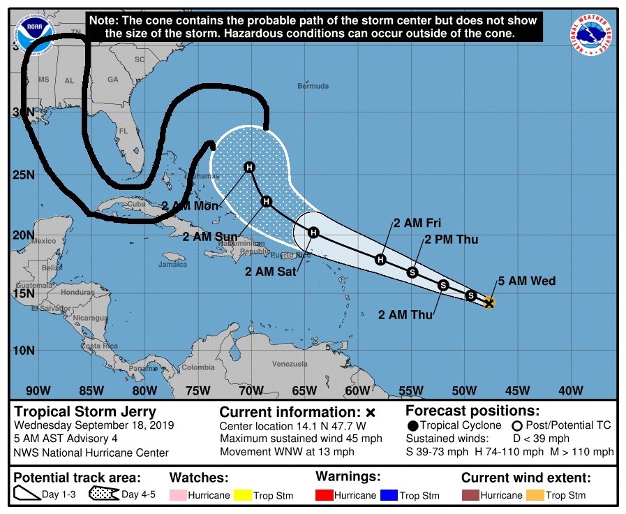
Ruh-Oh... Alabama, we gots a problem :
[Note, FYI, below TS Jerry potential track image, black sharpie extension, has been modified, altered, is fake news. Not to be used for planning decisions, honest... /s]
-
 1
1
-
 4
4
-
-
Another very respected scientist and leader stands up for the good people of NOAA, and [too, imo] politely excoriates the incompetent, and sycophantic, who cravenly interfere with the scientists and technicians of NOAA.
From the "Scientific American" * :
Observations - Leadership In The Age Of The Surreal
"Leadership in the Age of the Surreal
The professionals at the National Weather Service deserve political leadership that will stand up for them—even when that puts the leaders’ own jobs in jeopardy.
.Over the past two weeks, Hurricane Dorian destroyed portions of the Bahamas and posed a major threat to the southeastern U.S., before eventually making landfall in North Carolina. Given that we are in peak hurricane season, this is not an unprecedented story. In today’s age, however, the devastating hurricane became a backdrop to a political farce that, even in retrospect, seems unbelievable.... [read the whole article at the link]
ABOUT THE AUTHOR(S)
David Titley
David Titley is an affiliate professor of meteorology at Penn State University; Rear Admiral, U.S. Navy (retired); former oceanographer of the navy; former Chief Operating Officer for the National Oceanic and Atmospheric Administration; and a member of the Governing Board at the Center for Climate and Security.[ * The "Scientific American", I began subscribing to it ~c. 1968 ]
-
3 hours ago, TriPol said:
I'm answering my own question. https://www.sciencemag.org/news/2012/01/why-noaa-commerce-department
We should create a cabinet level department that houses Climatology, Geology and Meteorology and move NOAA and the USGS there and create some kind of new organization that deals with climate change.
No rational, logical, science-related or based US government policies will be possible until the place is cleaned up, reformed, until the 'swamp' is truly drained out.
It's currently mostly controlled by and for anti-science, anti-factual, cultist grifters who act on a far different plane than a patriotic 'for the good of the nation' basis; when not acting on behalf of foreign interests [like RU, MbS, DPRK, etc].
-
2
-
-
29 minutes ago, cheese007 said:
"The party told you to reject the evidence of your eyes and ears. It was their final, most essential command."
An apt quote, but you should attribute it to George Orwell's great [and scary] book, "1984", which I think too few today are aware of. Yet, here we are, nearly living in it.
Nineteen Eighty-Four: A Novel, often published as "1984"
“What you’re seeing and what you’re reading is not what’s happening”
-
2
-
-
The American Meteorological Society, the 'pro mets' professional group, issued a statement of support for the working NOAA staff [below]; especially those of the Birmingham, AL WFO, who corrected the 'Met-in-Chief's' absurd Sharpie forecast and his subsequent doubling down on Sharpiegate.
The NOAA upper level management and spokesperson types who folded under that wholly unjustified and corrupt WH political pressure, with that unattributed public rebuke of the Birmingham WFO, should be instantly removed, no later than on 22 Jan 2021.
IIRC, NOAA still only has an 'acting' director, not a permanent one, yet another example of the gross negligence of this maladministration [and subservience to VP/RU]. "Only the Best"...
https://www.ametsoc.org/index.cfm/ams/about-ams/response-to-noaa-statement/
https://www.ametsoc.org/index.cfm/ams/
"Response to NOAA Statement
The American Meteorological Society fully supports our colleagues at NOAA, who consistently put the safety of the American public first and foremost. They work tirelessly employing state of the art science to keep Americans safe. With respect to the press release that was issued by NOAA on Friday, 6 September, regarding the forecast of Hurricane Dorian, AMS believes the criticism of the Birmingham forecast office is unwarranted; rather they should have been commended for their quick action based on science in clearly communicating the lack of threat to the citizens of Alabama.-
8
-
-
Anybody know what the turning radius of a 280 mile wide, 70,000ft high, multi-billion ton, 185-220mph, spinning mass of water, water vapor [and some debris] might be?
Anxious Floridians and EC'ers would like to know.Pls reply: Box DUG, Cheyenne Mountain, CO.
Not your grandmum's Buick at all.
-
TS Chantal is aliiive... fairly odd to have formation so far north [40N], but she's supposed to bend south into warmer SST, but more unfavorable atmo layers, at least for a while, then...
000
WTNT44 KNHC 210232
TCDAT4

Tropical Storm Chantal Discussion Number   1
NWS National Hurricane Center Miami FL       AL042019
1100 PM AST Tue Aug 20 2019

Recent scatterometer wind data and passive microwave satellite
images indicate that the small low pressure system that the NHC has
been monitoring for the past few days has developed a well-defined
surface wind circulation and contains tropical-storm-force winds
south of the cyclone's center. Therefore, the low has become
Tropical Storm Chantal.

The initial motion estimate is 085/19 kt. NHC model guidance is in
excellent agreement that Chantal will move eastward around the
northern periphery of the Bermuda-Azores high and gradually slow
down during the next 48 hours. Thereafter, the cyclone is forecast
to drop southward around the eastern portion of the ridge, possibly
stalling over warmer waters. The NHC forecast track lies close to
the consensus models HCCA and TVCN.

Chantal is expected to remain in a moderate southwesterly to
westerly vertical wind shear regime for the next 48 hours or so,
followed by a significant decrease in the shear through 120 h. After
48 hours, the southward motion is also expected to move Chantal over
warmer water with SSTs around 27C. However, mid-level moisture is
expected to be quite sparse with humidity values forecast to be less
than 40 percent based on the GFS and ECMWF SHIPS intensity guidance.
Therefore, little or no significant intensification is expected
throughout the forecast period, and the official intensity forecast
closely follows a blend of the HCCA and IVCN consensus models.
Although the official forecast calls for Chantal to remain a
tropical cyclone through the 120 h, the abundance of dry air that
the cyclone will be moving through could result in erosion of the
deep convection sooner than currently expected.

FORECAST POSITIONS AND MAX WINDS

INIT  21/0300Z 40.2N  56.2W   35 KT  40 MPH
 12H  21/1200Z 40.3N  52.6W   35 KT  40 MPH
 24H  22/0000Z 40.2N  48.5W   35 KT  40 MPH
 36H  22/1200Z 39.0N  44.7W   35 KT  40 MPH
 48H  23/0000Z 37.4N  42.3W   35 KT  40 MPH
 72H  24/0000Z 34.9N  42.5W   35 KT  40 MPH
 96H  25/0000Z 34.6N  44.8W   35 KT  40 MPH
120H  26/0000Z 36.0N  44.8W   35 KT  40 MPH
Hurricane Harvey Third Anniversary
in Tropical Headquarters
Posted
Today, 24 August 2020, marks the time three years ago when Hurricane Harvey began an RI in the Gulf of Mexico, as TS Laura appears ready to do shortly this evening.
Harvey, in his Texas impacts, was actually two very different behaving storms.
The initial fierce destructive high Cat 4 landfall on San Jose Island and the Rockport, TX area, then an inland excursion of about 80-90 miles NNE, with a loop-de-loop and subsequent ESE track back out to the GOM was one devastating event. The second event had a much different effect, with Harvey's further Gulf tracking and landfall east of Galveston and Houston in LA, which dumped billions of tons of rainfall, up to five feet in places, but had little wind. It all added up to the US's second most costly 'cane.
Y'all maybe contrast and compare Laura with Harvey.
I'll put a few links and images below. I'll try [later] to also add a few personal photos taken just before Harvey blasted into my homeport of Rockport. I got out in the last safe few hours, after securing my boat in it's slip and scooting for my inland home, which Harvey got real close to following me. Along with a few post-storm pics from various sources. This is difficult as my internet sucks. [hope I can edit later]
References ---
Corpus Christi, TX > Major Hurricane Harvey - August 25-29, 2017 [comprehensive report]:
https://www.weather.gov/crp/hurricane_harvey
Hurricane Harvey Summary PDF [88pages]:
https://www.weather.gov/media/crp/Hurricane_Harvey_Summary_Rockport.pdf
Western Gulf of Mexico Tropical Cyclones from 1851 to 2018:
https://www.weather.gov/crp/tropical_cyclone_tracks
2017 Atlantic Hurricane Season:
https://www.nhc.noaa.gov/data/tcr/index.php?season=2017&basin=atl
NATIONAL HURRICANE CENTER TROPICAL CYCLONE REPORT
HURRICANE HARVEY (AL092017) [77pages]:
https://www.nhc.noaa.gov/data/tcr/AL092017_Harvey.pdf
Hurricane HARVEY Advisory Archive:
https://www.nhc.noaa.gov/archive/2017/HARVEY.shtml?
HARVEY Graphics Archive: [quite interesting...]
Initial Wind Field and Watch/Warning Graphic:
https://www.nhc.noaa.gov/archive/2017/HARVEY_graphics.php