

crossbowftw3
-
Posts
1,303 -
Joined
-
Last visited
Content Type
Profiles
Blogs
Forums
American Weather
Media Demo
Store
Gallery
Posts posted by crossbowftw3
-
-
Maybe a surprise or two this week as a last hurrah snow but I wouldn’t count on it. Pretty much already set to be a complete wash
-
Meanwhile…
some areas jumped from 0/2% to 15% hatched in the span of one update.

-
 2
2
-
-
Some heathy gusts this morning. Hopefully, this will be the last big wind event until next fall—barring any tropical systems that come our way.
And with the exceptionally active season predicted there will be at least one bound to head our way

-
Right around 3-4” from an initial forecast of c-1”
A reverse bust from Tuesday, snow for the season now right around 25”
-
1
-
-
Winds were going something legitimately fierce last night, got another inch of snow out of it
-
2
-
-
Final total did indeed appear to be around 3”
difference between 3” and a foot ended up at about 45 miles
-
1
-
-
May have stopped at this point with probably around 3” eyeballing, will check once I have to clear this out
what a bizarre 24 hours this has been
-
1
-
-
2.5” 30-40 miles northwest of Middletown, this gradient should be interesting to see
-
1
-
-
2.5”, snowing moderately
the gradient will be insane as I’m seeing Port Jervis come in with 8.5”
-
Just now, donsutherland1 said:
3 ESE Port Jervis, NY: 8.5"
I’m maybe 35 miles from Port Jervis to the NW and eyeballing MAYBE 2”
-
1
-
-
5 minutes ago, snywx said:
What are your current conditions?
Radar looks pretty good right now
SN, 31/28
-
39 minutes ago, snywx said:
Stunned at how much I have here
Approaching 6" w/ heavy snow falling
For comparison I have maybe 1-2” 40ish miles north
-
2 hours ago, crossbowftw3 said:
BGM’s 6-12 warning held for me. That no longer makes sense if this is how it will end up.
An advisory no longer makes sense either, but I would have switched to one. P&C still suggests around 8”.
This is now 4-8 warning with no more advisories to my north now
-
BGM’s 6-12 warning held for me. That no longer makes sense if this is how it will end up.
An advisory no longer makes sense either, but I would have switched to one. P&C still suggests around 8”.
-
EC somehow trended south again at 12
NWS offices going crazy right now, surely
-
These gradient storms are always a bane for me being in the Catskills/just north of 84 where they always lie
As always I’ll accept losing one storm or having relatively lesser accumulations just so closer to NYC can cash in once for this winter
-
Living right on the other side of the PA border in Sullivan County and these cutoff situations are never great because I’m either seeing 6-12 here or much less with maybe no in between
-
12z NAM might make it easier to discount euro
could create a situation where I see 6-8, 30-60 miles north gets much less, 30-60 miles southeast gets a widespread 10-12” snow
-
Definitely one of the more shocking last second reversals I’ve seen, but I’m fine giving one up if the NYC crowd finally cashes in
-
1
-
-
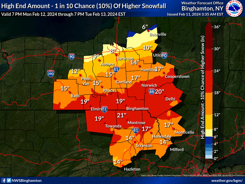
3 hours ago, crossbowftw3 said:
BGM’s high end map is eye popping. Banding could absolutely get going but don’t buy into the 18-24 shown across this lol
8-12 is a more realistic guess but wouldn’t be shocked to see 12-18 spots at elevation. Should be a blitzing kind of event where it’s in and out within 18 hours

Warning for 6-9” with locally higher totals now
-
BGM’s high end map is eye popping. Banding could absolutely get going but don’t buy into the 18-24 shown across this lol
8-12 is a more realistic guess but wouldn’t be shocked to see 12-18 spots at elevation. Should be a blitzing kind of event where it’s in and out within 18 hours
-
Watch for 6+ now…let’s lock and load
-
1
-
-
Early next week is curious but not placing much stock in it yet
-
1-1.5 that compacted into .5” overnight Sunday into yesterday and crusted over with sleet/ice.
onto February
4/1-4/2 severe threat (southern portion of subforum)
in Lakes/Ohio Valley
Posted
And when was the last 15 hatch across Ohio again?