

Danajames
-
Posts
67 -
Joined
-
Last visited
Content Type
Profiles
Blogs
Forums
American Weather
Media Demo
Store
Gallery
Posts posted by Danajames
-
-
GFS definitely trended north for the Saturday event but I have my doubts of me getting all snow. It looks like the Mason Dixon Line is where it will be snow, a la Monday all over again. I hope the model eventually shows more cold air farther south because if the 1800 run turns out to be accurate, the best we'll see in my neck of the woods is a sloppy mix with Baltimore and south just getting rain. Tuesday looks like a warmer run too.
-
 1
1
-
 1
1
-
-
GFS 0600 run has the Sunday system suppressed south of MD for the most part. Maybe extreme southern MD might pick up some wintry precipitation. The storm on Tuesday however, looks promising, although that one will be a close call also as far as the rain/snow line, similar to what we all experienced on Monday. It will be interesting to see how that declination between a cold rain and frozen precipitation evolves over the next several days.
-
1 hour ago, BristowWx said:
Sorry to hear that. Perhaps your luck will change next week. Pulling for you.
Thanks but to be honest with you, if someone said, "I'll stop all the heavy rain events but the trade off is no more snow either", I'd take it in a heartbeat.
-
1
-
-
1 hour ago, BristowWx said:
You didn’t get WSW criteria snow from the January storm? Where do you reside?
Live in Edgewood, which is southern Harford County. Winter Weather Advisory is the best I've been able to muster this winter.
-
1
-
-
3 hours ago, peribonca said:
Confluence to the north is a bit stronger/souther and shoves the precip a bit South. Not a bad place to be at this time.
And that's been the main song and dance this winter. If there is significant snow, it's been to the south of Baltimore. Otherwise, it's been all Great Lakes cutters bringing 1-2" of rain into the Mid-Atlantic. I've pretty much pulled the sheet over my area in any hopes of a WSW level snowfall happening before Spring finally arrives. But it's cool that Bel Air and going towards the PA line did get 6+ inches yesterday.
-
It was a nice little snowfall yesterday with my neck of the woods picking up around 3". Mainly sleet towards evening and then just intermittent rain overnight. And of course, the main event is yet another GL cutter with heavy rain. On and on it goes. It's so predictable that it's almost redundant at this point.
-
1 hour ago, BristowWx said:
A pure snow scenario is a tall order for most areas south of 70 east of 81. Rain will likely be part of this equation. No reason to fret over it.
Oh, I'm sure we'll get some rain but I just don't want any more of that heavy crap. After 70+" of precipitation last year, I'd like to start 2019 on a more "normal" pace.
-
The best case scenario is to get an early snow thump, have a period of lighter mixing if not to all drizzle and then the dry slot takes over and we say goodbye to the system. If we get any heavy rain out of this, I'm going to be pissed. That's the absolute last thing anyone needs or wants at this point.
-
1 hour ago, psuhoffman said:
Jb thinking it will get cold is a reason to be skeptical. I joked back in November that my biggest reservation was that my winter forecast matched JBs. I should have taken that more seriously. But I guess once in a while he has to be right just by blind luck so maybe this will be one of those times.
We shall see. But I was never convinced that we were embarking on an early Spring. The cold shots will last well into March.
-
Here's Joe Bastardi's take on the long range-
https://twitter.com/BigJoeBastardi/status/1092769611748130821
-
I think for the most part, the models do a decent job beyond 10 days recognizing pattern shifts that are coming but predicting specific storms? That's high comedy. They have enough problems 3-4 days out, let alone 2 weeks. I have no doubt we'll get more cold air before the winter's over but whether that equates to snowfalls is impossible to predict. I just wish it would stop raining. And when I was listening to my weather radio yesterday, I heard those dreaded 3 words- STALLED OUT FRONT. Just amazing to me that it would happen in the heart of winter but alas, here we go again with ripples of low pressure riding along it most of next week. I wasn't upset so much about the milder temperatures coming but more rain? The bane of my existence.
-
1
-
-
Snow was a complete bust for the most part in my neck of the woods here in southern Harford County. All we got was a dusting after a moderate rain most of the day. Areas north and west of here by only about 8 miles picked up around 2-3". Shows you how just a little increase in elevation can make a big difference in the rain to snow events.
-
11 hours ago, losetoa6 said:
Feb 2003 was special in that regard . Temp of 10 most of the day..it felt invigorating man
I remember that storm well. Woke up to 13 degrees and snow rates of 2-3" an hour. I've never seen or felt snow that dry in my life. You could literally use a leaf blower and just put the shovel away. Truly a rare event in this part of the Country. 2002-03 was one of my favorite winters here in MD.
-
For those of us(me included) that seem to lose power every time there's high winds, I'm a little concerned when the front starts to move through in earnest tomorrow. In some heavier snow squalls, winds could gust near 50 MPH and that often spells trouble. And you sure as hell don't want to lose power with the kind of temperatures headed this way. Hopefully, like last Monday, the lights will just flicker a few times. Everybody be safe if you're going to be out on the roads this evening and tonight.
-
1
-
-
I think 1-3" for any area is about right. Maybe southern MD/Eastern shore will have a hard time finally transitioning to snow and still getting an inch or two. One thing is for sure- the GFS's last few runs have been getting colder and colder which may negate much if any rain for locations north of Baltimore. We'll see how it plays out.
-
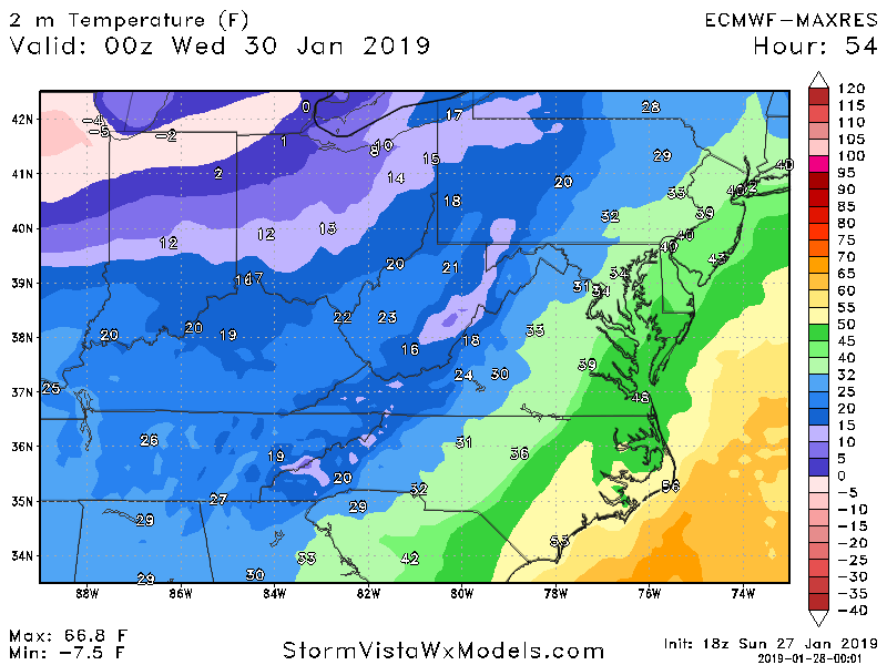
1 hour ago, DCTeacherman said:
My main concern with this event, as others have mentioned, is surface temps. These are the euro temps for 00z Wednesday. By this point most of our QPF has fallen and DC has about 0.1 left.
They'll definitely be marginal where I'm at but the past several runs of the GFS has shown some decent, if not brief heavy snow soundings with that window of opportunity. If it pans out that way, we could pick up a couple inches of snow relatively quickly. I've seen that scenario before and the last time it happened, we lost power for 3 days.
-
The noon GFS is still looking pretty good for late Tuesday. It's been consistently showing a swatch of 3-4" of snow for my part of MD. That's not bad considering. And the last few runs have trended Tuesday to be colder, even at the onset of the precipitation. So, it's very possible the rain only lasts a few hours before quickly changing to snow. I was hoping the cold air would sustain itself longer than a few days but by Sunday, we'll be back above normal.
-
1 hour ago, psuhoffman said:
I’m not in favor of that. If we did that every forum would be too small to have good discussion. People just need to deal including myself.
As far as snowfall goes, I'm fine with it. It is what it is. I just want the assembly line of soaking rainstorms to stop. But I'm certainly happy for snow lovers south of us and don't begrudge their contentment. It would be a wonderful world(for me at least) if every system during the winter was snow and not those depressing cold rains that the Mid-Atlantic is famously known for. Oh well, back to reality.....
-
On 1/25/2019 at 6:18 PM, showmethesnow said:
Just curious. If it is so predictable why are you even following the models then?
I don't know why. (LOL) I guess I must be some kind of a masochist.
-
On 1/25/2019 at 6:16 PM, DCTeacherman said:
Yeah this pattern has been truly awful, I’ve had 3 snow events in DC, I’m 2/3 of the way to climo, it isn’t even February yet, and we’re tracking a light event for Tuesday/wednesday with potential upside.....just awful. Did you just move here? Have you not been here for some of our shutout years?
It's true that areas D.C. and points south have had some decent snowfall. Even my sister in Richmond got over a foot with that one storm. But I'm in northern MD and we've gotten very little with maybe 3" being the biggest output. And as much as a snow lover that I am, I'm at the point with these relentless rainstorms that I just want to see dry, cold weather. If we get a small dose like what's coming Tuesday night(supposedly), that will be fine with me.
-
 1
1
-
-
Noon GFS still has the rain to snow transition into Tuesday night with what looks like 1-3". No phasing, though, which obviously negates any appreciable accumulations.
-
 1
1
-
-
The 0600 run of the GFS looked a little more bullish than the midnight return as far as snow potential Tuesday night. If that comes to fruition, I could see 2-3 inches. Of course, the noon run might look completely different.
-
2 hours ago, Ji said:
I'm sure the euro weeklies saw this. This is one of the worst winters I can remember. Its 01-02 to me

We'll still get cold periods into April. But as far as precipitation goes, the pattern isn't going anywhere anytime soon. By the time it ends, we'll be ready for the onslaught of stalled out fronts. Welcome to the new weather.
-
1
-
-
2 hours ago, psuhoffman said:
You forgot to mention it’s an older run (0z v 6z) of the euro vs the world. Don’t short change the severity of our crisis situation. But hey the day 6/7 threat is almost totally dead and then we go into a huge SE ridge and get more cutters according to all guidance so at least after this next fail we probably won’t need to waste much time on this for a while.
Wash, Rinse...Repeat. Great, isn't it?
PD Weekend 2019 Storm Threats
in Mid Atlantic
Posted
The usual model mayhem...GFS shifted back south overnight. Outside of extreme southern MD, most of the state is a miss with the Saturday event. It's unfortunate because the source of cold air aloft will be more prevalent at that time. Late Sunday's system still looks too warm to me...mix at best if anything does happen. And unless the colder air can lock in place on Tuesday as the warm front tries to move north, any precipitation with that one will be a mix too. At least in my neck of the woods. Overall, not too impressive over the next 5 days. If any of us in the area can get 1-3" at any given time, it should be considered a win.