TheRegionRat
-
Posts
128 -
Joined
-
Last visited
Content Type
Profiles
Blogs
Forums
American Weather
Media Demo
Store
Gallery
Posts posted by TheRegionRat
-
-
Walked the dog at six. Snowing hard. Probably three inches on the ground now. Winds are howling. I'll try to measure as I walk out the door for work. Best snowfall of the season.
-
 2
2
-
-
My location to Evanston. Twenty-five as the seagull flies, and three inches of snow.
-
4 hours ago, Hoosier said:
00z Euro has a spot of -38C 850 mb temps on the IL/WI border at 12z Wednesday.
Will be curious to see which model's 2m temp progs do best with this.
Hoosier, any data on the records for Gary? I distinctly recall the cold events of 1985 and 1996. The 2019 edition could take the cake.
-
Just now, RCNYILWX said:
-28 at SQI.
Sent from my SM-G965U using Tapatalk
Zero here in East Chicago. Amazing what a relatively small amount of distance coupled with less snowfall can do.
-
1
-
-
A general question here. Based on what the models indicate, what's the most moderation we can see? Would it be incredibly surprising if Chicago has a temperature above zero next Wednesday and Thursday?
-
The snowpack here didn't break, but it is bent. The temperature has risen from 38 a few hours ago to 39. Relief is nearby. It's 37 in Lansing, 33 at Midway and 31 at O'Hare. This weather always brings me down.
-
 1
1
-
-
No snow here. Had sleet at 5:30PM. Roads were slushy.
-
Last week, most of the Chicago people were quite surprised and disappointed once it became evident that the American guidance followed the Ukie and Euro 24 hours out or so.
-
1 hour ago, DaveNay said:
My in-laws used to live at Indy and Carrol (In the shadow of the old bridge)
Frogsville!!!!
-
1 minute ago, RCNYILWX said:
Thanks. So 6.5 for an average?
Sent from my SM-G965U using Tapatalk
6.5 is very reasonable.
-
1
-
-
52 minutes ago, RCNYILWX said:
What's your location? Will pass your report to my office when you do measure.
Sent from my SM-G965U using Tapatalk
I live on the South Side Of East Chicago, Indiana. I measured six inches in several locations and seven inches in a handful of locations. That's total snowfall.
-
1
-
-
1 hour ago, KeenerWx said:1 hour ago, janetjanet998 said:
i would have to think at least 6-8 inches around GYY ..the poster in munster said he had 3-4 inches in 90 minutes under weaker bands and that was over 2 hours ago
GYY has had SN+ last 3 hourly obs
that mesolow may be breaking down some...we will see
Any guesses as to how much has been put down?
I'll say 6-8. Was pretty close to a white out around an hour ago. I'll get out and measure in a bit.
-
27 minutes ago, Hoosier said:
The area around the Region Rat is probably getting it good. Hopefully we hear something.
I just returned home. Typical lake effect. I left my house at around 7:45 and it was sunny to my immediate west, and not snowing at my house. I live right by Kosciuszko Park. I drove to work to assess our lots, to determine if we need to bring in a loader to move snow or if we can do it ourselves with our plow. Work is in Hammond between Indianapolis Boulevard and Kennedy Avenue. It started snowing when I turned east off the Boulevard. Moderate snow at work. Went east to Kennedy, maybe a half mile. Snowing hard. Drove north on Kennedy back to East Chicago, heavy snow moderating to light snow to no snow. Drove to Montrose Deli in Chicago via LSD to buy Polish food. Sunny. Return trip the cloud wall was evident along the state line. Light to moderate to heavy snow along Indy Boulevard north to south. Heavy snow in Whiting. Very heavy snow as I type.
-
1
-
1
-
-
2 hours ago, ILSNOW said:
Like hitting the snow lottery..lol...
-
 1
1
-
-
Still snowing at respectable rate. Not sure how much life this band of snow has left. Heading out to lunch. Will have a great view of the Lake. Looking forward to some LES tonight.
-
1
-
-
Three to four inches here. Blowing around quite a bit. Has snowed since 3AM. Light snow continues to fall.
-
4 minutes ago, Chicago Storm said:
Pretty close to +SN here right now...just pouring snow.
+SN DPA.
Snowing at a really good clip now......FINALLY!! A good inch has fallen the past hour, which is the storm total here. Radar looks good, and the various models continue to forecast a lake plume to develop.
-
12 minutes ago, Hoosier said:
How fast the band moves through our area is critical. Here's a NAM forecast sounding I pulled from the middle of the band (offshore of IL) valid early Sunday. Excellent lift right through the dendritic growth zone.

The low level flow sort of breaks down/weakens with time on Sunday, so I think the band behavior/movement could become increasingly difficult to predict. Still looks like it could bend back west later Sunday into Monday, likely starting to weaken by then.
The lake effect is certainly the deal maker for the higher totals. Typically, you in Griffith will see a few more inches than I will.
-
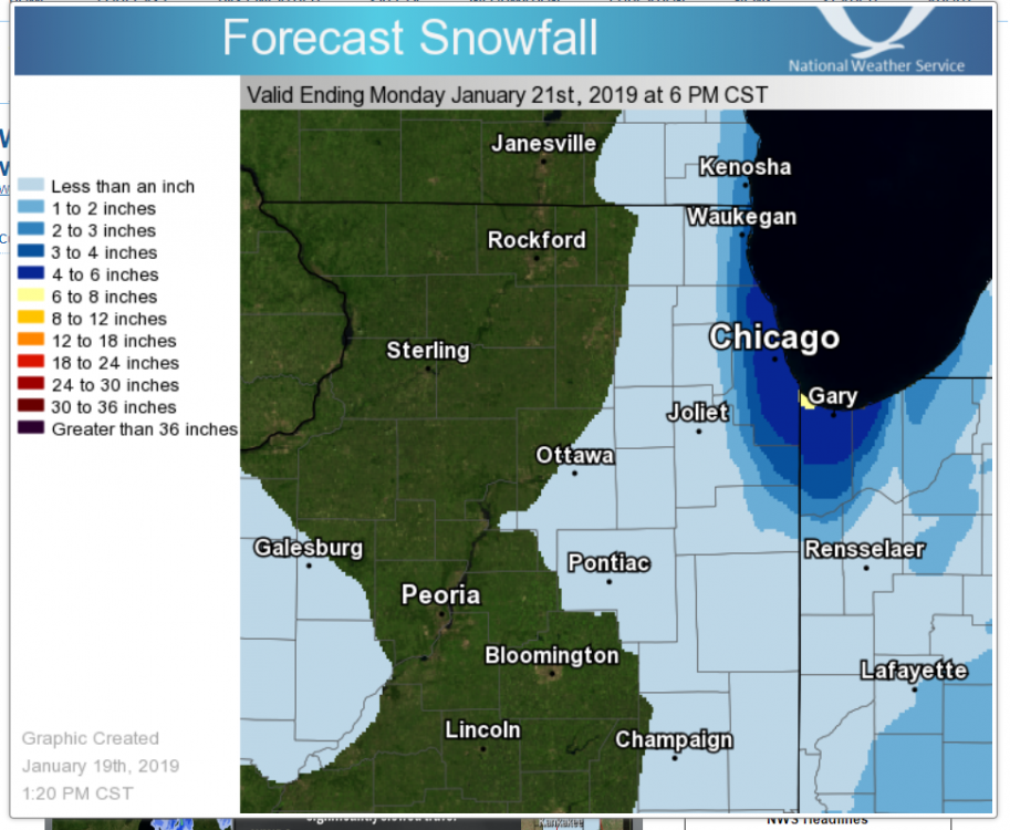
45 minutes ago, whoosh said:
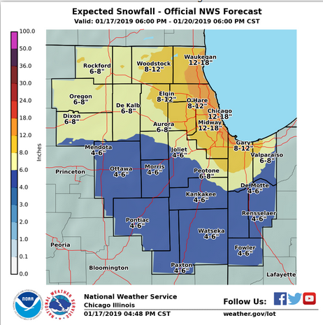
However, the 50% probability tops out at 7" unless I'm understanding badly.
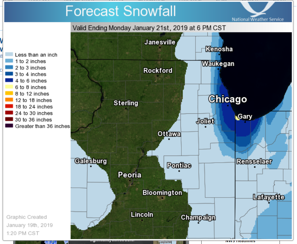
https://www.weather.gov/lot/winterWow!!!! Hope it pans out. I'm just inside the 12-18 zone.
-
LOT AFD updated for those that are interested. Izzi penned it, although it lacks his usual flair.
-
Curious, how has the Euro performed the last few days at 2-3 days?
-
Looking at GEFS individual ensemble members. A couple of trends to take note of between 00Z and 06Z. Much better clustering at 06Z at hour 66. All members sans four in the panhandle of Texas, whereas the 00Z had several in Oklahoma, a couple in Kansas, and couple lagging behind in New Mexico, and two in Mexico. At 06Z hour 72, all members are in Oklahoma, compared to the 00Z which had some in Texas. At 06Z hour 78, there's less spread than hour 84 in the 00Z, again, the southernmost members are not in Texas.
-
1
-
-
I doubt I know others on the board. Thanks for the welcoming. Looking forward to what we all hope is a good storm.
-
Just biding my time. Will wait until tomorrow. Really want to go all in. Meanwhile, I'll just enjoy reading the analysis that members post. Plenty of snow maps available, which I label "for entertainment purposes only."

January 24 - 31 Cold Blast
in Lakes/Ohio Valley
Posted
Hottest topic in the subsection...lol...
-18 here. The sun is out. Furnace is working overtime.