

Billypg70
-
Posts
52 -
Joined
-
Last visited
Content Type
Profiles
Blogs
Forums
American Weather
Media Demo
Store
Gallery
Posts posted by Billypg70
-
-
51 minutes ago, burrel2 said:
I know it's the 84hr NAM, but it looks like great for Upstate SC. 850's around -5c with surface dew points in the low 20's and heavy precip crossing the state line from Georgia.

That is a thing of beauty.
And the coldest levels right over Greenville County.
That could accumulate quickly,
Instead of the usual burning off over half of the system just bringing the BL to freezing.
And at this point no model can be dismissed.
In fact the NAM handled the last storm with the most accuracy even at long range.
-
7 minutes ago, oconeexman said:
Kiss of death...CJ just made a fb post about the threat already
Yes he is already explaining the setup and showing the Euro & GFS ensemble possible solutions.
He said something that I'm sure most would agree board wide this is the best threat we've had this season.
I doubt he'll be the KOD.
He has some weenie in him and as a snow lover I Love it.
-
 1
1
-
-
4 hours ago, msuwx said:
Pet peeve alert....
This is largely a board for weather enthusiasts. It gets very old when the flood of the same, tired, snide comments come in after someone posts a medium-range model map. I think everyone reading this board is aware a single run of a deterministic model (or single ensemble member) will likely never verify in the extended medium range.
But what are people supposed to post? A picture of an overcast sky? The purpose of the board is to discuss whatever there is to discuss, and unfortunately for snow fans, medium-range snapshots are about all we've got.
End of rant... back to your regularly-scheduled programming.
Great post and TY for ur contributions on this board.
We have some great posters.
Guys like Burrel2, Lookout, & wow.
And there are countless others.
I get why some are disappointed.
But winter's not over regardless of how badly the indices have been.
This is the Southeast and in some cases the deep south.
I'd imagine the vast majority of snowstorms south & east of 85 from NGA to Raleigh happen during bad indices.
Also the models are a tool and should never be the only thing that determines a forecast.
To many novelist take each run verbatim.
-
6
-
-
It starts with very very light pin flakes for about 30 mins.
Then picks up with intensity from there.
-
Just starting with flurries here in Greer
-
Just looking at observations.
Gainesville was reporting Heavy Snow & Freezing Fog 30/29 the temp dropped 2 degrees since last report. DP rose only 1 degree.
Great reports down stream.
Burrel are u in Pickens?
Any thoughts from Burrel or Lookout on Grenville County?
Tia
-
It snowed this morning here in Taylors SC which is NE Greenville County for an hour to an hour and a half this morning.
I was running late so only took one pic of my windshield.
There was a dusting in most grassy areas.
Nothing on the road.
I tried to post the pic but i am getting a message file is too big.
-
1 hour ago, mackerel_sky said:
There’s really a lot of chances and close calls starting this Monday, right thru mid Feb!! If most don’t see flakes, I would be shocked! CJ on 4, is dying to hype up a snowstorm since John is gone! Hopefully he gets to soon! I’m a Fox Carolina morning meteorologist kind of person!

I have no idea why????
NP
Yes CJ is just dying to hype a winter storm.
Two things you can count on in the western Carolinas TV market.
1 CJ giveth the SNOW
2 KK taketh it away...
-
1
-
 1
1
-
-
23 minutes ago, mackerel_sky said:
Nobody told me how good the 12z GFS was! Snow on snow here! The best run I’ve seen since Feb 2014
Something must of changed drastically because the meteorologist on WYFF a couple of days ago were talking a few degrees above normal for the next couple of weeks.
Now their saying we need to keep an eye on the same time period,
With cold air near by & moisture staying plentiful.
-
1 hour ago, RT1980 said:
Man,
I get it. I live near Raleigh but work close to Charlotte I have an apartment for work and am home when off. The last few years have been comical to me almost to the point of tearing my hair out. If I was home the the Charlotte are would get a few inches and if I was at work they would get it at home! I just would like to see some snow either way. What I was getting at is that based off of history at some point it’s going to happen this year. If not then so be it! I also understand that for your location it’s more of a rarity.
Wyff 4 local NBC for the Western part of the Carolinas had a Winter special 2 weeks ago today.
They stated in that special that only one time since records begin at GSP has GSP not had measurable snow.
2012.
There's obviously an acute line in terms of winners & losers for snow lovers.
Those NW of 85 tend to see much more snow than those SE of 85.
That line extends from NE GA thru GSP to Charlotte & RDU.
Example Mack & myself.
Last December I got 6 inches by the NWS in Greer and from my own measurements.
Mack got less than an inch.
We probably live less than 20 or 30 miles from each other.
This seems to be the case for anyone in the aforementioned I85 area from NE Ga north to Raleigh.
-
 1
1
-
-
11 minutes ago, ryan1234 said:
If that actually came to fruition most of the state's population would be without power. And we'd end losing a lot of trees. It would make Hugo look like no big deal...

In 02 & 05 GVL county had 2 huge ICE storms.
I believe in 05 Duke Energy estimated that 95% of the County was without power at the height of the outages.
Greenville county at that time had around 750k living in the county.
Greer deemed that between 1.25 & 2 inches of freezing rain fell,
In and around Central & Northern GVL county.
I remember it raining hard & temps hovering between 23-25 during the heaviest rains.
You could hear transformer after transformer popping throughout the night.
On the morning drive.
More than half of the power poles I past was down.
I was without power in NE GVL county for almost 2 weeks.
My mother who lives on the side of Paris mountain didn't have power for almost 6 weeks.
As a winter weather lover.
I never want to see another freezing rain event of that magnitude.
-
Here was the thoughts on the long range of the GSP discussion.
Dry and cold conditions will return in the wake of the front, with
temps a few degrees below climo on Wednesday and even colder Thu
and Fri. Our next opportunity for precip likely will result from
a shortwave inducing cyclogenesis near the Gulf Coast near the
end of the week. The details remain murky, with model solutions
reflecting an uncomfortable amount of spread in both timing and
location of said cyclogenesis. Those solutions that do depict the
low affecting our area generally do so after the Arctic high has
set up over the East Coast, implying some possibility of wintry
precip at least at the onset of the event. Most likely this
would occur on Friday but some ensemble members bring it in late
Thursday; just to underscore the low predictability of the event,
the Canadian GDPS actually doesn`t show any system at all. Until
the guidance comes into better agreement, all we can say is that
Thursday thru Saturday remains a period to be watched.
-
Maps please?
-
1 hour ago, burrel2 said:
Here is what the GFS showed at a 5 day lead. Does that look accurate to you?

Lookout & yourself are a couple more posters that I really love to read.
You guys are well versed in reading models and knowing the climate in the NE Ga & Western Carolina areas.
I agree with the assessment that each setup will stand or fall on it's own merits.
Obviously there are certain areas more likely to benefit from CAD as opposed to others.
The closer you are to the East Side of the Escarpment the better your situation,
I live just East of Paris Mountain in NE Greenville county and it seems these CAD setups do tend to over perform here,
But I am in a pretty good location to keep that Damming deeper and a longer period of time.
The further east & south you go,
You open the door for the dreaded warm nose.
We had about 3 hours maybe 4 of sleet with some snow mixed in here in the Blue ridge, Taylors, & Greer areas.
A few times car tops were whitened.
It definitely over performed based upon my expectations.
-
32 minutes ago, Iceagewhereartthou said:
Still can't get 6 inches in western upstate

I see a 7 sitting over either wahalla or Seneca
That qualifies as Western Upstate
-
50 minutes ago, Cold Rain said:
It's trickier to put together a storm in the SE than to have one tracking across the entire southern tier, where we can watch it all the way in. But like Gboro said above, the southern jet probably isn't going anywhere. The Euro books the MJO through phase 6 now, and even the GFS is perking up in that regard. I don't see us transitioning away from a cool/cold pattern for too long. And with all of the various shortwaves moving through, we could pop a storm at any time. It's the type of pattern where you likely won't get a lot of lead. I've been burned so many times over the last several years relying on northern stream stuff. Missed storms to the north, west, south, and east. But that said, there's no good meteorological reason to be overly pessimistic here.
I've been following you and others on this board for probably more than a decade.
I couldn't agree more with your last 2 posts.
I get so sick about hearing how we can't get snow because of a lack of -NAO.
Even years we have had -NAO's & other indices in favorable positions.
We still depend upon timing.
I understand there's certain ppl on this board who I respect or enjoy seeing their posts who are 20 to 50 miles off from nothing to literally 6" or more.
Mack lives within 30 minutes or so of me.
The last 3 storms he has gotten either flurries or nothing while I had 3" December 17, 4" January 18, & 6" inches in December 18.
That has to be frustrating as hell.
I feel for him and others on this board.
The last time I remember a board covering snow was middle Feb 14.
We have plenty of time regardless of modeling.
Also models are tools.
You guys know you can't take each model verbatim.
I seen someone talking about how spot on they were for the last few weeks.
I disagree,
Just 3 days ago I was supposed to be mid to upper 50's today.
I have not been above 43 today.
That's a bust to me.
Listen to guys who know what their talking about.
I still believe we will have a pretty big storm or 2 that covers most of the board.
Probably not all but,
If you live in coastal areas or the Midlands you really shouldn't expect a winter storm but every 5 to 8 years.
-
2
-
2
-
-
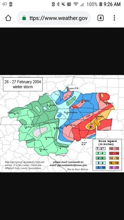
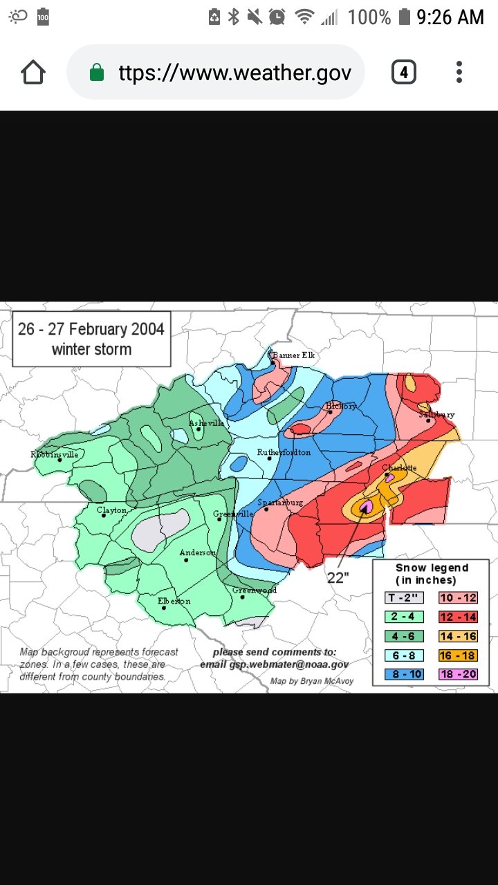
22 minutes ago, Queencitywx said:
CLT did not get 2 feet in that event, maybe 4-6". Foot line started around Marshville.
Sorry guys closing in on 50 and some of the years are running together.
I got the Carolina Crusher confused with what must of been Carolina Crusher 2 looking at the snow map
Feb 26 & 27 2004
-
2
-
-
6 minutes ago, Bob Chill said:
Lol- i wouldnt jump to any quick conclusions. The next 10-12 days will feature several sig below normal airmasses and flow remains active from what we can tell. The neg pna (if it happens at all) looks to coincide with a very negative epo and modestly negative AO. While guidance has backed off on a stout -nao, there is no indication of a +nao. If anything the nao looks like it will still go negative or at worst neutral.
One huge difference between a bad pac in Dec and what is progged in early feb is Canada is likely going to be an icebox. As long as the -epo holds (looks very negative in the long range) there will be very cold air across all of Canada. Any intrusions into the conus with be quite cold. In Dec the pac jet blasted every last molecule of cold air off the face of the continent. There's no comparison to late Dec/early Jan from what I'm seeing.
Lastly, this new twist with the PNA could end up not happening at all or be brief. We'll just have to see how it goes. In a simpleton view there are only 2 kinds of winter patterns... a shutout pattern or one that could potentially produce frozen precip. After thursday it looks like a decent pattern for some snowfall in both our regions. Not amazing but far better than what most of winter has been like. It should also feature some pretty cold air. Before we worry about d14+ we have to see if we can score before the month is out or in early Feb.
Final thought... We can still score with this type of -pna. Arctic air will be abundent in our source region. High pressures will move across to the north. This can set up CAD events or gradient overrunning events. There's no way to know specifics. Let's focus on the period in front of us because the ingredients will be available for winter wx. By the time we get through the next 10 days or so there will be brand new reasons to worry in the long range. Lol
Bob,
Love your input.
I'm just curious.
I was born in 70 and can remember when it wasn't that rare for troughs to engulf the entire country.
77-78 comes to mind.
What can cause the entire country or close to the entire country to be colder than normal?
Could this be setting up in this current modeled pattern?
-
12 minutes ago, Queencitywx said:
this
1 minute ago, Orangeburgwx said:I saw that too

I understand that down ur way,
U don't get a lot of action when it comes to winter weather but I don't think u want to jinx this either.
There's plenty of time to get a thread.
Let's get some type of general consensus before starting a thread.
I'd say within day 4 or 5 with more model consensus.
Lord know we need to get Mack & No snow for you some snow this year.
They have been more antagonistic & pessimistic than usual.
-
3
-
 1
1
-
-
6 minutes ago, StoneColdWeatherAustin said:
I believe they were saying they got 6 back in December and had the ice last weekend.
Sent from my SM-N950U using Tapatalk
Exactly
I edited that post
-
1 hour ago, Waiting on snow said:
Not even close to historic. Half the board hasn't seen a flake. And temps have been above average the entire time so far. Dec was +1-3 depending on location and Jan is +5 so far, although that looks to surely plummet.
I get that some on this board has had a rough time since 14,
While I haven't had the epic year Big Frosty has had,
It's been pretty good for me here in Northern Greenville county.
I had 6 inches of Snow in December and ice last Saturday.
I believe that most on this board will see at least 1 more moderate winter storm before seasons end.
-
27 minutes ago, mackerel_sky said:
If that happens, dinner on me at Twin Tops!
")
Mack you obviously didn't see John Cesarich's forecast tonight between 4-6:30
He mentions the pattern change starting Sunday.
With arctic air over the entire SE next week.
With a BAJA low entering SOCAL early next week & rolling along the Gulf Coast.
Setting the stage for a MAJOR WINTER STORM next Thursday into the weekend.
Reminds me of how Charlie Gertz called that 88 storm 2 weeks out......
Something big is on the way...
The signals are all there !
-
3
-
1
-

One More Shot: Feb 20-21 Event
in Southeastern States
Posted
We live in the South East.
I have always believed that more than half of our snow storms are usually thread the needle events.
The teleconnections do matter but it snows in bad patterns,
This last decade proves as much.
BTW Grit Thank you for all ur valuable input on this board.