

JustMePatrick
-
Posts
34 -
Joined
-
Last visited
Content Type
Profiles
Blogs
Forums
American Weather
Media Demo
Store
Gallery
Posts posted by JustMePatrick
-
-
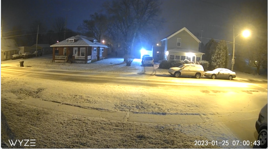
I'm south of Findlay, looks like snow began to accumulate around 4:30 AM. Below is a 7AM snap shot of one of my cameras.
-
The Wind for those of us in Ohio/MI will be insane.
-
https://www.spc.noaa.gov/products/md/md0252.html
Mesoscale Discussion 0252
   NWS Storm Prediction Center Norman OK
   1012 AM CDT Thu Mar 25 2021

   Areas affected...central and northern Mississippi and
   Alabama...parts of southern Tennessee

   Concerning...Severe potential...Tornado Watch likely

   Valid 251512Z - 251745Z

   Probability of Watch Issuance...95 percent

   SUMMARY...Ongoing storms from Mississippi into Alabama may
   consolidate into supercells through midday with developing tornado
   threat. A tornado watch is likely by early afternoon.

   DISCUSSION...Ongoing activity over eastern MS and into AL has been
   elevated for much of the morning, but cells now extend southwest of
   the warm front which is situated from from northern MS into central
   AL. Radar trends show that cells within these areas have acquired
   rotation as they attempt to transition from elevated to surface
   based. This may happen over the next couple hours as temperatures
   warm into the 70s F with the warm front lifting north, maximizing
   effective SRH. Therefore, it is possible that these cells develop a
   tornado threat over the next few hours. 0-1 km SRH of 300-400 m2/s2
   along the warm front will favor strong tornadoes as the stronger
   instability develops into the warm advection zone.
-
-
Other parts of Ohio got absolutely hammered with an ICE STORM the 2nd time in less than a week. Over 12K without power:
https://www.facebook.com/1415859523/videos/10219355666708492/

-
 1
1
-
 2
2
-
-
https://www.spc.noaa.gov/products/md/md0093.html
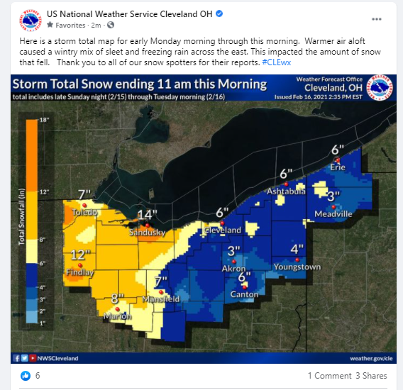
SPC calling for 2+ inch per hour rates.
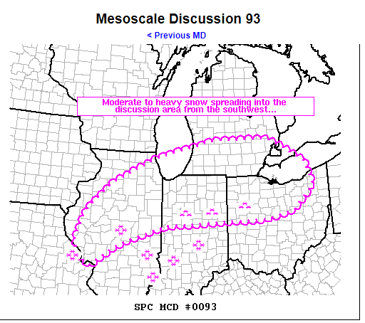
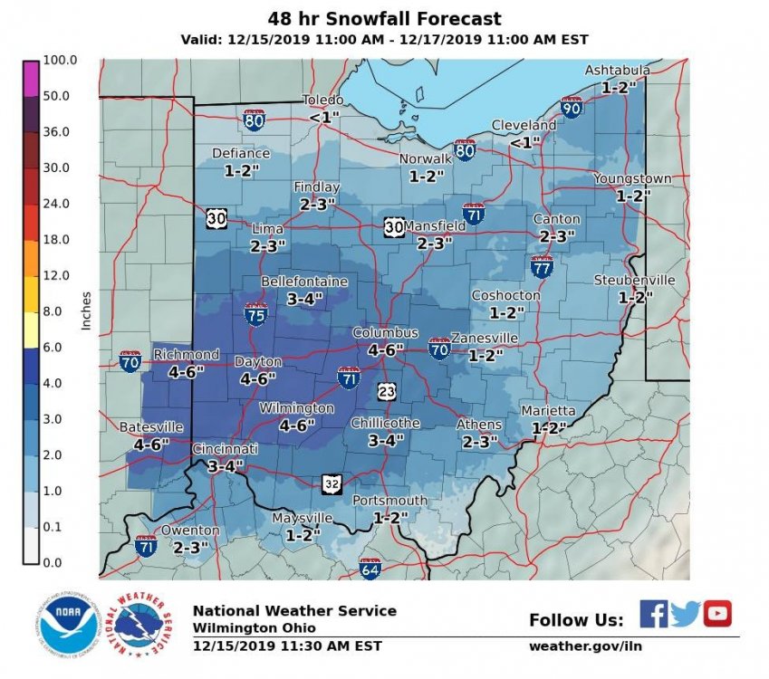
 Mesoscale Discussion 0093
   NWS Storm Prediction Center Norman OK
   0252 PM CST Mon Feb 15 2021

   Areas affected...central/northern Illinois...southern Lower
   Michigan...northern/central Indiana...northern Ohio

   Concerning...Heavy snow

   Valid 152052Z - 160245Z

   SUMMARY...Moderate to occasionally heavy snow will overspread much
   of the discussion area from the southwest over the course of the
   afternoon/evening.  Localized areas will received 1-2+ inch per hour
   snow rates.

   DISCUSSION...Broad, large-scale lift associated with a mid-level
   wave across Kansas/Oklahoma continued to maintain a broad
   precipitation shield across much of the Midwest currently.  The
   precipitation continues to fall as snow (heavy at times) across much
   of southern Illinois and Indiana.  The precip shield is outpacing
   many models in its northeastward progression and will overspread
   much of the discussion area from south to north over the next
   several hours.

   Within the precipitation shield, it appears that a subtle shortwave
   over western Tennessee has provided forcing aloft for enhanced
   snowfall rates across southern Illinois and Indiana.  Most of the
   heavy snow reports have been concentrated in this area, and
   localized banding may result in 2+ inch/hour rates as this area
   spreads northeastward into Indiana/northwestern Ohio over the course
   of the afternoon.

   Farther west, a few bands have also produced heavier snow from the
   St. Louis area through central Illinois.  This axis of snow should
   shift northeastward toward the Chicago Metro area and portions of
   southern Lower Michigan over the next several hours, with 1
   inch/hour rates probable beneath heavier bands.
-
3
-
-
-
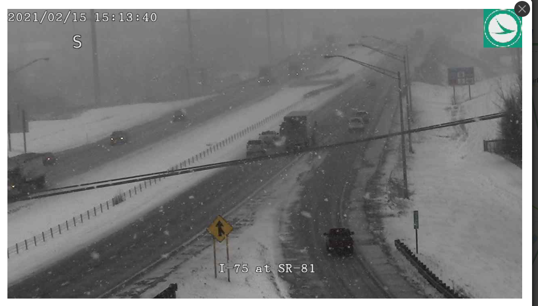
This is the OHGO camera in Lima at the I-75/SR81 Interchange. You can see the flakes!

-
2
-
-
https://www.spc.noaa.gov/products/md/md0088.html
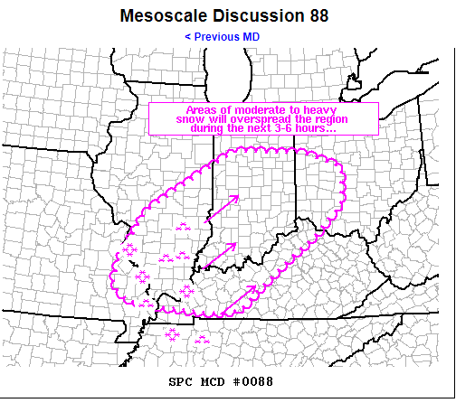
Areas affected...southeastern Missouri...northern/western
   Kentucky...southern Illinois...much of Indiana...southwestern Ohio

   Concerning...Heavy snow

   Valid 151644Z - 152245Z

   SUMMARY...Heavy snow near the Mississippi River will spread
   northeastward across much of the discussion area over the next 3-6
   hours.  Accumulations of 1-2 inches per hour are possible in heavier
   bands.  A few areas of sleet may also mix in with the snow across
   Kentucky.

   DISCUSSION...Lift associated with an approaching mid-level wave over
   Oklahoma has resulted in a broad area of moderate to heavy
   precipitation from eastern Arkansas/western Tennessee southward to
   the central Gulf Coast.  Much of the precipitation has fallen as
   heavy snow, though sleet has mixed in with the precipitation across
   western Tennessee at times.  Additional bands of precipitation are
   developing in southern Illinois and southeastern Missouri currently,
   where recent METARs indicate heavy snow in Carbondale, IL; St.
   Louis, MO; and Poplar Bluff, MO.  This snow has developed roughly
   1-2 hours faster than this morning's 12Z model guidance.

   With broad-scale lift approaching the discussion area, the
   expectation is that snowfall rates will continue to intensify as the
   expanding precipitation shield moves northeastward across the
   discussion area.  Areas of 1-2 inch/hour snow rates are expected in
   heavier bands.  Model forecast soundings across Kentucky indicate a
   warm layer between H7-85 that may allow for sleet to occasionally
   mix in with snow across Kentucky.
-
-
50 minutes ago, Jim Martin said:
NWS Cleveland mentioning risk of snowfall rates 1-2" per hour tomorrow night across their CWA.
This is the part of the discussion that Jim mentioned earlier from CLE:
Source: https://forecast.weather.gov/product.php?site=cle&issuedby=CLE&product=AFD
.NEAR TERM /THROUGH MONDAY NIGHT/...
The big weather story for the near term period is the
significant Winter Storm developing across the south central
CONUS and Gulf Coast region. This Winter Storm will bring heavy
snowfall and big travel impacts Monday into Tuesday.

Quiet weather is expected for this evening. Below-normal low
temperatures eventually reach the lower and middle teens
overnight. High and mid level clouds and moisture will increase
this evening ahead of the initial mid level wave of energy in
the broader southwest flow aloft. Forecast confidence is high
along with good agreement in model guidance of widespread light
snow developing southwest of our region tonight. Isentropic lift
will allow snow to gradually overspread our CWA from the south
and west after midnight tonight. We are expecting this quick
hitter of primarily light snow to impact the Monday morning
commute. Bursts of moderate snow should occur as moderately-
strong ascent manages to be maximized in a cloudy DGZ at times.
Fresh snowfall by midday Monday is expected to reach 1 to 3
inches. That system will be out of the region by midday and will
be followed by lingering light snow through the afternoon as
weak isentropic lift occurs and some slight lake-enhancement of
snow happens generally south and especially southwest of Lake
Erie. Additional snow accumulations should be less than one inch
Monday afternoon. Daytime highs should range from the upper
teens in the far west to the mid 20`s in the far east.

There have been some changes and adjustments for the main winter
storm system impacting the region Monday evening through Tuesday
morning. Guidance has shifted the track northwest along with
higher QPF and available moisture. Forecast models have also
shown a slightly stronger system and a very favorable track to
bring heavy snowfall to our area Monday night. The Monday
evening travel commute may be highly impacted and challenging
as the snow quickly ramps up. We are highlighting the 5 pm to 5
am time frame as the worse conditions and the heaviest snowfall
rates. We may see a decent deformation zone develop tomorrow
evening as this system gets fully developed and bands of heavy
snow with rates 1 to 2 inches per hour potentially. The other
wild card will be the increasing northeasterly low level flow
and surface winds tomorrow night coming across the long fetch of
Lake Erie. We may see some lake enhancement of heavier snow as
well near the lakeshore areas from the Cleveland metro area to
the Toledo area. Our overall snowfall forecast totals are
widespread 8 to 12 inches with lower amounts closer to east
central Ohio and the higher amounts further northwest and
lakeshore areas. There is some potential for pockets of higher
amounts over 12 inches especially if we have some lake
enhancements or true lake effect snow showers as this system
pulls away Tuesday morning.
-
1
-
-
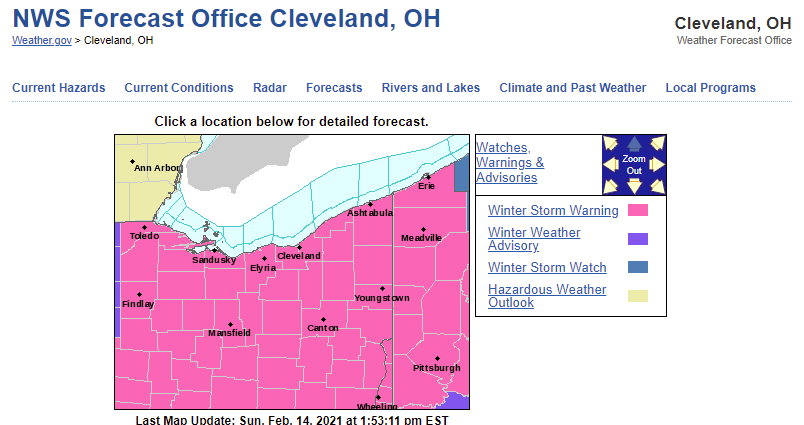
CLE has bumped the rest of their CWA to a warning that was previously in a Watch or an Advisory.
-
CLE morning discussion:
.SHORT TERM /6 PM THIS EVENING THROUGH TUESDAY NIGHT/...
A pair of snow events are targeting the area for the short term
forecast period, bringing widespread, significant snow
accumulations from early Monday morning to Tuesday afternoon.
A surface trough will enter the region from the southeast on
Sunday night and nudge north into the Ohio Valley by Monday
morning. This trough will be supported by the right entrance
region of an upper level jet, isentropic lift, and moisture
advecting north from the Gulf of Mexico. This feature will
bring the first round of snow to the forecast area beginning
early Monday morning and extending through early afternoon.
Trends with this portion of the snow event are up and have 1 to
3 inches of snow west and 2 to 4 inches of snow east, all of
which will have an impact on the Monday morning commute. Now
that we are entering the window for some higher resolution data,
there are signals that this total could be bumped up a bit
higher, especially west over NW Ohio. This will need to be
something to watch for in future forecasts.

In previous forecast editions, it was advertised that there
would be a break in the snow on Monday afternoon and evening
before the next round and trend this morning show that the
timing of this break is shrinking as the first trough seems to
linger. At this point, still expecting light snow during this
break period with new accumulations up to an inch. The main show
will be on Monday night into Tuesday as a shortwave trough over
the south central CONUS will support the development of low
pressure over the northern Gulf coast. This low will move
northeast along the East Coast states through Tuesday.
Meanwhile, the forecast area will be on the back side of this
system and cold, so all snow is expected. As the low passes by,
a TROWAL (trough of warm air aloft) will set up across the area,
centered at roughly 700 mb, and lower level frontogenesis will
occur over the area, further forcing snow development. Meanwhile,
a new upper level jet enters from the southwest and the area
will be squarely in the left exit region on Monday night,
giving even more support for snowfall development. So what does
this mean? Widespread heavy snowfall is expected to develop
over portions of northern Ohio and NW PA with 4 to 8 inches of
additional snow expected by Tuesday morning. However, with all
of these features aligning, there is the potential for some
mesobanding across the area and snowfall amounts may be higher
than currently forecasted. This will need to be monitored going
forward. In addition, some recent short term guidance members,
most notably the NAM, have this heavier swath of snow further
west than the current forecast and this trend will also need to
be monitored.

This morning, we have decided to hoist a Winter Storm Warning
for most of our forecast area with a Winter Weather Advisory
for portions of Northwest Ohio. This event is tricky with the
exact messaging with multiple rounds of snow in a short window with
a snowfall duration of 27-30 hours in most areas. With snow
totals of 8 or more inches in that time span, the impacts of
snow will be felt across the region and merits issuing a warning
headline. In addition, there is potential for totals in
isolated areas to be higher (a foot for some), whereas the floor
of snow potential is still 5 to 6 inches in warning area, which
isn`t nothing. In addition to snow impacts, temperatures will
be cold through the event and with even a 10 mph wind, wind
chills in the single digits to near zero are possible.

The system departs to the east on Tuesday and while the heavy
snow will be quick to leave, residual moisture will linger
across the area and light snow showers are possible through
Tuesday with light accumulations. Tuesday night should be mostly
dry. Temperatures on Tuesday appear to be the coldest in
sometime with widespread single digits with breaks in the clouds
and a fresh snow pack to allow for temperatures to plummet.
-
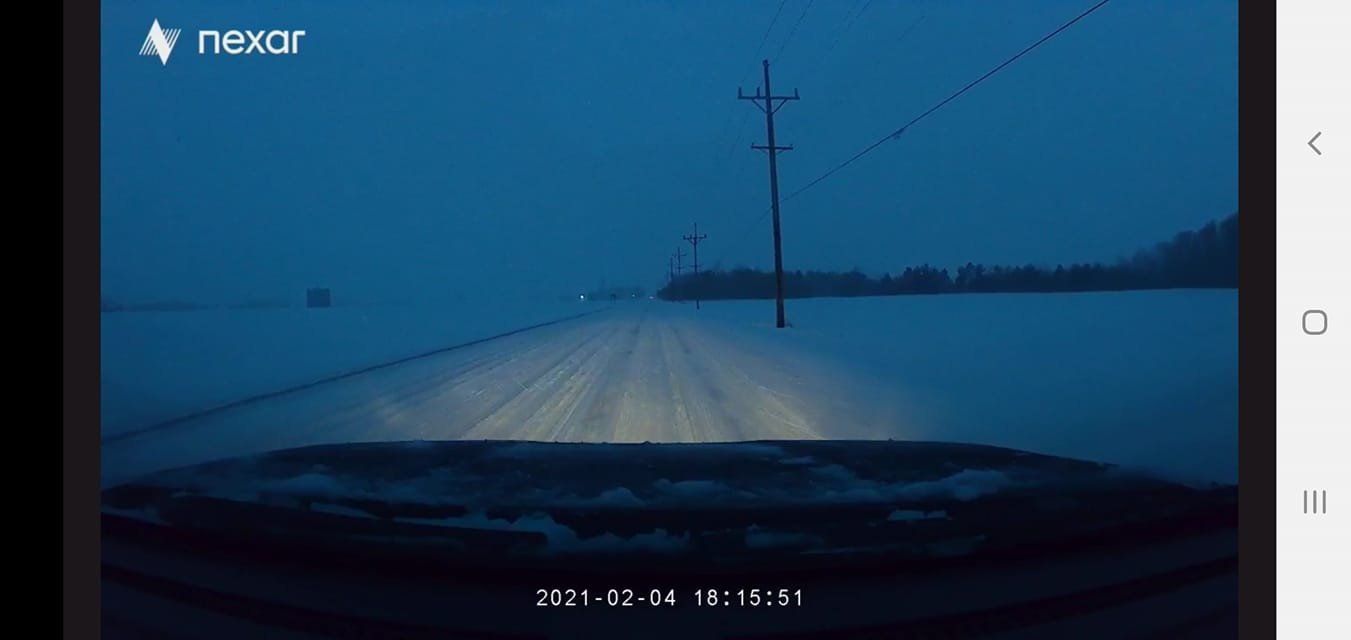
@Jim MartinThis was my view South of Findlay on CR 313. Bad Drifting and ruts. It piled up very quickly for sure!

-
1
-
-
NW Ohio, Findlay, Snow has started, just made mping report. Pic is from Parking lot at work.

Sent from my SM-G975U using Tapatalk-
1
-
-
NWS Wilmington Forecast.
-
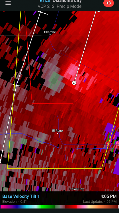
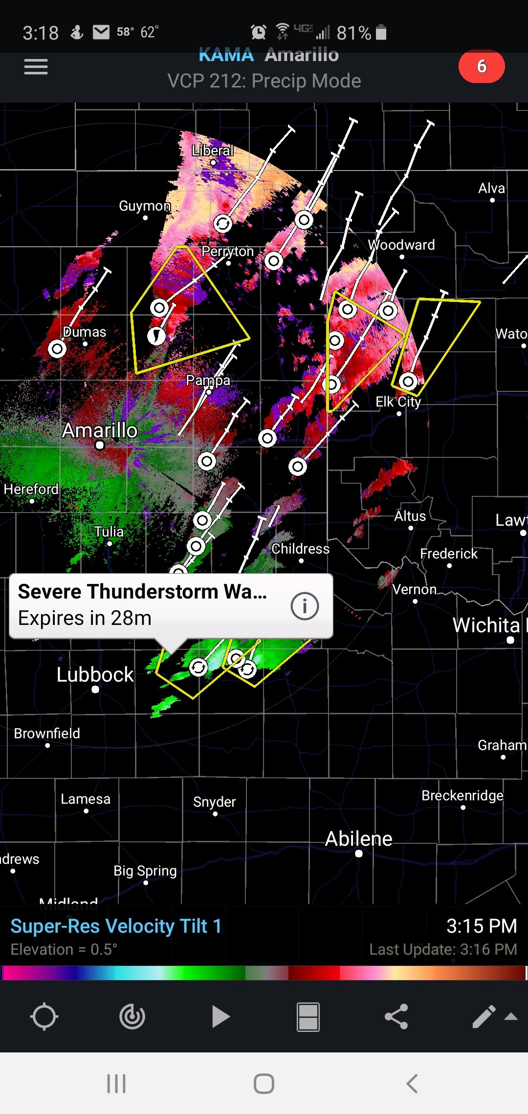
Distinct Velocity couplet on the storm just north of El Reno.
-
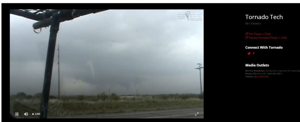
From Tornado Tech's Stream just a few seconds ago. He is on the move now.
-
1
-
-
-
Local News MET on Social Media just a few minutes ago:
-
1
-
-
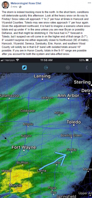
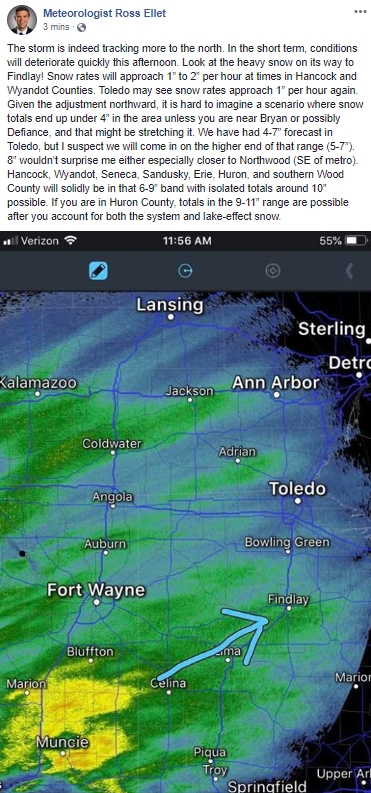
Storm Trending further North and strong, likely increasing snow totals across NW Ohio.
-
2
-
-
Light snow is falling in Rawson (Hancock Co, OH, South of Findlay). Light dusting on streets and driveways.
Sent from my SM-N950U using Tapatalk -
Here's a better look without all the aiport codes.

Sent from my SM-N950U using Tapatalk -
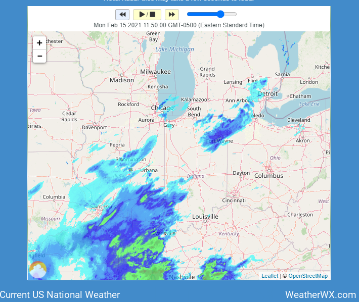
Current Radar for Midwest/Plains.

Sent from my SM-N950U using Tapatalk


June 25th 2023 Severe Weather
in Lakes/Ohio Valley
Posted
Sent from my SM-G975U using Tapatalk