

jackb979
-
Posts
75 -
Joined
-
Last visited
Content Type
Profiles
Blogs
Forums
American Weather
Media Demo
Store
Gallery
Posts posted by jackb979
-
-
DT update
-
 1
1
-
-
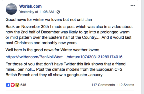
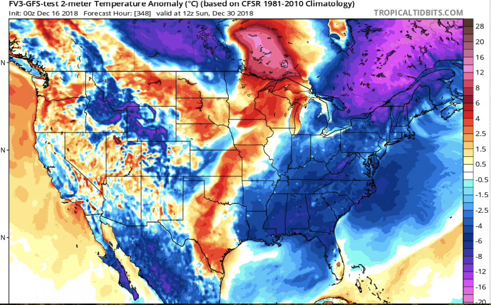
Fv3 00z Christmas and end of the month. Obviously still far out but i'll take it, it had held onto this idea for a couple runs now
-
-
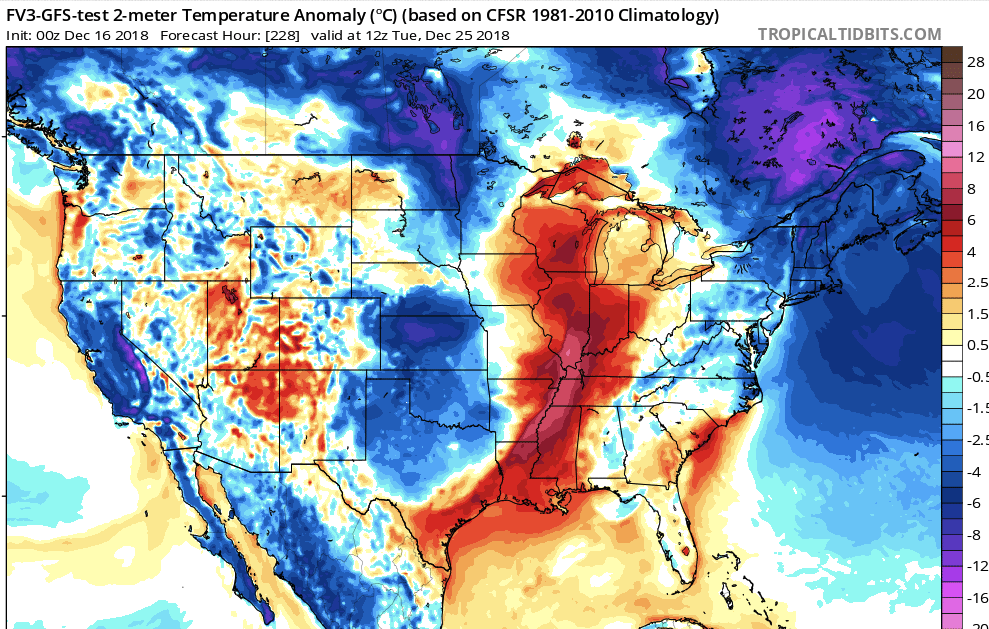
Definitely will be a warm-up between now and Christmas it looks like. But According to the FV3, that pattern won't be locked in. Still over 10 days out but FV3 has been pretty consistently bringing the cold back at/right after Christmas. And just for kicks, I'll post the end of the Fv3 run so grain of salt here (but i will say Fv3 has been consistent with the cold returning towards the end of the month too)
Fingers crossed

-
-
-
Reminder that the disturbance will finally move onshore on the west coast around 3-4am EST tonight/tomorrow morning. I'm not getting my hopes up for a major change to the forecast, but it will be interesting to see if there's any shifts either way once we get some observations fed into the models
-
9 minutes ago, nj2va said:
It’s going to come down to the strength of that confluence. If models are overdoing it or it ends up further north by 50-100 miles, then its game on around here. That stuff could easily change within 78 hours, let alone 100-120 hours out.
Exactly. Especially since the system is still a little over 24 hours from even coming onshore on the west coast.
-
1
-
-
DT update
-
Just now, midatlanticweather said:
The phase idea seems less and less likely... it was the Hail Mary for us weenies.. and, like Lucy taking the football away, it is less and less likely!
Here is the deal:
- Been great to have a threat! Southern streams are so wet and this will be a doozy of a system
- Thank goodness this is even before the start of Meteorological Winter. I will hate looking at % of normal snow for the season and be far less than south
- We have time! Hoping long range gives us more hope.
There is probably going to be a north trend, but that wall has to come down.. it may really hurt or be a 30 minute ride to see a lot of snow!
See y'all at 11
I agree. 18z so I'm not throwing in the towel yet. But there does seem to be a growing consensus on how far to the north models will bring this system. Luckily, winter has not even started yet and we will still have plenty of storms to track. Will be useful to compare model performance on this storm for future threats later on (especially FV3).
-
-
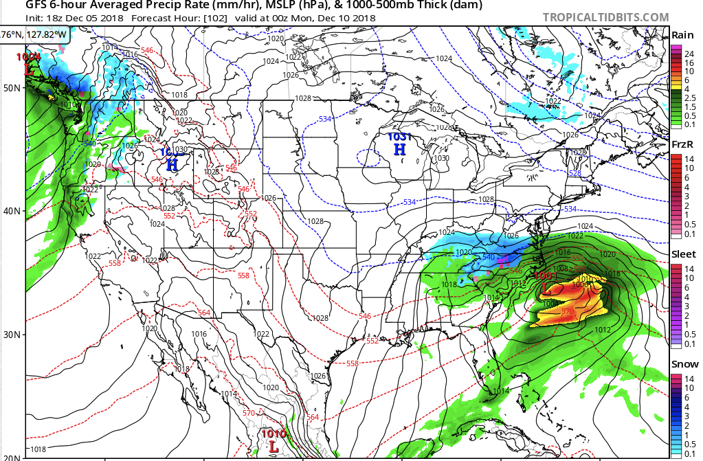
A miss on the 18z GFS. Snow doesn't get further north than Richmond.
-
Just so i know which thread to follow tonight...so anything storm related from now until the (potential) storm is on the Storm Mode thread just created, and anything on December outlook in general will be on this thread, correct?
-
1
-
-
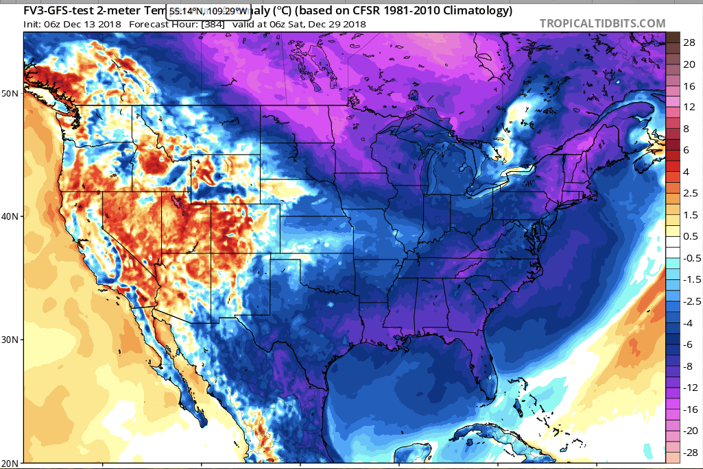
Looking ahead to the warm-up and Christmas, it looks like whatever warm-up does occur will be relatively short-lived. a little over a week perhaps
-
1
-
-
big improvement over previous GFS runs, but only one run. Let's see if this holds and if FV3 can stay the course as well.
-
1
-
-
Just now, snowmagnet said:
I keep reminding myself that energy isn’t even on the west coast yet. Anything can happen.
Right. Although the models seem to be focusing on central VA/NW NC, the energy won't arrive on the west coast until late thursday/early friday. Once that happens with observations can get fed into the model and there will (hopefully) be much more agreement/consistency
-
1
-
 1
1
-
-
I want to see the Fv3 before I begin to accept this will in fact be a southern slider
-
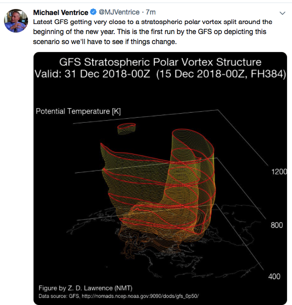
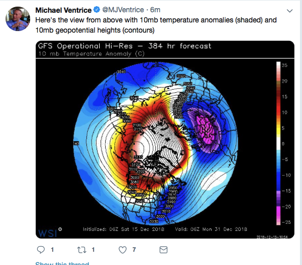
Don't know if this was posted here yet but this pretty much sums up what we've been talking about for a while.
Once these storms move on shore we can finally get some more accurate observation data fed into the models and maybe have some more consistency in these model runs.
-
2
-


December/January Medium/Long Range Discussion
in Mid Atlantic
Posted
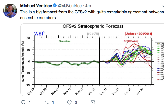
Capital Weather Gang also coming around on the cold/storm January idea: "Polar vortex could unleash winter wallop by January" https://www.washingtonpost.com/weather/2018/12/17/polar-vortex-could-unleash-winter-wallop-by-january/?noredirect=on&utm_term=.9075473f0ad4