
Zach’s Pop
-
Posts
88 -
Joined
-
Last visited
Content Type
Profiles
Blogs
Forums
American Weather
Media Demo
Store
Gallery
Posts posted by Zach’s Pop
-
-
4 hours ago, SnoSki14 said:
What do you make of raindancewx's analysis, he's basically comparing this year to 97/98 and shows everyone torching in January.
I think raindancewx has smoked one to many peace pipes in his day.

-
 1
1
-
-
4 hours ago, Hoosier said:
If my research is right, Boston has officially gotten 40"+ in a 21 day period in just 7 different years (1978, 1994, 1996, 2003, 2005, 2011, 2015). Tells me 2 things... it is not that common but Boston has been spoiled rotten recently.
Yes I realize it is rare. But January and February have always been favored for the northeast to be the snowiest months of this El Niño. For raindancewx to be pounding his chest on December 17th and comparing this El Niño to 97-98 is laughable and stupid.
-
1
-
-
3 hours ago, raindancewx said:
It may resemble a Modoki La Nina, where Nino 3/ Nino 1.2 is warmer than 3.4...which is essentially a colder version of 1997. Hence the map looking close. I'll be here while you guys find a better El Nino match to Dec 1 to Dec 15. Go on. I dare you. Here is the link - https://www.esrl.noaa.gov/psd/data/composites/day/

It sure as hell doesn't look like 2002, 2009 or any of the other Modoki El Ninos in December.


It actually is similar to 1997 in at least one way - the right circle is warmer than the left circle. That's not a Modoki. Look at 2009 for comparison.
I'd call it six weeks in a row of looking like 1997 at this point.

How is that bottom 20 snowfall in Boston back to 1892 through 12/16 working out for you so far? At this point, 1997-98 would be a massive improvement for Boston for snowfall, already over four inches by this point in 1997. The low-solar El Nino average for Boston, in years with under an inch through 12/15 is 30.5" back to 1892, and only one year got to over 40". I'm still waiting on your response as to what you'll do if the NE is warm in December like I've been saying since October because the first CPC warm wave has verified pretty well, and they have more coming.

Boston could get over 40” of snow in a three week period easily this winter. In fact I bet they do. Hopefully Albuquerque gets 4” of snow the entire winter.
-
1
-
-
2 minutes ago, CoastalWx said:
Put it this way, I don’t think one person has an overall +AO and a SE ridge nina circulation in the last third of December. That did show up in guidance and yes you have to look at models for that. You adjust. However I think the longer term still stands. Hope I’m not wrong.
If you are wrong you are out of my will son.
-
 5
5
-
-
2 hours ago, Isotherm said:
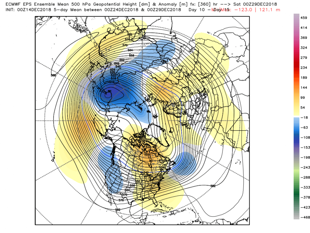
Well, since you inquired, here's what I posted on another board a few days ago. Very little change from previous thinking. Transitional period 21-22nd with neutralizing temperatures, followed by a sufficiently cold pattern to produce winter threats thereafter. There will be a temporary suppression of heights in the W US via the diminutive -MT/FT pulse in the 24th-28th period, but it will be countervailed by higher heights in the NAO domain, yielding a zonal flow (i.e., no significant ridging in the East). Note recent runs continue to correct w/ higher heights in W North American and the NAO domain, and this will continue, as a function of momentum alterations and vertical wave driving/strat changes. By the end of December, changes continue will a more Nino-esque Pacific structure developing.
The medium range pattern in late December is multifactorial, and the provenance of the depictions seen on model data are as follows:
1. There will be a relatively insignificant extratropical contribution of -MT in about a week, which aids in an ephemeral Pacific jet retraction.
2. The intraseasonal/MJO signal currently in phase 3, precluding full-entrance into GWO p5 right now, will be in the decay/coherency loss phase in late December, but will also aid adjunctively in the ephemeral jet retraction ("Nina-esque" interlude)
3. However, contemporaneously, the ongoing tropospheric forcing/MT/AAM induced stratospheric displacement event is inducing severe model volatility and rendering NAO/AO domain geopotential height forecasts quite inaccurate. Note the robust blocking signal in the NAO domain on the 23rd/24th (not detected a few days ago), which is rapidly lost by Christmas on the EPS. This is apocryphal in my opinion. The z150 vortex will be pushed into Siberia by the 23rd-24th w/ significant height rises in the southern AO/NAO domains. So, this correction will continue.
4. The diminution of the MJO signal as we approach Christmas, and the concurrent reinvigoration of the walker cell induced CPac. forcing, will force the GWO back toward p5 toward very late December. And as the strat. event realizes, all the putative dominios align, with a more classic Nino-esque Pacific structure near the end of month/New Year.
What does this mean sensible weather wise? I'm sensing quite a bit of worry regarding late December. There will be a transient momentum loss induced jet retraction which retrogrades the mean trough axis in the CONUS, but, concurrently, the AO/NAO domain geopotential heights will be more positive than currently progged. And therefore, the SE-ridge will not be as robust as some modelling indicates 25-28th. The flow will go more zonal for a period of several days (if you want to call this "gradient", but I dislike the word) as the momentum flux alters.
Nothing else has changed regarding the "transitional period 21st-22nd", with the pattern conducive for a threat thereafter.
1 hour ago, Maestrobjwa said:Okay...so, now somebody give me a non-cynical translation of it...lol
Read Tom’s thread in the general weather section. The guy is BRILLIANT. The reason the models are beginning to look less hostile in the LR is the very reasons he said they would a week ago. If you listen to anyone on the weather boards, Tom is the guy to follow
-
4
-
 1
1
-
-
2 hours ago, SnoSki14 said:
In no way shape or form will this season be remotely the same as 97/98 aka the strongest Nino on record.
Current atmospheric state still resembles a Nina.
He gets delirious in his efforts to make Boston look like the Fiji Islands this winter. Comparing this Niño to the strongest on record is laughable and really only strengthens the argument he doesn’t know what he is talking about
-
2
-
-
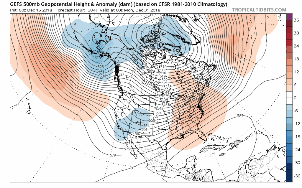
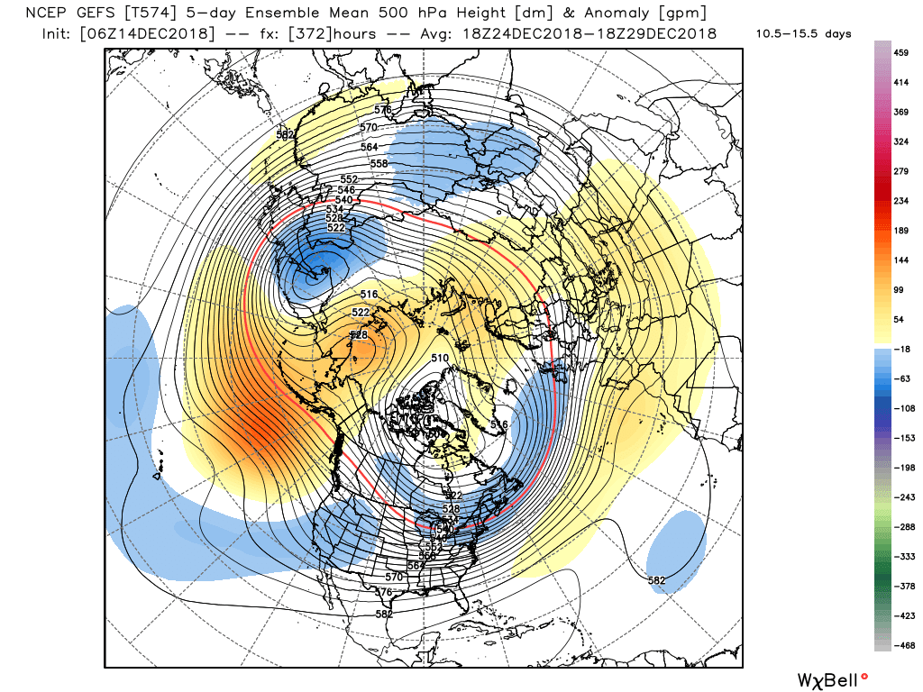
Last four runs of the GEFS. Tonight’s 18z GEFS beginning developing a east based -NAO which in turn starts to squash the south east ridge. Look for that to continue in the next week or so and while there will be a bad period for a bit, it won’t be the doom and gloom scenario some have painted.
-
4
-
1
-
-
2 hours ago, dendrite said:
This ridging can't stay (but baby it's warm outside)
It's got to go away (but baby it's warm outside)
This evening has been (maybe a front will drop in)
Completely torchin (maybe we can make some ice?)
Metfan will start to worry (The models always hurry)
Zach's pop will be pacing the floor (Maybe it won't snow anymore)
This warm air must gooooo
Baby it's warm outsideLol, more good stuff.
-
2 hours ago, CoastalWx said:
Torchmas... the rains coming down....
Torchmas.... I’m watching it fall...
2 hours ago, CoastalWx said:Just see the seasonal forecasts turn into doggie poo.
C'mon It’s lovely weather for a burly man or two.
Giddy up giddy up giddy up this blows..
there’s no phucking snow...
not even a pile here to show....
Lol, good stuff.
-
1 hour ago, CoastalWx said:
I laughed. It’s all good. We all like snow. Happy holidays.
Same to you Scott.
-
3....... 2........1.........
until someone posts and think I was serious blaming Scott.
-
1 minute ago, CoastalWx said:
How is a warmer east have anything to do with GW?

I blame you, not GW.
-
1 minute ago, 40/70 Benchmark said:
Hope Zach's Pop is enjoying..
42 with drizzle. This torch sucks
-
1
-
-
2 minutes ago, dendrite said:
Chance of an angry, racist post: 80%
Wut??
-
8 minutes ago, OSUmetstud said:
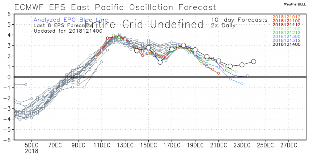
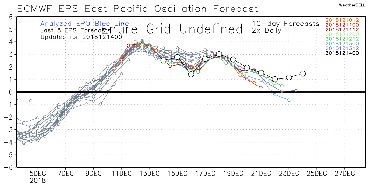
The eps doesn't have an -EPO from what I can see. You have any thought on that?
 5 minutes ago, OSUmetstud said:
Versus this.

Interesting. I was told the GEFS caved to the EPS. Not sure I see it
-
1 minute ago, Ginx snewx said:
Chill
I noticed the mets on here are very very sensitive. They like to dish it out but get agitated when a past forecast gets brought up.
-
59 minutes ago, ORH_wxman said:
GEFS there totally caved to the EPS gradient idea.
Squeal like a pig Zach's Pop and call Coastalwx your daddy.
Really? Your buddy said close the shades for two weeks and some of you may see snow and ice next week. Sadly your EPS hugging buddy will miss it since his shades will be closed
-
-
3 minutes ago, LurkerBoy said:
Yo...the fact that any of us are wasting our time on this website makes us all weenies.
The fact that some on here love using that term for the less experienced is a weird thing that is a tool of social positioning that is most commonly seen in middle school boys. It is used to make yourself feel better about how little you know/can control. A big boys weather club!
Scott, you whiffed this one while the “weenies” who remained optimistic were correct. I’m sorry if this pokes a hole in that very visible ego, but thems the breaks!
god bless us one and all
The very same ones calling you a weenie are the ones who have epic meltdowns when they don’t get snow or bitch because they only got 16” while another town over got 20”
-
18 minutes ago, CoastalWx said:
You do realize the GEFS moved towards that right?
As I stated numerous times, it's a relaxation not a torch. Yes close the shades because the pattern starting a few days ago is hostile to snow. Myself, Will, Don S and multiple people have said this. Post 12/25 and even that isn't a given. Keep the faith though I guess.
At the end of the run maybe but not around Christmas. You beloved EPS keep dumping a trough into the SW in the 15 day period than back off as it moves up in time. Did it again last night. Sorry you can’t admit that but hug away. Many ensemble members run storms up the coast and have no gradient look unless you want to call east vs west a gradient. And while all this is going on the PV is getting attacked daily and how that plays out will be the deciding factor on late December and early January.
-
1
-
-
Just now, CoastalWx said:
Enjoy the rain, it's the only rain you've got.
Enjoy your EPS. It’s the only model you look at.
-
15 minutes ago, CoastalWx said:
Euro wants none of the GFS next week and it seems like the 6z took a step in the direction. Still time for that, but right now I wouldn't expect much at all. At least we thaw out for a few days.
1 minute ago, CoastalWx said:We already have gone through this. You still don't get it.
You were closing the shades for a couple of weeks. Now in your own words it’s a few days of a thaw. It will be ok son. Maybe Santa can bring you a new subscription to The EPS. Are The Really That Good??
-
1
-
-
1 hour ago, SnoSki14 said:
Let me know how that works out for you.
Truth be told I'm not sold on a gradient pattern, GEFS don't really see that and it would be very unusual to have it during a Nino.
But if there is one, then it could just as easily torch those further north especially if the troughing sets up out west. I'd be comfortable if I lived in VT or ME.
There won’t be one. Model huggers are struggling right now because the EPS, which was dumping the trough into the SW is now leaning away from that. It is changing and once it gets to where those who have nailed the pattern have said it will. There will not be a southeast ridge and the gradient talk will be all gone, just like the two week torch pattern is now called a few day thaw. Model huggers are struggling right now. Going to be a tough few weeks for them
-
Just now, CoastalWx said:
They all do
I don’t what shocks me more. A gradient pattern in an El Niño or you looked at something besides the euro


December Discussion
in New England
Posted
Lol, the guy is comparing this Niño to 97-98. There is NOTHING remotely similar and he fails to see that. And did you see his call last winter? If you reverse his map he nailed it. For some strange reason his forecast for New England is the same as last year, mild and dry. He really isn’t worth engaging