

Toekneeweather
-
Posts
107 -
Joined
-
Last visited
Content Type
Profiles
Blogs
Forums
American Weather
Media Demo
Store
Gallery
Posts posted by Toekneeweather
-
-
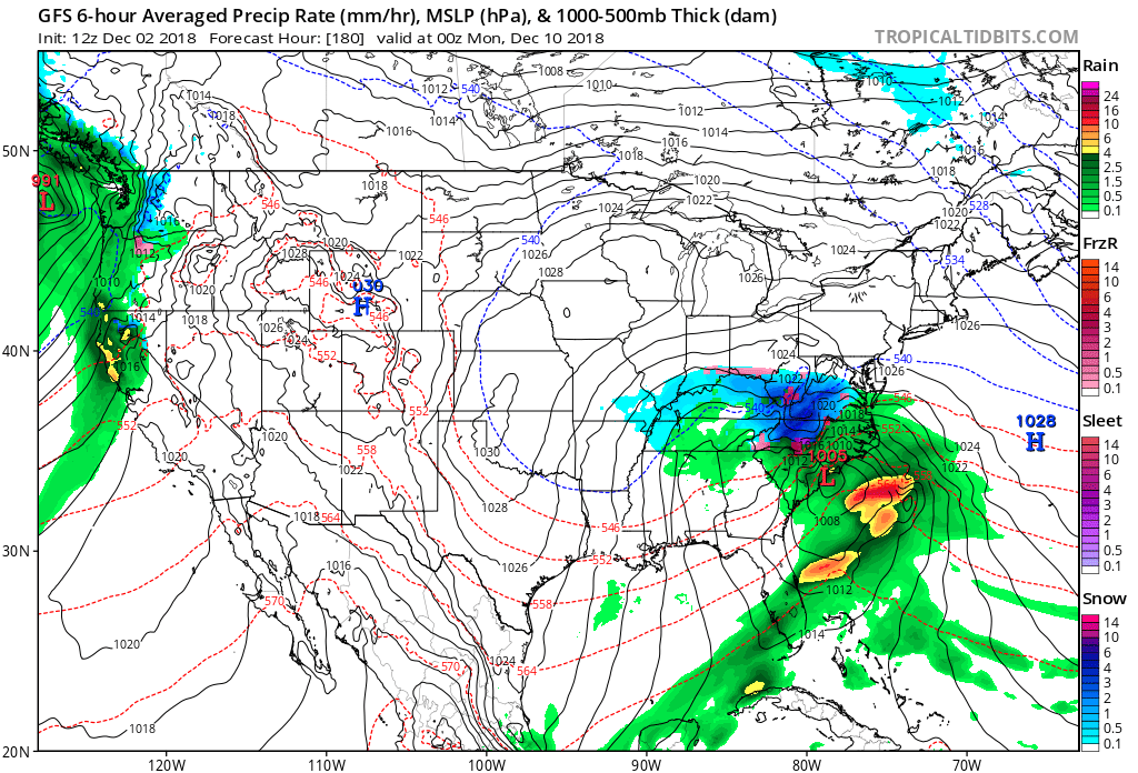
Gfs para 6z is a hit!
-
Just now, Ericjcrash said:
GFS so far south a blend wouldn't be enough lol
I like the gfs para if it stays south I’m going to get a bit worried but if it trends north we’ll you know it .
-
 1
1
-
-
Just now, Rjay said:
Vs this
Let me ask you guys something... would you rate the gfs or Canadian higher?
January 4th snowstorm last year Canadian hunted it before anyone else
-
Just now, Snow88 said:
Uh? CMC is north of 12z and is a coastal hugger.
You’re right I’m sorry I’d take that run right now
-
Just now, USCAPEWEATHERAF said:
I will get snow eventually
You’re going to get one of those blizzards and we’re missing everything. I need snow now James I’m feening!
-
2 minutes ago, Ericjcrash said:
If I was in SW VA I'd be on cloud 9. They are as close to a lock as there could be this far out. Wiggle room either way.
Lock? We’re 7 days out... 6 for them come on when is day 6 a lock!
-
2 minutes ago, dendrite said:
Stay safe.
4 minutes ago, USCAPEWEATHERAF said:I'm still watching Wednesday night into Thursday for some flurries
Times are rough huh James ?
-
 1
1
-
-
I’m

-
 1
1
-
1
-
-
My thinking right now.
-
1
-
3
-
-
-
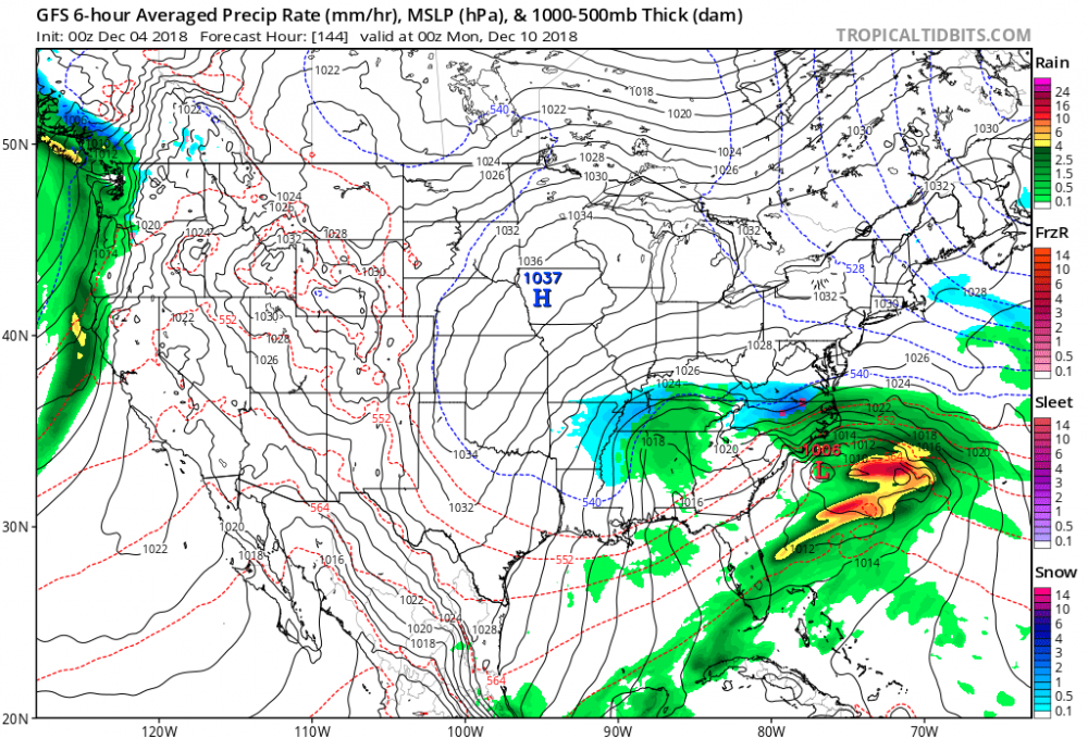
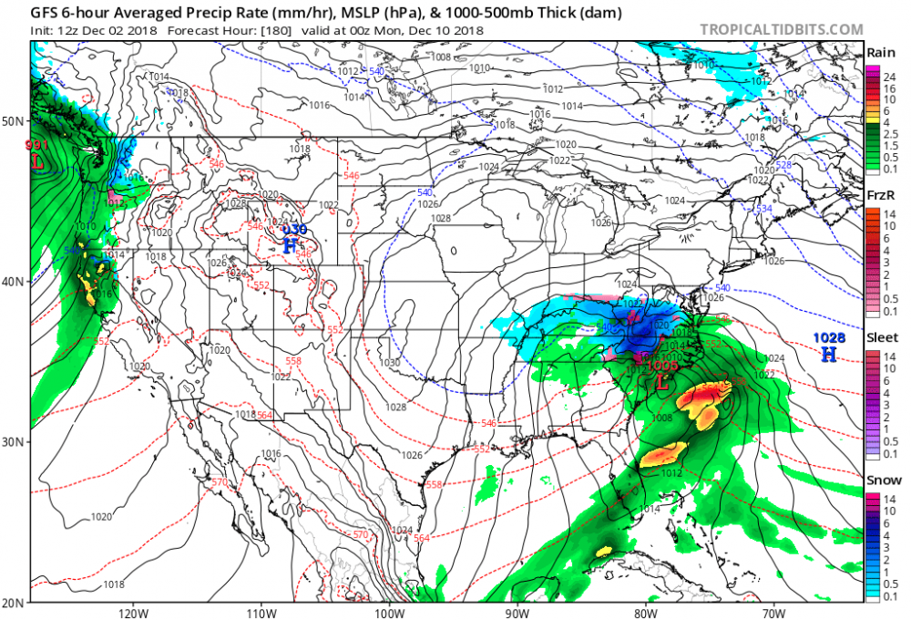
If I ever wanted to see a model look 144 hrs away I would choose this!
-
This reminds me of January 23rd 2016. Id love someone to pull out the euro and GFS runs from 6-7 days before the storm hit
-
It’s very far off timing wise so I wouldn’t worry about it too much. I’d make a full time investment on this storm if Thursday comes in snowy if not than I’d give up on it entirely. Euro is definitely not far off just the main cold kinda leaves by the time the low has an movement north.
-
1
-
-
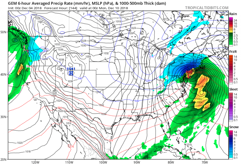
How’s the euro look any northward movement?
-
2 hours ago, Snow88 said:
Icon is also north but rain
Gfs is slightly more north but I'm not expecting it to trend northward yet .
Gfs is the worst model it’s pronably worst than navgem
lets just say the euro looked a lot better than its previous runs
-
1
-
-
4 hours ago, NEG NAO said:
just ask yourself - how many systems were suppressed this season so far ? The answer is obvious.....
I was just going through the latest GFS para and GFS and to me it looks like plenty of opportunities. They all miss as of right now but I counted about 3 strong systems that are coming east, how far north they get is up to Mother Nature but we need to just take a step back and realize that we have so many storm chances to close out this obviously record precipitation year. It’ll be decently cold after tomorrow so chances will start rolling in. It won’t be so cold so I don’t think suppression will come in but the blocking could make it drier. But if we do get hit, we will get a good hit!
and winter doesnt begin for another 3 weeks roughly.
-
2 minutes ago, Snow88 said:
We have been through this many times
Models overdo the confluence until it gets closer.
I don't see how there will be a lot of confluence to squash this.
Luckily we’re so far away that there’s plenty of time for this to change! By Tuesday I would really look elsewhere if were still looking at suppression
-
1
-
-
46 minutes ago, ForestHillWx said:
I'd like to see some semblance of high pressure in Quebec. Without it, I'd worry whatever cranks in the southern stream will cut. Apps runner or sorts.
Yeah this isn’t cutting, the confluence will keep pushing this down south. Exactly what’s happening with the euro run. Suppressed to the max
-
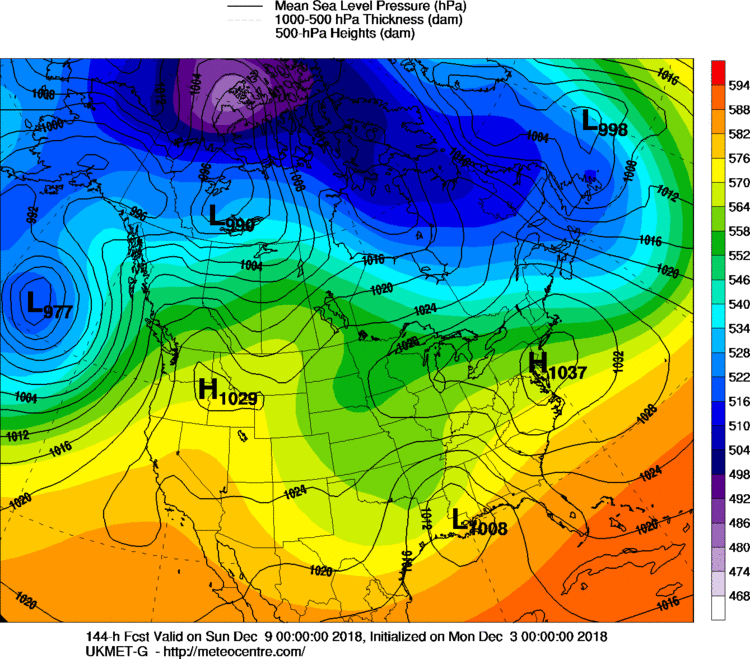
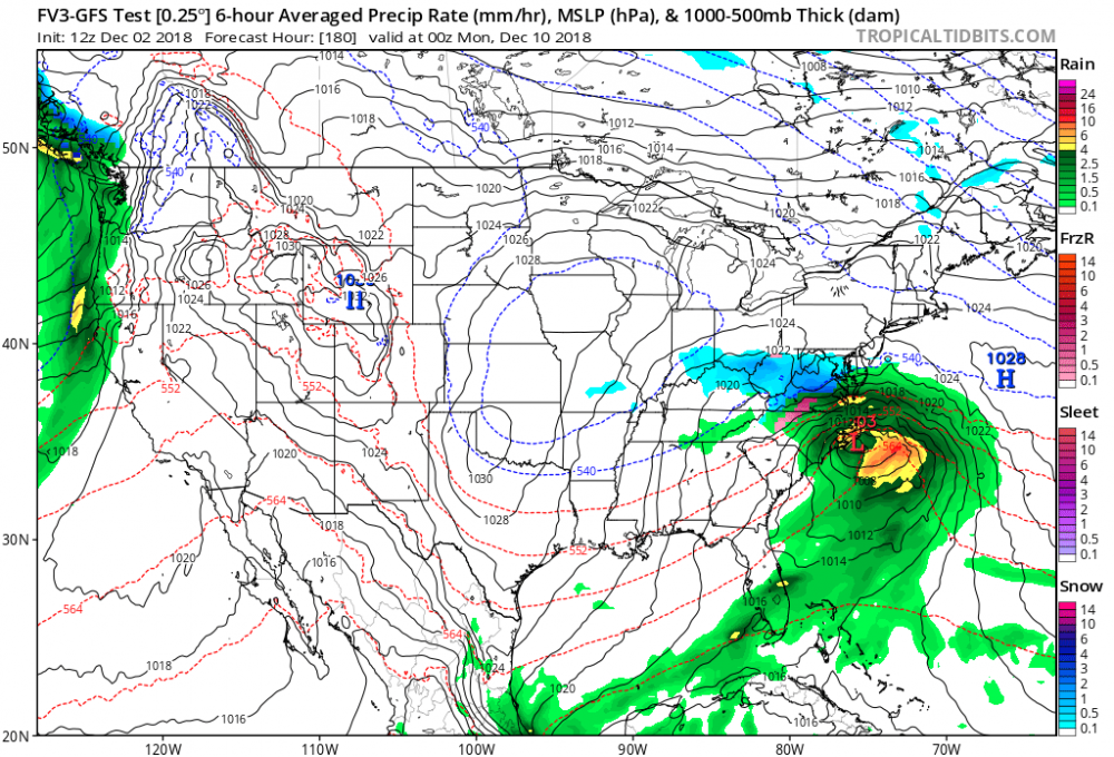
Gfs para is suppressed again. I would think that high in the Atlantic would actually help bring the low more north. We’ll have to keep an eye on that squished high pressure if it has enough pressure to make our low pressure run up the coast instead of going out to sea like the GFS para is showing. The gfs and cmc had that idea a bit more than the gfs para.
-
Gfs and cmc look better definitely still a bit suppressed and warmer than I’d like to see but it’s so far away that those details don’t even matter. I’m more interested in what the GFS para is going to depict and of course the euro
-
1
-
-
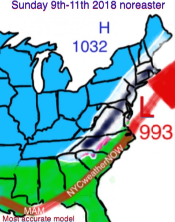
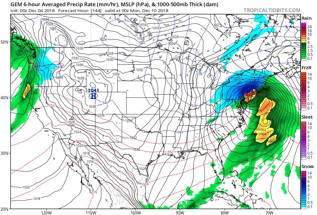
Both GFS and PARA GFS were suppressed and missed south big time for next weekends system
-
T
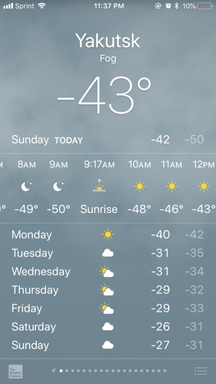
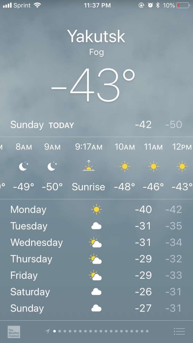
14 minutes ago, LibertyBell said:Yaktusk can get to 100 or higher in the summer and down to about -80 in the winter. The spelling of the other cities depends upon the translation, they use J and Y interchangeably, I've seen it spelled with a J too. That city gets to 90 in the summer and the lowest I have them listed for is -98 in the winter. Verkhoyansk has gotten close to 100 in the summer and -90 in the winter.
I haven’t seen Yakutsk ever at -80 but I’m sure they’ve hit. Yakutsk did hit 101 in 2011 all time high. But it doesn’t hit every year. It does seem to have 90’s every year. I would love to visit that city during the summer though for some reason. The two small cities you just mentioned hold for two of the coldest temperatures in the northern hemisphere
coldest:
Oymyakon reached −67.7 °C (−89.9 °F)
2nd coldest:
Verkhoyansk −67.6 °C (−89.7 °F)
by the way para gfs was suppressed for next week.
-
1
-
-
46 minutes ago, LibertyBell said:
Thats a famous city- the one with the record for being the coldest city in the world and the one with the largest temperature variations.
Two others that are close by, but are considered towns and not cities and are even colder, are Omyakon and Verkhoyansk. Look at their temps too.
It’s Oymyakon and I think most times Yakutsk has the coldest temperature before the rest of these smallercities or towns. It tells me it’s going to get really cold soon. Yakutsk must be a beautiful city during the summer. Crystal clear blue skies with a nice breeze with many days reaching into the 80’s
-
It should be -50 in Yakutsk Siberia Monday morning their time just before sunrise around 9:17am
ive been paying attention to this city’s temperatures for a long time probably ten years and I don’t ever remember it this cold & this early. Another 20 days really of having less sun and it than it finally starts retreating back. Of course for us we gain day light but some of these cities don’t have sun weeks and possibly months after winter solstice.
-
1
-


December 2018 General Discussion & Observations
in New York City Metro
Posted
Gfs through 72 hours is definitely north of its same time with the last run. Let’s see how it finishes?