
Gorizer
-
Posts
274 -
Joined
-
Last visited
Content Type
Profiles
Blogs
Forums
American Weather
Media Demo
Store
Gallery
Posts posted by Gorizer
-
-
Albany/Schenectady numbers are dropping like the Christmas Eve stock market did.

-
16 minutes ago, OSUmetstud said:
mine is weatherbell (JB) and the other is weathermodels.com (Ryan Maue). Could be some slight differences in calculation.
It's a H-U-G-E difference in calculation for Schenectady County. Holey moley.
-
20 minutes ago, wolfie09 said:
It may be hidden in the "model lab"

::comes in off the ledge:: lol
-
10 minutes ago, OSUmetstud said:
")
Oh, and i'd sell the 21:1 ratios in BUF.
Euro says, "fork you Capital District!" I may have to take a road trip west.


-
52 minutes ago, Thinksnow18 said:
How do I like this 1000 times???
Congrats central and western NY. You guys are gonna jackpot!
-
1 hour ago, CNY-WXFREAK said:
Sleet or any kind of mixing isn't making it to the Mohawk Valley, no way no how. The furthest it gets would probably be a line from KPOU to KBGM if it even gets that far.
We’ll just have to see. KALY is disagreeing too now. I’m telling you, nearly every time they say “just south of here”, it makes it to the Mohawk line.
“
.NEAR TERM /UNTIL 6 PM THIS EVENING/...
As of 940 AM EST...Warnings are out as we are in the calm before
the storm. Latest guidance coming in has shifted a bit further
north with the mid level warm nose which may result in a bit
more sleet and/or freezing rain.”
-
1 hour ago, Kasim Awan said:
Hi, would you guys say Glen Falls is up for a good amount? I know it wont get the highest totals but I am here stormchasing. Wondering if it's worth taking a last minute jog north westwards to somewhere a bit further from the freezing line at 5,000ft. The system seems strong with a more northerly track as a result. Feeling a bit unsure about my location.
I don’t think I’d move. There’s a small chance pingers could make it up the Hudson Valley as far north as the Mohawk River, which could include Amsterdam. Glens Falls is far enough north to be safe from that.
-
 1
1
-
-
7 minutes ago, 96blizz said:
For the sake of the workers and nutty fans they’d be wise to proactively postpone.
It’s a 2pm tip, so the impact shouldn’t be that bad.
-
9 minutes ago, CNY-WXFREAK said:
All models have initialized to cold with conditions at the surface and the system ticked NW again so KALB is seriously now in the cross hairs of screwing with IP/SN but I doubt any ZR but it may cut down on totals!
Yeah, as I mentioned previously, that over running almost always exceeds modeling around here. I may escape serious damage here in a Delanson, being north and west of Alb, even though I suspect we’ll ping for awhile, but Albany proper may lose several hours of peak snow time.

-
15 minutes ago, wolfie09 said:
Rgem is more euro like now in track..Last run it was in nnj..


Still with that taint right to my doorstep.
-
8 minutes ago, mattny88 said:
i think for giggles and as a friendly contest...we should all create our own snow maps and see who ends up closest to the tallies that will come from this storm
BUF- 7
Roc- 17
Syr- 18
Ithaca- 17
Tug- 16
Albany- 19
-
7 minutes ago, mattny88 said:
i think for giggles and as a friendly contest...we should all create our own snow maps and see who ends up closest to the tallies that will come from this storm
I just submitted 18.6 at Albany Airport in an office pool.
-
4 minutes ago, wolfie09 said:

So it seems the Euro keeps the taint well south & east of the Capital District. My head spinning. But I guess it is for all of us really. What a yoyo week.
-
So I gather from these latest runs that the chances of taint reaching Albany have gone up. We'd been in the bullseye too long. Something had to give.
-
7 minutes ago, vortmax said:
From WPC diag disc:
Preference: Non 12Z NAM blend
Confidence: Slightly Above Average
Model clustering continues to slowly tighten with each cycle, such
that confidence is a bit above average for the track and evolution
of the upper trough and surface low moving from the central to
eastern U.S. this weekend. However, the 12Z NAM stands out the
greatest from the relatively tight model clustering with its
surface low tracking faster/east compared to the remaining
deterministic and ensemble consensus. This is due to a slightly
flatter low-mid level wave in the NAM. The 12Z NAM also differs
with its 700 mb evolution across the Ohio Valley on Saturday with
a less consolidated wave. While the 12Z NAM is not a significant
outlier, there is enough difference to exclude it from the overall
preference across the central and eastern U.S.
Would have been perfect if they just ended their statement with... "It's just the NAM being the NAM."
-
 1
1
-
-
13 minutes ago, Stash said:
If the low crosses the lower Hudson valley as depicted in the rgem, then we will sniff sleet for a little bit. I usually use the rgem as my last bastion of hope during SNE snowstorms where I'm on the outside looking in. Usually quite amped. If other guidance follows suit then will certainly be worth considering.
Thanks Mike. We'll see if the GFS and Euro make any shifts then I'll make the call.
-
22 minutes ago, CNY-WXFREAK said:
From DR. Maue site, a blog post!
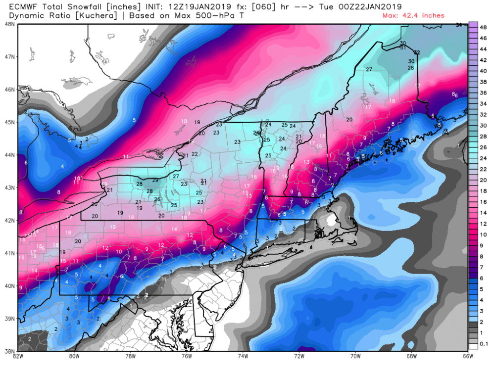
That has to be the Euro for sure so there you go Gorizer so not far off from the Rgem in fact, so something to watch as we get closer.
Keeps Albany airport in the clear, as it's in the northern part of the county, but perilously close.
-
1 minute ago, CNY-WXFREAK said:
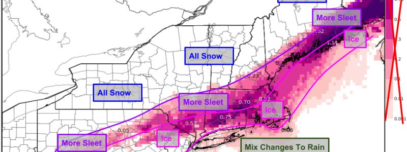
Well if you go by this run you guys mix in the Capital district but I ain't going there yet but man, thats a lot of warm air being drawn up from the Gulf!

Wow. I think the RGEM is all alone with that much of a warm fetch. Although experience here is that the warm over running most time exceeds what is modeled.
-
So I have to submit an estimate for a snow pool at 2pm today. Closest to the tenth of an inch without going over at Albany Airport. I'd be interested in any thoughts from you guys. I'm thinking somewhere around 20, but naturally I'm waiting on the 12z runs before pulling the trigger.
-
32 minutes ago, BGM Blizzard said:
Yeah Capital District has been sweet spot on most of the model outputs that I've seen thus far. I foresee jackpots in the high terrain along the I-88 corridor.
That would be my driveway.

-
3 minutes ago, TugHillMatt said:
Wow, you eastern Upstate guys are a patient crew. Haven't seen you guys on here until your first real winter storm.
") You will be able to show off your snow pics to those of us in the snow belts.
You will be able to show off your snow pics to those of us in the snow belts.
The Capital District... the snowbelt's ugly step child. LOL.
-
1
-
-
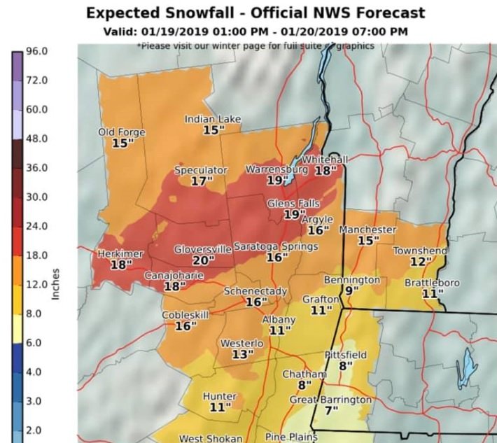
Looks like Albany/Schenectady area does well no matter which is right. Further south reduces the taint risk here at least.


Upstate/Eastern New York
in Upstate New York/Pennsylvania
Posted
Good for you Ottawa. You've had your share of synoptic screwings up there!