
Gorizer
-
Posts
274 -
Joined
-
Last visited
Content Type
Profiles
Blogs
Forums
American Weather
Media Demo
Store
Gallery
Posts posted by Gorizer
-
-
First flakes have arrived here in Duanesburg.
-
1 hour ago, Ericjcrash said:
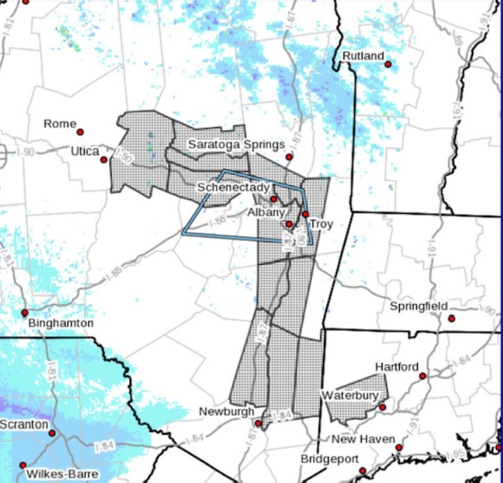
116 PM EST Sat Jan 15 2022

...WINTER STORM WATCH REMAINS IN EFFECT FROM SUNDAY EVENING
THROUGH MONDAY EVENING...

* WHAT...Heavy snow and mixed precipitation are potentially
  possible. Total snow and sleet accumulations of 4 to 12 inches
  and ice accumulations of a light glaze possible. Winds could
  gust to 40 to 50 mph over the higher terrain.

* WHERE...Southern Vermont, southern Adirondacks, Mohawk Valley,
  eastern Catskills, Helderbergs and the Lake George northern
  Saratoga Region and Schoharie Valley in eastern New York and
  the Berkshires of western Massachusetts.
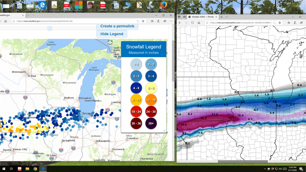
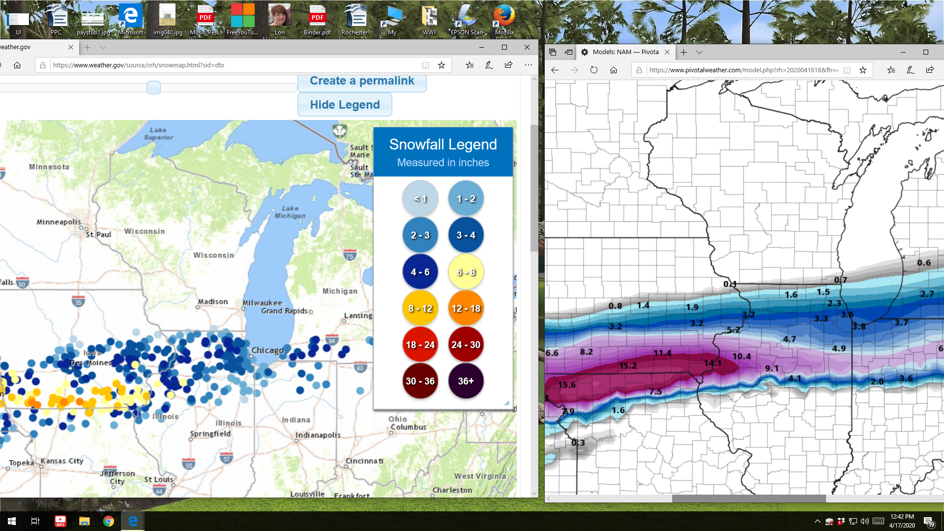
AKA we don't know if the NAM or Euro is right.
Also representing the Eastern part of the thread here. At about 1,500 ft elevation in western Schenectady County, I typically fall into the "Helderbergs" part of the forecast, and high enough to avoid any easterlies shadowing. Just worried about the taint at this point that could really cut that top end of the range down.
-
 1
1
-
-
2 minutes ago, BuffaloWeather said:
Yeah I don't get why snow depth people wouldn't want sleet. It will stick around longer than any snow will.
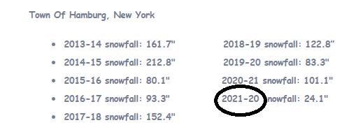
Hey, shouldn't this be: 2021 - 22 ?
-
1
-
-
52 minutes ago, 96blizz said:
You can’t make this shit up. Lol

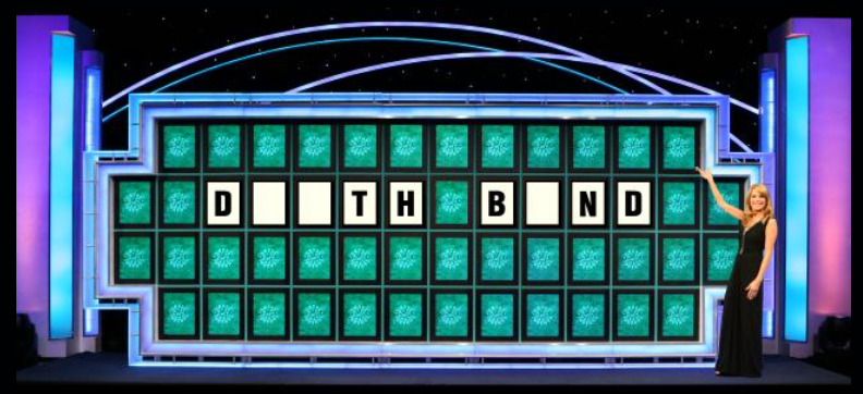
DEARTH band.

-
1
-
 1
1
-
-
1 hour ago, TugHillMatt said:
Especially when all the Canadians come out from hiding...
Darth Bond over Toronto???
-
2
-
-
38 minutes ago, 96blizz said:
The GFS is putrid for many.
I should never have quit drinking a year ago…
Ugh... toss it. Toss it quick. Put a mask on first then wash your hands Ugh.
-
3
-
-
4 hours ago, Blue Moon said:
You gotta fill me in on... whatever this is.
Who DARES to buy a vowel???
-
2
-
9
-
-
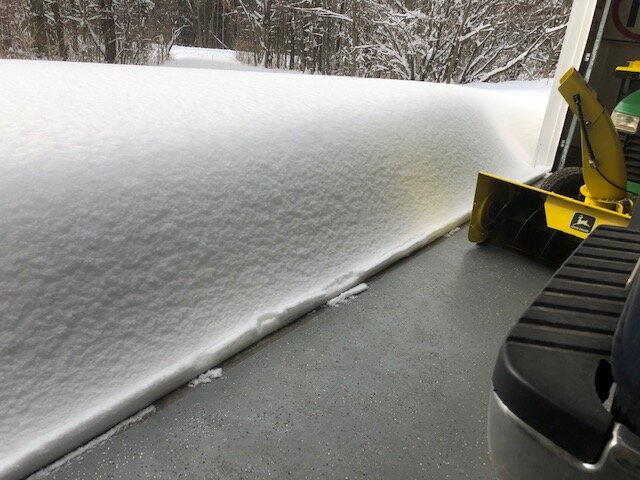
1 minute ago, rochesterdave said:
Love your snowblower. Which model JD is that?
GT 235. 18 horses. Had her nearly 20 years now. Runs as good today as the day I got her.

-
3
-
-
43 minutes ago, Stash said:
It can happen wherever the deformation sets up, but this is a relatively quick mover. Been in ENY more than 20 years now, and have seen at least 6 or 7 storms of over 20", in between all the whiffs, usually to the south and east. That number includes the back to back storms in 02/03, and two more the past two Decembers. I'm glad to see WNY getting in on the fun this time.
That's about right Stash. That dump one year ago December was a beauty. A bit over 30 in my driveway. Just lovely!

-
7
-
-
1 hour ago, LakeEffectKing said:
It's subtle, but the axis of heavier snow was modeled yesterday by the NAM to be a bit south of verification...
And accordingly, the NWS in Albany has just added these counties to the Winter Weather Advisory for 2 to 5 inches.
-
13 hours ago, Ericjcrash said:
Yeah, have a house in southeast Deleware county ~2000'
Off topic but... Glendale? I grew up in Glendale. 66th Street and 70th Avenue. From 1964 to 1980.
Cheers!
-
2
-
-
39 minutes ago, Kasim Awan said:
We're getting hammered by 2 inch per hour rates here in Ticonderoga and there's already 17 to 19 inches on the ground from this storm.
So my advice not to go to Amsterdam and stay put was sound! Glad it worked out for you! Amsterdam flipped to sleet for a couple of hours but is back to snow now.
-
1
-
-
50 minutes ago, winter_rules said:
In NW Delaware County we had about 9 or 10in by 3AM, then switched to sleet and freezing rain and actually reached 33° at some point this morning! Down to 23° now and back to all snow. This storm will provide a solid base on top of frozen ground for outdoor activities.
It was interesting because, for the past several days, the models showed us in a mix for several hours, just like what actually happened. However, most of the forecasts did not seem to acknowledge that possibility until late yesterday. It’s surprising because the warm air always seems to push a little farther north than the models show, and they were showing this for many days leading up to it. I have concluded that meteorologists must be eternal optimists just like snowmobilers and skiers!
Exactly right. I mentioned this yesterday that in eastern NY, the overrunning warm air almost always exceeds what is progged. Not only did it reach the Mohawk valley, but it streamed about 10-20 miles north of it.
We’ve just flipped back to snow here after a 4 hour sleet fest. Snowing moderately.
-
Well, after all the stressing, the party is over here. After close to 10”, we’ve gone over to pingers.
-
7 minutes ago, CNY_WX said:
Gorizer in Delanson looks to be getting smoked right now. It will be interesting to see his report.
Heavy snow. 2” in the past hour. Pouring down now.
-
1
-
-
Maybe Albany/Schenectady squeak by without the taint, by a hair? Gonna be very close. But at least there’s hope!
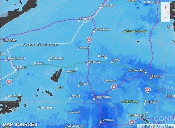
As of 1234 AM EST...Latest KENX radar and ground truth indicate
moderate to heavy snow is occurring across a large portion of
the Albany forecast area, as the strong baroclinic zone ahead of
the warm front is impacting the region. Some embedded laterally
transitioning mesoscale bands may be setting up documented in
the CSTAR research. We have an SPS out for some 1-2"/hr rates.
KALB has had 1"/hr hour snow increase group the past few hours.
Interesting, that the 00Z GFS has trended colder with perhaps
the ptype holding as mostly snow from KALB north and west
-
6 minutes ago, rochesterdave said:
Siedel is in Albany. He was just on TWC live and it’s puking snow on him.
Continues to pick up here. 1.6" in the last hour.
-
3 minutes ago, TugHillMatt said:
Albany area is looking good again.
We're in "inch an hour" rates now
-
1
-
-
-
Snow has really picked up in the last hour. 1.5 inches in the last 2 hours.
-
The models have not handled the low-level temperatures very well this evening and this will likely effect the track of the surface
low as it tracks across the northern mid-Atlantic late tonight. Temperatures have been colder than forecast especially in the upper
Hudson Valley and southern Adirondacks where readings have dropped down into the single digits to near zero.
The latest 00z NAM forecast is a bit farther south with the track of the surface low and is just a bit colder with its thermal profiles
than the previous couple of runs, however it would still support a change from snow to sleet as far north as the northern
part of the Capital District around daybreak Sunday. We suspect that when all is said and done sleet will mix with the snow
just about up to Saratoga Springs Sunday morning which will cut back on snow amounts from that area south.
-
Awful lonely being the only Eastern NYer in a forum called Upstate/Eastern NY.
 Very light snow here. Exactly 1" measured.
-
2
-
-
1 hour ago, CNY-WXFREAK said:
I can't believe the difference in track, nuts!
oRH goes over to plain rn, thats nuts!
To the mohawk river valley and beyond.
 Still extremely fine flakes. about a 1/2".
-
18 minutes ago, Buffalo Bumble said:
More snow pics, less man nipple shots please.
Anybody wanna see my 59 year old beer gut? Finally started snowing here. Fine as powder.

Jan 16-18th Major Synoptic Snowstorm- Observation Thread
in Upstate New York/Pennsylvania
Posted
Local Albany met says the coastal low formed 50 miles east of progged and bumped up accums in eastern NY up a few inches. Expecting 8 to 12 here now.