

Boonelight
-
Posts
54 -
Joined
-
Last visited
Content Type
Profiles
Blogs
Forums
American Weather
Media Demo
Store
Gallery
Posts posted by Boonelight
-
-
Just drove back to Deep Gap from work in Boone. There was more snow on the ground when I got to work this morning in Boone than there was when I left. Deep Gap barely has anything. My deck is white, and there are some patches of snow on the ground, but nothing like what I was expecting. It’s definitely cold enough for it to accumulate, and it did for a while, but it’s just not staying on the ground. 31° here in Deep Gap. We got a dusting at best, even in Boone. Better than nothing I guess.
-
Light flurries here near Deep Gap. It’s been on and off for the past hour, but seems to be steadier now. Only at 40°, hope that drops soon. Let’s go!
-
 1
1
-
-
On 3/3/2019 at 11:49 PM, Buckethead said:2 hours ago, MotoWeatherman said:
Flakes are flying again here on Beech. Super light but flakes non-the-less. Temp is down to 13 already. Snow flurries and snow showers should max out towards sunrise then end quickly in the AM.
Thursday night early Friday is looking...MEH.
19° here in Deep Gap. No snow, but I agree about Friday. Was looking forward to seeing some snow, but now it looks like ZR. This winter has been a rollercoaster, to say the least.
-
18 minutes ago, Buckethead said:
29°/29 and light snow falling. Everything is already coated, ground included.
That’s nice man! Hope you get some more. It’s 37 at my place, with nothing but rain earlier.
-
3 hours ago, MotoWeatherman said:
Nice you did way better than me at 4650 on Beech. LOL. Got about an inch of snow and then just freezing rain all night. Heaviest returns stayed south and east of me.
That’s crazy! We got a little ZR here but it was mostly a snow event. Unexpected, but welcome.
-
1
-
-
46 minutes ago, MotoWeatherman said:
Here comes the rain/snow line. It was fun while it lasted.
Yep, that’s moved here now. 2” of snow and now sleet.
-
5
-
-
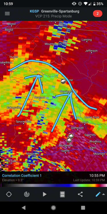
Fat snow coming down in Deep Gap. What is the consensus in the Boone area? You getting snow or ice? I thought this was supposed to be an ice event, but it’s been nothing but snow for us here off of 421 east of town.
-
Once again, it’s snowing here. Might be looking at 1.5” to 2” soon. I thought we’d be looking at freezing rain soon, but it’s still snow.
-
4
-
-
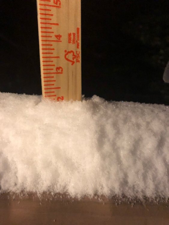
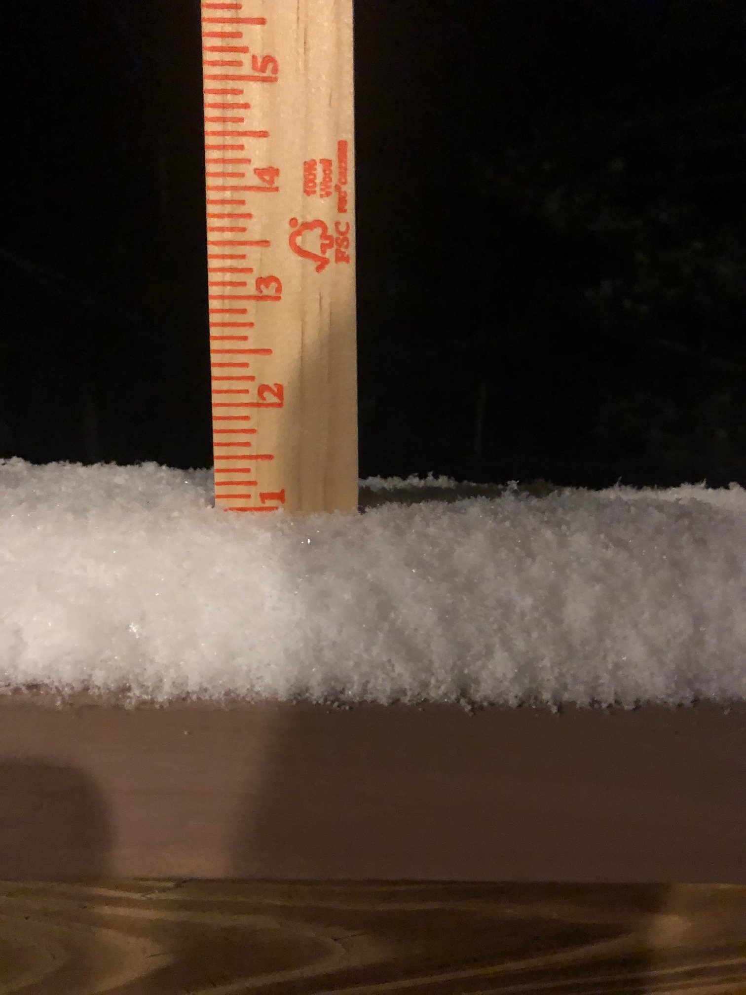
Almost an inch here in Deep Gap.

-
4
-
-
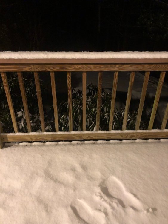
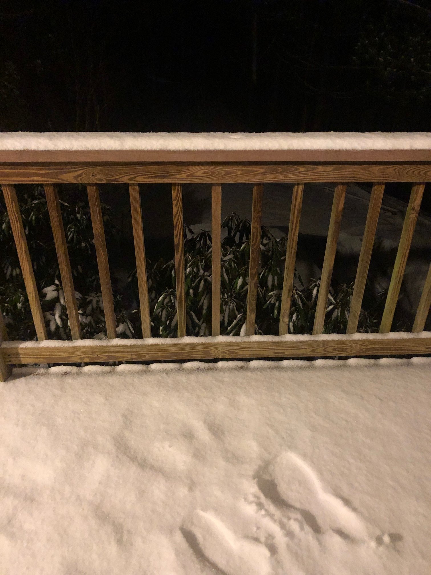
Checking in from Deep Gap! Just a little 1/4” of snow, but it’s coming down pretty good again now. My deck is white, which hasn’t happened in a while. We never got above 34 today, and it’s been 32 for a few hours.
-
This is officially the most snow I’ve ever seen in my life. We have 16” easy with some higher drifts, and it’s still lightly snowing. Just insane!
-
3
-
-
3 minutes ago, BretWheatley said:
Phew... I really can’t imagine that much more..
Big ol bullseye near my house near Boone on that one. I’d love to see that.
-
1
-
-
12 minutes ago, NC_WX10 said:
No not at all I always worry about the radar when it gets to gametime. and I'm out on 105 by the bypass.
Game time is here! Snowing, but really light. Small, diamond like flakes with a few larger ones mixed in. I’d lie to see some bigger flakes at this time, but it’s supposed to snow all day tomorrow and into Monday. I’m off of 421 east of town. Good luck to both of us!
-
12 minutes ago, NC_WX10 said:
Radar looks great. Our rates will really go up in the next hour or two.
Thanks for the info. Didn’t mean to sound like a downer. Where are you in Boone? Near downtown?
-
Just now, NC_WX10 said:
Radar looks great. Our rates will really go up in the next hour or two.
I really hope you’re right! I’m gonna stay up for a bit and hope for the best.
-
2” here just outside of Boone. Little tiny flakes.
-
Glad to see the people getting a good snow! Anemic snow still here in Deep Gap. I saw much greater rates with the NW flow snow we got earlier this week. Really hope this picks up overnight.
-
8 minutes ago, BretWheatley said:
Up to 6 here and still ripping. Whew!
Enjoy it man! Nice pics. Still little tiny flakes here in Boone. About .5” here.
-
1
-
-
Snowing now here in Deep Gap. Sticking to everything.
-
Congrats to everyone already getting snow! Not a flake here yet in Deep Gap, but things looks good for a big snow. Anxiously awaiting the start...
-
6 minutes ago, Tyler Penland said:30 minutes ago, NC_WX10 said:Cantore is headed to boone!
Per his Twitter he's in Asheville. Mostly rumors. I seen Watauga roads posted it on fb though.
Just saw on a WU graphic that he’s in Boone. 2 other anchors are in Asheville.
-
5 minutes ago, Buckethead said:
On the NWS forecast page, look near the top and click on the headline major winter storm expected. Then on that next page click the top left blue tab next to the red hazard tab. It's near the bottom of the next page.
Found it, thanks! Good luck in your “hunt”!
-
5 minutes ago, Buckethead said:
I'm hunting big game...lol
Where do you find maps like that on a NWS site? I’ve seen ones similar to this posted on the forums but can’t seem to find them. Apologies if I’m asking an obvious question.
-
19 minutes ago, HurricaneTracker said:
Good evening everyone. I wanted to take a moment and give y’all an update in light of the disastrous communications issue that is unfolding before our eyes.
1. Overall things have NOT changed that much since this time yesterday. Euro came in with a swath of 20”+ from KAVL to KTNB and consistent liquid equivalents around 2.50”. Duly noted is that the Euro was NOT mentioned in the afternoon discussion by GSP. It has been absolutely rock solid on this storm system since last Saturday! To boot, we added the CMC model today with a lot of liquid equivalent, too. And now the 18Z FV3 (which we should all be looking at since it IS our future!), comes in with at least 2.00” of liquid (minimum QPF in Bristol, TN but that is expected given the setup).
2. 12Z NAM was a dumpster fire and has since corrected itself at 18Z (more corrections coming too, I suspect). 12Z GFS was a dumpster fire (just ridiculously low QPF) and p-type issues abound. Yet, this is the model of choice today by GSP. Oh but wait there’s more! 18Z GFS self-corrected and came in with more QPF and colder wedging solution. You want to hang your hat on the GFS? Better be ready to make more changes to the snowfall forecast as the GFS shifts.
3. Let’s talk warm nose. Does it exist? YES. Someone in the main thread said NE Georgia was out of the snow. I agree. This is climatology. Even parts of the favored escarpment areas will see sleet for a time being Sunday morning. What is confusing the models is the isothermal layer in the soundings. My eye sees the isothermal layer as a deep layer of snow, since dendrites will be falling into this isothermal layer. ALL MODELS say that even at 850mb temperature of 0.1 deg F this melts the flakes. I just completely and utterly disagree. In all my years of forecasting, deep isothermal layers that hover on the 0 deg isotherm (and are below freezing either side of this layer) tend to run as all snow. Watch for this in the next 24 hours.
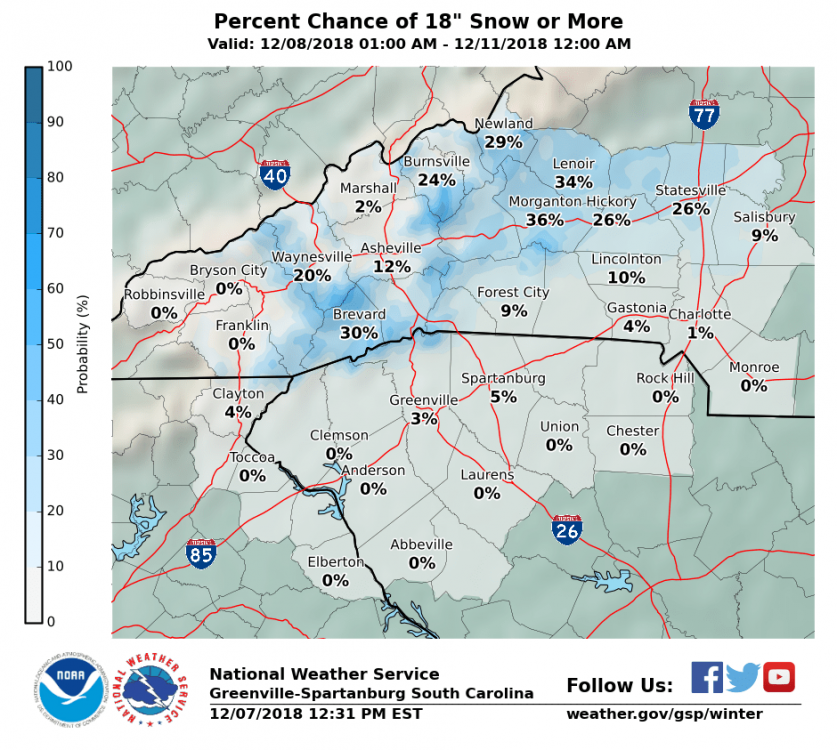
4. Do we need to cut down snow amounts? Maybe. But don’t forget we are using a 7:1 ratio anyway to start with (see my post from yesterday). So instead of 2.50” of liquid coming out to 17.5” of cement, maybe we go 2.00” of liquid and 14” of snow. I’m currently most comfortable going with a range of 8-12” for KAVL and the eastern escarpment. Boone will see slightly more sleet because they are actually *too high* in elevation and above the wedge into the warm nose. So instead of 17” there, I think 8-12” also applies to them.
Hang in there folks. Watch the 00Z trends. Can’t ignore the intense dynamics and the fire hose that is our deep tropical moisture connection!
Great information man, and I definitely appreciate it. I’m fairly new in Boone, and as much as I’d love to get 17” here, I’ll take the 8-12” and be happy. @AsheCounty48 warned about possible sleet earlier too. I’ve spent the last 20 years in Columbia, so it’s definitely an improvement!
-
1
-


2019/2020 Mountains and Foothills Fall/Winter Thread.
in Southeastern States
Posted
We ended up with almost 2.5” near Deep Gap. Best snow so far. This winter though, I’ll take what I can get.