

Boonelight
-
Posts
54 -
Joined
-
Last visited
Content Type
Profiles
Blogs
Forums
American Weather
Media Demo
Store
Gallery
Posts posted by Boonelight
-
-
Just now, AsheCounty48 said:
The one thing to notice is that's two nam runs in a row that get sleet into the mountains for a period that really hasn't shown up before.
Is that for the southern mountains or is it for the Boone area as well? Haven’t heard anyone mention sleet in Boone so far.
-
Just now, BretWheatley said:
Also, WSW up for Boone.
Yep, just saw that and was about to post. Looks like Blacksburg is on board.
-
58 minutes ago, HurricaneTracker said:
Hi all. I hear some folks have asked for my take on the current winter storm. Happy to help and participate here when I can and when I think my posts will be informative (rather than just banter or MBY endless posts). So here goes. AND do note - this is for the mountains of WNC only. Sorry other readers.
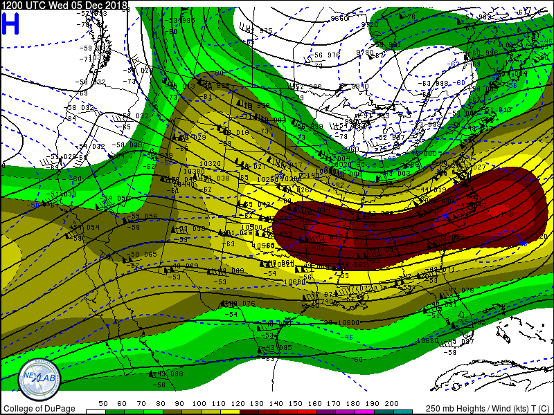
I think most, if not all, of you have the general idea that a big winter storm is on tap. That storm system is currently entering Southern California (which is a great thing for them!). They are in serious drought out that way and every storm system helps. The southern position of the upper level low moving onshore in associated with a strong subtropical jet are two very common characteristics of El Niño. So you will see some folks in the main thread refer to this as an El Niño wave. In El Niño years, the subtropical jet (STJ) flows fast from west to east from SoCal through southern Texas and into the Gulf Coast states. That is exactly what we have here. By Saturday, this jet buckles tremendously as our low gets carved out, with wind speeds greater than 180 knots (almost 200 mph)! This is very intense and only seen with the biggest storm systems in the mid-latitudes. The southeastern states will be under the right entrance region of the jet (a proxy for upward vertical motion).
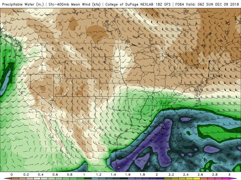
Then we have the full wave at 500mb moving in across the ArkLaTex region at 18Z Saturday. Meanwhile, a strong northern stream wave is forecast to be located over central North Dakota. Over time, the GFS model does not ever phase (I.e., merge) these two waves into one. Instead, the primary wave that comes into California scoots across the Deep South and induces a surface low pressure system near Houston, TX basically first thing Saturday morning. This low draws upon rich and deep gulf moisture (characterized by precipitable water values in excess of 1.40” - incredibly deep for December and sourced from the STJ and eastern Pacific! Wow! By Saturday night and into Sunday morning, this deep moisture is pointed straight at the southern Apps, much like a fire hose but with deep tropical connections. Meanwhile, as the surface cyclone moves into southern Georgia, we have southwest winds aloft but locally we have southeast winds circulating around our low. This in turn brings in a secondary layer of moisture at the surface, combined with deep tropical moisture aloft. I just cannot emphasize how big a deal this tropical fire hose is. Even in spring this would be a big deal (for severe weather/flooding reasons).
The surface low however has other things to work with. A seasonally-strong cold cP (continental-polar) airmass, will be building into the Midwest on Friday and Saturday. In winter, anything over 1040mb is a very cold airmass. This high pressure is basically squeezed east as the STJ buckles and mass evacuation (I.e., air parcels being ejected from the center of the low pressure in Texas), act to strengthen the squeeze (confluence) in the Midwest. Let’s not forget this high will be moving over some snow cover, which acts like a refrigerator. Some models handle the intensity of such highs differently. Regardless, all models take the high into New England and then the cold oozes southwest, hugging the entire Apps Chain all the way to western NC. Enter the wedge. This wedge is sourced from cold air in New England. Wedging is reinforced (I.e., positive feedback loop) by dynamical cooling from precipitation and ageostophic adjustment due to barrier winds. We have all those ingredients here. Southeast winds around the low act to also serve as an “upslope” mechanism, inducing upward vertical motion and enhancing any existing synoptic-scale vertical motions. Oof.
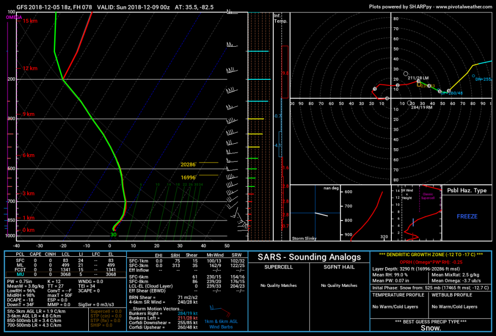
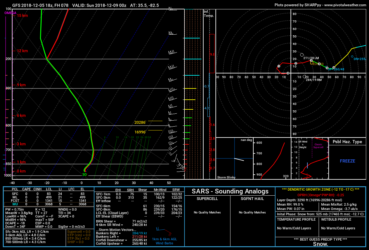
Score one for the NAM here. GFS has been very bad so far this year with wedging air masses (too warm). It has always played catch up while the CMC and RGEM greatly (and I do mean greatly!) overdoes the cold wedge. NAM seems to be the sweet spot (did I just type that?). It has a 1038mb high moving into position during the day Saturday. So, the question is, how cold? Ignoring surface temperatures for the time being, the 850mb temperatures (~5000’) stay below freezing the entire time! The cold is REINFORCED by precipitation and 35 knot southeasterly winds above the surface. Surface temperatures are also below freezing, as a stready wind vector from the NE funnels cool and dry cP air into the storm system, and the forecast soundings (thermal profiles) remain ALL SNOW on the GFS model.
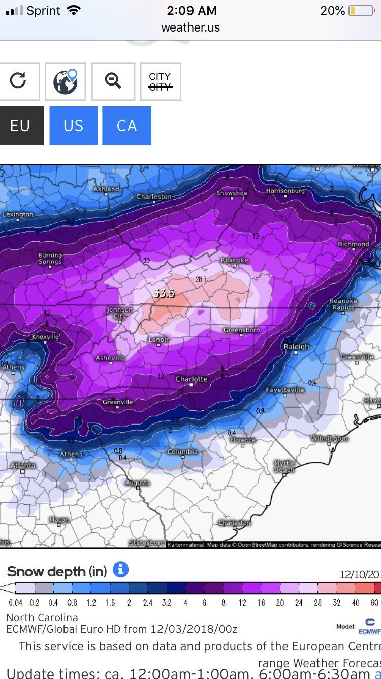
Take a moment and examine the thermal profile I shared here for 7pm Saturday night. Note that very deep isothermal layer (layer of equal temperature...below freezing) from the surface to 700mb. This is a classic WNC heavy duty, paper machete, snow sounding. And I can tell you our thermal profiles stay this way for a while. Oof.
So, let’s review. We have 1) cold high pressure wedging down...check. 2) source of upward vertical motion (double check). 3) moisture? Oh heck yea. CHECK. And this is just the southern stream wave! The northern stream eventually comes down to reinforce the growing trough over the east coast giving us our second punch in the gut.
OK.. now here is where I lay down my personal thoughts having digested and explained it all here. <takes off the gloves>
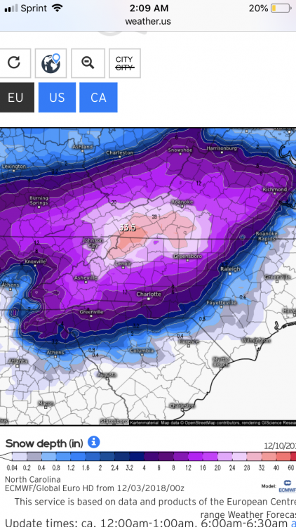
I want to impart a few things on you guys. Stop looking at the snow maps. They are assuming 10:1 ratios....and just by looking at those soundings, you can absolutely tell it won’t be 10:1 (I am thinking 7:1, based solely on experience). You should be looking at trends in the QPF. And you should NOT look at the QPF from the GFS - why? Because it has been wrong by a factor of 2, and even 3, most of the fall season in western North Carolina! (Not saying it could be right elsewhere, but for now, WNC has been missed badly by the GFS). Here the Euro and NAM models have performed very well in this department. And you gotta think...BIG source of tropical moisture. Plus Atlantic moisture. Plus vertical motion. Plus jet dynamics. When the dynamics are there the moisture will find a way. We are not lacking dynamics. Euro was around 3.00” of liquid equivalent. NAM isn’t out this far yet. GFS was 1.40” (multiply by a factor of 2 and you get 2.80”). Dang! That’s a LOT of liquid. Thermal profiles support snow, and maybe some sleet far southern escarpment as the warm nose tries to invade (briefly).
10:1 ratio gives you 28-30” of snow. Bwa ha ha ha. I can’t do it. Just can’t do it. What did GSP say, “generational” event? You bet.
7:1 ratio still gives 15-18” of cement snow. Oof. Who in their right mind feels good about issuing a forecast like that around here? It’s unheard of. Can it happen? It could. Would I go with these values at day 4 (looking at you WYFF)....no. Why not? Because the atmosphere is always in motion. Things flow like saltwater taffy being pulled from two ends.
And we still have time to watch this. BUT BUT BUT...we have been watching this since Saturday, Dec 1. It is equally mind-boggling to me to think that the large scale pattern and such has been so incredibly consistent for so long! The Weather Prediction Center now has the mountains 70-90% chance of a major winter storm at DAY 4! Wow.
The Euro has a 96% chance of 6” or more from this system. The GEFS mean is creeping up (on QPF...more snow, less sleet/ZR as the wedge is better reflected).
Oh and start time? BANK ON EARLIER rather than later. I have seen this time and time again. These systems break out precipitation along the warm fronts and into the cold dome earlier than most systems. GFS might have this right. Another trend to watch next 2-3 days.
Alright, enough rambling. Hope it’s helpful. TL;DR - get ready. Prepare now for a big snow event with potential for prolonged power outages. This is as big a deal since December 2009. if you live anywhere in the cold air damming favored areas of WNC (sorry Franklin), this storm has your number.
Incredible write up man. I appreciate the time you took to give us this information! You made this pretty easy to follow, especially for someone like me who doesn’t understand all of the technical aspects of forecasting.
-
 2
2
-
 1
1
-
-
32 minutes ago, SENC said:
Nice! While I had muh windeers open here at the Coast today, (airing out the house).. Like night & Day
Night and day for real! No way I had the windows open here. It’s been below freezing all day.
-
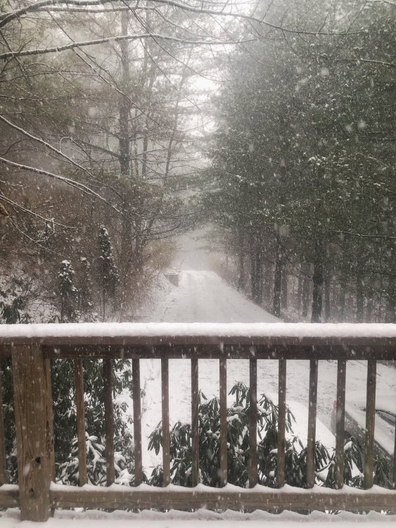
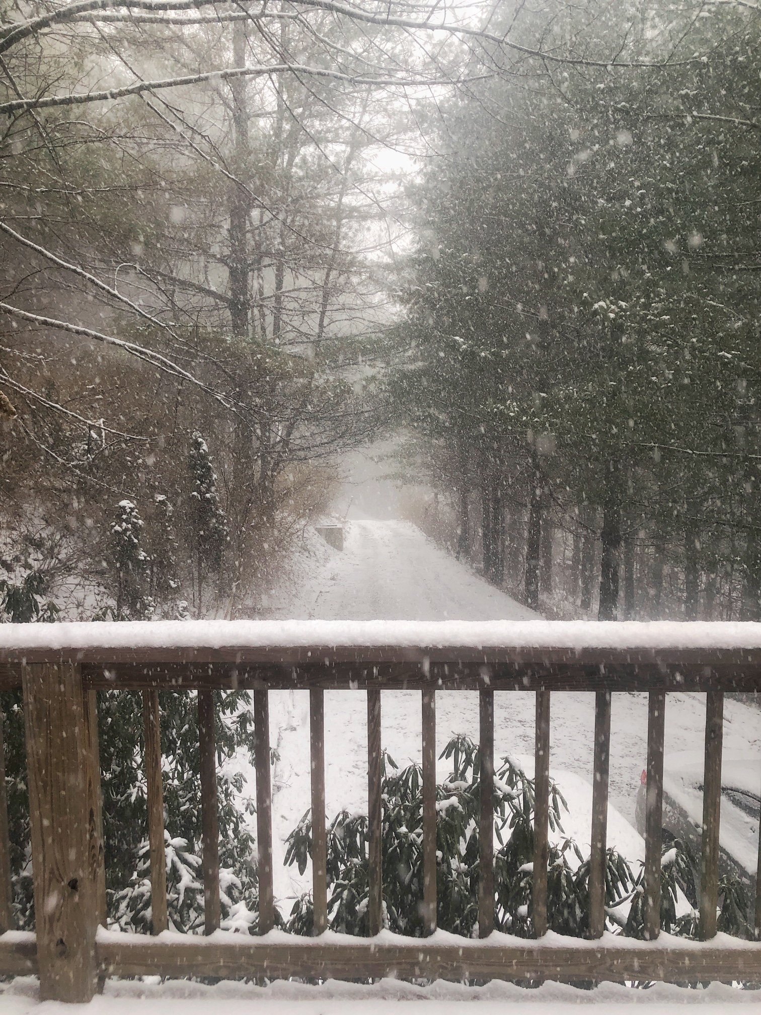
It is absolutely pouring snow again in Deep Gap. This pic doesn’t do it justice.
-
5
-
1
-
-
Coming down hard again. Close to 2” here. Love it!
-
1 minute ago, NCSNOW said:
Go to king street webcam boone if you want to see heavy snow. Holy cow to be up there right now
Can confirm. I’m not downtown, just east of there, and we’ve had several heavy bursts of snow. Didn’t expect this much to be honest.
-
1
-
-
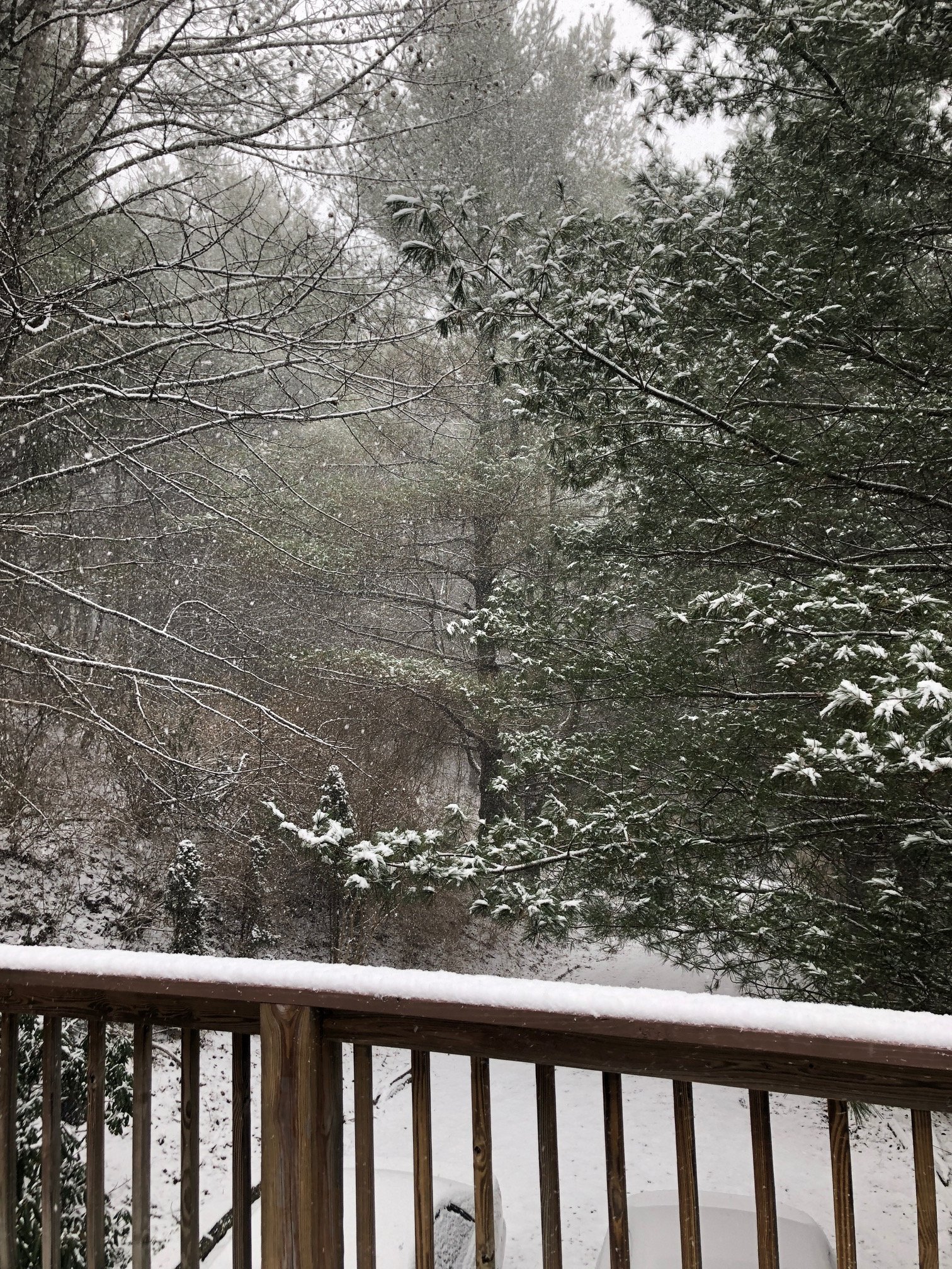
Went to bed last night with nothing, but we’ve got 1.5” of fluffy snow here in Deep Gap and it’s still snowing.

-
2
-
-
5 minutes ago, Met1985 said:
Yeah probably earlier than later. It really depends on how this all evolves. A lot can and will change with this system from now until this weekend.
Yep, I completely agree with that. We will just have to see how it evolves. Thanks again man.
-
1
-
-
2 minutes ago, Met1985 said:
It's way to early for specifics. If she is driving a Subaru then she should be fine but its everyone else that is the problem.
Thanks for the reply Met, I appreciate it. I agree about all the others being most of the problem, and I know it’s going to change from here until the event. They’ll probably need to leave earlier than later in the morning to avoid the worst of it though. I’ll definitely keep an eye on the developments.
-
No appreciable snow here, but I guess that could change overnight. I’m getting worried about this weekend, as my GF and daughter are leaving Sunday morning to go to Columbia. Anybody have any insight on how well maintained 421 to I77 is? And further south from there? She’s driving a Subaru, btw. I know we’re just starting to get a handle on this system and things could definitely change, but the trends point to a big snow here and a mess further down into the CLT area.
-
1 hour ago, ForsythWx said:
What
Oh man. That’s 28” to 32” at my house. Being this far out, it will most definitely change in the next few days. I’d realistically expect more like 6-10” or so, and wouldn’t be surprised if it were less than that.
I can’t believe I’m actually saying that! Having lived in the midlands of SC for 20 years makes you really jaded about snow chances.
-
It’s coming down pretty good here, and has been for the last hour or so. I hope this keeps up the whole night! We have at least 3/4” right now.
-
Ended up with a dusting overnight. Very light flurries are starting up again here near Deep Gap.
29°
-
This is what we ended up with this morning. Everything’s melting now, and the sun is trying to peek out. I hope everyone that lost power gets it back soon!

-
6
-
-
5 minutes ago, AsheCounty48 said:
Just walked outside. Roughly 10% snow, 90% sleet. Not really any freezing rain yet.
Just did the same. 10% rain, 90% sleet. Starting to build up on the deck. Much better than ZR.
-
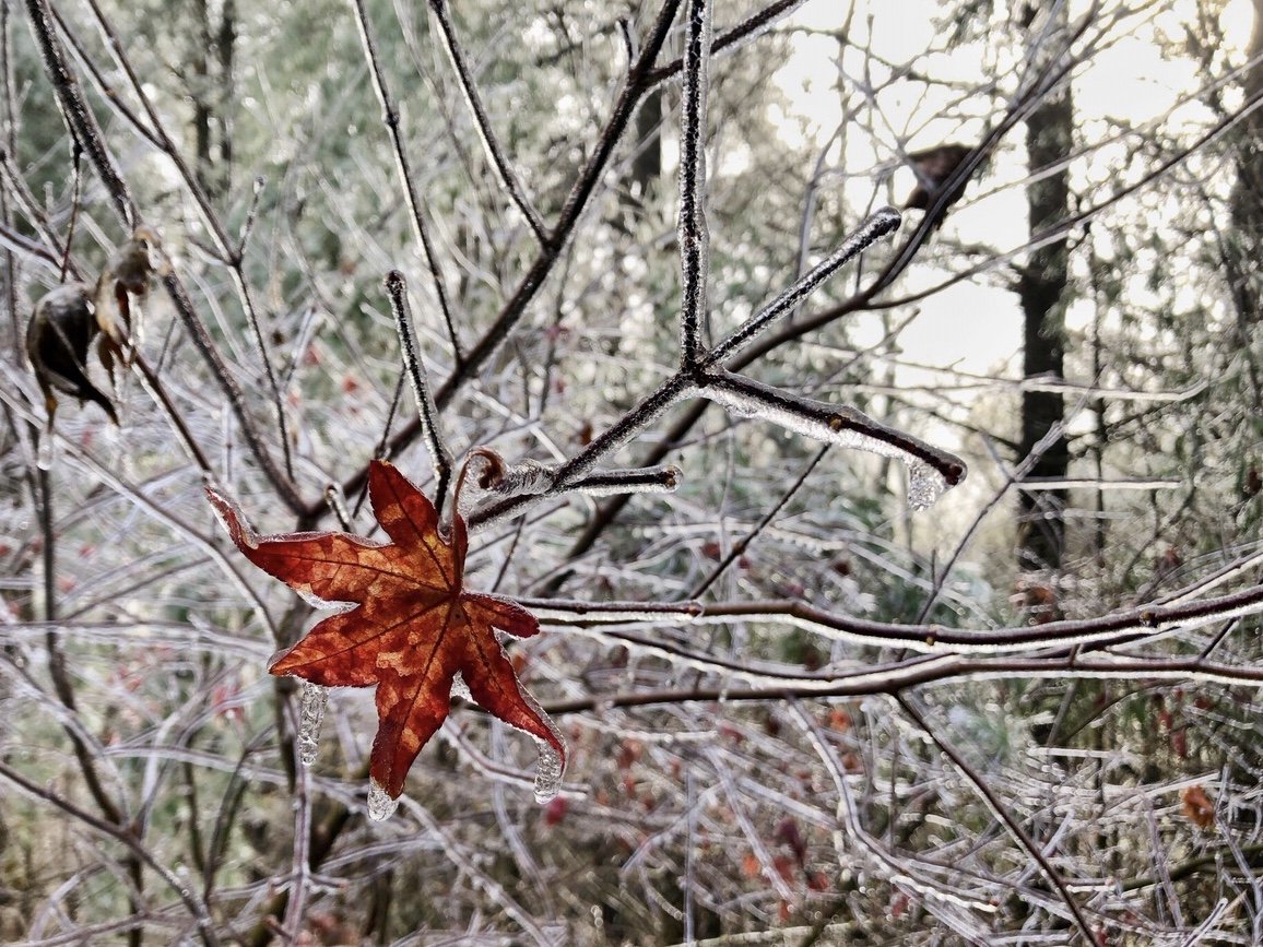
36 minutes ago, WeatherHawk said:
Frozen Fog today up here in Todd...very pretty...and very cold here ATM at 28...it's that snowy metallic-scent of crisp cold air that just hugs you when you walk outside, just feels like snow.
It’s been like that all day here. So nice to see. Such a pretty scene along 421 going into Boone. I don’t think my location got above freezing all day. Just freezing rain here now though. Snow would be nice!
-
Just came back from Food Lion on 421 outside of Boone. Starting to get freezing rain here. There was lots of freezing fog on 421 earlier, making quite the winter scene on the trees.
-
1
-
-
38 minutes ago, jburns said:
I'm hearing reports of a Christmas tree shortage this year. They say it is a result of the 2008 recession when fewer trees were planted by tree farmers. Trees planted around then are the ones being harvested this year. Some cut your own farms are reportedly not even opening this year. Have any of you mountain folk heard anything about this?
22 minutes ago, Tyler Penland said:There was an article in the watauga Democrat about it. I don't remember anything about the recession but we're down to 7 farms from 12 last year if I remember correctly.
Sent from my SM-G960U using Tapatalk
Yep, I saw the same article in the Democrat. I’m not sure how indicative this is of the larger tree farm situation, but there are 2 huge farms on our road, and one of them has been cutting them for the past week or so. There have been tractor trailer loads of trees going out, and plenty more to cut from what I can see, but I’d get one as soon as you can if you want a live tree.
-
Aaaand.... we’re back to ZR. Nice sleet show though. Fun times here at 3200’.
28° ZR on top of .5” of sleet
-
1
-
 1
1
-
-
Big time sleet near Deep Gap. It’s getting heavier as I stand out here. It’s actually accumulating on my deck and my yard.
29° Heavy sleet 8m E of Boone
-
1
-
-
It’s a solid sleet storm here on top of a glaze of ice here east of Boone. Hope it stays this way and we don’t get any more ZR.
29° 8m E of Boone
-
1
-
-
30° here east of Boone. Light glaze on my deck and on the trees. Rain is starting to pick up.
-
1
-
-
46 minutes ago, McDowell_Weather said:
This is our own thread say whatever you want bud.
39 minutes ago, Buckethead said:Welcome man! I moved to Asheville from the midlands the day of the flood and bought a house in Wolf Laurel last June. Just wait, winter is great up here! My name is Timm.
Heath, Timm, good to meet you. I’m David.
Timm, I lived in Forest Acres when the floods came. I’ve never witnessed such destruction. Forest Drive was a river.
I’m so looking forward to winter here.
32° here with light sleet and rain.
-
1
-
2018/2019 Mountains and Foothills Fall/Winter Thread
in Southeastern States
Posted
Ah ok. Thanks man.