

coolio
-
Posts
179 -
Joined
-
Last visited
Content Type
Profiles
Blogs
Forums
American Weather
Media Demo
Store
Gallery
Posts posted by coolio
-
-
Before someone cries: Drought! I see mainly non-precip days in the near future. I like it!
-
 1
1
-
-
Anyone foresee any problems with a flight out of National tonight at 8?
-
16 minutes ago, Eskimo Joe said:
TVS just NW of RIC on AKQ radar. Storm is currently unwarned.....
PM'd you on this. TL;DR: TBH, IMHO, IDK and RN.
-
With the low temps predicted, this won't "pop". Just generalized slow soakers. South may be where the action is.
-
My observations: It just looked like it was one rickety bridge. Went down easy.
Can't believe they got it on video.
I think I read that the captain of the boat knew that is was out of power and hard to control with plenty of minutes before impact. Why not drop the anchor?
-
I remember a few years ago we had this kind of warm-up in January. You run or bike under those road underpasses and it's cold for one brief moment. It's like the cold is hiding and planning its comeback.
-
2
-
-
22 minutes ago, H2O said:
A 2" rain this last weekend and a 1" rain today with 40mph winds will have some trees down. Again, I'm ok with schools doing what they feel is best to keep kids, staff and admin safe.
I hope it's 1". All the models I saw last night had this event approaching 2".
-
Rain/snow dome is full effect inside the beltway.
-
1
-
-
2 hours ago, Weather Will said:
Flood watch east of Frederick county MD....
Baltimore-Prince Georges-Anne Arundel-Charles-St. Marys-Calvert-
Northwest Montgomery-Central and Southeast Montgomery-Northwest
Howard-Central and Southeast Howard-Northwest Harford-Southeast
Harford-Fairfax-Arlington/Falls Church/Alexandria-Stafford-
Spotsylvania-King George-Eastern Loudoun-Northwest Prince William-
Central and Southeast Prince William/Manassas/Manassas Park-
Including the cities of Greenbelt, Germantown, Bethesda,
Sterling, Lexington Park, Annapolis, Laurel, Arlington,
Fredericksburg, Cockeysville, Eldersburg, Gaithersburg, Herndon,
Huntingtown, Manassas, Dale City, Leesburg, Severna Park,
Falmouth, North Beach, Franconia, Elkton, Ellicott City, Arnold,
Camp Springs, Falls Church, Dahlgren, Montclair, Reston,
Damascus, Ashburn, Washington, Alexandria, Lake Ridge, College
Park, Glen Burnie, St. Charles, Jarrettsville, Clinton,
Chantilly, Silver Spring, California, Odenton, Westminster,
Reisterstown, Dunkirk, Prince Frederick, Chesapeake Beach, Lusby,
Severn, South Gate, Rockville, Bowie, Aberdeen, Centreville,
Haymarket, Woodbridge, Annandale, Columbia, Lisbon, McLean,
Suitland-Silver Hill, Waldorf, and Baltimore
132 PM EST Sat Dec 16 2023

...FLOOD WATCH IN EFFECT FROM SUNDAY EVENING THROUGH LATE SUNDAY
NIGHT...

* WHAT...Flooding caused by excessive rainfall is possible.

* WHERE...Portions of DC, including the following , District of
  Columbia, Maryland, including the following areas, Anne Arundel,
  Calvert, Carroll, Cecil, Central and Southeast Howard, Central and
  Southeast Montgomery, Charles, Northern Baltimore, Northwest
  Harford, Northwest Howard, Northwest Montgomery, Prince Georges,
  Southeast Harford, Southern Baltimore and St. Marys, and Virginia,
  including the following areas, Arlington/Falls Church/Alexandria,
  Central and Southeast Prince William/Manassas/Manassas Park,
  Eastern Loudoun, Fairfax, King George, Northwest Prince William,
  Spotsylvania and Stafford.

* WHEN...From Sunday evening through early Monday morning

* IMPACTS...Excessive runoff may result in flooding of rivers,
  creeks, streams, and other low-lying and flood-prone locations.
  Flooding may occur in poor drainage and urban areas. Storm drains
  and ditches may become clogged with debris.

* ADDITIONAL DETAILS...
  - One to three inches of rain are mostly likely Sunday evening
    through early Monday morning. This amount of rain could cause
    flooding of small streams, creeks and urban areas. Localized
    amounts up to four inches are possible along and east of
    I-95.
Early Monday morning is 1am to 3am, ha!
-
7 minutes ago, Scraff said:
When’s that ball of rain arrive? That dry slot / lull rolling in from the East looks—well—dry?
 I’ll put the beer down now for a few mins—until the Os game starts.
I've been waiting for that ball of rain to get here since 11am!
-
1
-
-
Wishcasting is strong today.
-
3
-
 3
3
-
 1
1
-
-
Had to go to Burke on Sunday and I could tell they've gotten a lot of rain. Branches were so overgrown you couldn't see the road signs.
-
Pretty torrential for about 5-10 mins. Seems to be moving fast.
-
Someone done goofed at the SPC. There was not a Severe T'storm warning for this afternoon. Wha happened?
Picked up 1.43" in about 45 mins.
-
ABF: Another blown forecast.
-
OPM told all feds to depart by 3pm. I've never seen this for a line of storms. Is this a derecho?
-
Hoping everyone made it through ok.
I just got my power restored. Almost 24hrs w/o power. Got 1.03" in about 20 minutes. Rainfall @ 3"/min. Other than some branches down, Trees around here are ok.
-
Last night/morning green radar only netted me .12".
-
Radar shows that I'm enveloped in greens and yellows, but nary a drop inside the beltway.
-
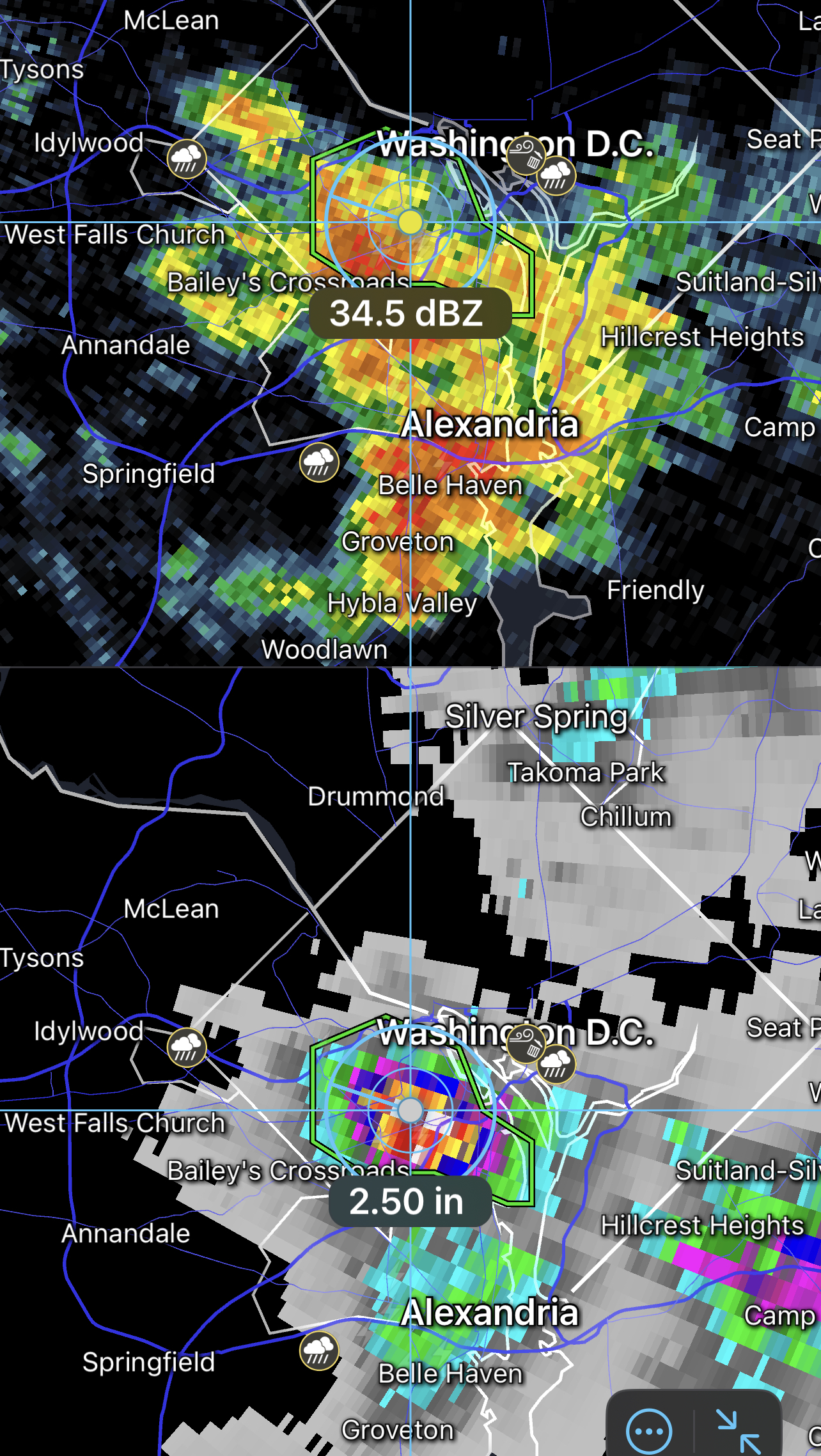
This one packed a strong, early punch. Picked up .93" in 15 minutes. Then it slowed down. Total=1.08"
-
Picked up a quick .22 in S. Arlington.
-
54 minutes ago, MN Transplant said:
Pretty cool watching the Arlington cell. The flow that would otherwise be pushing the cells to the east is balanced by the outflow to the west which keeps kicking up feeder cells.
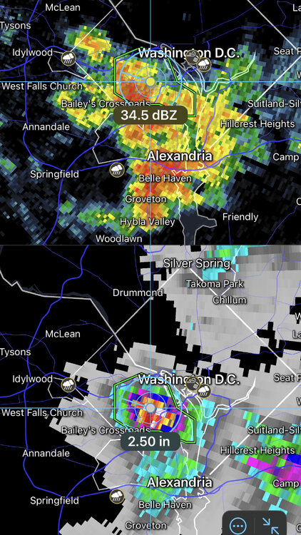
I was in that. Pretty strong. picked up 1.91" in an hour IMBY.
-
2
-
-
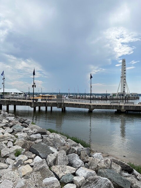
Looking out to VA from the National Harbor. This was about 3:30 today.
-
8
-
-
To the west of the FFX Falls church cell. Hear lots of thunder, but no big rain yet. just .06 and slowing down for the past 20 mins.
May Discobs 2024
in Mid Atlantic
Posted
My gauge read 1.06 this morning. Looking outside it may have been absorbed quickly. Doesn't look like 1". Either that or the squirrels have been taping on my station outside.