
brianc33710
-
Posts
262 -
Joined
-
Last visited
Content Type
Profiles
Blogs
Forums
American Weather
Media Demo
Store
Gallery
Posts posted by brianc33710
-
-
1 hour ago, Malacka11 said:
The headlights on the left side of the road in the distance is my car. Turns out it wasn't a wide tornado like I thought, it was actually a little shit at that point and I'm even dumber than I initially figured.
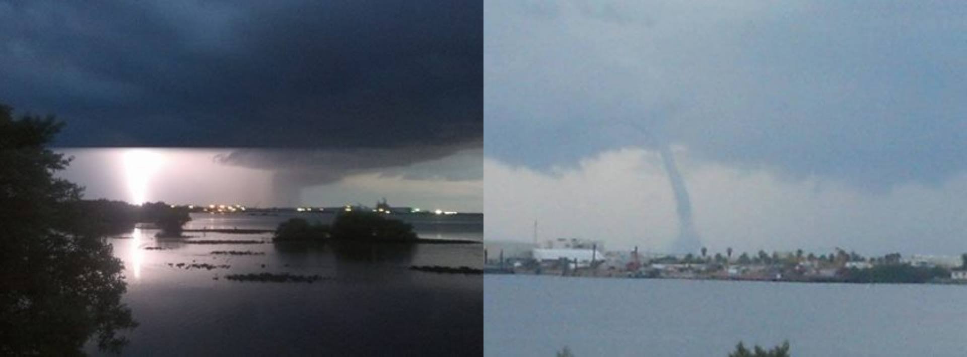
Well successfully tracking down a tornado that's just a little shit is better than no tornadoes at all lol. I remember 2013 when my apartment overlooked Tampa Bay I got a bunch of great waterspout pictures & videos. But my ex apparently deleted all of them from my Facebook without my permission (& a ton more). I only have 1 background picture that's 1/2 lightning strike & 1/2 waterspout left.
-
 2
2
-
-
AL was spared a fairly significant severe weather outbreak a few weeks back due to this warm capping. Most of the other ingredients were there for a notable event. Will this hold through the night? A strong storm headed toward San Antonio died before getting there.
-
So for Day 1 do we have 2 MODS, 1 big MOD, 1 HIGH & 1 MOD, or 2 HIGHS? I'll go with 2 MODS but will fully admit I thought the SPC HIGHS were an overreaction Friday. I wish I had been right.
-
1 hour ago, sbnwx85 said:
A rare Day 3 update from SPC:
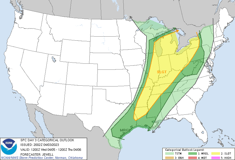
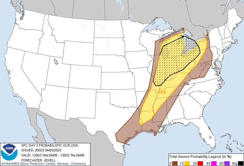
Day 3 Convective Outlook AMEND 1
   NWS Storm Prediction Center Norman OK
   0302 PM CDT Mon Apr 03 2023

   Valid 051200Z - 061200Z

   ...THERE IS A SLIGHT RISK OF SEVERE THUNDERSTORMS WEDNESDAY FROM THE
   GREAT LAKES REGION AND OHIO VALLEY SOUTHWESTWARD INTO THE LOWER
   MISSISSIPPI VALLEY...

   AMENDED FOR SLOWING UPPER TROUGH, WESTWARD EXPANSION OF SEVERE
   THREAT

   ...SUMMARY...
   Severe thunderstorms are possible over a large area from the Great
   Lakes region southwestward to the Lower Mississippi Valley
   Wednesday. This may include cells capable of producing tornadoes and
   extensive wind damage, primarily north of the Ohio River, with other
   severe storms expected into the lower Mississippi Valley.

   This amendment is primary due to the slowing upper trough, and the
   westward expansion of severe probabilities. Severe storms may be
   ongoing as far west as the St. Louis area at 12Z Wednesday, with
   favorable conditions remaining for tornadoes and damaging winds
   expending mainly northeastward. Farther south, lower 70s F dewpoints
   and heating ahead of a cold front is expected to support scattered
   storms during the day into the lower MS Valley, where mainly hail
   and damaging gusts will be possible. This westward demarcation of
   the severe threat will likely be adjusted further incoming updates.
The tiniest possible corner of NW AL is in the 2/5 now. Literally, if there's a house on the AL/MS/TN front yard is Slight & the house & back yard are Marginal lol.
-
1
-
-
2 minutes ago, Malacka11 said:
Concerns you as in "??" or as in "oh shoot, this might actually be a substantial threat after all"?
Concerns me that the potential for a more extensive & violent outbreak has returned. I apologize for not making that more clear.
-
1
-
-
21 minutes ago, bdgwx said:
12Z GFS isn't exactly what I'd call bullish with convection in SE IA, but it isn't devoid of it either.
The 12Z UKMET, OTOH, is actually pretty bullish with convection more so even than the 0Z cycle.
And the 12Z ECMWF continues to be bullish in this region.
I think given that I can't justify an argument against a moderate risk in the IA/IL border area.
The SPC didn't mention the possible inhibiting factors they mentioned in previous update. That concerns me.
-
3 hours ago, bdgwx said:
CIPS analogs are not as bullish for this event as they were the last couple of days. And based on model runs yesterday and the first ones trickling in this morning (9Z SREF and 12Z HRRR) there seems to be a de-escalation of the severe threat tomorrow IMHO. There are some significant dewpoint depressions (> 12 C) in the current risk area especially in the southern part of it with only isolated elevated 0-3 km CAPE values. With the presence of a strong cap and weak forcing I don't think it is unreasonable at this point to argue in favor of the position that the convection may be sparse and isolated. I realize the severe risk of any hypothetical supercell that does manage to mature could be high, but just how many of them will there be? I have to be honest. I'm even questioning the moderate risk at this point. I'm not saying the SPC is wrong. I'm just starting to think a bit. I want to see if the 12Z ECMWF holds firm with it's more bullish signal on convection.
I remember at least 2 2022 severe weather events in AL that were expected to be fairly extensive, 3(E)-4(W)/5 threats. The models showed a warm & humid influx of air from the Gulf. While the warm air mass arrived the humidity didn't. We had 80s/30C temps with >50 mph/80 kmph wind gusts but dewpoints held in the low 50s/10s in Bham & not much higher in Tuscaloosa which is almost always more humid than Bham. Usually the baseline dewpoints here for severe weather weather is 55F/12.5C. As a result we actually had a number of wildfires because of downed powerlines in advance of the delayed rain. But instead of a tornado outbreak we had less severe straight line winds. The dewpoints finally reached 60F/15.5C when the rain arrived but not before.
-
6 minutes ago, CheeselandSkies said:
The max I do see is 20...right on the Mississippi near Le Claire, IA.
IF you look at the "max" in the bottom right corner it's 25.47. Look closely cause it's not on the picture itself. I just messaged you too. Please read it when you get a chance.
")
-
1
-
-
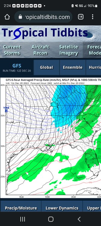
Check out some of these STPs. I thought the max was 20!
https://twitter.com/realStarInBox/status/1642715078809067521/photo/1
OK so this may or may not work.....
EDIT The link opens. I just couldn't share the photo itself.
EDIT 2: I had shared a hodograph using the above given STPs but didn't want to use someone else's work from another forum. So I deleted the follow up message.
-
2 hours ago, Jed33 said:
The GFS is also getting colder for Friday morning! Seeing a lot of sub zero I40 N
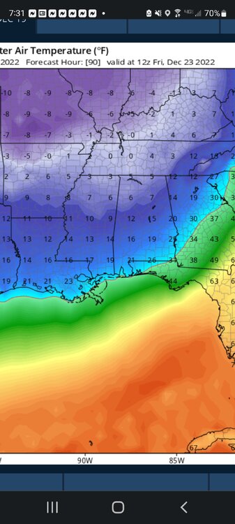
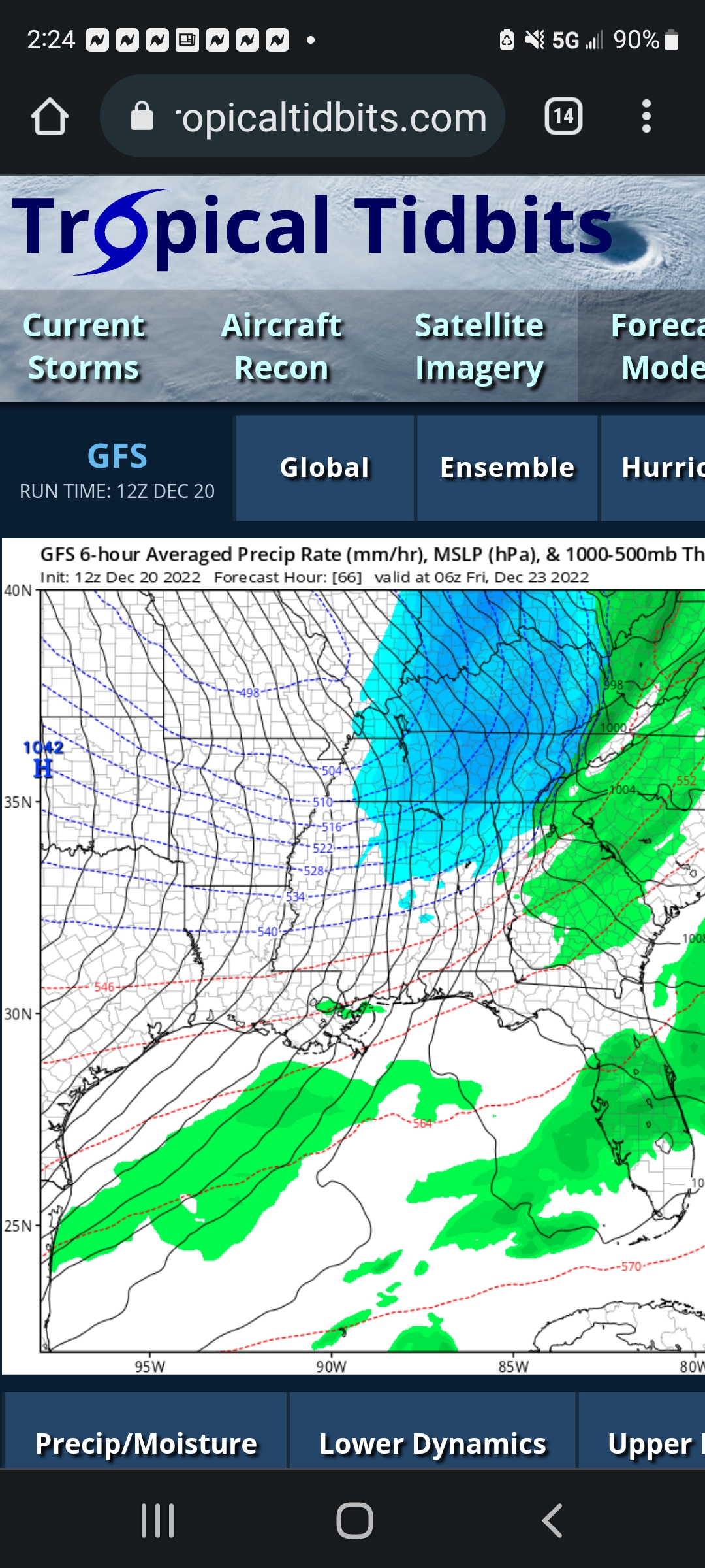
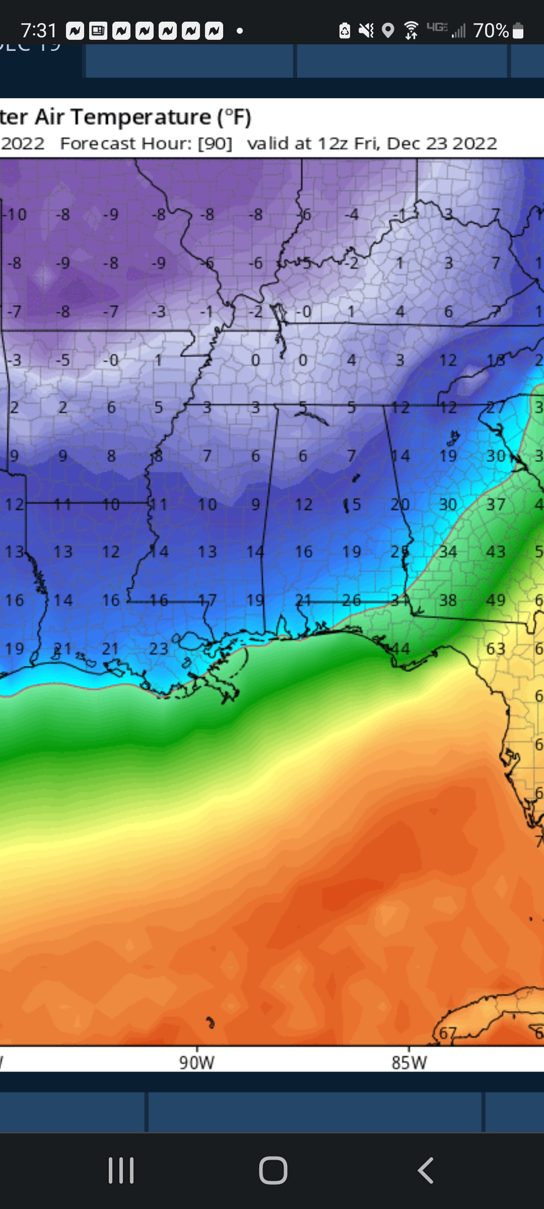
I saw Spann got caught off guard tonight when the model showed a 6F/-14.5C for Bham in this outbreak. This must be what you found. He felt the reading was too low. I'm still sticking with 7F/-14C as Bham lowest, which would match Jans '03 & '14.
-
3
-
-
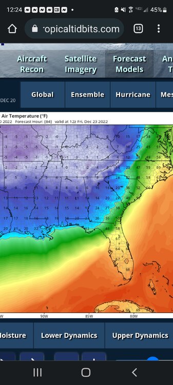
The GFS shows some snow for Friday. Given the severity & speed of the air mass I find it impossible to believe we wont at least briefly switch to sleet &/or snow. The GFS has Bham at 7F/-14C & Euro has 9F/-13C.
-
6 hours ago, Carvers Gap said:
The CMC has been verifying higher than the GFS and Euro at d10+. Several times it has had a correlation coefficient of 0,8 or more.
I know last night the CMC showed the area having sub 15F/-9.5C for nights on end. I started a feed in the SE forum. I couldn't find 1 so I started 1.
-
I don't know if anyone has already started this. But parts of the SE US is forecast to experience its most brutal Arctic blast in 5-9 years, depending on the model. While they differ on the coldest morning, both the GFS (Fri am) & Euro (Sat am) forecast Birmingham to drop to 5-8 F/-15 to -13.5 C in this extreme cold event. The local guys are predicting 10-11 F/-12 to -11.5 C, but the models keep showing Temps under this.
-
 1
1
-
-
21 minutes ago, Wmsptwx said:
We have a 15 pct MOD for tornadoes and there’s zero
convo in any subforum lol.
The Tornado threat is fairly high. But SPC maps also significant severe winds & large hail don't appear to be expected today
-
Yes the SPC upgraded to a 4/5 about 1030. But the Fultondale, AL EF3 (Jan'21) & Nashville EF3 (Mar '20) formed in just upgraded to Slight Risk & the EF4 just east of Nashville formed in a Marginal Risk & 2% Tornado threat. So 3/5+ risks aren't needed for strong & even violent tornadoes.
-
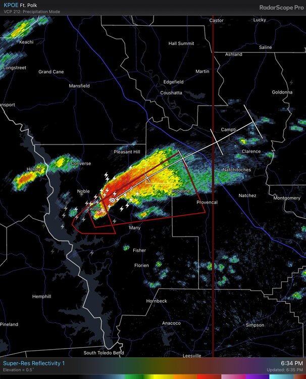
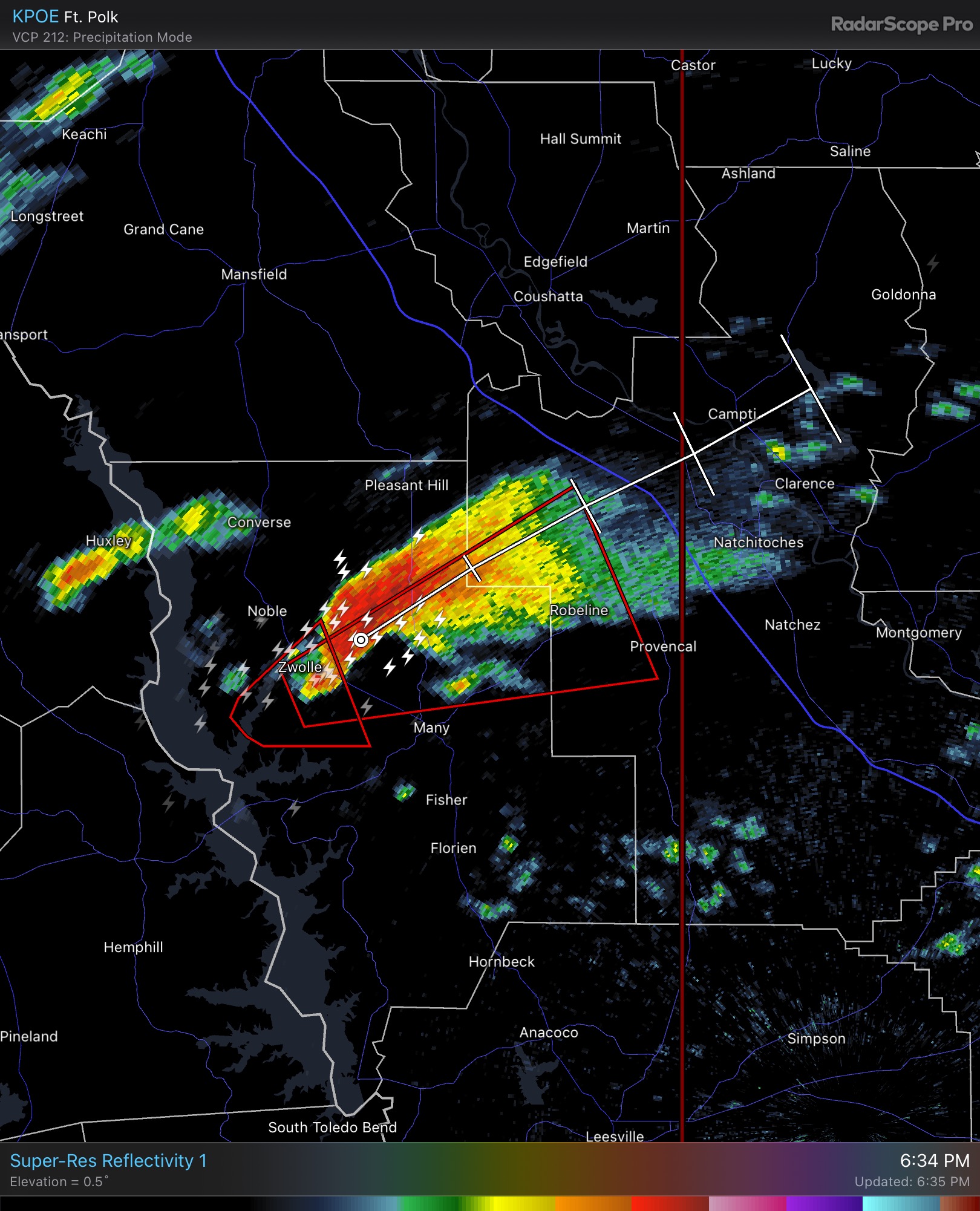
3 hours ago, nwohweather said:
Wow look at the form on this one west of Natchitoches. Great environment as well with ample instability
This thread looks dead too.
-
Is this thread dead?
-
I'm working but trying to monitor things from Hoover, AL.
-
1
-
-
TDS Shelby Co but no lightning strikes anywhere in Cen AL.
-
1 minute ago, yoda said:

Yeah that's bad!
-
We had a brief outbreak in central & west central AL & at least 1 appears was an EF2+ over Perry/Bibb/Shelby Co. But the situation down toward Mobile, which had 65+ dewpoints, still hasn't wound down.
-
21 minutes ago, Wmsptwx said:
Looking like it will, discrete looks unlikely at this point.
The temps definitely warmed up with the very strong southerly winds but the dewpoints never increased. Last time they at least got close to 60 but today in Bham the temp briefly got to 55 before falling back to 52. Even right now with rain nearby its only 54. But I did hear that the low moisture content could make straight line winds worse than otherwise.
-
27 minutes ago, nwohweather said:
I was thinking the same thing. Ours is obviously being buoyed by the ocean as that mirrors the ocean temp, but dews drop hard to below 50 once you reach even Charlotte.
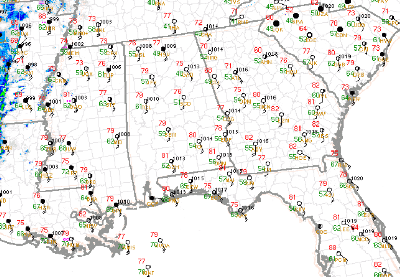
So Cen AL is in a "dry" dewpoints slot? They're higher east & west of here. I didn't know east GA & SC were 60+ too.
-
I'll remain bearish for areas near Birmingham. Last time stout SE gradient south winds brought warm air but the dewpoints barely cracked 60 in Tuscaloosa. SW flows bring in more moisture. Right now we're 74/51 & our flow is more SE than SW again. The warmth is there but not moisture & instability. Also as I've said before all of our threats since last March were at least somewhatdiminished by lingering convection that gave us very heavy rain. Eventually our "luck" will run out but I don't see that streak ending today/tonight. .

Severe Weather Threat 6/14
in Southeastern States
Posted
PDS Severe Tstm Watch in Cen MS. Storm Prediction Center PDS Severe Thunderstorm Watch 293 (noaa.gov)