

Chreeyiss
-
Posts
43 -
Joined
-
Last visited
Content Type
Profiles
Blogs
Forums
American Weather
Media Demo
Store
Gallery
Posts posted by Chreeyiss
-
-
12 minutes ago, TexMexWx said:
Definitely, if there are any outflow boundaries, they could set up localized areas of higher risk, but it won't matter if the cap doesn't break. I'm no expert though, and I really don't know what to think about the setup overall. The Weather Channel app is telling me there's about a 90% chance of storms tomorrow, as is also suggested by one future radar website I pulled up. However, the convection-allowing models I looked at on pivotal weather for the most part show little convective activity over here, with a couple exceptions, but nothing particularly concerning (in the DFW area). The ingredients do look to be in place though, so I am just not sure.
This strikes me as one of those events that’s so common around NTX where the models push the dry line too far east and then slowly pull it back west over the 24hours leading up to the event. I suspect the spc and nws have been holding the same opinion, given that the risk area since 2 days ago has been outlined further west than models often depicted. But that doesn’t say much about how severe these will be or not. Definitely have to acknowledge the conditionality of this setup.
-
I think a portion of whatever makes or breaks tomorrow’s event will come down to if and where outflow boundaries set up as a result of tonight’s convection in Oklahoma. That, and the obvious question of where or if the cap breaks.
-
Looks more like a broad circulation to me. Not very tight but velocities may be increasing
-
Couplet is looking weaker. It could be about to cycle and hand off to a circulation to the sw
-
How are you able to get the text and graphics for the new outlook? It’s not even showing up on the spc site yet for me
-
What about the Monroe tornado? I remember seeing someone post in here that the couplet was near 200kts at peak. With the lack of attention it seems to be getting I’m guessing the ground truth doesn’t match.
-
Well at least downtown Atlanta missed the bullet. What has been going on with the NWS in this area? A number of tds’s have been warned late or not at all tonight.
Also, new line of storms forming out west. I thought this was supposed to be the last of it. Any tornado potential with those as well?
-
Couplet intensifying sw of Atlanta
-
Something may be on the ground north of whitesburg. I can’t even make out a velocity couplet, but there’s a blue/green blob moving ene on cc. Atlanta may need to watch this.
-
Think we’ll need to keep an eye on the storms moving through Carrollton now, those look like they’ll be the ones headed for Atlanta.
-
1 minute ago, twistingtornado said:
There's no TDS. No couplet either.
There was briefly.
-
6 minutes ago, Thrasher Fan said:
Storm tightening up near Eclectic, AL
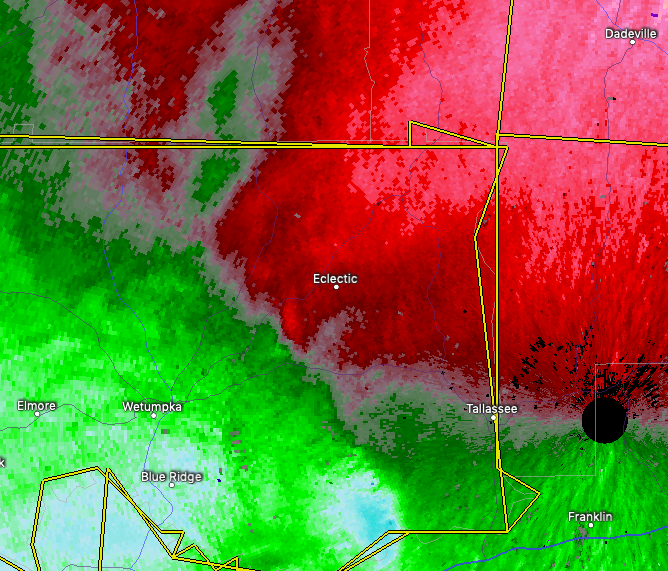
Good call, small tds now, though still not warned.
-
Weak tds may be starting to show up on the recycling Chattanooga cell
-
Just now, SouthernNJ said:
The former Chattanooga storm could put another down in Cleveland if
the bookend circulation condenses.
Agreed, it does look like it’s trying to recycle
-
25 minutes ago, jojo762 said:
18z NAM was incrementally faster than 12Z but verbatim it actually expanded the area of best parameters. The speed of the system, eastward movement of the dryline, in addition to the effects (and/or actual existence) of morning convection will all play a significant role in how Friday plays out. Euro/NAM both indicate a fairly active day across a large portion of the country.
STP obviously does not present the whole picture, but gotta admit I was fairly impressed by this. Likewise, the tornado threat is probably limited by mid/upper level flow that is oriented nearly parallel to the dryline... However, if the system ends up just incrementally slower, we could be talking about more favorable wind profiles.

Ive seen discussion on other sites, as well as a couple of AFDs that courser models tend to be a little overzealous in mixing the dryline eastward. I like the prospects of how that might give us a better setup than the models currently depict, but it does concern me that this episode might "sneak up" on the general public at the last minute, when the convective allowing models finally get within close range. And only a few hours' difference in timing could have pretty big implications on wind profiles as you mentioned, as well as CAPE.
-
53 minutes ago, jojo762 said:
12Z Euro setup shows what would probably result in a widespread severe outbreak from SE Nebraska southward into NE Texas with all modes of severe weather possible including some possibly significant instances of hail, damaging winds, and tornadoes. GFS is pretty gun shy, and the NAM looks much more like the euro, but the NAM shows the main tornado threat (and a possibly significant one at that, depending on storm mode) being relegated to SE OK/W AR.
18z NAM appears a little faster and not quite as deep with the trough as the 12z. According to the FWD AFD this afternoon, the 12z Euro has sped up a little bit too, relative to previous runs. Euro still shows pretty substantial storms back into N/NE Texas though. The level of severity on Friday is going to have a lot to do with just how fast that dryline mixes east, and how much the trough will dig and hang back out west. It would seem that the faster this system plows through, the less favorable the shear profiles are overall, and the less instability for storms to capitalize on.
-
 1
1
-
Severe Weather for 4/19-4/23
in Central/Western States
Posted
00z HRRR shows 5,000 uncapped at 21z but doesn’t show any convection in the area, despite really pulling back on coverage in the first round earlier in the day.