GansettBay
-
Posts
94 -
Joined
-
Last visited
Content Type
Profiles
Blogs
Forums
American Weather
Media Demo
Store
Gallery
Posts posted by GansettBay
-
-
12 minutes ago, ValpoVike said:
This was discussed in the noon AFD update:
In particular, there`s more aggressiveness about the late afternoon
and evening convection and resulting heavy rain/snow and cooling
temperatures. The convection allowing models typically overdo the
intensity/coverage of the higher QPF amounts and are likely doing
that this evening, but the idea of a round of vigorous showers and
a few storms along with the resulting couple degrees extra cooling
means there`s a higher threat of getting heavy snow starting a few
hours earlier this evening.
Interesting! Thanks for sharing. I'll take a look at the full discussion when I get a moment later on
-
Based on previously experience, I suspect that the changeover could happen sooner due to the strong upslope, which models often seem to struggle to account for. This could significantly increase forecasted totals on most of the models except maybe the HRRR, which shows similar QPF outputs to others, but higher snow totals. Any thoughts?
-
17 minutes ago, Ginx snewx said:
I believe it was said in jest. Takes Lucy to bring out the sand people
It felt personal lol. But you are right. I suppose we're all a bit disgruntled over this one
-
 1
1
-
-
13 minutes ago, Southshorewx said:
Did someone leave the front gate open? Who the hell are these people posting?
Things only a mason would say. This is a public forum mate, not another one of your elitist clubhouses lol
-
 1
1
-
 1
1
-
-
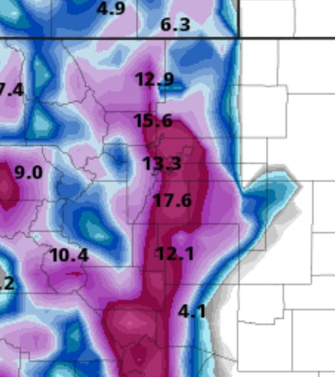
Just nuking in East Boulder. About 6" down and steady 1/2 mile vis. Looks like at least a few more hours of this
-
-
2 hours ago, Chinook said:
my thinking is that Ft. Collins/Loveland/Longmont averages over 50" and Boulder was like 76"
other notes: up to 61 degrees in Alberta Canada today (also 60's at Lewistown/Great Falls Montana today and yesterday)
SPC slight risk near San Antonio (probably not too much discussion needed unless somehow we get a tornado watch tomorrow) Obviously dew points of 50-60 in that area are unusual at this time of year.
Good info thanks! Models didn't seems to overstate the warmth this week and I'm operating under the assumption that this weekend will be no different. It seems like p-types around here will be highly dependent on how strong of an upslope we get.
-
2 hours ago, mayjawintastawm said:
You might be in a key position to illustrate the variability around Boulder and in Boulder County. As Chinook said, most measuring sites around Boulder tend to report jackpots- BUT they are likely west of US 36. I bet there is often a big gradient SW-NE across town. I wonder if Longmont has a reliable long-term measurement anywhere.
To answer your question, I suspect both answers are right. The BOU AFD this morning is a good read.
And honestly, big dumps are pretty uncommon. A 12" snowfall happens about every other year in areas below about 7000 feet. It's the 1-2-4" that add up to the average of 50-60 inches.
That is some good info, thanks! I did read that Longmont has a yearly average snowfall of 36" versus 96" in Boulder, which as you mentioned, is almost certainly measured west of 36. So I assume my location in East Boulder typically sees far less than that. I checked out the AFD as well. It seems there is a still a bit of uncertainty about p-types between 5-6k ft. It's quite an interesting setup that's for sure!
-
32 minutes ago, Chinook said:
I wonder how long you've been in Colorado? Like, I mean, normally Boulder gets plenty of enhanced snow rates, the Flatirons to the Front Range is set up nicely for that.
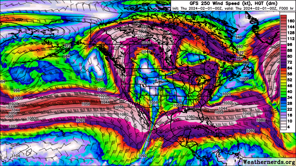
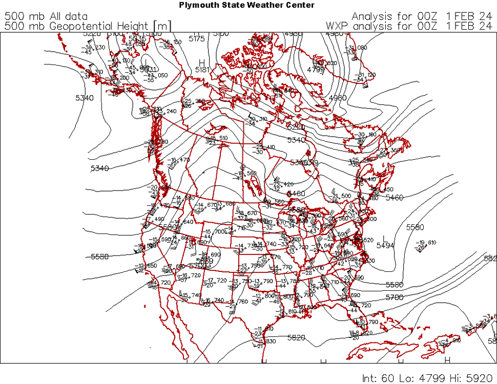
The very strange omega-block pattern, with storminess near you guys, will set up as this Pacific jet energy will completely undercut the huge ridge. Undercutting a ridge is something that does happens during El Nino. This is just a weird one.
This will be my second winter in Boulder. I have seen some of the heaviest snow rates in my life since moving here, but I think we only had one storm hit around a 9" total and nothing above 7" since then.
I know that temperature is going to be a big issue with this one as well. Is there any shot that the models are overestimating the warmth or is our best hope for this storm to happen at night?
-
4 hours ago, ValpoVike said:
Patience is key. We get our big dumps in March and April. I am up near Estes and one of the biggest I have seen was in mid-May.
Fingers crossed El Nino continues to bring us enough moisture for some good snows this season. I am in the very northeastern part of Boulder and frequently lose out to those sharp gradients between here and the foothills, but I can't complain after moving from coastal New England.
-
3 hours ago, mayjawintastawm said:
A guy named Steven over on Weather5280 looked at all precip events >0.4" water during Feb 1-20 at the Stapleton site over the last 75 years. Exactly zero of 16 were all rain, and the lowest snow/water ratio was 8. So two messages from that: this is indeed unusual, and we still are not at the time of year for big dumps yet, as ValpoVike says. I'm guessing that in RI, there were probably 100 events >0.4" water over that same time period 1948-2023 and probably half were all rain. (I lived in RI 1983-1987 so I get it too). But I'm not going to talk about the Blizzard of '78...

I saw that tweet as well. Those statistics have kept me holding on to hope, but expectations are lowered. I spent most of my life on the coast of RI and snow has become even rarer there. I think they've probably had a dozen rain events over .4" since December. As a snow fanatic it was pretty miserable sometimes
-
2 hours ago, Chinook said:
The models frequently have troubles with forecasting bigger storms at about 5-7 days. The problem is, you tend to think that they have a good forecast for wintertime scenarios if they have some consistency. Then like the last couple of days we saw, the consistency goes away as the models may shift important features such as precipitation.
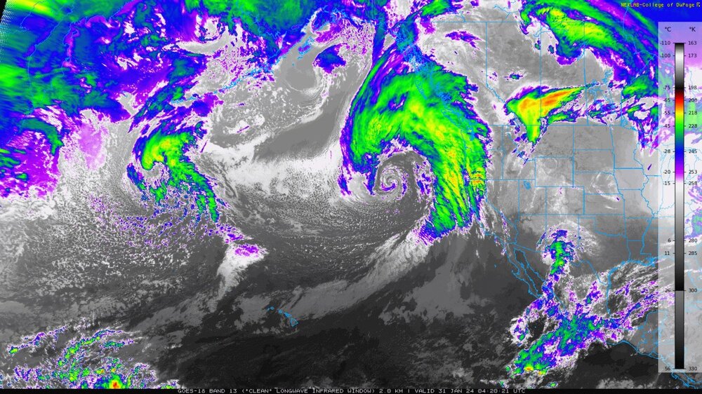
This is partly due to the fact that the models aren't perfect at any time. It's party due to the fact that the models ingest data from geostationary and other satellites. That's pretty much all you get from the Pacific, except for two upper air observations from Hawaii.
And as the other guys said, you guys are definitely due some winter to spring snowstorms from El Nino.
As you can see, there are no upper air observations from weather balloons off the coast. The models must gain weather information from GOES-WEST and low-orbit satellite types.
That makes a lot of sense regarding the difficulties in predicting storms out here versus ones that have crossed the entire US before hitting the East Coast.
I did hear Brian Bledsoe from the Desert Farmer Podcast mention that the el nino pattern is beginning to change. Hopefully we can still get some decent moisture out of it going into the spring.
Thanks for the educational content!
-
7 hours ago, mayjawintastawm said:
Welcome! Basically since there isn't as much measurement in the middle of the Pacific, it's harder to tell the fine details of upstream weather that feeds into the prediction models. But Chinook is a real met and could be more specific.
At least around here we don't have to worry as much about rain/snow lines with winter storms... except maybe for this one. Might be a Spring-like elevation storm. My biggest take-home message about winter storms since moving from central MA in 2010 is that QPF can magically go "poof" and vanish at the last minute. Dryness is a bigger enemy than marine warmth. Then, of course, you get things like the storm last May that dumped 6 inches of rain in 30 hours at my house.
Thanks for the warm welcome! And for breaking that down for me. I moved here from RI so I'm not stranger to rain in February, but I've been waiting for the big one since I've been out here and this seemed promising early on. Overall, it seems like models generally struggle a bit more in our region and it seems to be tough to nail down a confident forecast here outside of 48 hours. I don't do any forecasting myself, but that seems to be the case for a lot of the mets I follow on Twitter and whatnot.
-
 1
1
-
-
9 hours ago, Chinook said:
Would you kindly elaborate on these thoughts for a layman such as myself? I moved to the Front Range from the Northeast a couple of years ago and miss the highly detailed weather discussions in those forums. Nice to see that there's a few of you on here though!
-
Snow is picking up a bit here in Narragansett
-
 2
2
-
-
Just flipped to all snow here in Westerly. Giant flakes too. I didn't think the snow would make it this close to the coast
-
It's currently 66 here. Up almost 10 degrees since sunset. TWC says it's only 58 though. Am I the only one who finds that to be strange?
-
44 and snowing here
-
Walked outside wondering when the snow would get here and within 10 seconds it started dumping and a 50 mph gusts blew my neighbors trash cans into the street. That was wild to say the least. The ground was coated almost instantly.
-
 1
1
-
-
Looks like radar is filling in. Might be a few more hours of fun for the S coast
-
2 minutes ago, Damage In Tolland said:
Man... watch where that Norlun sets up tonight. Interesting
Where is it placed on current guidance?
-
Decent rates again. I might squeeze out another 1/2"+ in the next hour. Just over 4" on the lawn here in Westerly/ Pawcatuck
-
 1
1
-
-
My 1/4 mile marker just disappeared. Main roads are coated and the grass is almost covered. Pretty good stuff. I'm hoping that band over LI makes it up this way, but it looks like it might slip east too fast
-
Not too crazy here. About 1/2 mile vis at the moment. Probably 1/2"/ hr stuff. TWC has been pretty on point for most forecasts here this season. I expect about 3" by the time this wraps up. Maybe 4 if the heavier stuff stays overhead. I'm counting on the fluff factor to get me there


Mountain West Discussion- cool season '23-24
in Central/Western States
Posted
Same here. 8.5" in Gunbarrel with at least .5" compaction since the lull began. Hoping to break a foot with what's to come!