

Awesomesauce81
-
Posts
35 -
Joined
-
Last visited
Content Type
Profiles
Blogs
Forums
American Weather
Media Demo
Store
Gallery
Posts posted by Awesomesauce81
-
-
7 minutes ago, gtg947h said:
Yep, distinctly remember that one (though my son doesn't; he was 22mo). The next day we drove to Atlanta for wife's first brain surgery and observation... and it proceeded to snow again (up there) the night before we came home! I think we used up our quota for the decade...
Yep I'm patiently waiting for Jan/Feb 2028 lol
-
 2
2
-
-
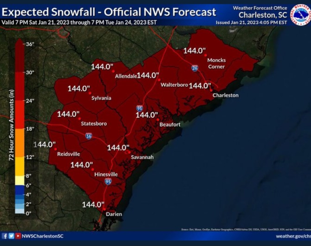
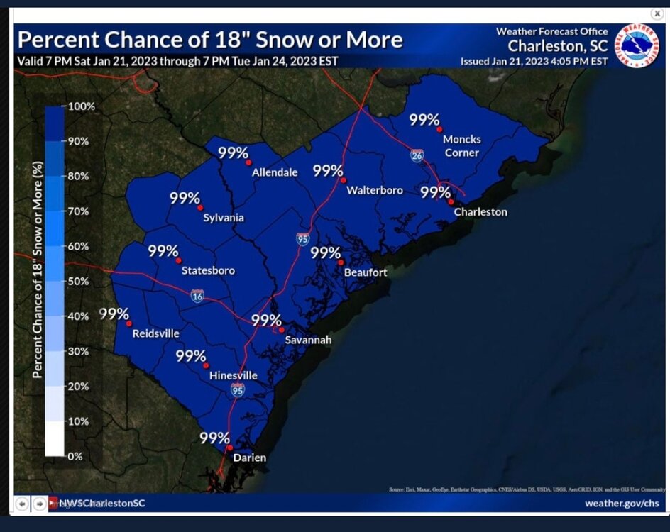 I don't know if this is the right thread for this but NWS Charleston accidentally tweeted this forecast out Saturday. I'm a snow lover but I'm glad this didn't verify lol
-
2
-
-
22 minutes ago, GaWx said:
For the record/entertainment since it is still way out in fantasyland (12/26), a large portion of that 2nd storm is sleet/ice during the majority of it within 75-100 miles of the GA-NC coast as 850 mb temperatures are or go above 0C. The 6Z GFS was colder at 850 with more snow but it had a lighter event. Regardless, the 12Z GFS is the 4th with significant wintry precip to the SE coast on 12/26 fwiw (still not much value other than entertainment that far out).
I don't think I've ever seen the GFS this consistent with a fantasy storm this far out, especially at the same timeframe. It's definitely caught my attention.
-
 1
1
-
-
3 hours ago, Upstate Tiger said:
My Wolfpack friends might want to pack the rain gear for Saturday night. Probably not a good tailgating game. Shame with Gameday in town and national TV for top 10 matchup. Looks really nasty.
Sounds like a perfect storm for a wild NC State win
-
 1
1
-
 1
1
-
-
8 hours ago, GaWx said:
Rainfall the last 2 days (all from thunderstorms): 7/8: 0.25"; 7/9: 1.25"
Together with the 4" 7/1 and 0.20" 7/7, I'm at 5.7" MTD through 7/9, which is nearly three times the normal for that period and not far from the normal for the entire month. Together with the 7" for June, I'm at 12.7" for the met. summer so far, which is close to the normal for all of June and July, combined. Considering that we've been in a severe drought thanks to well under half the normal rainfall and near the driest in the entire SE US from mid November through May resulting in soil that was almost as hard as concrete, this has been a great turnaround.
And now (7/10) we're just starting to get more rain with storms all around. I expect to update this later.
Edit for 4:25 PM 7/10 update: preliminary rainfall from today's storm is a whopping 2"+ with all of this falling just over the last hour causing the typical street flooding. It is still raining though it is slowly tapering.
Yet the official totals for KSAV does not reflect your reality ( I don't have official totals in myb but I'm sure I'm closer to your total). This leads me to believe that SAV needs more than one official station like Charleston.
-
1
-
-
5 hours ago, GaWx said:
In this area for this weekend, we have a legit shot at the coldest high and low since March 14th.
So, it is going to be a chilly Masters with it being the coldest at least since 2018. Also, later today through Saturday are looking to be windy. So, I’m expecting average scoring to be worse than most years.Was just telling a friend of mine that Masters weekend is usually our last cool weekend until October.
-
1
-
-
On 3/9/2022 at 5:44 PM, GaWx said:
@gtg947h
@Awesomesauce81
Like it or not, get ready for a freeze in our area Saturday night! The forecasted upper 20s would be the coldest since January 30th, within the top 5 coldest lows of the season, and the coldest in March since 2017.Bring it!!!!!! This heat and pollen had me congested for almost 3 days last week lol
-
1
-
-
8 minutes ago, Snownado said:
Dang. I didn't realize an inch of snow was so unusual for Raleigh. Are you sure you dont live in Savannah ?
I live in Savannah and just seeing flakes is a win lol
-
1
-
-
From NWS Charleston
LONG TERM /WEDNESDAY NIGHT THROUGH SATURDAY/...
An arctic high will drop out of the Northern Plains Wednesday
night, pushing a cold front into the area on Thursday. There
looks to be enough moisture and forcing for scattered showers to
accompany the front. The front is expected to stall just off the
coast and transition into a broad baroclinic zone. A potent
upper shortwave approaches on Friday, causing cyclogenesis
either in the eastern Gulf of Mexico or along the Southeast
coast.

There are significant model differences regarding the location
and track of the coastal low. The ECMWF and CMC have a much
wetter solution with the low developing over the eastern Gulf
and tracking up the coast. The 00Z GFS was considerably drier
than its 18Z counterpart and has the low developing well off the
Southeast U.S. coast, then tracking northeast. The QPF late
Thursday night through Friday night will be critical because
thermal profiles support some wintry precipitation.

Model soundings and partial thicknesses show the potential for
some freezing rain over northern and western zones late Thursday
night as surface wet bulbs steadily drop. On Friday, the
predominant p-type depends on which model you look at. The GFS,
with its offshore low track, indicates mainly snow would occur
across the majority of the area. Meanwhile, the wetter ECMWF/CMC
and its closer low track show mostly rain or freezing rain on
Friday, then some changeover to snow Friday night. All models
show drier air moving in from the west Friday night, ending any
precip by daybreak Saturday. Given that this potential event is
so far in the future (Day 6), we kept things simple by
introducing some freezing rain over northern areas late
Thursday night, then a combination of rain and/or snow Friday
and Friday night.
So they're saying it's a chance for the Lowcountry

-
1
-
-
2 hours ago, CaryWx said:
This is the one I want to see move NW
How about it stays right where it's at so I can enjoy my 2.7 inches lol
-
1
-
-
On 11/7/2021 at 5:24 PM, GaWx said:
Final storm recap:
My county had a storm total range of 3-5". My location ended up with ~4", which included short periods of moderate to heavy rains returning late last night on the backside after several hours of light or no rain. The last of the rain didn't end til 9 AM this morning. It started around noon on Friday. So, the elapsed time from the start of the storm's rain til the very end was ~45 hours! It wasn't a totally continuous 45 hours of rain but a good 40 or so of the 45 hours had rain. A storm with that much elapsed time of nearly continuous rain is pretty rare.
I was looking back at records and there was a similar November storm with heavy rains and chilly temperatures due to a similarly far SE tracking low November 15-16 of 2019.@gtg947h @Awesomesauce81(fellow SAV posters), any totals or thoughts regarding this storm?
I use to love those type of days growing up because they were so rare. As an adult who just had to work in that crap I was MISERABLE LOL. The analogs and long term forecasts may say otherwise but maybe a similar low can pop up with artic air in place and we can have some winter fun.
-
1
-
-
22 minutes ago, gtg947h said:
Yeah, it's getting really old. Had a break for a while before sunrise but now it's raining at the house again...
Yes it is. I stayed home and didn't go to work last night because I didn't wanna drive on the Port with the constant stream of rain. Hopefully it slacks off this evening.
-
1
-
-
4 hours ago, GaWx said:
Getting dark here to our west with lots of rumbling thunder and then I just saw that there is a severe thunderstorm warning for this area! Rain is just starting.
Yeah I was working at the Port when the storms came. With lightning being so close we had to stop working for about an hour.
-
1
-
-
4 minutes ago, ILMRoss said:
Lmao, I applaud the end of the 00z EURO for basically showing December 1989 part two at the end of the run, an event so near and dear to my heart that the date is my phone's lock code. I mean that with no hyperbole- it's basically its synoptic twin. Guys, i don't know if the threats in the next couple of days will pan out, but have solace knowing that this window probably isn't closing anytime soon.
I was grinning from ear to ear when I saw hours 228 to 240 lol
-
54 minutes ago, StantonParkHoya said:
I remember back in '09/'10, all the models kept showing SE snowstorms, feet and feet, then they trended into DC snowstorms. I want to see a south Alabama to Savannah snowstorm to feel good in Raleigh.
Personally I want that storm to not trend to Raleigh (I live in Savannah) but I understand your point lol
-
1
-
-
8 minutes ago, Buckfever2 said:
I don’t know about what’s going to happen for sure on or around January 3 but for right now it is 34 and a heavy sleet rain mix going on in Dallas Georgia and I do see a few flakes of snow. so the transition has begun in earnest. Might not be much or last long but, my seven and 10-year-old are having a ball just watching the sleet bounce around. I know that sounds weak but... hey we are in the south, the deep south that that. any little bit we can get Is much appreciate it... Especially for the kiddos !!
Look I'm down in Savannah I lose my mind when we get flurries lol
-
2
-
-
1 hour ago, yotaman said:
Anyone remember the Christmas of 1989? I lived in Va Beach and it got down to 11 Christmas morning. Where I live now got hammered by a foot of snow and temps down below zero. Coldest morning ever here. https://www.weather.gov/ilm/ChristmasSnow1989
Yep. Here in Savannah that was the best Christmas of my life
-
1
-
-
Can someone from Savannah send you guys well wishes? Rooting hard for you NE GA/Upstate/WNC folks.
-
5
-
2
-
-
7 minutes ago, SnowDawg said:
You can also include Eastern Georgia in on areas that really deserve to get something. Not up my way in the mountains, but the south of 85 Athens area eastward into SC. They got to sit and watch it snow over a foot in Atlanta suburbs in December 2017 while it rained all day there. I think they've seen a trace to an inch total since the Feb. 2014 storm
Damn!!! Even I (Savannah) have seen snow since then. I'm rooting for that area....and myself of course
-
2
-
-
11 minutes ago, mryanwilkes said:
E4 is drunk.
Well I'll gladly take what e4 is drinking....
Along with a shot of whatever member 18 from the 12z euro had lol

-
1
-
-
33 minutes ago, Tacoma said:
Need a Gulf Low to come across southern Ga. with that cold air in place.

With a high that strong a low MAY get as far north as Fort Lauderdale
-
8 minutes ago, griteater said:
My apologies for screwing some people over with the clown map snow on the old run...here's the SE version of 12z run...can compare them now anyway

Where is that area of snow in E Ala/W GA coming from and what needs to be done to get that blue over coastal Georgia
")
Mid to Long Range Discussion ~ 2024
in Southeastern States
Posted
You've done a wonderful job all winter Larry. It's almost like Mother Nature wants you to keep going lol