

PackWxMan
-
Posts
90 -
Joined
-
Last visited
Content Type
Profiles
Blogs
Forums
American Weather
Media Demo
Store
Gallery
Posts posted by PackWxMan
-
-
3 minutes ago, Poimen said:
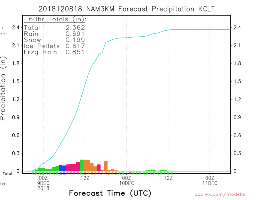
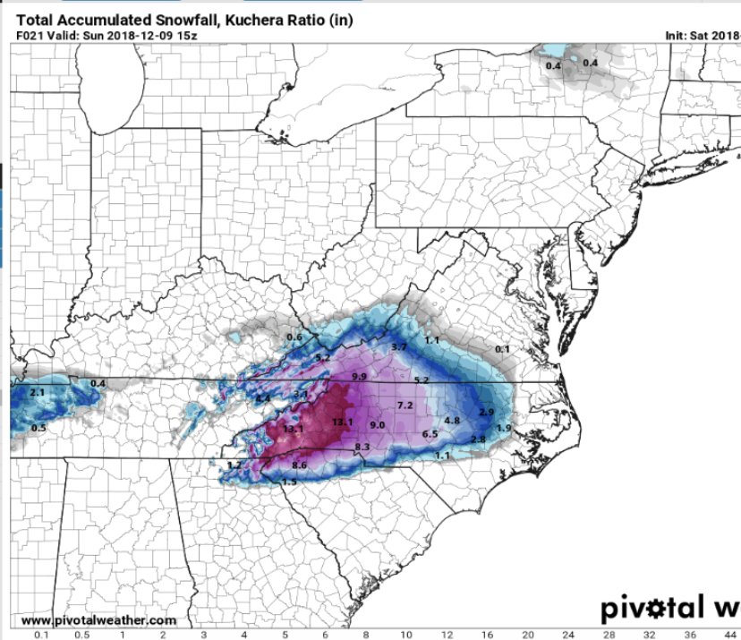
The 22Z RAP has 2" qpf amounts just south of the Triad and 17" snow totals in the Triad.

That would be significant. However, with the dry air, I see a lot of initial moisture eaten up. My guess is 1.25-1.5 for Guilford county
-
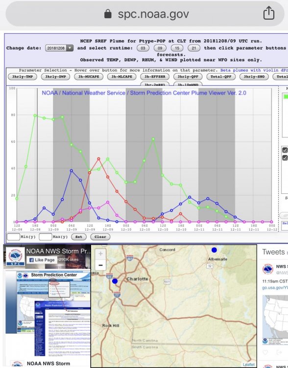
HRRR / RAP and Global’s have CLT and RDU in the game. NAM not so much.
After studying some upstream results HRRR performed best on my score list. However, Texas (Lubbock) doesn’t deal with CAD.
climatology and watching some upper level jets suggest the cad will be eroded in the 850 layer due to a strong jet.
My my prediction is Best case for the two metros would be 2-4. Greensboro cash’s out with 6-10. Foothills and mtns upwards of a foot and higher.
-
 2
2
-
-

Coming into scope now... Sleet and Rain (both normal and freezing) the primary elements in CLT. Strong SWly jet going to be too much and will help erode CAD aloft.
-
-
1 minute ago, Cornsnow said:
Still not completely over. We really do not know what the complete outcome will be. Sure if you are further south on the normal battleground it could be worse but there is no guarantee. We still need to see how it plays out. I would not be surprised either way at this point.
The HRRR is holding on - its historically good with eroding CAD on model verification scores. It's still looking good.
However, there is a 50+KT SWly jet aloft, that doesn't bode well.
-
12 minutes ago, ryan1234 said:
"If you haven't prepared for this winter storm, your window is closing rapidly. Driving will be dangerous AT LEAST tonight through tomorrow PM and many folks will lose power. A bunch of us at the office at GSP are even planning to sleep here tonight. This is one to take seriously."
This just came in from GSP's Facebook page. Despite some of the newer globals, I am not quite ready to call this a "bust" yet and go cliff diving. Yet, it seems like a lot of you have already jumped and are plummeting to the ground.
Nobody is “jumping off a cliff” - people are consuming the data. Right now it follows what most expected. A warm nose eroding cad.
-

As the HRRR enters the picture
-
-
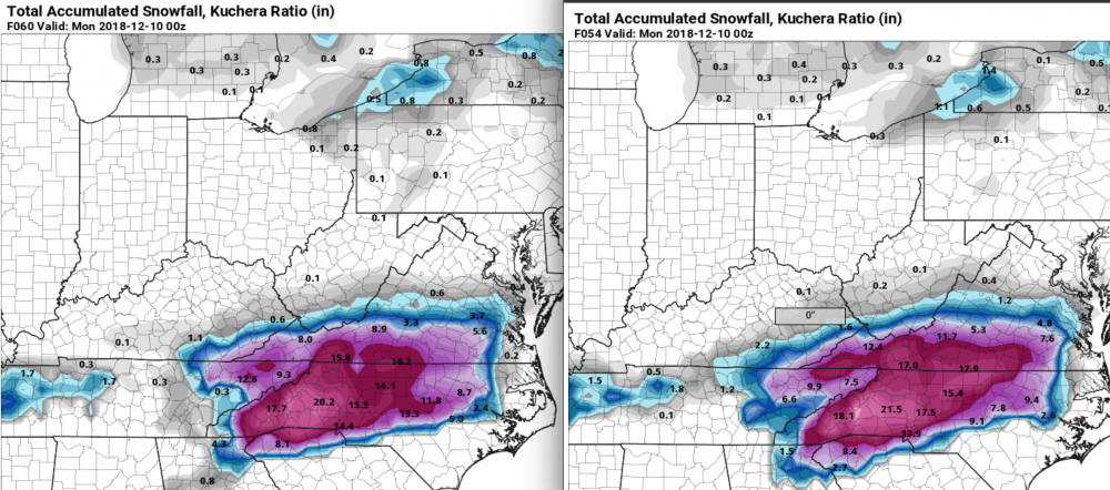
While the GFS likes central NC. The EURO had a strong shift north. Im guessing the EuroENS will follow the op run.
NAM did so well last winter, now that we see Euro adjusting towards NAM it worries me that it is simply getting a better track on the L and the warm air aloft that comes with it.
-
 1
1
-
-
7 minutes ago, Poimen said:
A question: I'm wondering if the last few cases of warm noses winning out occurred in conjunction with a similar well-placed CAD?
yes. The warm nose will almost always win out.
-
1
-
-
2 minutes ago, beanskip said:
It must be nice to speak so authoritatively on a subject so few have been able to fully grasp. I envy that. True clarity is much harder for me. By the way, you opened a parenthesis and didn’t close it.
Merry Christmas!
-
 1
1
-
 1
1
-
1
-
-
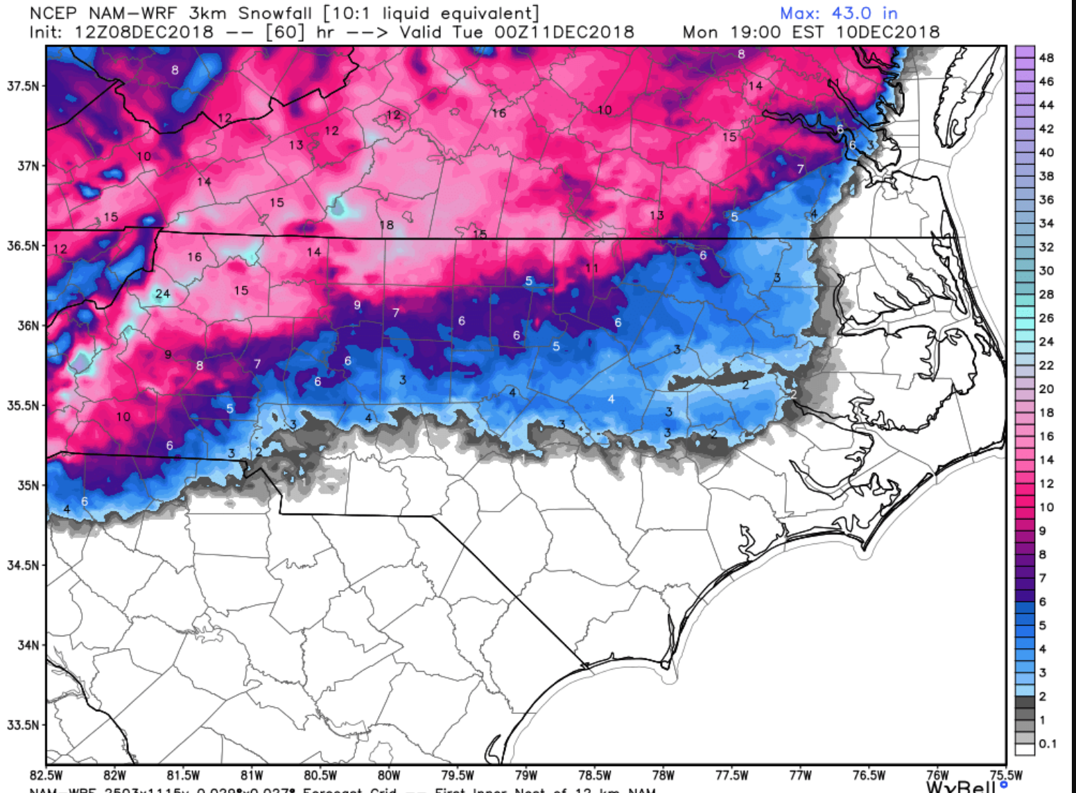
As mentioned yesterday this is a sleet storm for most (CLT/RDU even the Triad). While I do think the Triad can see maybe 8 inches (and thats a lot, this remains a snowstorm for Winston West and a mixed bag of let down (if you like snow) for the majority.
-
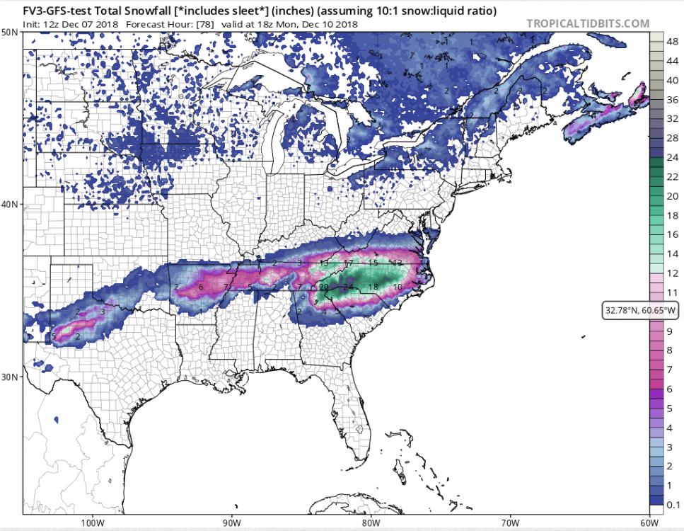
FV3 a
Actually the FV3 jogged north on this run. Which includes sleet.
-
32 minutes ago, FallsLake said:
This would be a fun storm for RDU. 6" of snow and 1" of ice.

This isn’t a 10:1 ratio event. That would equal 2-3 inches. Still nice though!!
-
1
-
-
Yeah. Western N.C. will see snow. However the majority of us in NC are in the metro areas. CLT / Raleigh and even greensboro.
I like the runs yesterday but today it’s been a nose dive into warmer temps aloft and fading precipitation at the hands of the CAD. All good. It’s early dec. plenty more months. Sleetfest 2018 incoming.
-
1
-
 1
1
-
3
-
-
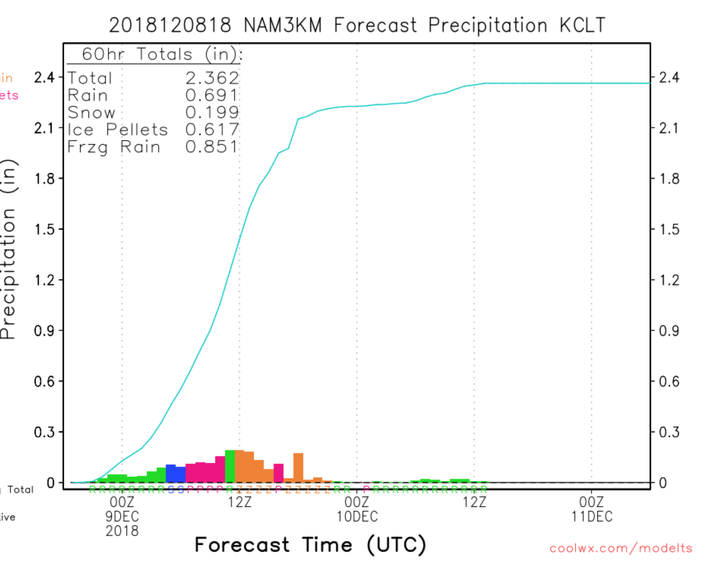
Reports to the west of warmer mid levels than modeling showed. Nam going north, GFS calming down. All we can hope for is the FV3 and Euro hold. That’s all sleet tho. This is a sleet of r cold rain for majority of us regardless of what models show.
-
2
-
-
New Euro for all the weenie clowns
.thumb.png.ad85e76019fafe1ce8476645c7dec51d.png)
-
2
-
-
I blended the FV3 / Euro Ens / NAM and Im telling you, RAH looks good and Fishel will be caught with pants down if that concoction verifies.....
-
8
-
-
Yeah, was it 2015 when the SREF plumes showed like 12-15 for Raleigh and we got like 2? lol . Plumes are garbage.
-
3
-
1
-
-
1 minute ago, Iceagewhereartthou said:
I simply can't believe the consitancy of the FV3 over the past week, it hasn't waivered one bit. What a coup if the overall depictions (not clown map) verified. Still wish that western upstate minimum would go away and fill in with the heavier stuff but i guess it is what it is.
FV3 doesnt show sleet.
-
The plumes are a big buzz kill - stay away
-
1 minute ago, jkcraig said:
Fish just tweeted:
If you’re a snow lover in Wake County, you need to realize that there are many ways this system turns out to be a flop, and only a few ways for it to be a big snowstorm. This is precisely why we have taken the ensemble based probabilistic approach we have taken all week.
Wow - thanks Fish. You just explained EVERY snow storm in Raleigh. Which ensembles is he referring to?
For those unfamiliar with Fish, he is typically the most conversative forecaster on earth
-
3
-
4
-
-
Y
 eah........ nah.
-
3
-
-
2 minutes ago, wake4est said:
Like I KNOW the non-Kuchera fv3 clown maps are unrealistic but they are just astonishing. Like old-school DGEX snow outputs. They make my eyes happy.
lets see it


.png.10265a3d78ea80542ceda08836634014.png)

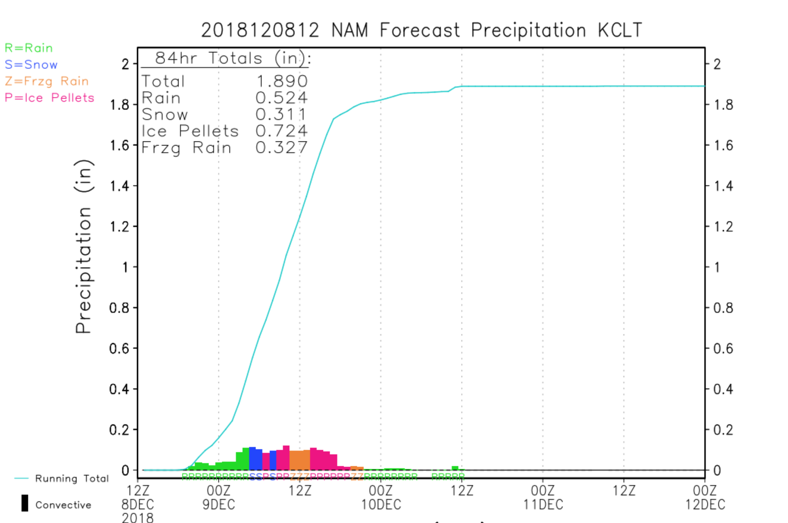
December 8-10, 2018 Winter Storm
in Southeastern States
Posted
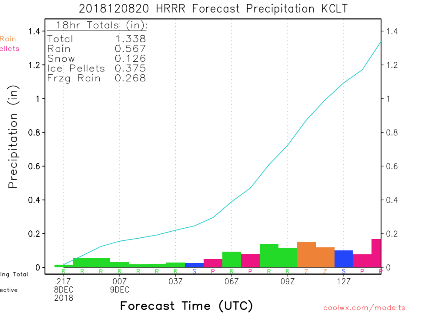
“Seeing pretty considerable sleet in my part of Charlotte, unfortunately expecting a lot more where that came from overall w/ this storm tonight & into tomorrow right up thru RDU even though taking the HRRR, RAP, & other models at face value says otherwise (bad idea).” - Eric Webb
Sleetfest for the metro area is imminent.