

Beachin
-
Posts
337 -
Joined
-
Last visited
Content Type
Profiles
Blogs
Forums
American Weather
Media Demo
Store
Gallery
Posts posted by Beachin
-
-
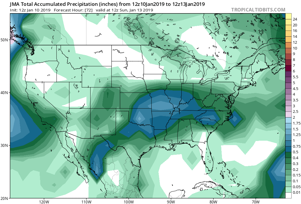
JMA doesn't run long enough to see the full extent but looks good

-
Personally us northerners i think will get into some decent ratios and some at least decent banding as the first wave moves in. Pretty decent vort is gonna pass and there is plenty of lift. Coastal would be a bonus but i think we have to bank on a decent lead wave. Temps at the surface and aloft are plenty cold.
-
 1
1
-
-
Nam isnt going to run long enough not that it matters but after 84 snow would overspread the area. Vort held back this run as you can see.
.thumb.png.c8bbe6c9c7edba61325156ce58228e47.png)
-
Gefs 6z

-
1
-
-
Uh yeah id say thats a jump north on the CMC

-
OMG the cmc lol
-
At 90 the faster progression of the coastal has the precip the furthest north its been in 4 runs
Low position is also the furthest north being over ENC96 its definitely trending north now 4 runs in a row precip goes further north.
-
Woah 84 this should definitely be better much better vort
-
66 more amplified then 18z vort still looks more organized and sharper
-
At 54 GFS is north and the vort looks more organized.
-
Icon looks identical to its 12z run.
-
 1
1
-
-
Nam most certainly looks better at 500 far better
-
1
-
-
anyone have the 18z euro?
-
2 minutes ago, Bob Chill said:
Good call. This panel is money and explains why the gefs had so many juicy solutions

Looks pretty money to me
-
There should be way more precip on the NW side then what the GFS is showing good forcing and the upper and mid levels are completely saturated. All and all I'll take it big big time improvements at 500.
-
Lol big hit incoming
GFS finally has snow to Chicago
500s really buckling
3 runs of a deeper sharper trough trend has formed this will only get better as it corrects north
-
 1
1
-
-
Much stronger and consolidated vort and much more amplification. Gonna be a vastly different run then 12z for sure coming north.
-
1
-
-
I suspect the GFS should come north some 18z
Icon looks like the NAM to a degree.
Buckle up
-
Icon is a big hit

-
3
-
-
3 minutes ago, paulythegun said:
Icon fringes the northern folks

This is 12z 18z is way different
-
Bowling ball incoming

-
2
-
-
I sense us about to be NAM'ED based off hour 57
-
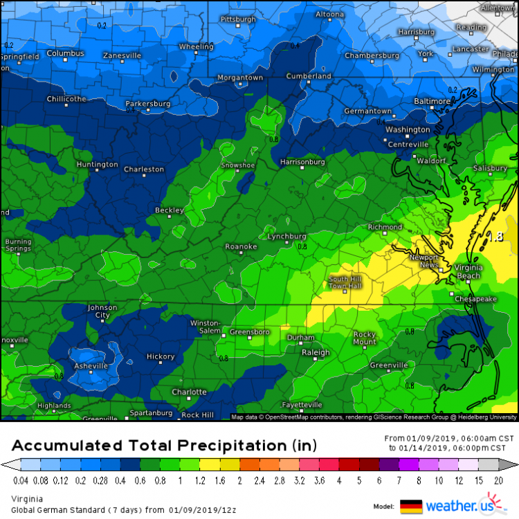
12z JMA

-
2
-
-
Its snowing pretty good here right now (bel air)
.png.903ff4885ac8bf371f48df0b51b6ad1f.png)


January 12-14, 2019 Storm Discussion STORM MODE
in Mid Atlantic
Posted
CMC projection of ratios matches pretty good with the GFS-NAM thus far. Looks like 12:1+ north of 70 with 10:1 south of 70 and lower as you go