

Beachin
-
Posts
337 -
Joined
-
Last visited
Content Type
Profiles
Blogs
Forums
American Weather
Media Demo
Store
Gallery
Posts posted by Beachin
-
-
Just now, Eskimo Joe said:
^take out those 3 or 4 high outliers and rerun the SREF.
Oh I agree for sure but 09z run had the mean at bwi 2 inches and now its 6 so it's definitely went up alot from this morning
-
I know it's the SREF but they have shifted north again from 15z. Here is BWI and even APG the mean Is 4.5 almost 5 inches

-
-
3k NAM keeping the trend alive

-
 3
3
-
-
Good to see the NAM finally show what it should have 12z
-
1
-
-
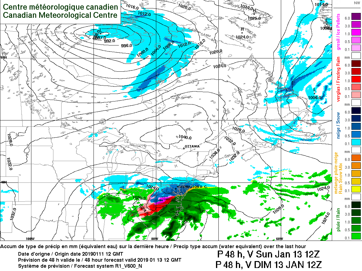
CMC Is better then its 00z run for most.
-
Kuchera ratios based off a blend of models
DC south side 11:1
DC north side 12:1
Baltimore South side 12:1
Baltimore North side 13:1 going up as you go north
Near the Masondixion 15:1-
3
-
 1
1
-
-
Just now, psuhoffman said:
We won't need a ton of qpf if we get higher ratios...so if we can get a small bump to like .3 we could get 3-5" up here...but if the coastal continues to trend stronger but not strong enough to influence us that could kill our area if it robs the lift and moisture transport from the WAA wave to the north sooner and everything collapses south as the ccb develops. If that ccb then does us no good we end up with weak sauce up here.
On the other hand... we are not within another 30-40 mile bump north from having a very good result even up here so its not impossible. We have seen it many times...we had about that much of a north adjustment at the end on the Dec 9 storm only it did us no good since we were 100 miles out of the game that time.
I just checked kuchera ratios and they are around 14:1-15:1 For northern MD North of the 695-70 area so i agree it wont take much QPF to have a good snow up here. If the coastal continues its trend north then we can get even better.
-
1
-
-
-
Trend is your friend

-
1 minute ago, jayyy said:
Except for the strong confluence in New England and a mainly west to east 500 mb setup
The confluence has been weaker and weaker ever run. The trend is to also not "flatten out" as much.
-
1
-
-
Nam is still struggling at the surface as to where the slp should be. This run could have been much much bigger for all. I suspect the "better" models will do better with it. There really is nothing preventing this storm from coming north.
-
At 42 the heights are way higher then 6z coastal should be north again.
48 so close to something big so so close
-
 1
1
-
-
Looks like the 6z runs other then the GFS are adding the coastal into the mix big time. Models are figuring this out at the last second
-
Jma looks good
.thumb.png.2b0d0aa6429b353f2555a1698fc90711.png)
-
4 minutes ago, AfewUniversesBelowNormal said:
GFS is doing the same thing the NAM did.
?

-
GFS looks good so far at 24. Seems to be working to close off like a few days ago. heights are higher and its more consolidated
-
Icon definitely has a much better vort this time
-
It's actually rather crazy how much better the rgem is vs the nam. Rgem is actually looking even better then 18z did lol

-
00z rgem maxed out at 48

-
1
-
-
Just now, BaltimoreWxGuy said:
I think your over exaggerating a bit. It’s a little better for DC and southern MD. More in line with Euro

-
GFS looks much better wow North push is real

-
1
-
1
-
-
You start to see a trend on the NAM

-
2
-
-
Just now, BristowWx said:
Looks like 12-1 all the way to I 66 to me.
Yeah i just used 70 as a good blend between Nam-Gfs-Cmc still not bad ratios


.png.4ab5f9cb85145639f86607929ce9f878.png)


January 12-14, 2019 Storm Discussion STORM MODE
in Mid Atlantic
Posted
Nam is definitely holding energy back resulting in a slower storm and slower transfer. Heights definitely amplified rather well to the closed low formation in the Midwest.