
Snowy Hibbo
-
Posts
30 -
Joined
-
Last visited
Content Type
Profiles
Blogs
Forums
American Weather
Media Demo
Store
Gallery
Posts posted by Snowy Hibbo
-
-
The not so bad climatic driver conditions for ENSO and QBO and the potential for a SSW show me potential for a pretty nice winter for New England in my latest winter outlook
")
https://longrangesnowcenter.net/2020/12/06/north-america-winter-outlook-2020-21/
-
https://longrangesnowcenter.net/2020/10/20/october-preliminary-2020-21-winter-outlook/
An interesting splash of factors, for the Eastern US, a few shifts (particularly on ENSO) from last time I dropped in:
- A basinwide moderate (possibly strong) La Nina this winter.
- A positive QBO
- Solar Minimum
- Atlantic SSTs favourable for a +NAO
- North Pacific SSTs favourable for a Aleutian Ridge.
- Average growth of Stratospheric Polar Vortex into winter, potential for SSWs later.
- Phase 3-6 MJO centred tropical base state
- Low sea ice in Barents-Kara Sea.
- Average snow coverage in Siberia.
Looking pretty average in terms of snowfall for the Mid Atlantic IMO.
-
 1
1
-
https://longrangesnowcenter.net/2020/10/20/october-preliminary-2020-21-winter-outlook/
An interesting splash of factors, for the Eastern US, a few shifts (particularly on ENSO) from last time I dropped in:
- A basinwide moderate (possibly strong) La Nina this winter.
- A positive QBO
- Solar Minimum
- Atlantic SSTs favourable for a +NAO
- North Pacific SSTs favourable for a Aleutian Ridge.
- Average growth of Stratospheric Polar Vortex into winter, potential for SSWs later.
- Phase 3-6 MJO centred tropical base state
- Low sea ice in Barents-Kara Sea.
- Average snow coverage in Siberia.
Looking at a slightly above average snowfall season for New England IMO.
-
3
-
Putting together an analog for a moderate-strong Nina winters since the 1980s, based in the Eastern Pacific extending into the entire basin:
- Troughing/low pressure in the Eastern Indian Ocean and over Maritime Continent, certainly goes with the idea of a strong tropical standing wave over Maritime Continent.
- Strong Aleutian Ridge, supports snowfall and cold in Northern America and Canada. Less North Pacific Jet extensions, less atmospheric rivers.
- A very weak -NAO and more obvious Scandinavian blocking, which may help support snowfall and cold in Southern Europe/UK.
- Decent troughing of east of Japan versus strengthened Siberian blocking, which supports Japanese snowfall.
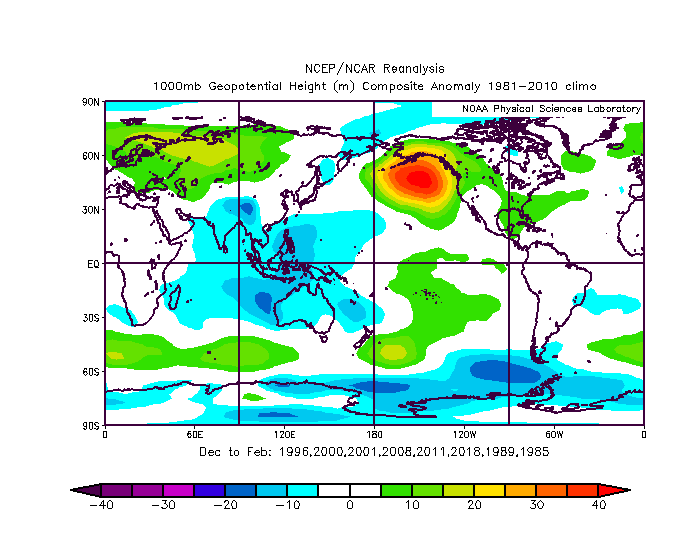
2 hours ago, raindancewx said:The SOI has been pretty negative for a few days now. I don't think this La Nina is super well connected to the atmosphere yet.
We certainly see ECMWF go with a positive Equatorial Southern Oscillation, that matches with an atmospheric Nina going forward. So there is a case for seeing a proper atmospheric Nina....
-
15 hours ago, snowman19 said:
Just out of curiosity, what makes you say this looks like a modoki La Niña? It looks like a basin-wide event to me for sure, not so sure about it looking modoki though. The new CANSIPS would agree with a stronger La Niña:
Certainly at this very moment, it looks basinwide, but the forecasts I am seeing for winter and base my preliminary analysis upon (specifically EC) are looking at a more CP Nina (cooling shifts away from ENSO 1+2).
-
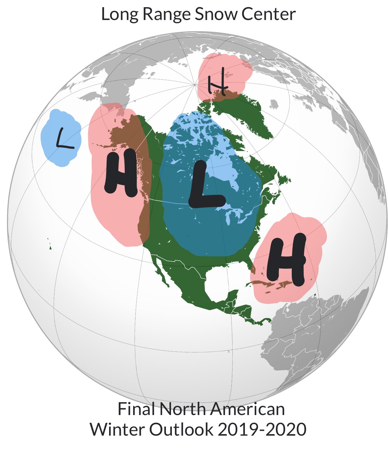
My first seasonal prediction for the NH this season:
Western & Central US and the Northern Alps to benefit from a Canadian Vortex/Aleutian High and +NAO driven weather outlook for the winter ahead from the preliminary look of factors (still got more to look at in coming weeks...).
Not looking so good for the Eastern US under this pattern, climatic factors not stacking up well for the Mid-Atlantic.-
 1
1
-
-
G’day everyone,
My first seasonal prediction for the NH this season:
Western & Central US and the Northern Alps to benefit from a Canadian Vortex/Aleutian High and +NAO driven weather outlook for the winter ahead from the preliminary look of factors (still got more to look at in coming weeks...).
Not looking as great for the Eastern US, could be okay for New England (compared to the Mid-Atlantic). -
Just an extract from my early seasonal update about ENSO, thought the analog might interest some. Text not entirely relevant to the US, worthy of note on the analog is the SE ridge that comes along with it.
QuoteWe are arguably looking at a more Central Pacific or Modoki based Nina if we are going to take this for face value. There is some research backing stronger precipitation in the Japan region during the winter during a Nina Modoki. But in general we see conditions from a Nina that favour snowfall in the Northern parts of the US and Canada. And for Europe, we see a +NAO type set-up, so wet for the UK and Northern Europe, snowy for the Northern Alps, and less snowy for the Southern Alps.
I took a wide selection of Nina Modoki/Central Pacific years, and we see pretty similar themes. A strong Aleutian high, which pushes troughing into Northern and Western North America. A strong +NAO and therefore jet stream coming off the NA Continent towards the UK and Europe. And finally a +AO, indicated by the trough over the Arctic. All this points to a strong snow season for the Western and Northern US, as well as the Northern Alps.
-
1
-
-
https://longrangesnowcenter.net/2020/02/16/north-america-on-the-long-term-16th-feb/
My final long range snowfall forecast for the season. Looks to continue to be bleak for the Eastern US (Mid-Atlantic included) unfortunately. Similar negating factors as there have been all winter.
I also verified my seasonal forecast from November. I predicted an average season, that ended up being below average for the Northeast coast. The interior didn’t do much better either.
-
https://longrangesnowcenter.net/2020/02/16/north-america-on-the-long-term-16th-feb/
My final long range snowfall forecast for the season. Looks bleak for the Eastern US unfortunately. Similar negating factors as there have been all winter.
I also verified my seasonal forecast from November. I predicted an average season, that ended up being below average for the Northeast coast. The interior didn’t do much better either.
-
https://longrangesnowcenter.net/2020/02/16/north-america-on-the-long-term-16th-feb/
My final long range snowfall forecast for the season. Looks bleak for the Eastern US unfortunately. Similar negating factors as there have been all winter. New England might be able to do better in the next two weeks or so, compared to further south.I also verified my seasonal forecast from November. I predicted an average season, that ended up being below average for the Northeast coast. The interior didn’t do a whole lot better either.
-
2 hours ago, Ralph Wiggum said:
Did you just throw out a "fortnight"? Aside from the video game I haven't seen that term used in meteorological discussion in a....yeah.
Lel, it’s probably used more here in Australia.
-
1
-
-
https://longrangesnowcenter.net/2020/01/22/north-america-on-the-long-term-22nd-jan-2/
The latest blog update for long term snowfall prospects for North America from my perspective.- PNW/BC/Northern Rockies to remain good for the next fortnight, reducing in the second week of Feb.
- California/the SW/Southern Rockies to improve for the latter half of February (maybe a bit earlier)
- Eastern US expected to improve for the last 15-20 days of February (2nd-3rd weeks of Feb, possibly into the 4th week) IMO.
- These impacts may be reduced/weakened by Arctic influence, etc.
-
1
-
 2
2
-
https://longrangesnowcenter.net/2019/12/30/north-america-on-the-long-term-30th-december/
Looking like a decent chance of snowy weather for the region around the 6th-9th of January, then ridging through mid-January. Potential for more snowfall in early February, per the pattern cycle. More details on the drivers and analysis above
-
https://longrangesnowcenter.net/2019/12/30/north-america-on-the-long-term-30th-december/
For New England, I’d expect ridging for the region for mid-January, with the latter half of the month being more conducive to some snowfall activity further north in New England. Potential for snowfall further southwards later in the month, and into February.
-
1
-
-
The latest conclusions from my North American long term outlook:
- After the New Year, we should see deeper cold risks per the GWO cycle for the Central and Eastern North American regions.
- The short term good pattern over the Eastern US will dissipate into ridging in the latter half of December. It might get more interesting in the days prior to January, with the aforementioned colder risk in Jan. This doesn’t mean there is no chance of snowfall, rather it is more limited.
- After the current short term Southern US snowfall risk, chances will be lower until January, or at least the last week of December.
More details here:
https://longrangesnowcenter.net/2019/12/09/north-america-on-the-long-term-9th-december/
-
1
-
3 hours ago, raindancewx said:
Any sense on temperature or precipitation anomalies by month? I.e. what you expect to be the most extreme periods? My stuff implied some pretty powerful cold for a while, but also some early/late winter warm ups.
I’d say for New England roughly:
- Average-mildly below average for Dec.
- Similar, maybe a bit colder for Jan.
- Below average temps in Feb.
I’m going with a reasonably good wider Christmas/NY period (mid-late Dec, maybe into Jan) and improving snow conditions after a potential SSW in mid Jan-Feb at this point. This of course changes.
-
Just now, jaxjagman said:
Well thanks for droppping by and your insight.I'm not familiar with your area in Australia but you guys on fire from the IOD ?
Yes unfortunately. I guess it’s probably more interesting for me to look at your snowfall chances, than the hot summer ahead for myself
-
Hey guys, here is my final seasonal forecast for North America that includes forecasts for the entire continent including down in the SE.
I favour average-mildly above average snowfall for the Carolinas and better further inland you go as well.
https://longrangesnowcenter.net/2019/11/10/north-american-winter-outlook-2019-20/

In terms of your short-term forecast, I can only offer the latest in the EC model, that doesn’t look bad.
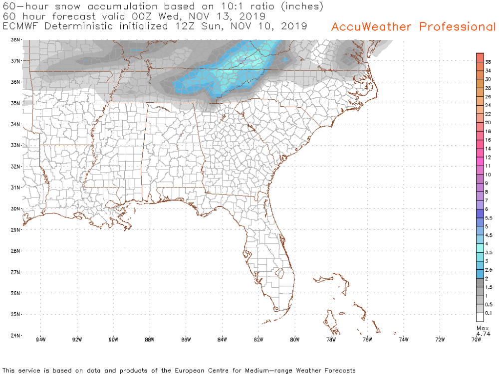
It’s all subject to minor mesoscale trends inevitably, which will pinpoint exact snowfall amounts and locations
-
1
-
-
4 minutes ago, jaxjagman said:
Good luck,still don't know why everyone says this is Modoki when the warmer SST'S are east of the IDL
Thanks
You could argue a lot things about ENSO this winter. Neutral. Weak Modoki (which is what I see). It’s still quite Nina-esque in the extratropics. And some people are calling it a “solid Nino”. But honestly and I try and convey this in the outlook with the use of other drivers, it’s not awfully important the exact definitions of the ENSO at an oceanic level. -
G’day everyone.
I would just like to present my final seasonal outlook for the North America, which includes driver discussion and analysis for patterns that run downstream to the Tennessee Valley. And it’s looking pretty cold and snowy down your way IMO
https://longrangesnowcenter.net/2019/11/10/north-american-winter-outlook-2019-20/

And it’s probably why the region is getting forecasts of snowfall this early.
- Snowy Hibbo
-
 2
2
-


Winter 2020-21 Discussion
in Mid Atlantic
Posted
In my winter forecast, I have found for an average to slightly above average winter in terms of snowfall for the Mid Atlantic.
Based upon the possibility for a SSW, some positive analogs for ENSO and QBO, decent pre-season snow cover, etc.
https://longrangesnowcenter.net/2020/12/06/north-america-winter-outlook-2020-21/