

kdennis78
-
Posts
37 -
Joined
-
Last visited
Content Type
Profiles
Blogs
Forums
American Weather
Media Demo
Store
Gallery
Posts posted by kdennis78
-
-
30 minutes ago, wdrag said:
Not thinking at all 3-5" of rain in 6 hours. Thinking several events add up, plus a little snow melt & a little frozen ground and ab eve normal antecedent flows/soil moisture. If some of this is snow-ice (which it could be west of I95), then that slows runoff and reduces the potential.
Got it. Just don't need any disasters.
-
2 hours ago, wdrag said:
I haven't looked close, but I think its going to be messy wintry west of I95 starting later next weekend, despite above normal temps (colder part of winter). So yes, we could get to 60F mid or late workweek--- see attached ensemble temps for central NJ We should lose all the snow south of I80 by next weekend. North of I80 it gets complicated by ice. Minor flooding could result on a few small streams by next weekend??? but nothing like we had in early January. Its the following week (late Sunday the 28th-31st) that I think gets interesting regarding all sorts of possibilities.
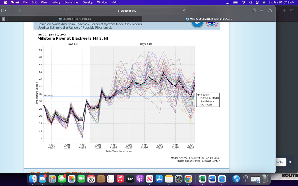
Uh oh. Like 3"-5" of rain in 6 hours with a cutter or coastal storm interesting? My yard is clay soil and nowhere for water to seep down anymore. Simply can't handle that. Not near a river thankfully.
-
11 hours ago, wdrag said:
No more threads anticipated in January with ice-snow next week probably I84 corridor northward.
Monitoring for 2+" qpf the last 10 days of the month pushing us up toward top 10 January prep and also renewed minor flooding in NJ but looong ways off to be sure.
Focus today on whatever occurs in the snow thread. I sure hope Feb produces.
Looks somewhat favorable to me. EC weeklies dated the 18th are focusing in on the traditional Feb 5-15 period. Fingers crossed.
2" QPF over last part of January- Is that a total or are we gonna get a series of coastal and cutter storms that are going to overwhelm us living on saturated ground?
-
 1
1
-
-
20 hours ago, donsutherland1 said:
Right now, it doesn’t look like the area would be pounded by a series of big rainstorms.
Thanks so much. We need a break desperately.
-
 1
1
-
-
On 1/16/2024 at 11:21 AM, kdennis78 said:
For those who understand models and long term forecasting better than I do: Do we see any return to the identical pattern of December and early January with warm temps and relentless and destructive costal low systems that throw down at least 2-6" of rain every three days?
Bump. Any insights?
-
For those who understand models and long term forecasting better than I do: Do we see any return to the identical pattern of December and early January with warm temps and relentless and destructive costal low systems that throw down at least 2-6" of rain every three days?
-
1
-
-
I'm getting lost between the two storms. For the Jan. 9 - 10 storm, is anyone getting anything frozen? What are the average rain totals looking like for that storm at this time? What are going to be the extreme maximums with that storm as predicted now? Are we getting 3-4 hours of consistent heavy rain like we have been getting?
Sorry for the questions but I don't have model access and I'm getting lost with both storms in one thread.
-
9 minutes ago, Tatamy said:
06z Gfs has a flatter weaker system. Of more interest is the system for the 10th. Twenty four hours ago this was being portrayed as a big soaking rainstorm. The models are now showing a system that provides a significant front end dump of snow to some well inland areas before a change to rain. This evolution has been quite interesting to watch. Coastal areas are all rain with this one.
What's well inland? I honestly would welcome snow or even ice over rain. My yard can't handle more rain.
-
Are there any indication on the amount of rain we are getting in one week? Is it going to be December 10 or 17 or 28 all over again?
-
1 hour ago, NEG NAO said:
Not at the moment - recent model runs show a suppressed pattern next week - lets see if that changes at 0Z

I'm sure that it will because we can go without punishment.
-
1
-
-
Are we now looking at another 2"+5" of heavy rain in less than 2 hours again for the mid week?
-
I'm sitting at 2.65" with at least two hours of .65"-.80"/hr rates. For the month of December I am at 10.85". I can't take more rain. Are we done for a while? There is no where for water to go.
-
49 minutes ago, Stormlover74 said:
At least 1 perhaps up to 3" in spots
I can't take this shit anymore
-
2
-
-
What about NW NJ, like western Morris and northern Hunterdon?
-
When the rain is heavy what rates are we talking about here? I don't live near rivers or streams but I'm petrified about flooding in my yard or it getting in the house.
-
Anyone have a good pulse on what to actually expect Tuesday night through Thursday morning (Dec. 27-29)? I'm in Morris County and I'm sweating bullets over the rain coming. How much are we looking at in a practical sense?
-
43 minutes ago, wdrag said:
Good Wednesday morning American Weather participants! It is Dec 20.
Not starting a thread yet for Dec 27-29 which should include a soaking rain (27th) of 3/4-2", and maybe a touch of snow (29ish?). Want to see how this evolves and see if it's worth a thread.
Adding some closing data to the past storm thread.
Make this a good day despite the least snow extent in North America the past 20 years (nice previous post on this). We should eventually need snow sticks for the driveway, shovels for the walk and I hope snow blowers can handle the wet snow on the driveway. I put my faith in that something has to happen in the El Niño pattern once January rolls around.
Are we looking at a long term event to get 2" or are we looking at an ocean storm with heavy rains, slow motion and more flooding across the area?
-
So the area is showing rain on Tuesday next week. Any insight into the scope of the rain, and if we are getting intense, more than a half inch total rain?
-
1
-
-
So are there any minor storms and deluges coming before New Years Day? Are there any long range coastal storms or back to back major rain storms on the horizon? I can't take this anymore. I need a break and a few weeks, if not months, of zero precipitation.
-
I also hate to be a IMBY but what is the rainfall we are looking at in western and southwestern Morris County, NJ? Thanks for any insight
-
Is northwestern NJ getting f$@#%d with more heavy rain on Friday and Saturday? Does anyone have any idea for totals at the end of the system on Sunday?
-
Local mets are all over the place with rain for the Mid-Atlantic and Northeast. Is it possible to get a good handle on the amounts we could see in northern NJ?
-
 1
1
-
-
14 minutes ago, hickory said:
Mods delete this if you want to. Look am not a meteorologist nor do I claim to be, but the consensus is getting clear. There is a constant east in the tracks. If the euro goes east again tonight then that's a sign. You have a powerful Hurricane that will tend to pull more to the north. Also given climo in perspective it wouldn't make landfall at all. Am looking at a cape lookout north landfall. I wouldn't be surprised if it just brushes the OBX and OTS. It's not making landfall in SC or south of cape lookout. You have to follow the trends and its east! Models will wobble back and forth every run, but look at the trend. I would bet $1000 doesn't make landfall west of cape lookout and am willing to put my honor and name to it. Rant over!
If you're not a meteo then don't speak with this kind of authoritative tone. Seems like a garbage post to me.
-
1
-
1
-

March 2024
in New York City Metro
Posted
How bad is this rain coming this week, in each instance? Are we looking at the December abs January storms each time for the next two weeks?