
cardinalland
-
Posts
231 -
Joined
-
Last visited
Content Type
Profiles
Blogs
Forums
American Weather
Media Demo
Store
Gallery
Posts posted by cardinalland
-
-
1 minute ago, eyewall said:
I was curious if anyone here saw shadow bands just before totality. Some people around us say they did.
I saw them in Lyndon VT. SO cool.
-
 2
2
-
-
I like the ridge axis just west of new england. a good sign for this area although not a guarantee
-
looks like 7-8 inches on the ground in new haven. in line with the spotter report of 8”. snow stopped just after 1 and there’s already a little melt commencing. nice storm though
")
-
1
-
-
3.8 in new haven. 1.4 in last hour
-
heavy rates with low visibility and more on the way. everything snow covered including the street. everyone’s thanking this pope fella so i’m gonna thank him too
-
 1
1
-
-
wow ripping snow in new haven. pretty heavy. gonna go out to measure in a few.
-
i remember a lot of folks saying “winter is over” around january 15th 2018 and look at what we got
next 2 weeks do look AN though, only a tiny window around the 30th for potential snow
-
about 0.6” in new haven. accumulated on most surfaces, except those with a bucketload of salt on them…
-
4 minutes ago, ma blizzard said:
gotta give credit to the models that showed the potential for 0.1"-0.25" QPF as freezing rain .. looks well on the way to verifying
definitely verifying in new haven. we’ve got 0.2” of ice on top of the snow and it is rock solid
-
1
-
-
there’s a solid layer of ice here in new haven now on untreated surfaces. the ice threat was definitely real
-
19 minutes ago, Dark Star said:
Yesterday, Edmonton was 4 degrees F and forecast to rise to 15F today, but then drop off into the negative teens Thursday and Friday. Below average fer sure, but not sure if this is cold enough once it travels south and east?
i’m seeing -30s for lows friday and saturday in edmonton. i think that could do the job
-
1
-
-
2 minutes ago, snywx said:
BOM? I’ve seen this referenced lately
(national) blend of models i believe
-
 2
2
-
-
I am on the UWS and did not notice anything from this earthquake. but I don't recall ever feeling the shaking from one so i don't know what to expect
-
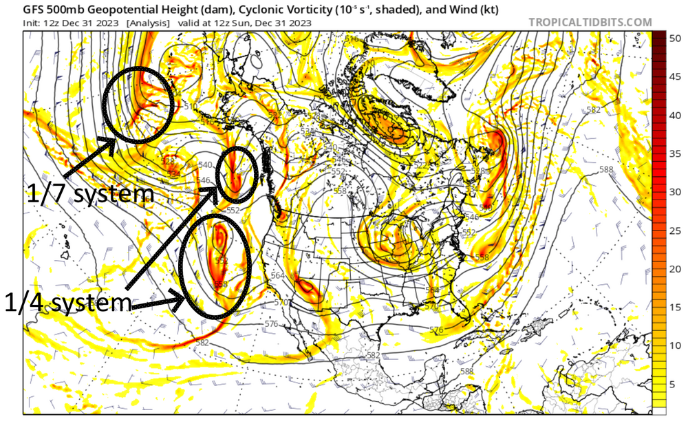
UKMET output looks fairly similar to CMC. less amped than the EURO 00z which is ideal (at least up to h144)
-
4 minutes ago, WinterWolf said:
Ya but on Friday we had the whole month of January gone…so I’m not sold on anything yet, let alone something at 11 days out. But I know you were just commenting on one run of one model.
yep, and i'm intrigued by the period after 1.10.24 as well. looking like a big change from the nationwide decembtorch
-
5 minutes ago, EastonSN+ said:
This can be a decent event for the coastal plain with the cold air just to the west moving in.
it would be interesting if a storm formed off that cold front, i know that kind of setup has delivered before
-
2
-
-
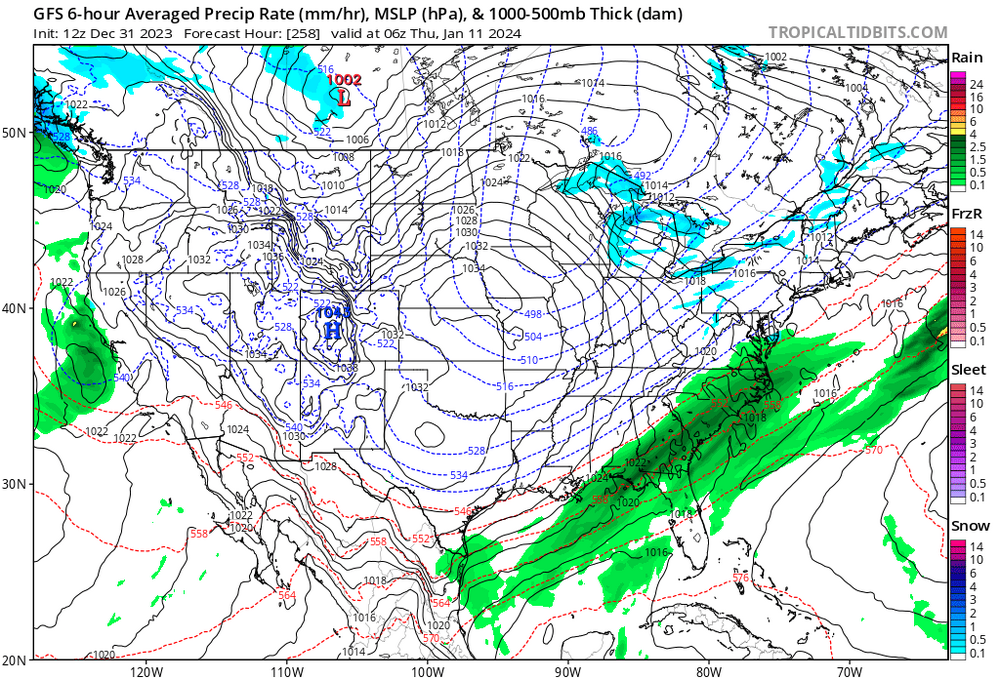
1/10 storm is a rainer to mainer on GFS. high in a worse location
-
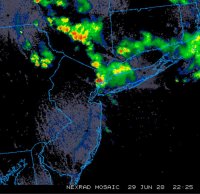
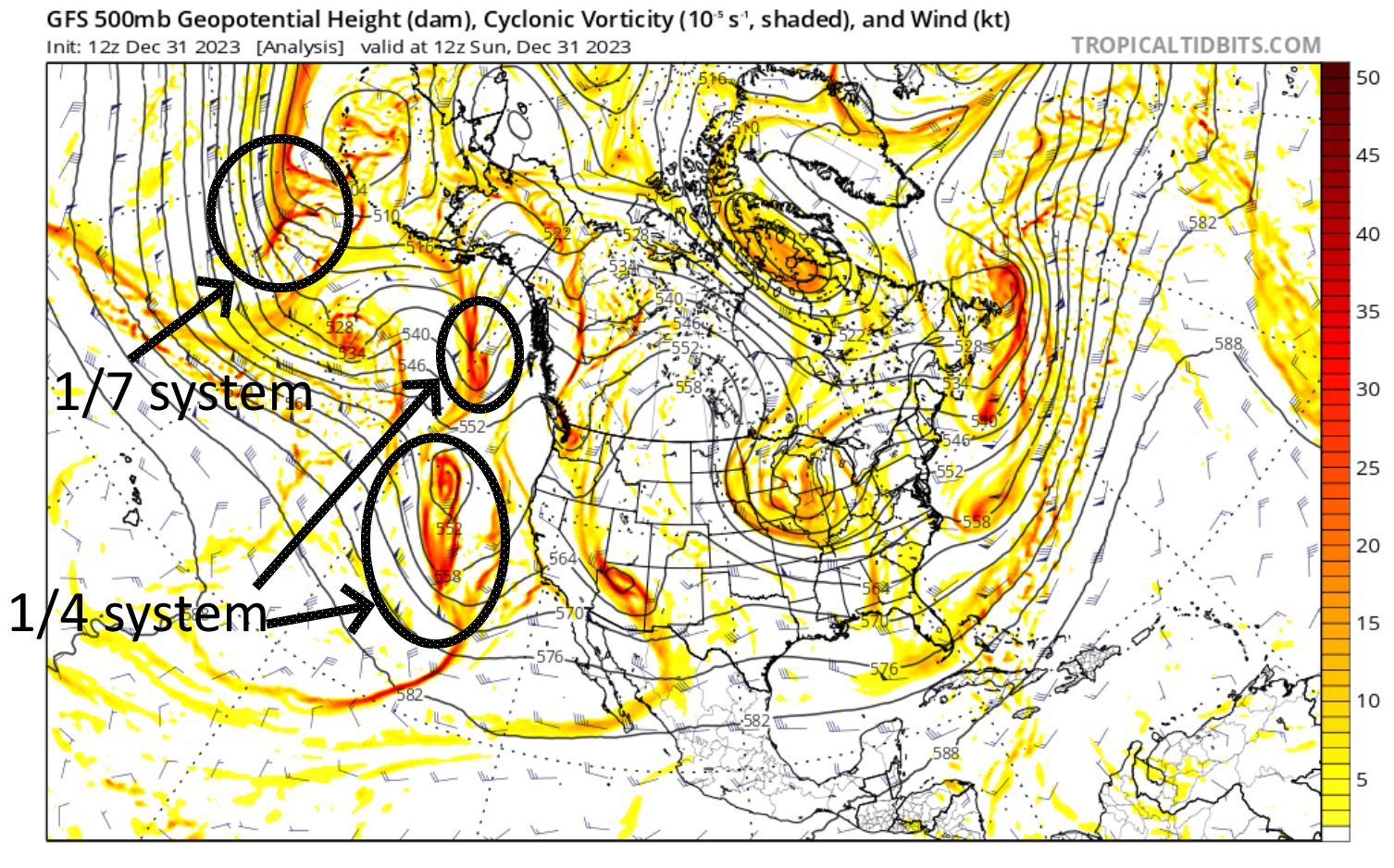
traced the storms back to the present/hour 0 and they are still quite far away at present. don't know enough to determine how this impacts prediction, but wanted to share anyways
-
1
-
-
verbatim 12z GFS crushes NNJ NYC SNE. gotta keep an eye on that north trend though
-
1
-
-
storm more amped through GFS hour 165. hopefully this doesn't become another cutter

-
there's a legit 50-50 low on GFS for 1.7.24
-
1
-
-
beautiful spring day today
-
last strong niño wasn’t too far off in most of the region. definitely less snow in 2023 up north though. and in N Central US
-
3 hours ago, BrianW said:
Looking forward for my first 20s of the season...
Lows are expected to be in the low-20s/upper teens for most. The NYC metro will be be drop into the upper-20s while far interior areas may see mid-teens. These temperatures are only a few degrees to 5 degrees below normal, but still some of the coldest we have seen thus far this season.
that’s odd in new haven/west haven we got a 29 on like november 2 i believe. it was an impressive frost
edit missed the 10 comments on this lol

April 2024
in New York City Metro
Posted
Mid 50s behind the backdoor here in southern Connecticut