

Hurricaneguy
-
Posts
73 -
Joined
-
Last visited
Content Type
Profiles
Blogs
Forums
American Weather
Media Demo
Store
Gallery
Posts posted by Hurricaneguy
-
-
All final hi res still showing mixing issues through the valley later this evening. Not holding my breath. See y'all later. Good luck
-
 1
1
-
-
At this point nothing is really changing minds we might be in for a pleasant surprise tomorrow. I was hoping for a late positive model trend. Guess we just watch in the real time now.
-
10 minutes ago, jaxjagman said:
GFS is locked in

Mixing issues East TN not as bad as the NAM but they are feeling good about it
-
When I was at UT, every snow would always be better in the Tri Cities and east of Knoxville. Knox County was a major snow hole. Now in the last several years those places have switched roles.
-
1
-
-
The NAM wants to keep ruining the party. It's staying locked in.
-
1
-
-
3 minutes ago, TellicoWx said:
I get an inch on that hrrr run...it's locked in...book it

-
 4
4
-
-
1 minute ago, tnweathernut said:
Those downslope holes are still around 2 inches, FWIW.
True, but when you've been deprived seeing a good >5" snow event at your house in over ten years it gets old. Last year broke me lol
-
2
-
 1
1
-
-
7 minutes ago, Carvers Gap said:
12z NBM
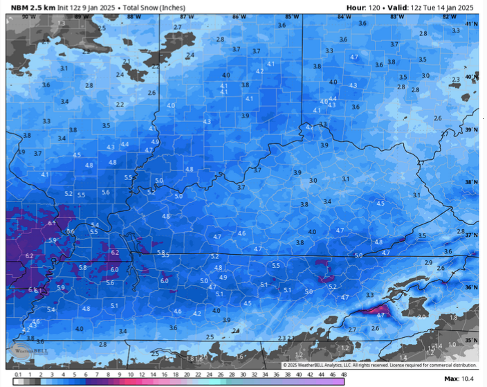
That scenario is identical to last year's event for Greene Co. Sharp cutoff mid county due to mixing issues. We've on average had less than most places in East TN but the last few years have been worse than normal. New normal I suppose.
-
2 minutes ago, dwagner88 said:
That ARW run winds up with 5-8" south of 40, but I don't think it's done snowing in NE TN yet at the end of the run. Still doesn't like Greene county all that much. Downsloping I suppose.
 Sigh
Sigh
-
2
-
-
3 minutes ago, Vol4Life said:
Man…can’t get so depressed off of one model run…especially the NAM. All other models have been trending great this evening.
I read the 0z suite would have the best data yet. HRRR and NAM have changed horribly. I’ll wait on the others but if Icon, GFS, etc fall apart this bad it’s not gonna end well
-
1
-
-
NAM disaster. If the rest of the 0z follows suit then folks I think it’s about time to say next.
-
2
-
-
00z HRRR horrible for East TN. Major mixing issues especially as the system exits. Not good
-
2
-
-
9 minutes ago, John1122 said:
I still wouldn't be surprised to see that 6 inch area get bigger.
Sorry I had to


-
1
-
 1
1
-
8
-
 1
1
-
-
6 minutes ago, midwoodian said:
When you’re saying 81, do you mean I-40? 81 ends northeast of Knoxville and is a north south artery.
.More areas south of 81 until it meets the split at 40. Specially Cocke, Greene, Washington, etc
-
1
-
-
I expect MRX to continue to trend down for the area south of I81. Even with the newest HRRR in range, it shows a brutal snow hole over parts of Greene and Washington Co. Mixing issues. Just unbelievable the luck. We've not had a 6"+ snow since 2014. Last decent snow was the Christmas Eve fun 2020
-
3
-
-
Nothing has changed my mind yet on mixing issues for areas south of I81 in East TN. Still thinking 1-2'' max for those areas assuming slush doesnt wash most away like last year.
-
Models seesawing across the region. Beginning to feel less confident in anything decent for East TN. 2” if we are lucky. I just think mixing issues are going to show per usual. Hopefully we have enough room for another good opportunity.
-
9 minutes ago, tnweathernut said:
More of a microclimate thing, Jax. Unicoi, Greene & parts of Washington County tend to pull downslopes and dryslots like a magician pulls a rabbit from a hat. It's a talent we have in spades.
For real! I'm mega scarred from last year's letdown in Greeneville. Everyone celebrating while I'm surrounded by slush. I'm cautiously optimistic for Friday. Honestly dont even know if I can get excited this time until the ground is completely white. Last time that happened March surprise storm 2022 btw
-
1
-
-
Fully convinced this will be a whole lotta nothing for East TN. I was in the warm nose last Jan. Still salty about it. Winters are just not the same anymore.
-
2
-
 1
1
-
-
After my snow dreams were crushed by the warm nose yesterday I’m not betting against the models showing the warm nose again this Friday. Not getting burned twice in one week. Hope we get a nice surprise.
-
1
-
-
It's been snowing steady all morning here in Greeneville. Ironically I think I have more snow this morning than all yesterday combined.
-
2
-
-
5 minutes ago, Dsty2001 said:
I just don't get it, even with the heavier bands we get a few minutes of big fat flakes coming down hard then it's as if the heavier bands break up over my area and it transitions back to light drizzle. Officially throwing the towel in, travel around here is going to be treacherous though with all the water and slush freezing tonight
This ranks to me as one of biggest busts in memory for Greeneville. So frustrating especially when we see all the amazing totals from areas nearby. Would be lying if I said I wasn’t mad.
-
2
-
3
-
-
3 minutes ago, Dsty2001 said:
It's finally staying all snow here
I'm glad to hear that! Wild that it's still rain here and we are only four miles apart
-
Still rain here in Greeneville. I'd imagine we are in the running for the bust award for this system. Western and Northern Greene Co have healthy 4-5'' totals. What a total warm nose screw job lol
1-10-11-25 Western Whopper, Mid-state Masher, Foothills Finger? OBS/Pics
in Tennessee Valley
Posted
Finished with 3” in Greeneville. All and all not bad. Still not what I hoped but did well overall in comparison to the region and way better than last year.