

Jtm12180
-
Posts
70 -
Joined
-
Last visited
Content Type
Profiles
Blogs
Forums
American Weather
Media Demo
Store
Gallery
Posts posted by Jtm12180
-
-
6 hours ago, WxWatcher007 said:
Yeah I’m not really sure what to think. The ensembles were split between the op and a more progressive track.

That would be an absolutely catastrophic scenario for my neck of the woods…damn
-
-
3 hours ago, Floydbuster said:
I agree. I don't think Dorian gets the respect it deserves.
Sadly, because it didn’t hit the East Coast. 90 miles further west and it would've been talked about forever…
-
39 minutes ago, cptcatz said:
Lololol NHC literally said "no way Jose" in their discussion.
But back in topic, GFS and Euro ensembles bring this MDR system awfully close to the east coast. Looks like we could get the first legit long tracking CV storm to threaten the US since... Irma?
Yeah just saw that myself...
-
31 minutes ago, Mowfishin said:
I'm in McClellanville with a house on ground level on the creek. Certainly a little concerned at this point
Did you live there in ‘89?
-
A lot of people been calling out others with their “schlong” ratings on posts about a potential cat 5…hopefully those will quiet now because Ian basically for all intents and purposes a cat 5
-
10 minutes ago, Hotair said:
Try as I can I still don’t see a NÉ component to motion on radar. Sort of straight North. Is there a loop that shows this better? I’m going by keys radar
Nah…Key West radar is as good as you’ll get. It’ll clear up more as it gets closer to KW
-
Levi has been saying for two days that it wasn’t going to be until Ian was in line with Jamaica’s longitude for it to start to get its act together.
looking like the guy was 100% spot on…
-
Not too bad here just west of Myrtle Beach. Not sure how much this would be considered.
roads were a little wet this morning but no ice. Bridges had some slush on them and wheels wanted to lock up when i hit brakes on bridge but going over cautiously caused no issues
-
1 hour ago, goldman75 said:
Here in Myrtle beach I’ll take that all day long over all freezing rain!
YEP!!!!!!!!!!!!
-
2 minutes ago, Sandstorm94 said:
The SC low county had 14 ensembles with an ice storm counting the 0P... Yikes
Sent from my SM-S115DL using Tapatalk
PLEASE…not this!!! That ice storm we had in ‘14 was nuts. Usually here we get winter weather and then the roads are dry by 3pm. Our whole area was paralyzed for a week.
i can handle snow all day. But ice? Like the saying goes…”ain’t nobody got time for that!”
-
 1
1
-
-
8 hours ago, ncforecaster89 said:
Completely concur with this assessment, unfortunately, as I’d like to see an East Coast landfall.
Edit: But, there’s a reason I very rarely comment on a solution beyond 5-7 days. Specifically, there’s ample time for the synoptic pattern to change just enough to effect the eventual track. For those, like myself, who desire an EC strike, the current deepening trend is not welcome news and will likely mean a further N propagation of the track as it passes the Islands.
trust me, I get it with wanting to see a hurricane, but wishing for one to hit you is just dumb.
tell you what, if we get a cat 4 here in Myrtle Beach, come pay my deductible on our house if the roof goes
-
 1
1
-
 1
1
-
-
8 hours ago, Ed, snow and hurricane fan said:
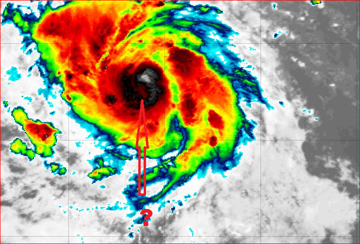
I think I see a warm spot starting to develop on the IR where one would expect an eye to appear looking at Trop. Tidbits. Have read the posts after I got home from work and seen the guidance, this is obviously probably not an ECUSA threat, or interest may drop, but a classic major hurricane, well, Isabel, I downloaded loops on a 56k phone modem when she was at peak, as I get older, enjoying hurricanes is getting easier.
Kids today don’t even know the struggle of dial-up…nor the god forsaken noise when dialing/connecting
-
3
-
1
-
-
3 hours ago, WxWatcher007 said:
Totally agree. This will be a major.
Chaos when I don’t start the thread

Busy day guys….got on here to do it just now.
-
1
-
-
Latest euro showing Sam coming to at least high-five the southeast
-
GFS and Euro currently in agreement of something significant in Western Atlantic 10-14 days out...fwiw
-
1 hour ago, janetjanet998 said:
ULLETIN - EAS ACTIVATION REQUESTED
TORNADO WARNING
NATIONAL WEATHER SERVICE TALLAHASSEE FL
1211 PM EDT THU APR 23 2020
THE NATIONAL WEATHER SERVICE IN TALLAHASSEE HAS ISSUED A
* TORNADO WARNING FOR...
NORTH CENTRAL GRADY COUNTY IN SOUTHWESTERN GEORGIA...
SOUTHEASTERN MITCHELL COUNTY IN SOUTHWESTERN GEORGIA...
NORTHERN THOMAS COUNTY IN SOUTH CENTRAL GEORGIA...
NORTHWESTERN BROOKS COUNTY IN SOUTH CENTRAL GEORGIA...
COLQUITT COUNTY IN SOUTH CENTRAL GEORGIA...
* UNTIL 1245 PM EDT.
* AT 1211 PM EDT, A CONFIRMED TORNADO WAS LOCATED OVER PELHAM, MOVING
EAST AT 55 MPH.
HAZARD...DAMAGING TORNADO AND QUARTER SIZE HAIL.
SOURCE...LAW ENFORCEMENT CONFIRMED TORNADO.
my stepson's family all live around Moultrie, GA. He talked to them a few minutes ago and said there were some trees/branches down, but it doesn't appear that it was anything too major
-
Let 'er rip...

Major Hurricane Helene
in Tropical Headquarters
Posted
And there's no way 130mph will be the ceiling IMO...NHC is so hesitant to forecast intensity even when all the proof is there that conditions are going to be ideal