

Cerakoter1984
-
Posts
303 -
Joined
-
Last visited
Content Type
Profiles
Blogs
Forums
American Weather
Media Demo
Store
Gallery
Posts posted by Cerakoter1984
-
-
I fully expect to see an interesting storm in our area near Thanksgiving.
-
2 hours ago, WhiteoutWX said:
00z GFS continues with an extremely impressive blocking pattern in the long range. By the end of the run has TWO closed upper highs in Canada/Greenland with the PV basically trapped over the Great Lakes. Given support from the GEFS and the Euro/EPS this is about as encouraging a sign as one can get for cold/snow at lower latitudes, especially if we can keep this blockiness into December.
Yes. Going to be hard to see a late fall pattern better than that. When retrogression begins,.... boom. This winter could be pretty historic. Too many dominoes falling in a row for it not to. Looking forward to writing about a lot of exciting weather this winter. Really haven't had much weather to write about around here in nearly 3 years.
-
 3
3
-
-
6 hours ago, WhiteoutWX said:
Building consensus for a period of increased blocking in the 7+ day range. Currently the position of the block looks to focus the core of the cold to our east but overall I’d say blocking showing up is a good sign heading into winter. Definitely a completely different look than the past couple Novembers.
We're heading into a pretty good spot for being November. Hoping for a bit of retrogression after this pattern sets up.
-
15 hours ago, raindancewx said:
I'm somewhat familiar with ONI/PDO/AMO/Solar values for years before 1950, but I generally forbid myself from using anything before 1931 because there is no snow data for where I live, so its kind of pointless to look at for me. But I did want to ask you...what do you like about 1917-18?
N. Pac configuration and solar mostly. It was a strong La Nina but it fits an overall pattern of years similar to 2010-11, 1988-89 also. There's some huge potential for major pattern amplification and blocking once we get a little way into winter and all throughout the rest of it. That also shares the characteristics of 1917-18.
-
1
-
-
On 11/1/2017 at 0:05 PM, MoWeatherguy said:
Hard to get excited about snow around here anymore. Last day in Fayetteville with greater than .5 snow was back in March 2015. SMDH
I believe this year will be 100% different than the last 2. I think that we are in for a pretty wild winter around these parts.
-
1
-
-
12 hours ago, raindancewx said:
Any of you use Weather Trends 360? Don't subscribe, but they linked this on Twitter yesterday - thought it might make some of you happy.

It makes me really happy but also disappointed. 200% more than last year is still below normal. Lol
-
Gonna throw this map up. I'm still leaning pretty hard towards this.
-
November looks seriously a lot like early winter from where I'm sitting.
-
1
-
-
On 10/23/2017 at 3:36 PM, raindancewx said:
I dunno if the "snow" anomalies I'm linking include sleet/freezing rain, etc, but this forum region did pretty well in terms of snow anomalies in a lot of the winters I like. If SSTs mean anything, its a good sign, since the blend is very close to current conditions.

Sanity check for analogs in Oct of analog year v. Oct 22 2017:

Looks like I would have gotten snow in about two of those really. Talk about winters of being one county away from the fun. Yikes!
-
Things looking to take off pretty fast over the next few days. Very reminiscent of 2000 and 2013 in my opinion.
-
On 10/5/2017 at 5:12 PM, raindancewx said:
I want to see what the AMO value for September was, but pending a sudden warm up / cool down from the hurricanes, I like a blend of 1932, 1943, 1944, 1996, 2005, 2007, 2008, 2012 for the winter. Tried to pick warm/neutral AMO years, with a mix of positive PDO/negative PDO years, low solar, La Ninas or Cold Neutrals after La Ninas, similar values to what I expect on the Jamstec's Modoki index which goes back to 1870. Also try to blend it all in a way that matches Summer rainfall patterns here, since we get so little rain even in the wet season.
Weighting is something like:
1932: x3
1943: x2
1944: x3
1996: x3
2005: x3
2007: x3
2008: x2
2012: x1
I think it's a much colder, but still not particularly cold winter for much of interior South, South Central, and SW US. 1932-33 was one of the winters that triggered the Dustbowl so hoping it isn't that dry, but with a VEI6 volcano in the tropics, and a hurricane hitting SW FL, a four hitting Puerto Rico & TX, something is similar - whether its Nino 3.4, trade winds, or the Atlantic, its not like Puerto Rico & TX have both been hit by fours in the same year in any other year since 1850.
I'm almost done writing my winter outlook, will put it out sometime between 10/7 and 10/15. Want to see how much rain we have in Oct and a couple other minor things.
I'm looking forward to it. I'm still working and waiting on a few things to happen also before I write my thoughts out. Things are looking good for my area, in my opinion. The next 2 weeks are very critical in the overall long term pattern. Trades burst looks to cool ENSO back down. Something to keep in mind also, +AAM, -QBO, and a climbing PDO all argue for a -AO and a period of at least some cold for a large portion of the US this winter.
-
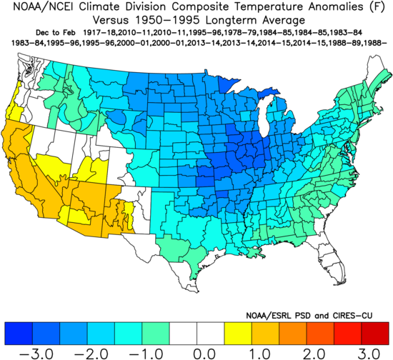
I'm going with a slightly harsher scenario (cold) than most. I like 2000-01, 1984-85, 2008-09, and 2010-11. Going to get into research pretty quick and see if i can make an analog map or 2.
-
2 hours ago, donsutherland1 said:
You can find the data here: http://ocean.dmi.dk/arctic/meant80n.uk.php
Thank you.
-
3 hours ago, qr7121 said:
this is horrifying

Where can I find that chart? That's a neat way to look at the temperatures.
-
Is there a possibility of an inter-hemispheric temperature variability cycle coming into play here? Basically south pole warming and north pole cooling in the near future? May be a stupid question, but when you see weird stuff, is there a better time to ask a weird question?
-
On Monday, September 19, 2016 at 7:19 PM, lookingnorth said:
89/72/96. This is horrible second half of September weather.
Agree. I'm sick of it.
MO/KS/AR/OK 2019-2020 Winter Wonderland Discussion
in Central/Western States
Posted
Getting there...
If the Euro is too warm and too far West with the cold here, then I think we may have a candidate for a storm of some interest.