

Cerakoter1984
-
Posts
303 -
Joined
-
Last visited
Content Type
Profiles
Blogs
Forums
American Weather
Media Demo
Store
Gallery
Posts posted by Cerakoter1984
-
-
SST profiling and persistence would say that I'd bet on more than a week of what we all had down here last season.
Niña signature isn't necessarily the attention getter here, in my opinion, as much as the hard contrast off Baja and the strengthening warm mode in the N. Pac.
-
Haven't been around these parts in a good minute or 3. Looks like winter is here.
")
Been a long time since having a major event to look forward to. Hope everyone has been well.
-
 4
4
-
-
On 1/23/2020 at 9:31 PM, The Waterboy said:
Here’s some interesting history for you for Fayetteville snowfall over the years. Maybe this helps you feel better. Or not...
Here are the top 4 maximum snowfall years since records started in 1949.
1. 27” in 2010
2. 23.5” - 1978
3. 20.5 - 1960
4. 20.4 - 2011
That means 2 of the top four record years were within the last 10 years.
Unfortunately 3 of the bottom 7 years have occurred since 2012. And 8 of the bottom 10 have occurred since 1998.
2 inches a year keeps you out of the bottom 10 so it doesn’t take much.
Having lived through 2 of the 4 best plus the most historic ice storm (in this area, 01-27-2009) of a century and then the weekly blitz that was 2013-14 to end that era, I guess it became pretty hard to remember that a 3" snow here was still pretty special when I was a kid. Also that an 8"+ winter with 2 or more mid to major events rolled in was considered one we'd remember for a long time.
What a crazy decade of winters we just walked out of if you think about it.
In like a lion in 2010, out like a lamb in 2019.
Here's to winter coming back over the next 2 years.
-
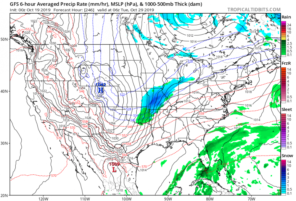
Models have anywhere from slop to up to 3 in with elevation. Should be interesting.
-
I miss having snowstorms to talk about for days. Even fake ones. If I'm not in here before January 1st, Happy New Year.
-
1
-
-
On 10/23/2019 at 9:24 AM, JoMo said:
Keep seeing people mention 2014 and 2004 a lot. Disappointing years for snowfall here.
I see absolutely nothing at all that brings reminiscences of either of the 2 years.
My thoughts lean, in terms of actual weather to date, towards a blend of 2000, 2008, 2010 and 2013.
-
11 hours ago, JoMo said:
Too bad the fantasy maps never happen. 12z GFS might have a little rain/snow mix for KS/MO on Thurs night.
I know, but it was fun to post. It wasn't really intended in seriousness.
The upcoming pattern for the next few weeks is pretty nice though. Need it to repeat in winter.
-
Our first fantasy snow map in October. Wow.
-
10 hours ago, raindancewx said:
My analogs had parts of Oklahoma, Missouri and Kansas pretty snowy if you want to see. I included some slides at the end of my forecast about how well I did last year, so you can decide if it is worth paying attention to what I have or not. There is a slide that has snow totals for Oklahoma City, Tulsa, Little Rock and some other towns in the region if you are curious.
I wrote a longer post but it disappeared. Anyway, great stuff raindancewx. I always enjoy the way you approach forecasting. Very thorough. Well done.
-
18 hours ago, ouamber said:
Hi Everyone!!! The cooler weather has got me excited for winter! It better show up in a big way this year! Snow for everybody!


.....and since I'm an alumni, guess what? It's 11:13am and Texas still sucks! #HornsDown #BoomerSooner
Boomer!! We're gonna dominate the little pronghorns today.
Sould be a great game.
Heck of a way to return from hibernation, my friend! Lol
-
IOD, descending QBO, Modoki atmosphere, in spite of what the surface looks like at this time and that HUGE HUGE storm due north all look fantastic for winter implications this year. As JoMo said, though, stuff could change. Seeing signs of a nice looking Bering Sea low developing in the future as well.
I think the signs all point to a go for winter after week three of November down here. That's my honest opinion.
-
1
-
-
Looking forward to the cool blast Thursday and Friday. Should wake us all up a smidge. Glad to see the heat going away.
-
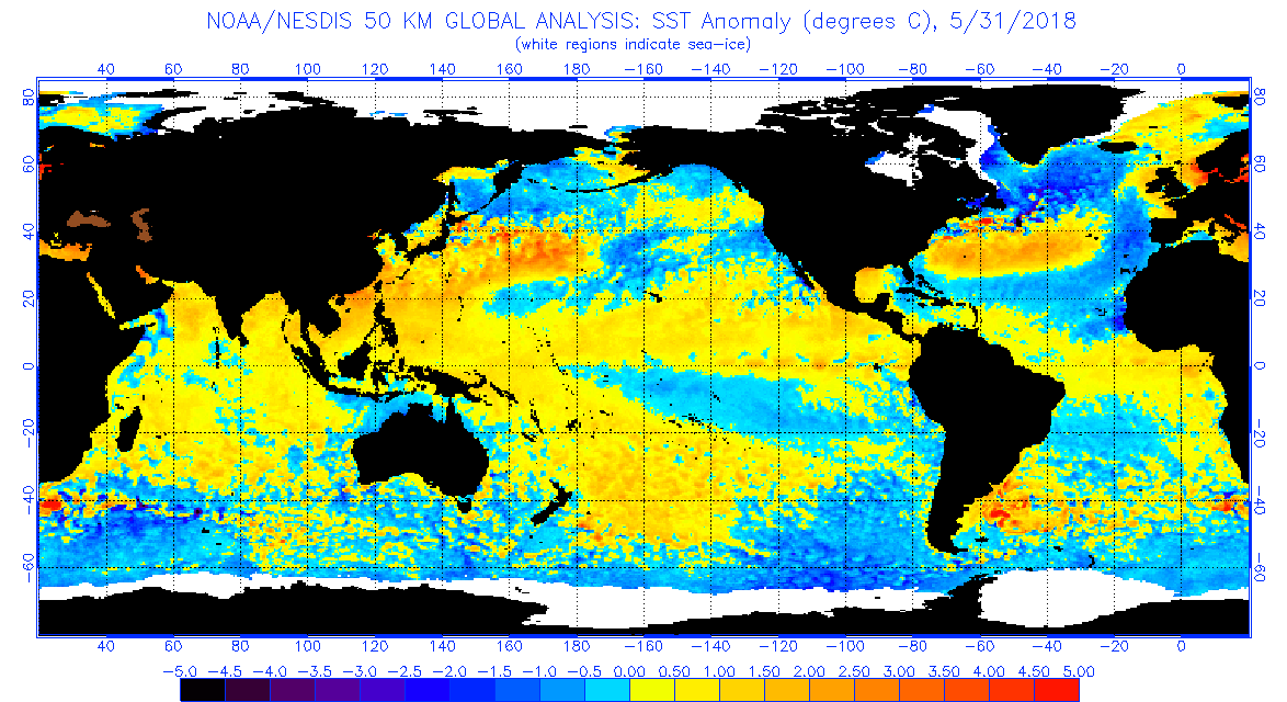
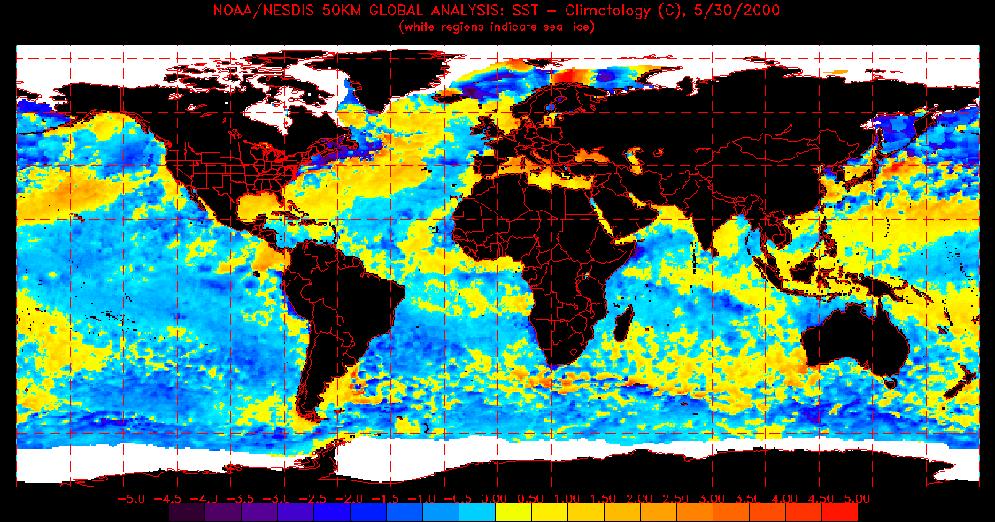
So it would be a safe bet to say that any warming in the eastern Niño regions is temporal at best and should likely see more warming going forward in 3.4?
Also, do you know where a fellow could find SST reanalysis maps going back throughout the 1900s? I used to have a link to them years ago, but I cannot find it now. Thank you. I'm not on here much but I always like to pop in and read your creative, unique, and intelligent approaches to oceanic/atmospheric matters, raindancewx.
-
Hello. Hope everyone is doing well this autumn. It's hot. Can't wait for it to end.
-
I'm not around much on here anymore but good stuff, as always, raindance. I always enjoy the way you think and connect things.
-
Excited to hopefully get to knock out this snow drought. Lowest amounts I saw was 1" for my area so that will work for November 12. Good luck everyone!
-
I'm still here. What's this "snow" you speak of? lol.
In all seriousness, looks like we're not done seeing increases. This looks like a legit warning snow for me if I'm extrapolating correctly.
-
raindance is correct. The upcoming winter, if it errs on the warm side as the Nino forecasts seem to be making it, will be subject to long-term CAD events. (C.old A.ir D.amming) If we err on the side of severe cold, it will be major snow events for most of this area and very prolonged severe cold. If we have that odd situation where the tropics are strong and the cold is locked into the US all winter (think Russia the last 3 seasons), well, use your imagination about the severity of that.
-
Hey all! Looking like a cold finish to October is in store. I'm getting very excited about the prospects of what late autumn and winter could bring to this area. This could likely finish as the coldest 20 days many of us have seen to close an October ever. That's pretty profound if you ask me. I understand that Canada's crops failed due to cold and most of their stuff has happened a month or more early. I'd say we should be ready for a real winter.
-
1
-
-
I'm staying with warm-neutral "head fake".
-
1
-
-
On 8/6/2018 at 9:36 AM, 40/70 Benchmark said:
Assessing an ENSO call in mid summer?
This is what moderators are for.
I was mostly just reaffirming or finalizing my call, not so much assessing. Sometimes I do that so I can't change my mind again later.
-
1
-
-
Had it as a head fake from the onset, may have waffled once but I think my gut made a pretty solid call here. Neutral for the win.
-
-
3 hours ago, raindancewx said:
My analogs had a pretty hot start to Summer in June nationally, then the heat shifts to the NW. We're looking at possibly near record rain tomorrow in NM with high cape values and upper air moisture, and that was kind of my idea for the Summer here - lots of heat early, interrupted by heavy rain, and then once the rain becomes consistent it will be kind of cool v. long-term average highs. June is supposed to be the transition. If the El Nino holds on into winter, I think the SW will be fairly cold, at least for highs, maybe 3-8F colder v. the past winter.
I'm leaning pretty hard towards an Autumn 2000 type weather pattern. It would fit the short-cycling "false Niño" concept that I have pretty well also. Just depends on when it arrives. Early will be a waste and a cold autumn that warms into winter relative to average. Locations of warmest SSTs in both the ATL, PAC and IO are nearly in full agreement with me as far as analogs are concerned as well.

 Hard to spot the similarities because the images aren't lined up well but if you look, they are there.
Severe heat wave July 2021 in the southwest - possible world record
in Central/Western States
Posted
Simply amazing stuff.