NIUmetGF
-
Posts
100 -
Joined
-
Last visited
About NIUmetGF

-
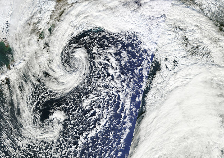
Alaska/Western Canada obs and discussion
NIUmetGF replied to patrick7032's topic in Central/Western States
A little 'instant occlusion' going on in the Northern Pacific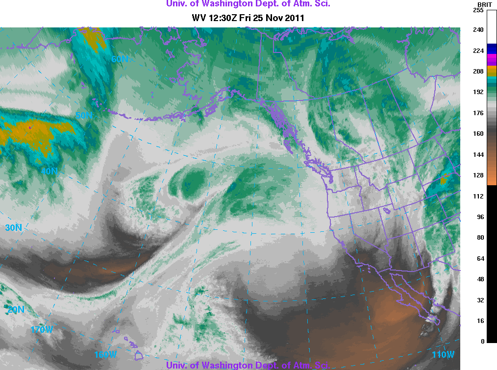
-
Alaska/Western Canada obs and discussion
NIUmetGF replied to patrick7032's topic in Central/Western States
The North Slope and Alaska Range are easily identifiable just from the 850T air pooling upstream of the barriers. -
Alaska/Western Canada obs and discussion
NIUmetGF replied to patrick7032's topic in Central/Western States
Check out those 500mb heights!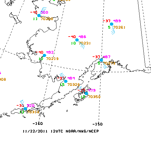
-
Alaska/Western Canada obs and discussion
NIUmetGF replied to patrick7032's topic in Central/Western States
Valdez had sustained winds of 100mph and gusts to 120mph with this event. What makes this event so rare is the upper level winds were from the south! These winds were created by the combination of surface pressure gradient (High over the interior, Low in the Gulf of Alaska) and cold air in the Copper River Basin being held back by the Chugach. The Gulkana(Copper River Basin) to Cordova(Along the coast near Valdez) pressure difference was 22mb! To put it into perspective the models were only forecasting 50kt in the low/mid levels that was available to mix to the surface. Essentially a katabatic driven event! -
Alaska/Western Canada obs and discussion
NIUmetGF replied to patrick7032's topic in Central/Western States
I was just looking at that yesterday. Makes sense when the whole polar vortex displaces over top of you. -
Alaska/Western Canada obs and discussion
NIUmetGF replied to patrick7032's topic in Central/Western States
That's just brutal. We never got anything that bitterly cold in ND till mid-winter. At least the wind doesn't blow much up there. -
Alaska/Western Canada obs and discussion
NIUmetGF replied to patrick7032's topic in Central/Western States
Not quite as impressive as the central Interior, but still cold none the less... ...RECORD LOW TEMPERATURE IN ANCHORAGE AND BITTER COLD TEMPERATURES ACROSS THE REGION... COLD TEMPERATURES ALOFT COMBINED WITH A NIGHT OF CLEAR SKIES AND LIGHT WINDS HAVE ALLOWED TEMPERATURES TO PLUMMET ACROSS SOUTH CENTRAL ALASKA. CLOUDS WILL BE ON THE INCREASE TONIGHT AHEAD OF AN APPROACHING FRONT FROM THE SOUTHWEST WHICH WILL RESULT IN MODERATING TEMPERATURES TONIGHT AND SUNDAY. A RECORD LOW TEMPERATURE OF -8 DEGREES WAS SET AT THE NWS ANCHORAGE FORECAST OFFICE TODAY. THIS BREAKS THE OLD RECORD OF -7 DEGREES SET IN 1963. OTHER LOW TEMPERATURES FROM THE AREA: ANCHORAGE AREA: EAGLE RIVER................................. -26 CAMPBELL CREEK SCIENCE CENTER............... -22 EAST NORTHERN LIGHTS........................ -15 NEW SEWARD @ HUFFMAN........................ -13 ANCHORAGE MIDTOWN........................... -10 ANCHORAGE INTERNATIONAL AIRPORT............. -9 TURNAGAIN ARM AREA: SEWARD HWY @ PORTAGE GLACIER RD............. -16 GIRDWOOD.................................... -7 PORTAGE..................................... -7 MAT-SU AREA: WILLOW...................................... -28 SKWENTNA.................................... -26 BUTTE....................................... -21 WASILLA AIRPORT............................. -20 TALKEETNA AIRPORT........................... -19 SOUTH PALMER................................ -18 WEST PALMER................................. -17 PALMER AIRPORT.............................. -9 KENAI AREA: KENAI NWR................................... -25 SOLDOTNA.................................... -18 KENAI MUNICIPAL AIRPORT..................... -16 NINILCHIK................................... -11 COPPER RIVER BASIN: GLENNALLEN.................................. -38 MAY CREEK................................... -37 CHISTOCHINA................................. -35 GULKANA AIRPORT............................. -34 KLAWASI..................................... -23 CHITINA..................................... -24 MCCARTHY.................................... -22 EUREKA...................................... -15 MTL -
Alaska/Western Canada obs and discussion
NIUmetGF replied to patrick7032's topic in Central/Western States
Nice sun dogs! That was one thing I enjoyed in ND. Lots of ice crystals, light pillars and huge sun dogs. -
Alaska/Western Canada obs and discussion
NIUmetGF replied to patrick7032's topic in Central/Western States
Observations from Palmer AK last evening. They were sitting at -5F at 153Z by 553z they had jumped up to 13F. Mixing anyone? PAAQ 160705Z AUTO 03030G45KT 2 1/2SM BLSN CLR M11/M19 A2973 RMK AO2 PK WND 02045/0659 TSNO PAAQ 160653Z AUTO 03027G49KT 4SM BLSN CLR M11/M19 A2973 RMK AO2 PK WND 05049/0651 SLP070 T11061194 TSNO PAAQ 160605Z AUTO 03029G42KT 5SM BLSN CLR M11/M19 A2974 RMK AO2 PK WND 03042/0604 TSNO PAAQ 160553Z AUTO 03028G42KT 2SM BLSN CLR M11/M19 A2975 RMK AO2 PK WND 03045/0542 VIS 1 3/4V3 SLP074 T11061189 11106 21211 58023 TSNO PAAQ 160453Z AUTO 03023G33KT 7SM CLR M14/M19 A2977 RMK AO2 PK WND 01037/0442 SLP081 T11391194 TSNO PAAQ 160353Z AUTO 13005KT 10SM CLR M19/M22 A2980 RMK AO2 SLP092 T11941217 TSNO PAAQ 160253Z AUTO VRB03KT 10SM CLR M20/M22 A2982 RMK AO2 SLP098 T12001217 56012 TSNO PAAQ 160153Z AUTO VRB04KT 10SM CLR M21/M22 A2982 RMK AO2 SLP099 T12061217 TSNO -
Alaska/Western Canada obs and discussion
NIUmetGF replied to patrick7032's topic in Central/Western States
Gallery of storm pics -
Alaska/Western Canada obs and discussion
NIUmetGF replied to patrick7032's topic in Central/Western States
Loving it, got another 4-5 inches overnight. Most of south-central AK is in a large deformation zone keeping the snow falling consistently with bouts of shear vorticity generated from the faster westerlies to the south. -
Alaska/Western Canada obs and discussion
NIUmetGF replied to patrick7032's topic in Central/Western States
With a rapidly deepening system moving from the Bering Sea to the Bering Strait, extratropical storm surge is going to be a big issue along the west coast of AK. Especially since the ice pack isn't far south yet. Coastal flooding and erosion are going to be issues with the incoming 940mb storm. Forecast surge for Cape Romanzof AK which is almost a full 6 ft over maximum astronomical tide!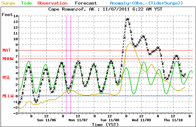
-
Alaska/Western Canada obs and discussion
NIUmetGF replied to patrick7032's topic in Central/Western States
The Anchorage Forecast Office received a record amount of precipitation and snowfall yesterday. .49 liquid and 6.1 inches of new snow. Snow is still falling and we're expecting another 2-4 inches today! Bring it on. This guy needs to do some skiing. -
Alaska/Western Canada obs and discussion
NIUmetGF replied to patrick7032's topic in Central/Western States
-
Alaska/Western Canada obs and discussion
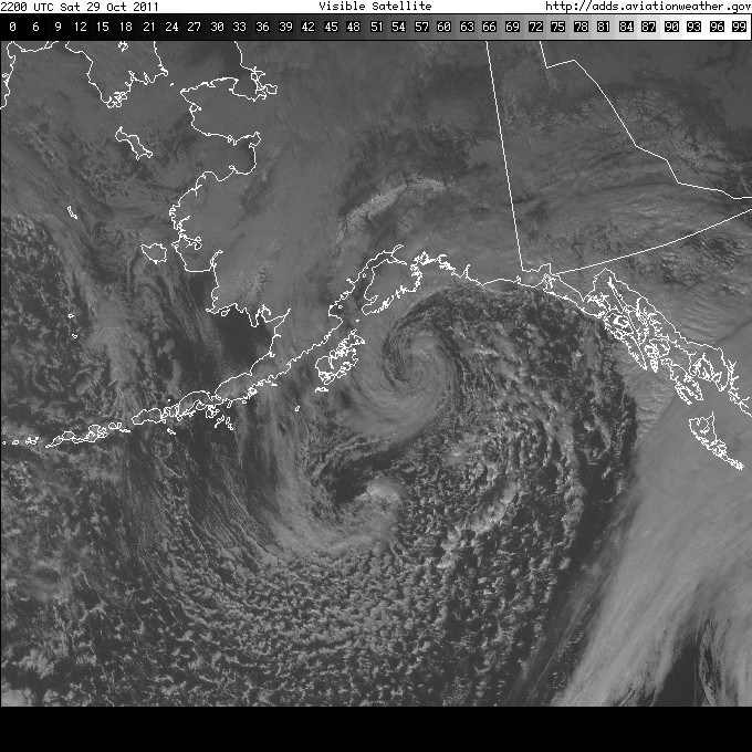
NIUmetGF replied to patrick7032's topic in Central/Western States
http://www.aviationw...t_big&itype=vis Great looking visible loop over the Gulf of Alaska today.