
Kentucky
-
Posts
369 -
Joined
-
Last visited
Content Type
Profiles
Blogs
Forums
American Weather
Media Demo
Store
Gallery
Posts posted by Kentucky
-
-
6 minutes ago, PowellVolz said:
Does Pivitol take away freezing rain and sleet from the snow totals? Is that clown map for snow all snow?
.not sure
-
-
-
7 minutes ago, John1122 said:
I see the interstate is closed in your area or just south of you for black ice.
Looks like north and south of me. Freezing fog/drizzle, it was really coming down.
-
JKL putting snow on the board now 2-4"
That's a change, also the .50 of ice with the snow, sounds well...not ideal for maintaining power.
Winter Weather Advisory
URGENT - WINTER WEATHER MESSAGE
National Weather Service Jackson KY
1050 PM EST Fri Feb 12 2021

KYZ044-050>052-058>060-069-080-084>086-108-111-114-116-131500-
/O.NEW.KJKL.WW.Y.0011.210213T0350Z-210213T1500Z/
/O.CON.KJKL.WS.A.0002.210215T0000Z-210216T1800Z/
Fleming-Montgomery-Bath-Rowan-Estill-Powell-Menifee-Jackson-
Laurel-McCreary-Whitley-Knox-Wolfe-Lee-Owsley-Clay-
Including the cities of Flemingsburg, Camargo, Jeffersonville,
Mount Sterling, Owingsville, Morehead, Irvine, Ravenna,
Clay City, Stanton, Frenchburg, McKee, Annville, London, Stearns,
Whitley City, Corbin, Williamsburg, Barbourville, Campton,
Beattyville, Booneville, and Manchester
1050 PM EST Fri Feb 12 2021

...WINTER WEATHER ADVISORY IN EFFECT UNTIL 10 AM EST SATURDAY...
...WINTER STORM WATCH REMAINS IN EFFECT FROM SUNDAY EVENING
THROUGH TUESDAY AFTERNOON...

* WHAT...For the Winter Weather Advisory, areas of freezing
  drizzle and higher elevation freezing fog will coat untreated
  surfaces with a light glaze of ice. For the Winter Storm Watch,
  heavy mixed precipitation is possible. Total snow accumulations
  of 2 to 4 inches and ice accumulations of up to one half of an
  inch will be possible.

* WHERE...Portions of east central, south central and southeast
  Kentucky.

* WHEN...For the Winter Weather Advisory, until 10 AM EST
  Saturday. For the Winter Storm Watch, from Sunday evening
  through Tuesday afternoon.

* IMPACTS...For the Winter Weather Advisory, untreated sidewalks,
  roads, and bridges could become slick. For the Winter Storm
  Watch, expect power outages and tree damage due to the ice.
  Travel could be impossible. The hazardous conditions could
  impact the morning or evening commute.

PRECAUTIONARY/PREPAREDNESS ACTIONS...

Slow down and use caution while traveling. Prepare for possible
power outages.

Monitor the latest forecasts for updates on this situation.

&&

$$
Special Weather Statement
Special Weather Statement
National Weather Service Jackson KY
516 PM EST Fri Feb 12 2021

KYZ044-050>052-058>060-068-069-079-080-083>088-104-106>120-131000-
Fleming-Montgomery-Bath-Rowan-Estill-Powell-Menifee-Rockcastle-
Jackson-Pulaski-Laurel-Wayne-McCreary-Whitley-Knox-Bell-Harlan-
Elliott-Morgan-Johnson-Wolfe-Magoffin-Floyd-Lee-Breathitt-Knott-
Owsley-Perry-Clay-Leslie-Letcher-Martin-Pike-
Including the cities of Flemingsburg, Camargo, Jeffersonville,
Mount Sterling, Owingsville, Morehead, Irvine, Ravenna,
Clay City, Stanton, Frenchburg, Brodhead, Mount Vernon, McKee,
Annville, Burnside, Somerset, London, Monticello, Stearns,
Whitley City, Corbin, Williamsburg, Barbourville, Middlesboro,
Pineville, Cumberland, Harlan, Sandy Hook, West Liberty,
Paintsville, Campton, Salyersville, Prestonsburg, Wheelwright,
Beattyville, Jackson, Hindman, Pippa Passes, Booneville, Hazard,
Manchester, Hyden, Jenkins, Whitesburg, Inez, Coal Run,
Elkhorn City, Pikeville, and South Williamson
516 PM EST Fri Feb 12 2021

...Freezing Drizzle Is Possible Late Tonight Into Saturday
Night...

Drizzle and freezing drizzle are expected to develop northwestward
out of Tennessee and Virginia tonight and Saturday and effect
portions of eastern and south central Kentucky. Temperatures will
determine whether or not the drizzle freezes as it falls.
Subfreezing readings are expected in most places tonight into
Saturday morning, but are forecast to rise just above freezing in
most places during the day on Saturday, before falling back below
freezing in most places on Saturday night as precipitation tapers
off. Precipitation amounts should be very light, but could be
enough to create slick conditions on untreated surfaces.

$$

HAL
-
 2
2
-
-
3 minutes ago, bluegrassweather71 said:
Shutdown ice storm for our neck of the woods.
Dodged a bullet on the previous ice storm, sadly I don't see us getting that lucky again. And we have like 3 otw...
-
1
-
-
-
-
5 minutes ago, bluegrassweather71 said:
London and Corbin right on the edge of the heaviest ice
I totally expect major accumulation here.
-
Dang..
.thumb.png.85b8474568d2a856cb618f02eecc8f7e.png)
-
1
-
 1
1
-
-
1 hour ago, Blue Moon said:
You know the world's fouled up when Kentucky beats up Tennessee in football and Tennessee beats up Kentucky in basketball.
ha ha, my thoughts exactly
-
2
-
-
For once, the warm nose would be much appreciated.
-
4
-
-
Barnes owns Calipari, Tennessee has won 3 of the last 4 games in Rupp Arena and 6 of the last 9 overall vs Kentucky.
-
1
-
-
I received a gorgeous coating to inch in Corbin, best coating yet.
 Mountains of Eastern Kentucky, slammed again...
-
1
-
-
T 41- D 24
-
12z Nam through 33

-
1
-
-
3 hours ago, John1122 said:
The 06z GFS is insane.


Suppose I'll go ahead and that generator ready today.
-
 1
1
-
-
2 minutes ago, Carvers Gap said:
It gets worse...LOL. Wurbus just turned out the lights on most of the forum.
6 minutes ago, Wurbus said:Icepocalypse. Nearly the whole state gets involved over the run!

-
3
-
-
5 minutes ago, Carvers Gap said:
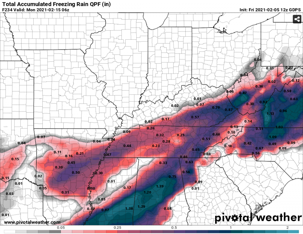
.7" ice accumulations in portions of eastern Kentucky through 153.
.gif.ecae86b6fd8e2afb997996c6686e6718.gif)
-
2
-
1
-
-
-
JKL usually isn't that bullish for NW flow here in Corbin, and for good reason. We shall see how this plays out

-
2
-
-
Snow in London, down to 40 now in Corbin and a dewpoint of 27.
-
43 in Corbin, need this to system to slow down but it's actually speeding up.
-
33 with Flakes finally falling in Corbin, dry air and marginal temps won for most of the afternoon.
-
2
-
.png.415c9b871ca3e4cac6af0018d3004946.png)
.png.b7f71cd2032d0e5d8e9df0de90d1d3aa.png)
.png.d1edac208c526294b5e79f768e87248d.png)


.png.d8242fee41d14fa99bf78c39a91de1fb.png)


2/14- 2/16 Winter Storm and Arctic Cold
in Tennessee Valley
Posted
Per always, on the edge here. Hoping for more snow or sleet, anything to reduce the ice accumulation.