

ragtop50
-
Posts
142 -
Joined
-
Last visited
Content Type
Profiles
Blogs
Forums
American Weather
Media Demo
Store
Gallery
Posts posted by ragtop50
-
-
Dewpoints are inching up. Low humidity been the good and the bad about our heat so far...it does give relief in the shade and when there is a breeze, but it is drying everything up so fast.
-
100 here in Fayetteville yet again. Dewpoints aren't so bad through
-
3 minutes ago, shaggy said:
I'm feeling a little less concerned hear just east of that big batch of heavy rain here. Past experience says this much rain and clouds really hamper severe weather and even though the Windfields are insane lack of sun and a worked over atmosphere always give me pause when it comes to severe weather.
I agree, but a couple of hours of sun could change that quickly. There are breaks in the clouds behind this initial shot of rain.
-
22 minutes ago, ryan1234 said:
I too was wondering that as well. I don't think it will, but I am merely an amateur.
I read somewhere that normally it could, but due to the dynamics and strength of this setup it would have little impact. If the sun comes out later after these storms pass as it did earlier towards Charlotte, I don't think it will matter.
-
I was within a mile of one of the tornadoes back in April of 2011. I could hear it very well (loud roar) and found paperwork in my yard from a house that was 30 miles away. Several homes were wiped off their fondation. Hopefully nothing like that day materializes today. I usually keep up with the weather but that day I was not, and had no clue what was going on. My first clue that something bad was near was the changing wind direction as the storm progressed.
Moral of the story, keep an eye on things today, surprises can pop up fast.
-
7 minutes ago, eyewall said:
Had a bit of a pollen haboob in Chapel Hill/Durham:
Did you take those pictures with a drone?
-
18Z NAM showing some strong cells in central NC Monday night. RAH mentions severe threat with an isolated tornado possible.
-
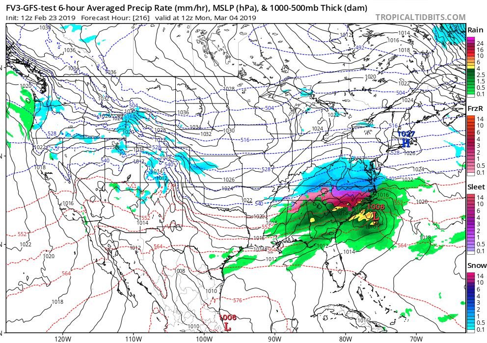
12Z GFS shows some light snow in central/eastern NC on Tuesday now, nothing in this regard on the FV3

-
For what it's worth, the FV3 has this on the 12Z run for March 4th...
-
 1
1
-
-
27 minutes ago, yotaman said:
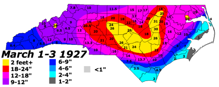
I highly doubt we will ever see a March storm like that ever again.
I imagine the folks back in 1927 said the same thing about their March storm. 24" here in Fayetteville. These epic storms do happen here, just decades apart
-
2
-
-
2 hours ago, Jet Stream Rider said:
They are currently under a tornado warning. Not seeing or hearing much about that locality specifically, but the whole of the area around Wilmington is in dire straits generally. Local reports and storm alerts: https://nwschat.weather.gov/lsr/#AKQ,CAE,CHS,FFC,GSP,ILM,JAX,LWX,HUN,BMX,EYW,MHX,RAH,RLX,RNK,TAE,TBW,MRX,MLB,MFL/201809130400/201809160433/0110
I have been communicating with my brother in Wilmington, and it is BAD in that area. He has never seen flooding this bad in that area, and he has been through many hurricanes down there.
-
 2
2
-
-
11.8" of rain here in northern Cumberland County (Linden), just north of Fayetteville. Several trees down in a low wet area behind my house. No power now for just over 48 hours.
I spoke with my brother in Wilmington and it is BAD down there, he is stuck where he is at home as there is flooding within a half mile of him in either direction.
-
 2
2
-
-
Wind gusts just picked up big time here north of Fayetteville. A few trees down and some tops of trees taken out. Worst winds yet from Florence here
-
Just over 2" of rain here so far just north of Fayetteville, NC (Linden). About right as forecast calls for 2 to 3 inches today, 4"+ tonight, and 4"+ tomorrow.
-
Getting some strong and more frequent gusts here just north of Fayetteville as we get on the north side of the storm. Been without power since 1 a.m.
-
at 8 PM, NHC calling the movement NW at 5 mph
-
1
-
-
3 minutes ago, UpstateSCBud said:
#Florence is getting OWNED by wind shear! Potential it might be an elevated Tropical Storm at landfall... Time to stop shoveling coal into the hype-train; wind, surge and precip will be dangerous, but now significantly lower with this storm: https://t.co/eJ3ufwsY69
The shear is still forecast to subside
-
1
-
-
In the 11 a.m. NHC discussion:
The shortwave trough over the southern Plains seen in water vapor
imagery could end up being a significant factor as it rounds the
narrow ridge over the Tennessee Valley and is expected to erode the
ridge along the U.S. mid-Atlantic coast on days 3-5. At this time,
little change has been made to the NHC track forecast, which remains
very close to the aforementioned consensus aids through 72 hours.
Would this mean a possible north or NW adjustment of the tracks for days 3-5? Just looking for some explanation as to what the result of the trough eroding the ridge would have.
-
1
-
-
10 minutes ago, northwestgastormdawg said:
This sticks out for SC and Georgia
The NHC track has been adjusted southward at
days 4 and 5, and is a little north of the consensus out of respect
for continuity, however, the GFS, ECMWF, and the ECMWF ensemble mean
is south of the NHC track forecast, and additional southward
adjustment may be warranted in future advisories.
That is from the 5 a.m. discussion
-
19 minutes ago, bigshaq00 said:
New to weather, so what could the triangle see from this storm. Could we see hurricane force winds or tropical force winds? Wind?
https://www.nhc.noaa.gov/refresh/graphics_at1+shtml/145000.shtml?hwind120#wcontents
-
7 hours ago, RTPGiants said:
Latest GFS is a little colder and a little slower with precip around the 26th. Still a miss, but closer.
Only had time for a quick glance but now the 6Z looks more suppressed and weaker
-
3 hours ago, Cold Rain said:
I want 24 hours of heavy snow with temps in the teens.
I agree, so back off on the snow shields again!
Dorian
in Southeastern States
Posted
With gusts over 200 mph ! Strongest hurricane on record this far north in the Atlantic