
adk
-
Posts
1,313 -
Joined
-
Last visited
Content Type
Profiles
Blogs
Forums
American Weather
Media Demo
Store
Gallery
Posts posted by adk
-
-
Surprised how warm it has gotten overnight. Up to 37 in BTV and 33 in Mo-Ville. When that cold front pushes through there will be some pretty significant instability.
-
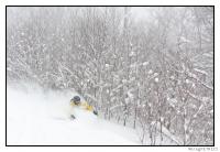
Heavy mid-layer deformation band snows currently rotating through NE ADK and NW VT (Champlain valley). About 2-3" on the ground in BTV with bouts of heavier flakes. heaviest snow is just north it seems on the radar. Colchester on through into Franklin County look to get pasted good. ADK getting crushed.
-
12 hours ago, powderfreak said:
Things very few on here care about...
But looks like a nice 4-6 hour period of favorable upslope conditions along with some additional vorticity tomorrow evening/night across the NW upslope zones. Could see another 2-4" of fluffy snow with that feature by Saturday morning.
I care.
West side weenie event IMO. Blocked to start. Though even fewer care about that.
-
49 minutes ago, timnc910 said:
she has really been getting better organized over the next few hours. alot of models have florence strengthening a little before landfall. with recent ir and visible loops i don't see why it couldn't happen
Yea, the NHC was very clear that this evening she was moving out of a shear environment and over warm waters with favorable conditions to strengthen. Not unheard of for a storm to ramp up a notch just before landfall. I recall Charley doing that just before landfall. Charley jumped from a messy Cat 2 to a very intense organized cat 4 in like three hours - right next to Florida.
-
 2
2
-
-
I think all the focus on the strength at LF misses the point. With a stalled forward speed the amount of rainfall on the Piedmont of NC - where there are actual hills that funnel water - is going to be catastrophic. I was just in Japan where a weak tripical system offshore earlier this summer killed 200+ people from rainfall and flash flooding. If this thing makes 10+ of rain in central NC lots and lots of terrible things will happen. Way overshadowing the impacts on the coast. That's not changing regardless of the max intensity at LF.
NNE Fall Thread
in New England
Posted
About 2.5" wet paste on the ground (and everything) in BTV. Was 0" when I left the house at 5am, and when I returned at 9 there was about 2"...so it snowed pretty well this AM. I'd say 6-10" as you gained elevation. I'm sure that 10" is 12" now.
Feels like NWS should have gone with a WWA for the champlain valley for this one. I know temps are "warm" but this is messy slippery snow that is falling at a good pace. Much snowier than I expected BTV to be.