

Wurbus
-
Posts
489 -
Joined
-
Last visited
Content Type
Profiles
Blogs
Forums
American Weather
Media Demo
Store
Gallery
Posts posted by Wurbus
-
-
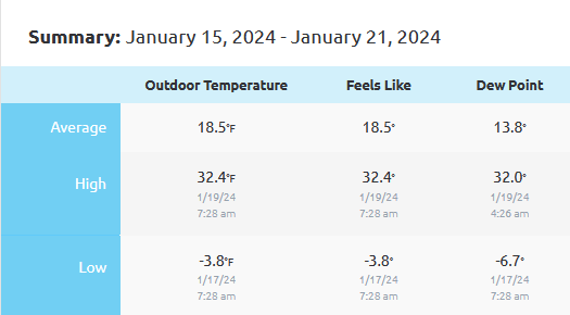
What a week. I still have 4-6" in shaded places a week after the storm. My road is just a sheet of ice and my average outdoor temp was 18.5 degrees for an entire week! Also, the weight of the snow/ice has knocked a lot of my shrubs to the ground. I knocked it off yesterday, but I believe I was too late.
-
 2
2
-
-
I've had flurries since about 9am here in Knoxville. Not really accumulating much, but it is nice to see them flying around outside. Temp has been hovering around 31.
-
2
-
-
I have a question on how temp is reported at the main stations. For example, if the temp reaches 32.6 as the high for the day, do they round up to 33?
-
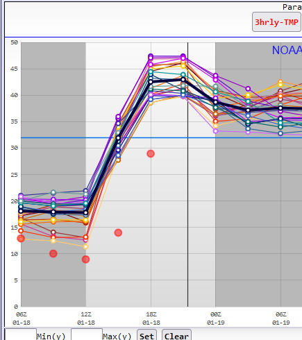
Unsurprisingly, the SREF did not handle the snow pack temps well for Knoxville.
-
 2
2
-
-
I recorded -4 at my house in Knoxville.
-
5
-
-
Someone updated the snow depth on the GFS to show a lot less than what is on the ground. Probably because of the feedback issues. 18z had Knoxville around -15 tonight and 00z is showing 3 tonight.
-
1
-
-
MRX Discussion this afternoon:

As the sun sets Wednesday night, temperatures will quickly fall into
the teens and into the single digits by Thursday morning. Hazardous
driving conditions remain possible across areas that have lingering
moisture/snow on roadways as they will see refreezing.

Heights rise on Thursday ahead of our next system and temperatures
climb back into the mid 30s to low 40s. Precip chances increase
Thursday afternoon into Thursday night areawide. This is in response
to a weak shortwave moving across the area. QPF hasn`t changed too
much since the previous forecast. QPF is still generally around 0.25
inches. Rain is still expected south of I-40, with mixed precip
along and north of I-40 and the Cumberland Plateau, and all snow
across northeast TN, southwest VA, and the east TN mountains. The
predominate precip type still looks like it will be rain/snow but
some light freezing rain can`t be ruled either based on sounding
data. Any freezing rain should be relatively light with ice
accretion averaging a few hundredths of an inch. Precip exits the
central TN valley by late Friday morning but will remain across
northeast TN and southwest VA into Friday evening. This is due to an
upper level trough moving through the Ohio River Valley that brings
additional moisture across the aforementioned areas. Storm total
snow still similar, with 1 to 2 inches possible across the east TN
mountains and southwest VA. Lighter accumulations up to half an inch
possible north of I-40 and along the I-81 corridor. NBM prob data
shows around a 40 to 50% probability of 1" of snow or more across
the east TN mountains and southwest VA.

Another bout of Arctic air moves in Friday night and lasts through
the weekend but no measurable precip is expected during this time.
Overnight lows on Friday and Saturday will be in the single digits
areawide. With low temperatures in the single digits, and breezy
northwest winds, windchill values below zero are likely across all
areas. In these conditions frostbite can begin in as little as 30
minutes with outdoor exposure. By Monday we are back into the low to
mid 40s as high pressure develops to our southeast behind the
departing trough. Our next shot of precip is on Tuesday but all rain
is expected for this round as temps will be in the upper 40s to low
50s during the day.
-
1
-
-
Gotta say the models did well on the "bullseye" area from 3-4 days out they were honking the Knoxville area and most never wavered.
-
3
-
-
11 minutes ago, ShawnEastTN said:
Just going to throw this out there. It's not very common to have deep snowpack over most of Tennessee with an approaching storm. I think many models are really over doing warming ahead the storm and if they aren't over doing warm nose aloft then I really fear a potential ice storm over much of the snow pack area. If we get .25 QPF of freezing rain it will be very bad in normal situations, let alone on trees that have snow on them that is already enveloped in light ice from the switch to freezing rain at the end in my neck of the woods.
GFS could be overdoing the cold, but I noticed it starts with an 12" snow depth in Knoxville while the other models start with 4-6" so I think that could be a major difference in the temp profiles.
-
4
-
-
Nothing on the radar, but getting a nice light snow this morning. Temp is 14 degrees, this cold air is really squeezing all the moisture out of the air that it can.
-
2
-
-
Kinda crazy I have 10 inches of snow, sitting at 23 degrees, and now it has been sleeting/icing for the past 30 mins.
-
1
-
-
Almost looks like some freezing rain now after about 10" snow and temp at 23.
-
1
-
-
Just went outside to shovel some snow for a path for the dogs and measured just over 9" in a few different spots. Also sitting at 23.4 degrees at the house.
-
4
-
-
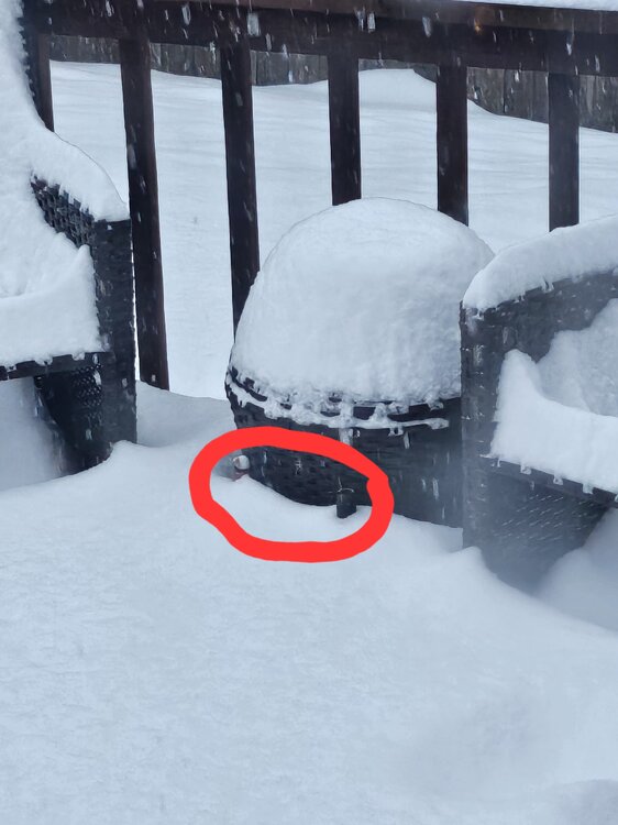
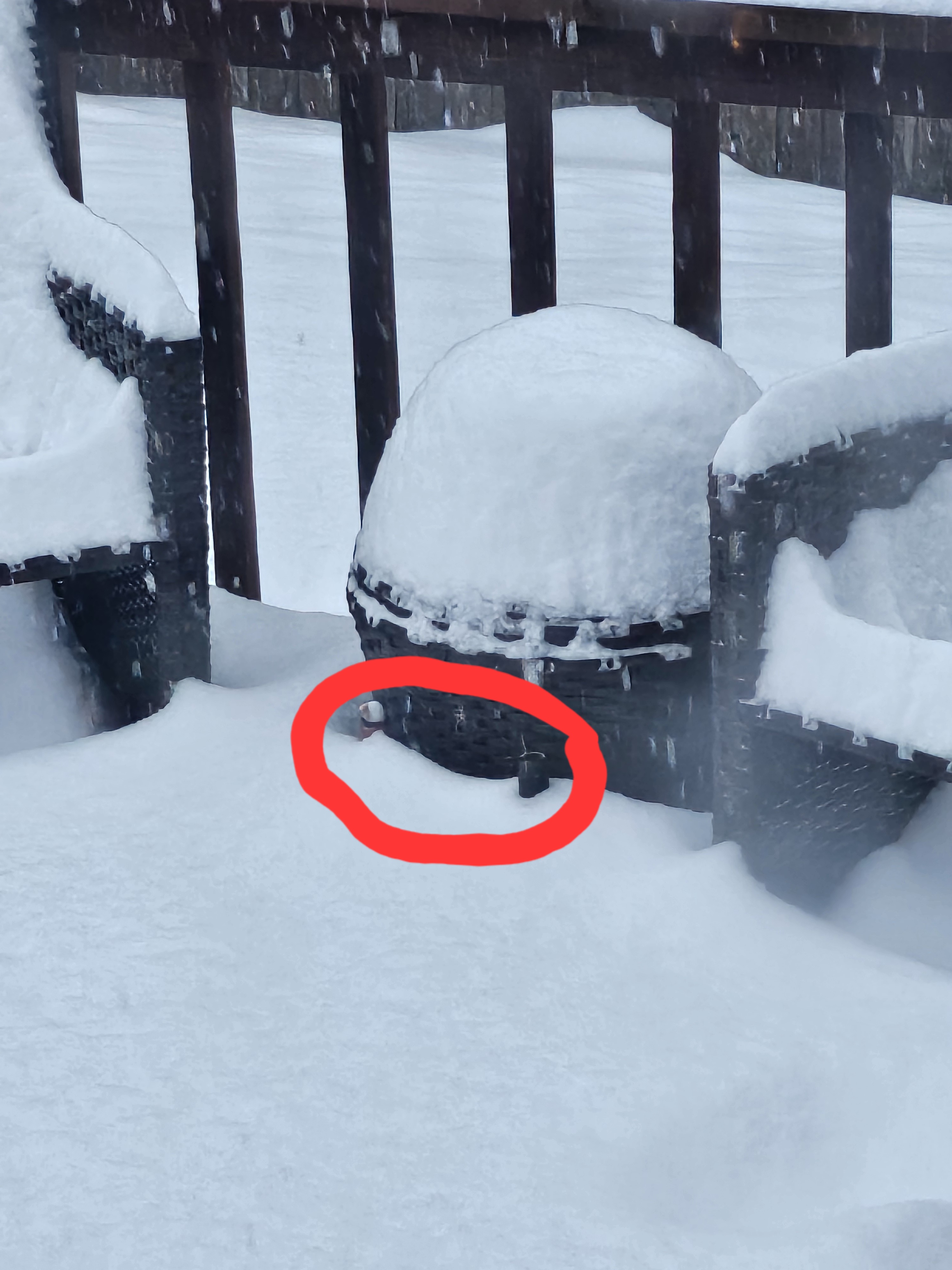
I'm near Karns, and my God it is absolutely ripping. I have to be closing in on a foot. For reference, the tops of these 2 bottles are wine bottles....
-
7
-
-
Looks like the Ukie finally came around. Shows .9 QPF and 9 inches of snow for KNX
-
4
-
-
Looks like almost all the models are showing the heaviest band to setup just south of Knoxville. Through Monroe, Blount, & Sevier counties. Still looks great for most everyone though.
-
2
-
-
I wonder if the Ukie still has some mixing issues. It shows .9 QPF for KNX, but only 4" of snow
-
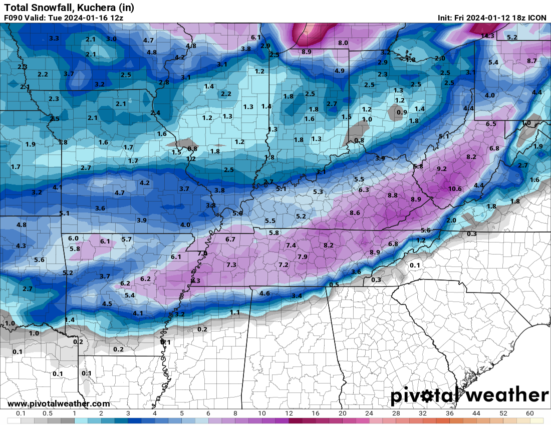
CMC has over half an inch of ice for the 2nd system around the 19th followed by some extremely cold air. Hopefully, that doesn't pan out. That would likely be on top of several inches of snow from the 1st system.
-
2
-
-
GFS totals are going to also be very similar to RGEM & ICON.
-
3 minutes ago, John1122 said:
ICONic
-
1
-
 5
5
-
-
ICON going to look similar to RGEM I believe
-
1
-
-
LONG TERM...
(Saturday night through next Friday)
Issued at 323 PM EST Fri Jan 12 2024

Key Messages:

1. Probability for an accumulating snow Monday into Tuesday is
increasing. Differences in amounts are still significant, however.

2. Very cold temperatures in the wake of the potential snow. Single
digit temperatures and near or subzero wind chill possible Wednesday
morning.

3. Additional wintry system possible late next week, details highly
uncertain.

Discussion:

A rather uneventful start to the period, other than the weather will
be cold with a biting wind. The awkward bit is Sunday will be one of
the warmer days of the week. A strong jet streak will pass to our
north on Monday heading into the Mid-Atlantic, and below that
isentropic lift will draw moisture northeastwards into East
Tennessee and southwest Virginia. Guidance seems pretty consistent
in showing thermal profiles very favorable for snow, with
temperatures throughout the vertical profiles being supportive of an
all snow event. The biggest question continues to be how much QPF we
see. 12z Euro shifted more towards the GFS today, with the GFS still
being aggressive with QPF, and thus snowfall. With us stepping
closer in time, ensemble probabilities of accumulating snowfall are
increasing, a good sign for snow lovers.

Sunrise Monday will probably be dry, with perhaps some virga visible
from the clouds as the lower levels of the atmosphere are modeled to
be quite dry. Caution will be to not let this fool you, as once the
atmosphere can saturate, snow will be able to begin falling to the
surface daytime on Monday. With cold temperatures Sunday night, any
marginal daytime high on Monday should give way to subfreezing
temperatures. Apart from still substantial QPF differences within
the guidance, one of the components will be how long the snow
persists into Tuesday, with the most recent guidance keeping snow
showers into early Tuesday morning.

Past the snow, the big headline will be the frigid temperatures
moving in. Both the Euro and GFS are modeling H85 temperatures below
the 10th percentile from Nashville sounding climatology Wednesday
morning in association with the passage of an upper trough. With the
influence of the snowpack, ultimate low temperatures will be
dependent on snow cover and cloud cover, with potential for single
digit lows. Factoring in any level of a breeze, and wind chills can
be knocked even lower, closer to zero in the valley. We`ll enter a
slight warmup getting back above freezing on Thursday, but an
approaching trough in the long range guidance signals another bout
of both troublesome precipitation and another shot of severe cold.
-
3
-
-
18z NAM seemed slower and setup the main band through west TN, north Nashville, & into Kentucky. Precip doesn't even make it to East TN by the end of the run.
-
Just had some thunder in knox county
-
5
-
Winter 23-24' Wx Observations Thread
in Tennessee Valley
Posted
From MRX:
After yesterday's climate data, Knoxville has confirmed a 7th consecutive day with 4" or more of snow depth. This now breaks the record of 6 consecutive days during February 2-7, 1996 with data for snow depth going back to January of 1910.