

schinz
-
Posts
156 -
Joined
-
Last visited
Content Type
Profiles
Blogs
Forums
American Weather
Media Demo
Store
Gallery
Posts posted by schinz
-
-
Coating to 1"
-
 1
1
-
-
18 minutes ago, Cobalt said:
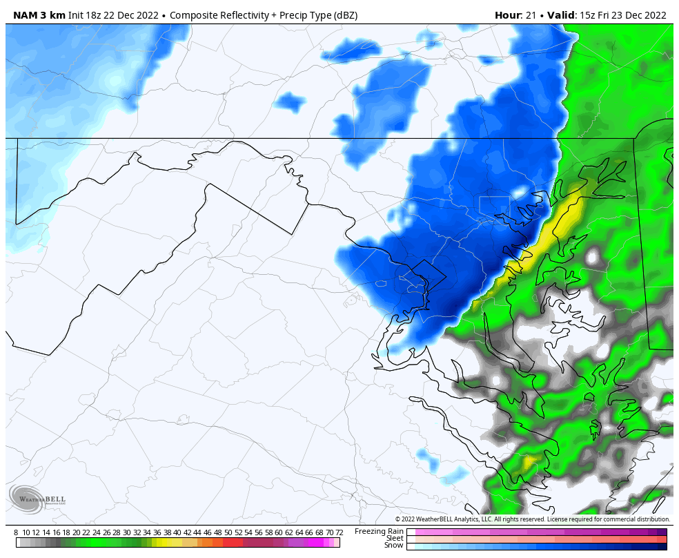
3k NAM does suggest that there might be a brief period of snowfall associated with the front.

This is all that would be needed to create one giant flash freeze mess.
-
 1
1
-
-
6 minutes ago, losetoa6 said:
Just saw what the Euro spit out . Pretty nuts . Doesn't get northern tier above freezing till 11am or so on Friday. Half of that zrain would be a significant event on trees and power lines . All guidance appears onboard for possible significant icing in the favored areas.
Agreed, first it was the GFS was on it's own. Then the high resolutions were thrown out because of range. NOW, the formally warm Euro is fully on board for the Norther tier, as is the Canadian. This could be very bad up here overnight Thursday.
-
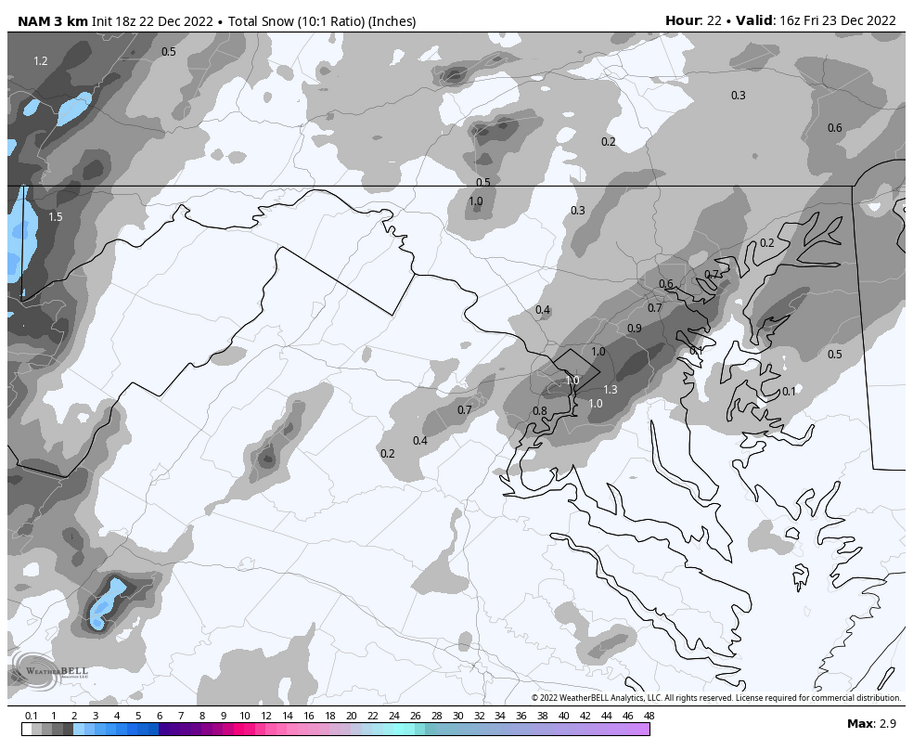
Nam shows significantly colder surface temps than other guidance, including the GFS.
 e for surface temps at 12 z Thursday significantly colder than the other guidance, including the GFS.
-
1
-
-
9 minutes ago, psuhoffman said:

Thanks a lot!!
-
11 hours ago, psuhoffman said:
Sure.

So everything inside the purple line is Parrs Ridge region and generally above 600 feet and does well compared to all around. But the 3 ridges in the zone I circled in blue are around 1000-1100 feet and is a maximum even within the larger maximum. Always gets a little more snow and holds the snow longer. There is often a pretty drastic difference between here and Westminster. Note the little blue dot on the avg snowfall map right about that spot.

Is there a way to overlay that topography map over a road map to actually see roads and addresses that would correspond to the highest heights?
-
59 minutes ago, mappy said:
https://data.imap.maryland.gov/datasets/c77287b935a04b0b9b9e3beba9b5d9b4
really good topography map available through the state of MD. You can pan and zoom to where you wanna lookThanks Mappy
-
1
-
-
3 minutes ago, psuhoffman said:
The best part up here is how well we hold snow. This little high elevation area northeast of Westminster stays cold. I’m regularly 5 degrees colder than Westminster. Often I like to drive around the area after a snow and it’s amazing how much more is on the ground a few days after here v Westminster or other parts of the county.
I am on the SE side of Westminster bear Deer Park and Rt. 32...I am about 850 feet....what is your elevation and can you show some type of a map representation of where that height of the ridge is? Thanks -
16 minutes ago, Roger Smith said:
Not as pessimistic as some here after looking at 12z guidance and current analysis. The GEM and GFS both show quite a strong curved trajectory towards ACY for the coastal and still hint at a stall if not a loop. While this would obviously jackpot e PA, last time I looked there are no states between PA and MD and that jackpot is only 30-50 miles into PA so would expect at least the northern tier of MD counties to approach 20" snowfalls -- the higher this jackpot goes, the better MD does, there would be no physical rule to say that the more snow falls in PA then less would fall in MD. Also the dynamics of this are quite unusual, especially if the CMC is right and they do after all have as good a set of the data input over the current complex upper pattern as any rival model would have.
Looking at 12z analysis, the low in the Midwest is not stacked but has an unusual C-shaped vertical profile from 500 mb in nw IN to surface in se IN (at that time) with 700 and 850 back in IL. That will distort over 24h into the coastal setup and the hook will then be rotated about 90 deg (counter-clockwise) anchored by a 500 mb low over VA, to a surface low bombing east of Delaware. I think with these unusual dynamics there could be more wrap around effect than you might expect with a more standard Miller B.
As to bust calls at this early stage, most of the potential of this storm is Monday-Tuesday, I would not write it off anywhere in the mid-Atlantic and especially not in ne MD or n DE. It could be a 60h storm with an interruption later today, so even if 40 of those hours only produced 0.2" inch snowfalls that's still 8.0" and some of these hours tomorrow into Tuesday will produce considerably more, would expect at least moderate snow in some of the bands extending into MD (S+ obviously possible and will be widely reported in PA and NJ, NYC).
Another consideration is that if a lot of very mild air dams up against a wall of cold south of Long Island while the low is stalling or looping, then some of that will be entrained west across NJ and PA and around the circulation which may create a warm seclusion, which is probably that feature on some models that rotates back across MD in latter stages of the storm.
Anyway, bottom line is this will turn into an intense coastal almost without a direct parallel and do its own thing with memorable results, and you have a front row seat, enjoy.
Nice Post...Thank You!!
-
I think a lot of people would be happy with the CMC....gets the low organizing on the Mid South Carolina Coast at 6 Z Monday
-
Is there a separate topic for anyone outside of Erie county, or is the event confined to Erie County only?
-
4 minutes ago, Eskimo Joe said:
Same. I'm roughly 620' in Reisterstown.
824 here on Parr's Ridge in Westminster!!
-
3
-
-
It appears to me this NAM run would be a pretty warm solution for many of us. Low looks to track North through Eastern Virginia
-
1
-
-
6 minutes ago, BristowWx said:
What are the surface temps?
-
18 minutes ago, BuffaloWeather said:
A parade of cutters and now next weeks storm is too far east.

Right where I want it this far out!!
-
1
-
-
I am sitting up at 1800 Feet on the Chautauqua Ridge at Peek N Peak wondering what my potential is here for the band as it sinks South later today? Amy ideas?
-
2 hours ago, BuffaloWeather said:
Decent band in NE Ohio

Looking at this radar loop, does that band continue into NW PA and SW NY? Is there no radar in that area?
-
1 hour ago, BuffaloWeather said:
That link above is fantastic for people learning about LES.
Yes, thanks so much!!
-
1
-
-
Ok, I apologize, but I am going to ask a stupid question. When considering wind direction for Lake Effect purposes, are we looking at surface wind direction, 700, 850 or 925? Thanks.
-
 1
1
-
-
17 minutes ago, BuffaloWeather said:
As we get closer there are a few things to worry about that weren't there before. Dry air immediately following the passage of the low and shear due to quickly changing wind directions if that shortwave shown in GGEM happens the way it shows. Very early but no longer thinking blockbuster event, but definitely LES Warnings for everyone including northern Erie.
On a side note, thanks so much for your analysis all the time. I very rarely post, but appreciate you and other posters very much. I am going to be at Peek N Peak in Chautaqua County from this evening till Wednesday about noon and am hoping I get stuck there for a day or two more!!! I am looking forward to tracking this the next few days!
-
1
-
1
-
-
2 minutes ago, Thinksnow18 said:
Hell at this far range I'll accept almost 50% @ KBUF
Yes, at this range so much can happen with regards to so many factors that will ultimately determine who gets how much that it seems very safe to follow the generic wording KBUF is in their long range.
"The magnitude and depth of the cold air, available moisture, and position of upper level features all look to be FAVORABLE FOR A SIGNIFICANT LAKE EFFECT SNOW EVENT east of Lakes Erie and Ontario. Obviously at this time range specifics are not possible in terms of location and amounts. Stay tuned."
-
1
-
January 5-6 Thing II: STORM MODE
in Mid Atlantic
Posted