

cutlew
-
Posts
68 -
Joined
-
Last visited
Content Type
Profiles
Blogs
Forums
American Weather
Media Demo
Store
Gallery
Posts posted by cutlew
-
-
I wish there were more MN posters. I can only post so much on the weekdays with job and parenting duties.
NAM has me nervous but I’m chalking it up to NAM doing NAM things. 8-24” is a comfortable range at this juncture.
Did you like the HRRR this afternoon bringing the SLP up into Minnesota
-
 2
2
-
 1
1
-
-
7.6” at MSP.
Largest storm of the year.
All timer forecast bust
Crazy, that band just set up shop and barely moved for about 18 hours. Ended up with 6” imby-
 2
2
-
-
Pure rippage. Airport is reporting 2.4” at 6pm but the NWS office measured 4.2” I’m eyeballing 3-4” imby under heavy snow.
I concur. About to get a little break between bands but just measured 4.5”-
2
-
-
3” of snow this afternoon with 2” in the last 90 minutes
No thunder or fire weather here!
.-
2
-
-
Wow, that’s surprising how low the depth is. Sorry to hear that. I guess even MSP isn’t immune to maintaining a healthy snow cover, even during the heart of winter. The depth has actually decreased by 4” since 1/1, even with a cold January and 4.1” of snowfall during the month (that’s a very low snowfall amount, but you’d think it would have helped at least maintain the 6” depth from 1/1).
There were a few mild days earlier in the month, plus the MSP urban environment probably doesn’t help. Ugh…we need to get past this dry/chinook pattern. Obviously it has been cold recently, but the angle of the cold is all wrong. I used to laugh when Joe Bastardi would say that, but it’s true. This is why you need to build up a snow cover early in the season, to withstand the inevitable dry periods.
Yep we’ve done slightly better not melting outside the city, I’d eyeball 4” imby
. -
That’s very impressive, especially with the significant UHI at MSP. Of course there’s snow cover there and upstream, which helps…and the nights are still fairly long.
What’s your current snow depth, and what was the max depth this season?
Officially 2” otg at MSP, max was 10” back in mid December. We’ve slowly inched our way back down and flirted with bare ground a few times but got the surprise post Christmas storm and some little snows to keep us with some snow.
.-
2
-
-
Since we just eked down to 0 this morning, MSP now forecast to have 10 consecutive calendar days with lows at or below zero by Saturday. And 14 out of 15 to close the month.
Not atypical for MN but (somewhat surprisingly for me when I first saw this chart) the equivalent of 3-4 seasons worth of below zero temps for the southern/eastern parts of the sub.
. -
MSP only dropped to -9 overnight. We should pop above zero today after ~65-70 hours below zero.
Clouds kept to the west of me and we dipped to -18 this morning. One more cold night on tap
. -
-22 at home away from the MSP heat island. Makes the -23 we hit yesterday with all the wind seem even more impressive though.
Good swath of -30s from northern WI across northern MN, looks like a few places just squeaked under -40.
. -
The -9/-21 at MSP gives an average temp of -15, which was the third coldest day in the past 30 years (since Feb 1996).
-
2
-
-
Thermometer showing -20 air temp here, crazy drop this evening over the last 6ish hours from 0 at 4 pm.
. -
This must be what MSP mfs feel like
It is fun watching storms slowly creep into MN while the rest of the board quits winter and Alek trots out the Eurythmics
But also I spent almost a decade in downtown Chicago so I put in my time watching white rain pour down at 33 degrees.
.-
1
-
2
-
-
-10 for a high on Friday and -20 for lows on Friday and Saturday in reach for MN and WI. Would only be the third such high temp and 10th such low temp since 1996 in MSP. Interestingly last year we had a -19 morning with only 1" of snow on the ground. The clippers of the past/upcoming week should help this time around.
Looked through at the Madison WI records which surprised me, it looks to be only their 8th (and possibly 9th) subzero high temperature since 1996 and first time since then with back-to-back days high temp below zero. And there have only been three days with a low of -20 or less in the same period.
Gonna be a while before we surpass the cold and wind chill of 2019 though.
-
Coincidence that packers fans wake up to that view the morning after a bears playoff loss?? I think not
.-
 1
1
-
-
Sun dogs and -9 this morning

.
My dad got a better view over in Wisconsin
.-
3
-
 1
1
-
-
Sun dogs and -9 this morning
.-
3
-
-
The GFS keeps Minneapolis below zero for ~72hrs next weekend. Good stuff.
The Euro is even colder and has us -10 to -25 for about 48h from midnight Friday AM to midnight Sunday AM
. -
Can I go with back to back big dogs if they occurred two days apart? The last week of February 2007. First one was mostly on Sunday at my home in northeast WI but there was so much wind we had Monday as a snow day from school. Then we had Thursday and Friday off with the second storm, so 3 snow days in 1 week. I remember getting about 28” of snow between the two.
Looking back at the WPC storm summaries the first one left anywhere from 8-18” all the way from Milwaukee up past Duluth, and the second one had a swath of 12-24” across most of MN, northern WI, and the UP.
.-
3
-
-
7F with 1mi visibility and snow. What a way to kick off 2026, happy New Year to everyone.
Prettiest of our daily morning snows this week
.-
3
-
-

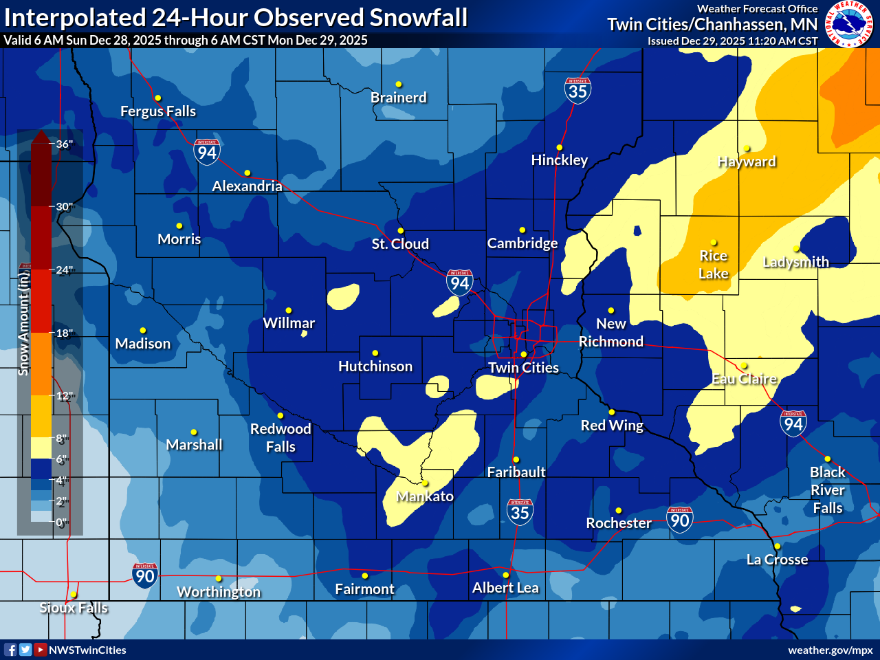
I wonder how they make that map, looks like it cut down from reports including the official sites by about an inch or 2 across the board. I’m guessing the real numbers are somewhere in between with the drifts -
Seems like the blizzard panned out too. I-35 has been closed for hours in southern MN.
-
1
-
-
Agreed, we were about to go into the depths of winter with a few inches of old glacier and no snow prospects. Today (plus a couple weak clippers this week?) will make everything pretty again. And it will help the ski trails.
Noticed the 4 inches is on half an inch of precipitation, even if a little of that was early morning rain not the most efficient snow with it being warm early then windy later
. -
Bears game will be cold but temps in low teens and wind chill around 0? That’s probably an every few years occurrence (if not more frequent) in the NFL between there, Lambeau Field, Arrowhead, etc.
. -
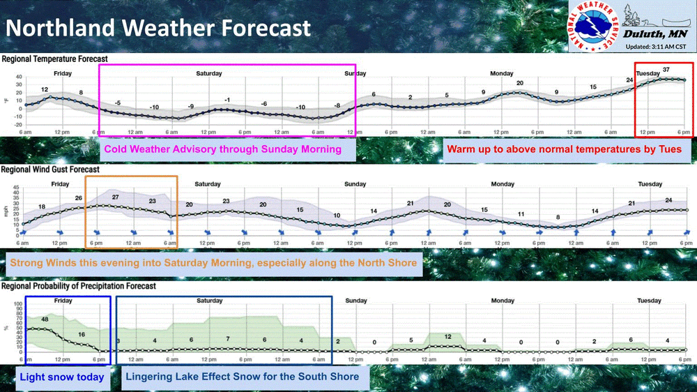
Tonight into tomorrow will be a nasty slap in face. CWA issued. Even Sunday will be brisk.
Curious what your season snow total is now up there?
With the last of the clipper train coming through today I was looking at various places in eastern/central MN over toward Green Bay, and while we’re not breaking records based on MN historically, certainly these two weeks have been a pretty impressive early winter period and better than I can remember for quite a while.
Varies a little by exact location but:
- 12-15 out of 17 days with snow recorded
- Snow totals 15-20+” with most seeing two pretty solid 4-6” events
- Broad swath of snow depth 8-12”
- After this weekend, 7-10 days of min temp at or below 0 from Dec 1st through 14th (outside of MSP proper which stayed above zero a few more times)
.-
2
-
3/15-3/16 Winter Storm
in Lakes/Ohio Valley
Posted
People worried the Apple weather app is too hyperbolic with snow amounts could never appreciate the OG. Glad I got to see this bad boy throw up a 49 spot for me before it’s retired.
.