
NCBlizzard
-
Posts
646 -
Joined
-
Last visited
Content Type
Profiles
Blogs
Forums
American Weather
Media Demo
Store
Gallery
Posts posted by NCBlizzard
-
-
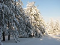
Closing in on 4" here about 4 miles north of RDU. Rates were incredible there for a bit under that last band. Definitely overperformed my expectations!
-
 2
2
-
-
1 minute ago, NCsandhills said:
Beautiful rates in North Hills. That being said I would be surprised if we end up with more than 3". I'll be going for a whiskey-laden walk around me hood in an hour or so to take some pics and take in the smell/feel
Also beautiful here. Just did similar myself taking the dog for a walk. Roads are totally covered. As I was walking back inside, a cop came whizzing by and a minute later I heard sirens, so I figure it's slick out
-
2
-
-
Closing in on 0.25" here about 4 miles N of RDU. Total snow depth (i.e., also including what fell last night with the front) is 0.5". Snowfall rates quickly picking up. Air temp is down to 23.5
-
2
-
-
About 1/4" snow before the changeover here about 3 mi. north of RDU. Freezing rain starting to mix in with the sleet now... was hoping to stay mostly sleet a bit longer
-
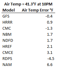
I’m at 31.3 with a wet bulb of 30.2 in South Durham, right at I-40. A solid glaze on elevated surfaces/trees (maybe 0.05”), but sidewalks and roads are just wet. I’m surprised we got this cold here based on trends late last night.
At 9 AM, my station was 2.2°F colder than the NAM and 1.4°F colder than the HRRR projected. Some more light precip moving in now so we’ll see if those trends mean anything at this point. Oddly enough, GFS/RDPS have been the most accurate on temps so far. -
27 minutes ago, Buddy1987 said:
I tend to think however it does run a little too cold in some instances but this atmosphere we have preceding the storm is pretty damn cold. I mean even some of those zr numbers if you cut them in half are still a terrible scenario.
I agree it definitely runs colder, and sometimes by a lot. At the very least, it seems to run 2-4°F too cold on average. RGEM forecast low for tonight here is 15, which is 6 degrees cooler than the NWS forecast and around 10 degrees cooler than all other models except the Canadian. I have a hard time believing we get to 15 here, but we shall see…
-
16 minutes ago, BullCityWx said:
Sometimes things just don’t break your way at all with these storms. If we had more QPF this morning, we would’ve had accumulation easily. I left with a coating of snow and sleet on my car today. Starting with 18z yesterday, there’s been a hole over Durham and Wake Counties on the short range modeling and seemingly they are accurate with that. We don’t have the lift here that they’ve seen west, south and probably east of us will see.
it’s a good thing I considered anything from this event a bonus.
13 minutes ago, BullCityWx said:The triangle has done quite well if you count back the last five years or so.
Yep, been stuck in that hole for a while here in south Durham. I noticed it on the HRRR but hoped it was a fluke. Overall, had a brief rain/snow/sleet mix early this morning 5-6 am, leaving a trace on elevated surfaces. Then a rain/snow mix since 7:30. I didn't have my hopes too high overall though. And you're right about the Triangle being really lucky the past several years. Can't complain much at all given that.
-
Transitioned from a mix to all rain in south Durham (near Southpoint mall for those familiar) an hour or so ago. 34.9 currently, which is about 1-2°F cooler than the NAM/HRRR forecast for 8AM.
-
Rain/snow/sleet mix in South Durham. Temperature has dropped to 36.7.
-
1
-
-
While every model was too warm with dew point/wet bulb temperature here at my place in Durham, still just a cold 33° rain. Below is the forecast dew point error for 9 AM compared against the 32.7°F recorded at my station:
HRRR +0.8°
GFS +1.1°
RGEM +2.2°
NWS NDFD +2.3°
NAM +2.3°
-
I'm near Southpoint Mall and all snow. It's really coming down. My station is reading 34 and wet bulb is almost to 32Still mixing here in SW Durham. Need it to changeover sometime soon. It’s starting to get dark which should help accumulations.
Sent from my SM-G975U using Tapatalk
-
1 minute ago, BullCityWx said:
Dewpoint has been consistently dropping at RDU this morning.
I noticed as well, and the same is happening at my house with the dewpoint dropping at -2.8°/hr now. There seems to be a stretch of locally higher DP through parts of S Orange, S Durham, and W Wake county but hopefully that disappears quickly. NAM dewpoint forecast was about a degree higher at 8AM that what I measured with my station.
-
For my house in S. Durham, the NAM is way warmer than the current air temperature, with GFS/HRRR being the best right now.
-
1
-
-
11 minutes ago, SnowJoMoJo said:
Hi All,
Does anyone know what all factors are included in the "Snow Depth" plots on Pivotal? Is it based on Kuchera or straight 10:1? Consider compaction? Melting due to ground temps? Is this plot generally accurate?
Thanks!
There is a snow melt forecast variable, which I assume accounts for things like ground/air temperature, and that would be incorporated to calculate the snow depth. I also believe it accounts for snow density/compaction. I'm not sure of the overall accuracy. You can see all of the forecast variables here: https://www.nco.ncep.noaa.gov/pmb/products/nam/nam.t00z.bgrdsf00.tm00.shtml
-
Just measured 8.5" as the snow was turning to sleet. The trees are loaded with snow so any freezing rain could mean big problems
-
Eclipsed 6" here but the wind is really whipping it around making measurement tough. The rates right now are the best yet!
-
2 minutes ago, FallsLake said:
The HRRR did show it temporarily shifting back south before the "real" push north. Hopefully that happens. This is some really good accumulating snow.
I'm also impresses with the temp drop. Currently at 29.6.
It has been consistent in showing that which is encouraging. I noticed the 6z NAM also wanted to shift the transition zone back south after briefly pushing it northward.
The rates are amazing right now!
-
Closing in on 4". It's been absolutely pouring snow out there and the wind is ripping. Temp down to 30.2 but CC line is quickly moving north
-
1
-
-
Rates and flake size are definitely on the uptick in Chapel Hill with 1.5" so far. Temp is down to 31.8 and treated roads are now being covered up
-
2 minutes ago, WinstonSalemArlington said:
1255 am... Getting a few reports of light snow near Chapel Hill and Durham. #ncwx
I can confirm. Steady light snow for the past 30-40 minutes. Temp has dropped over 4 degrees since midnight. Currently sitting at 34.5/29.7
-
18 minutes ago, FallsLake said:
Earlier today my NWS grid forecast was set at 5-9" for Sunday (daytime period). It was reduced to 3-5" after lunch time. Now it's been bumped back up to 3-7". Again, I'm wondering what models they're using to create these output. Anybody know?
I think it at least starts with what they call the "National Blend of Models" that is then adjusted by individual offices before the forecast data actually goes into NWS NDFD forecast grids. Here's a a link to some info about that: https://www.weather.gov/mdl/nbm_about and you can also see the text output for the NBM for airports across the US by navigating through this directory: http://nomads.ncep.noaa.gov/pub/data/nccf/com/blend/prod/
NW Trend For the Win! (1/21-1/22 2022 storm) Obs Thread
in Southeastern States
Posted
Ended up with about 3.75” total here 4 miles north of RDU (measured every hour or so on a snowboard). Measuring on the board where I didn’t clear off throughout the storm, the actual snow depth is about 3” due to compaction and wind. Great storm! Beautiful out