

HurricaneTracker
-
Posts
727 -
Joined
-
Last visited
Content Type
Profiles
Blogs
Forums
American Weather
Media Demo
Store
Gallery
Posts posted by HurricaneTracker
-
-
39 minutes ago, NavarreDon said:
Here is the MOB morning disco. Gas meets fire for you guys upstream!
.NEAR TERM /Now Through Saturday night/...A strong upper level
shortwave will move eastward out of the southwest states today.
An associated area of low pressure will move eastward along the
coast this afternoon and evening with a warm front stretched
eastward from the low along the coast. Ahead of the low, a strong
low level jet of 50 to 60 knots is expected to develop and this
will help bring an increase surge of Gulf moisture into the
region by this afternoon. Precipitable water values are forecast
to climb to near 1.9 inches just in advance of the low. The
combination of the deep layer moisture and strong forcing
downstream of the upper shortwave and sfc low will lead to
development of heavy rain across the area primarily during the
afternoon and evening hours. Most areas can expect a general 2 to
4 inches of rain, with locally higher amounts before the rain
exists the area late tonight.

The severe weather potential continues to look very marginal and
confined to areas along the immediate coast where weak instability
may reach inland as the warm front moves north just ahead of the
approaching low pressure system. We cannot completely rule out an
isolated tornado or damaging wind gust due to the strong low level
shear. However, the best potential for rotating storms will remain
over the coastal waters. The primary threat will continue to be the
potential for flash flooding in the watch area. In addition, rip
currents and heavy surf can be expected at the beaches. Minor
coastal flooding will also be possible late this afternoon into
tonight.

There will be a very sharp temperature gradient along the warm front
today with locations north of the warm front staying in the mid/
upper 40s and low 50s. Locations south of the warm front could reach
into the upper 60s to near 70. Breezy conditions will also develop
today, especially in areas south of the warm front along the coast
where the higher momentum air aloft mix down to the surface. A
wind advisory may be required later today. /13
Always nice to confirm upstream obs. Fire hose is primed!
-
 1
1
-
-
6 minutes ago, BretWheatley said:
The 3.71in QPF mean is... wild!
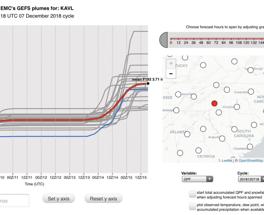
This includes heavy rain next Friday. And that’s a whole other issue. Flooding concerns go up dramatically next week as heavy rain falls on a deep and high liquid water content snowpack.
-
5 minutes ago, BretWheatley said:
Honestly was just eyeing it based on the upright coming through. Spoke too soon!
Not necessarily too soon. It can happen upright if it lines up just right
-
1
-
-
11 minutes ago, BretWheatley said:
New 3kNAM seems like there’s a chance of some thundersnow...
How are you determining this? What parameters/fields? Thunder snow is not usually done by upright convection (summer storms) but rather by slant wise convection which is hard to get model output on.
-
3 minutes ago, wncsnow said:
That's a crazy run for the escarpment.. Over 2 feet in many places..
Lines up perfectly with Euro and FV3. All models in excellent agreement.
-
00Z NAM looks great for AVL to Boone! Much better wedge this run and substantial liquid QPF over 2.25". Mixing with sleet, if it happens, would be mid morning Sunday near tail end of the event....based on soundings analysis and not some silly colored algorithm
-
Just now, AsheCounty48 said:
I assume that's for Asheville?
Yea. Boone liquid mean is 2.27" with 15.8" of snow
-
New 21Z SREF is in. Wet! Mean up to 2.63" with 8 members over 3.00" of liquid. Snowfall mean 11.45". Few members over 30" and under 2". Lol. My bet is 00Z NAM comes in wetter
-
1
-
-
11 minutes ago, Moonhowl said:
The one nagging doubt I have is the gulf hasn't had much time for a winter cool down; I just can't help but think there is a warm nose sneaking up behind me despite the CAD in front of me.
Gulf temperatures have zero impact on our storm. If anything, warmer temperatures support more evaporation and thus more added water vapor / moisture availability.
-
2
-
-
8 minutes ago, Buckethead said:
I'm starting to wonder if convective activity on the gulf coast will affect the moisture transport.
We do need to watch this. But seems that given the moisture transport mechanism off of the Gulf and Atlantic, perhaps this won't be too big an issue.
-
2
-
-
2 minutes ago, BretWheatley said:
HRRR looks odd...
Nah. Looks fine to me. All systems go.
-
2
-
 1
1
-
-
3 minutes ago, Cheeznado said:
Pinch me, I will be headed to AVL tomorrow very early- if they get over 18" (and that seems to be a growing consensus) it will be the biggest snow storm ever there- also I have never personally seen that much snow in one storm.
Looking super promising at the moment. 12Z NAM soundings are surprisingly supportive of all snow (no mixing at all during the event). So then snowfall will be determined by ratios and compaction.
-
4
-
-
NAM is HUGE!!!! ALL SNOW SOUNDINGS for just about the entire event. Closing in on 20-25" across Henderson, Transylvania, Buncombe, and McDowell counties.
-
4
-
-
-
1 minute ago, franklin NCwx said:
Its warmer out this way than the fvs and euro.
This is probably correct. Intense warm nose by deep southerly fetch of moisture riding north on 50kt LLJ and you guys are almost always tucked away from the wedge.
-
1 minute ago, Tyler Penland said:
NAM much wetter.
And substantially colder. Now aligns perfectly with Euro, FV3, and CMC.
What worries me greatly is 55 knot winds at 850mb Sunday morning in the mountains. Exceptionally dangerous situation may be unfolding!
-
2
-
-
3 minutes ago, BlueRidgeFolklore said:
Listening to Jason's live video right now, you could tell he was caught off guard earlier by GSP and it made him a little uneasy. Now he's back to his guns and he's very confident. Feels only mixing will be an issue in SW mtns. Calling for huge totals in central and northern mtns.
00Z NAM trending his direction. Starts precip MUCH earlier (mid morning Saturday) and thus wedges us in much sooner.
-
4
-
-
SREF plumes for AVL have really skyrocketed today. The scale now goes to 40"! Three members over 30". Three members near zero. 00Z NAM should be telling.
-
2
-
-
1 minute ago, BlueRidgeFolklore said:
So do we toss GSP? Lol.
Ha ha ha. For now.....yes
-
 1
1
-
-
2 minutes ago, Tyler Penland said:
Holy hell the 18z fv3 is juiced up.

Finally looks like Euro
-
4
-
-
Good evening everyone. I wanted to take a moment and give y’all an update in light of the disastrous communications issue that is unfolding before our eyes.
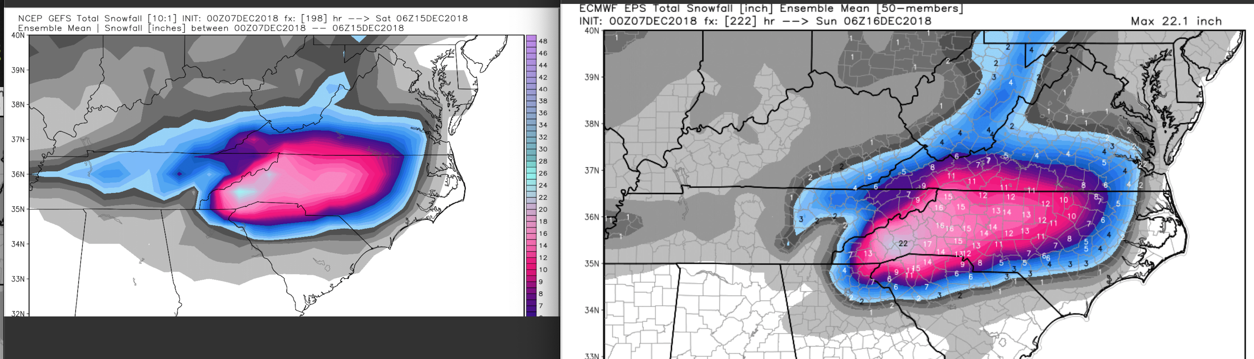
1. Overall things have NOT changed that much since this time yesterday. Euro came in with a swath of 20”+ from KAVL to KTNB and consistent liquid equivalents around 2.50”. Duly noted is that the Euro was NOT mentioned in the afternoon discussion by GSP. It has been absolutely rock solid on this storm system since last Saturday! To boot, we added the CMC model today with a lot of liquid equivalent, too. And now the 18Z FV3 (which we should all be looking at since it IS our future!), comes in with at least 2.00” of liquid (minimum QPF in Bristol, TN but that is expected given the setup).
2. 12Z NAM was a dumpster fire and has since corrected itself at 18Z (more corrections coming too, I suspect). 12Z GFS was a dumpster fire (just ridiculously low QPF) and p-type issues abound. Yet, this is the model of choice today by GSP. Oh but wait there’s more! 18Z GFS self-corrected and came in with more QPF and colder wedging solution. You want to hang your hat on the GFS? Better be ready to make more changes to the snowfall forecast as the GFS shifts.
3. Let’s talk warm nose. Does it exist? YES. Someone in the main thread said NE Georgia was out of the snow. I agree. This is climatology. Even parts of the favored escarpment areas will see sleet for a time being Sunday morning. What is confusing the models is the isothermal layer in the soundings. My eye sees the isothermal layer as a deep layer of snow, since dendrites will be falling into this isothermal layer. ALL MODELS say that even at 850mb temperature of 0.1 deg F this melts the flakes. I just completely and utterly disagree. In all my years of forecasting, deep isothermal layers that hover on the 0 deg isotherm (and are below freezing either side of this layer) tend to run as all snow. Watch for this in the next 24 hours.
4. Do we need to cut down snow amounts? Maybe. But don’t forget we are using a 7:1 ratio anyway to start with (see my post from yesterday). So instead of 2.50” of liquid coming out to 17.5” of cement, maybe we go 2.00” of liquid and 14” of snow. I’m currently most comfortable going with a range of 8-12” for KAVL and the eastern escarpment. Boone will see slightly more sleet because they are actually *too high* in elevation and above the wedge into the warm nose. So instead of 17” there, I think 8-12” also applies to them.
Hang in there folks. Watch the 00Z trends. Can’t ignore the intense dynamics and the fire hose that is our deep tropical moisture connection!
-
5
-
3
-
-
Just now, BretWheatley said:
WSW up - WTF at the below... 1-8 inches. I need a beer, ASAP.
* WHAT...Heavy mixed precipitation possible. Total snow and sleet
  accumulations of 1 to 8 inches are possible. Ice accumulations
  up to two tenths of an inch are also possible.
and they gave no nod to the FV3 (which has liquid to > 2").
-
1
-
-
3 minutes ago, buncombe said:
It looks like they are expecting all the early precipitation fall as either rain or sleet in the Asheville area, thus drastically cutting totals. And they say they didn't even use the NAM for this forecast, so this must be based off GFS and Euro?
They based it off of the lower QPF values from the GFS. Didn't even look at or mention the Euro.
-
1
-
-
22 minutes ago, BretWheatley said:
SREF Plumes mean for KAVL is up to 11.7 - https://www.spc.noaa.gov/exper/sref/srefplumes/
This is a big deal given the horrid 12Z NAM run we saw. Just verifies to me that the 12Z run was junk.
EDIT: also suggests the NAM will correct itself at 18Z
-
3
-
1
-
2018/2019 Mountains and Foothills Fall/Winter Thread
in Southeastern States
Posted
Heads up! High pressure centered in Illinois is 1039.2mb! This is the strongest it has been and bests all model expectations from the last several runs. Something to watch as the day unfolds.
Edit - note the temperatures BELOW ZERO in Wisconsin. Teens in central Illinois. GFS was too warm by 10-15 degrees in this area of Wisconsin, but NAM not too far off. NAM and GFS about 1 mb too low on the strength of the high though.