

MidwestChaser
-
Posts
962 -
Joined
-
Last visited
Content Type
Profiles
Blogs
Forums
American Weather
Media Demo
Store
Gallery
Posts posted by MidwestChaser
-
-
3 minutes ago, RyanDe680 said:
on that NAM run parts of Lake and nearly all of McHenry County get goose egged.
I get a whopping 1-2 in SW Dupage.
-
Central IL can have this one; been locked into a sling since December with a fractured shoulder and can’t get surgery until April.
-
-
Party time for the Indy crew finally?
-
 2
2
-
-
37 minutes ago, Chicago WX said:
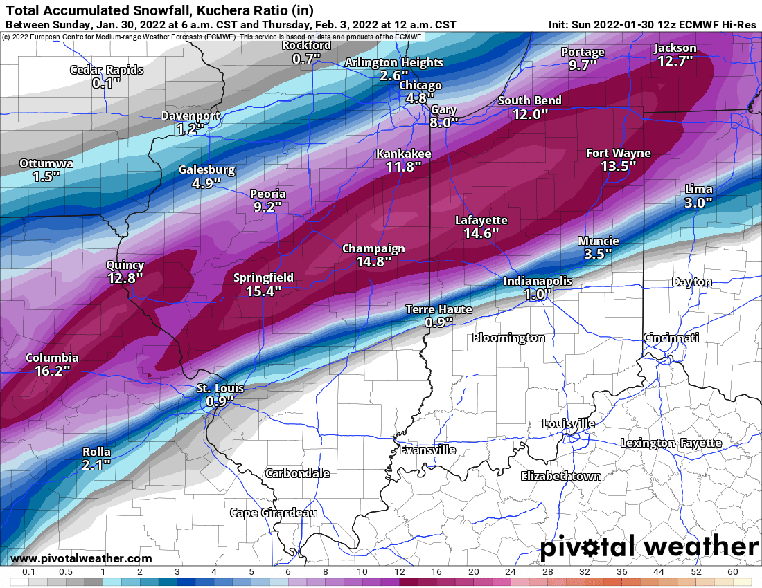
27.4". Why not?
-
1
-
-
WSW already out for part of Iowa.
-
This guy's a troll.
-
 1
1
-
 1
1
-
-
1 minute ago, WVU said:
Not at all. I deal with facts is all. If I do not know something I will say so. The Mayfield survey was very thorough and was reviewed by an outside meteorologist/engineer with 39 years of experience. That is a fact.
You can disagree all you want about the EF rating of that tornado or the EF ratings period. Unless you have experience surveying tornadoes or personally know the folks doing the surveys you are not being fair to them.

-
1 minute ago, WVU said:
I do know for a fact that the Mayfield survey was very thorough. They even had their survey reviewed by an acknowledged expert who I messaged. The person with 39 years of experience.
Did you create an account here just to argue?
-
1
-
-
17 minutes ago, WVU said:
Have any extra popcorn? You might need it!
You seem pretty mad tonight.
-
5 minutes ago, WVU said:
That wasn't the case nor is it nonsense. The NWS office did the survey as required. The NWS office contacted an engineer/meteorologist with nearly four decades of experience to review the survey. I asked him why it wasn't an EF5 and that was what he told me. You're an meteorologist based on your profile. However I doubt you have done much in the way of tornado surveying. This person is an expert in this field having done it for so long. The NWS has the final say of the rating by law.

-
Look at it this way; do we really want potential Ohio State fans getting everything messy with Skyline Chili? It’s better to keep them contained.
-
3
-
-
-
7 minutes ago, Malacka11 said:
Finals calls in a day or two? Or now if you're Alek?
Way too early for that; remember February 2020?
-
1
-
-

-
1
-
2
-
2
-
-
6 minutes ago, brianc33710 said:
Admttedly Its Wikipedia, but heres a report from the 27 April 2011 Superoutbreak that looks directly taken from the NWS damage surveys. So this is what 10.5 years ago what each significant tornado was rated & why. https://en.wikipedia.org/wiki/2011_Super_Outbreak#Notable_tornadoes
Looks like several of the EF-5s then were classified based on extreme ground scouring. Wasn't that also seen here?
-
2
-
-
I would be very surprised if this isn't EF-5. This doesn't look like previous instances of houses swept away yet trees are still there; this is complete destruction.
-
HE SEVERE WEATHER THREAT FOR TORNADO WATCH 552, 554 CONTINUES.

SUMMARY...A STRONG TO POTENTIALLY VIOLENT TORNADO IS ONGOING AND
EXPECTED TO CONTINUE FOR AT LEAST ANOTHER HOUR.

DISCUSSION...A STRONG SUPERCELL WITH A HISTORY OF A LONG-TRACK
TORNADO WITH INTENSE TO POTENTIALLY VIOLENT DAMAGE HAS RECENTLY
INTENSIFIED ONCE AGAIN ACROSS SOUTHWEST KENTUCKY. LATEST RADAR AND
ENVIRONMENTAL ANALYSIS GIVE HIGH CONFIDENCE THAT AN INTENSE TO
POTENTIALLY VIOLENT TORNADO HAS OCCURRED ACROSS SOUTHWEST KENTUCKY.
THE RADAR PRESENTATION OF THIS STORM CONTINUES TO BE EXTREMELY
FAVORABLE FOR CONTINUED INTENSE, LONG-LIVED TORNADOES. NEARBY
CONVECTION HAS MOSTLY DISSIPATED WHICH MAY ALLOW A MORE STEADY-STATE
TO CONTINUE AS IT MOVES NORTHEAST. THE DOWNSTREAM ENVIRONMENT
REMAINS VERY FAVORABLE WITH UPPER 60S TO LOW 70S DEWPOINTS AND
BACKED SURFACE WINDS WITH STP AROUND 5 TO 6. EVENTUALLY, EXPECT
STORM ACTIVITY TO THE WEST TO CATCH THIS SUPERCELL, BUT UNTIL THAT
HAPPENS, CONTINUED STRONG TO POTENTIALLY VIOLENT TORNADIC DAMAGE IS
EXPECTED TO CONTINUE ALONG ITS PATH.
-
New Day 2 mentions possible upgrade to Moderate.
-
1
-
-
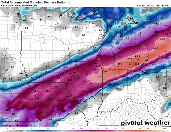
Posting 200+ hour runs.

-
3
-
-
It might well come to nothing if we don't have a good EML. The trend toward a neutral/negative tilt with a "pinched" trough (i.e., one farther south with time) is not encouraging, as that would discourage a good EML from emanating over the warm sector. Anyway, we don't need more HP cells causing havoc for both communities and chasers.

After what you pulled last weekend, read more and post less. It's telling how once you were proven wrong, you ran away for 2 days.
-
Allow me to describe the 00z GFS mid/long range with the appropriate emoticons:


Thundersnow12 and I hit the road with COD next Friday.

-
This is the closest I could get to the Chicago heat wave in 1995. I remember seeing a graphic on LOT's site some year's back of LI's near -25.

-
http://weather.cod.edu/satrad/index.php
Check out the 48 hour loops.

Feb 1-3rd GHD III Part 2
in Lakes/Ohio Valley
Posted
Remember kids, all weather models are terrible unless they show what outcome you want.