Z-Cast
-
Posts
200 -
Joined
-
Last visited
Content Type
Profiles
Blogs
Forums
American Weather
Media Demo
Store
Gallery
Posts posted by Z-Cast
-
-
18z FV-3 Low coming in a little further N...
-
 1
1
-
-
Appears to be an earlier onset as well. Trend is our friend...
-
That precip shield is looking healthy at HR 60..
-
Just now, nj2va said:
That is one juiced up STJ. Parts of TX/LA pushing 9” of rain
Houston is going to be underwater.
-
6 minutes ago, Yeoman said:
NAM much further north with the precip into Tennessee at 36 compared to 18z
Precip shield looks roughly the same however at HR 39 compared to 18z. L appears to be a tad quicker.
-
8 minutes ago, 87storms said:
i feel like dc is in a prime spot for this based off of where the 500 low is heading.
Per HRRR Northern Neck to Eastern MD is going to get pummeled.
-
6 minutes ago, Windspeed said:
00z ECMWF is coming west and closer to OBX. That in itself is important. Maria comes close enough to create some excitement. But the pattern looks less than favorable for an intense system. Going on track alone, the threat is increased. But to be optimistic, the hurricane itself is significantly weaker in that environment. We have to take the shift west seriously however.
Also, that trof continues to slow dramatically each 00z run.
-
Just read about massive flooding in Levittown in Toa Alta. Residents stuck on roofs as water rises. Sickening.
-
NHC OFCL track more N of verification.

-
 1
1
-
-
1 minute ago, NJwx85 said:
It still gets kicked out by the trough in the end.
Trough a lot slower through 192. Will have to see if that is a trend.
-
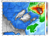
Rain total estimates thus far.

-
6 minutes ago, Mountain_Patch said:
I'm starting to come to agreement with 40/70 on his contrarian nature. None of these islands minus Barbuda have been completely decimated. Fact is at this current heading, it's going to interact with the mountains prior to hitting San Juan. The infrastructure will be damaged, but it isn't coming in from the northern part of the Island it's coming in from the South Eastern. It will be bad, and people will die, but this is a compact hurricane that doesn't have the size, or the punch Irma did at her maximum. The damage will be similar to the 7.1 in Mexico, and it will suck. However, this isn't going to be Biblical. We shouldn't let our imaginations run so wild with these storms. People who read the forums get the concept that it's going to be like Tuscaloosa, Moore, Joplin, but it's just not.
Also; If you'd do a little googling you'd see HAM radio operators are still in communication. Just because some services are out doesn't mean all are.
http://www.arrl.org/news/radio-amateur-on-st-lucia-relays-reports-of-hurricane-devastation-on-dominicaTerrible post.
So many assumptions made, please stop.
-
13
-
-
5 minutes ago, cmasty1978 said:
thanks, ive have been following TC's for decades.
but please feel free to tell us every time it fluctuates. super useful.
At least she's posting relevant obs data, and not slinging around opinion on said data. Get back on track with obs.
Air Force recon aircraft is departing from Curaçao to find out how strong Maria has become. We'll know between 7 and 8pm EST.
-
4
-
-
Just now, DopplerWx said:
euro showing jose strengthening over the next 24hrs, not sure about that given the current presentation.
Models have done a pretty horrid job overall with Jose.
-
1
-
January 12-13th Cold Smoke Obs and Nowcast
in Mid Atlantic
Posted
Don't interrupt SnowCoke, he's outside with his blowdryer heating up his measuring spot.
28F and dropping here in Warrenton.