WxMatt21
-
Posts
114 -
Joined
-
Last visited
Content Type
Profiles
Blogs
Forums
American Weather
Media Demo
Store
Gallery
Posts posted by WxMatt21
-
-
3 hours ago, NTXYankee said:
lol looks like we’ll have to continue talking about it because this threat went poof. Maybe by the end of the season with this crap pattern we’ll get to page three in this thread.

I personally don't understand the point of putting out a risk map more than three days out. This is, what, the third or fourth time something like this has happened?
In any event, with a somewhat cool and dry pattern shaping up for much of the subforum, it may be a while before a more substantial threat emerges!
-
 2
2
-
-
3 hours ago, NegativeEPO said:
well it looks like you can kiss a warm April goodbye, might be even worse than last year, I think. In fact, I think this entire year might be the one of the coldest on record by a long shot for the eastern half of the country. Wouldn't surprise me if we see some snow in June. It's one of the consequences of climate change unfortunately. Years like 2012 may never be seen in the midwest/east ever again.
Is this the same person that threatened to scream at every person in the state of Illinois because it didn't snow enough this past winter? Either way, I am impressed by the sheer dedication to hyperbole and drama in this thread!
-
 1
1
-
-
On 2/4/2019 at 1:26 PM, beavis1729 said:
This is a complete disgrace.
My kids build snow forts last week and go sledding and ice skating, when we finally get some wintry weather in this joke of a season...and then it’s all gone. 15” of snow cover melted in 2 days. It would be bad enough to lose 5” in 2 days during DJF; even that should never happen. Last week, it looked like the ponds and lakes may actually freeze solid for a long time, until mid March like it should...but now they are melting out already. How can this happen? It was -27 four days ago, and the lakes are melting now????? It’s completely unacceptable. There is no other way to describe it.
When a pattern relaxes or turns “unfavorable”, it should mean a modest 5-10” of snowfall over a couple week period, and mild temps in the 20s. Then, the good/decent 2 week periods should be 15”+ of snow with cold temps, like what happened in the second half of January. It should never get above freezing in DJF. Doesn’t need to be below zero consistently like last week...but winter is a season, not a “series of events”. I am so sick of people’s expectations being so low. We should not have to hope for the EPO, AO, ENSO, etc. to behave a certain way in order to have wintry weather. We have had 3 weeks of winter out of 9 DJF weeks this season so far. That is not winter. And parts of the Chicago area have only had 2 weeks, as they missed out on the November storm. Are there ever any summers where only 2 weeks out of 9 feel like summer???? In most summers (June 10th to Sep 10th), 90% of the days feel like summer. In summer, people don’t worry about needing the right pattern or indices to get summer weather. In July and August, it’s summerlike because the calendar says it’s summer. Very simple!!!
It’s always something. In early December, when you would think it’s time to get excited about winter due to the short days, normal highs are still around 40. That is not winter...so what is the point of getting excited about the short days?? Then in late January, the daylight is getting noticeably longer. In February, the sun angle increases. Of course it doesn’t mean that snow can’t stick...but it has a big impact on snow retention. In February, there is noticeable snow melt on sunny days with highs in the 20s. That shouldn’t happen. So then we are left with 6 weeks of what you would think is decent, stable winter. But even during this time, highs in the 30s or warmer are fairly common...which is ridiculous. Good luck retaining snow with those temps. Even our coldest time of year isn’t winter!!!
But nobody gives a crap. How can people just accept this? How can people keep pretending that we have winter? Sure, we have “occasional wintry weather”, but not winter. There is a huge difference.
What is the point of having any interest in winter. It is a false hope...every single ****** year. I am so so so angry I could scream at everyone in the entire state. It is an abomination. Good bye all. I cannot take this anymore. May be back next winter, but probably not. Not worth the anxiety and trouble. Best wishes to all of you. This is nothing personal against anyone. I just can’t take the inner anger and sadness anymore. And yes, I would like to move...but I need to support my family here in this ******* for at least 10 more years. Trying to save as much as possible to leave sooner.
Easily one of the top 5 weenie meltdowns of all time.
I mean, I love winter and snow, but DAMN
-
3
-
3
-
-
15 minutes ago, IWXwx said:
Dang, we may need to start a LES thread already:
THEREAFTER SOME BRIEF RELAXATION EXPECTED IN MEAN TROUGHING THROUGH
ERN CANADA BEFORE BUCKLING STRONGLY LATE PERIOD AS A FORMIDABLE
SYSTEM DEVELOPS INVOF JAMES BAY. THIS IN TURN LOOKS TO SHUNT AN EVEN
COLDER AIRMASS SOUTH ACROSS THE LAKES SIGNALING THE FIRST LAKE
EFFECT DERIVED PRECIP EVENT OF THE SEASON LATE SAT INTO SUN.
Yup. Actually included flakes in my 7 day Sat night/Sun AM because the signal has been there for a while. Wouldn't be surprised to see flakes well inland at times!
-
2
-
-
28 minutes ago, iluvsnow said:
I know we have all been waiting for it with fervor and anticipation....the always detailed....always in depth....always provocative......Accuweather winter forecast. Again....chock full of metrics enabling precise verification.....

"Cold shots"
"Cold & Mild Periods"
I actually let out an audible chuckle!
-
2 hours ago, Hoosier said:
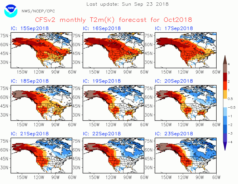
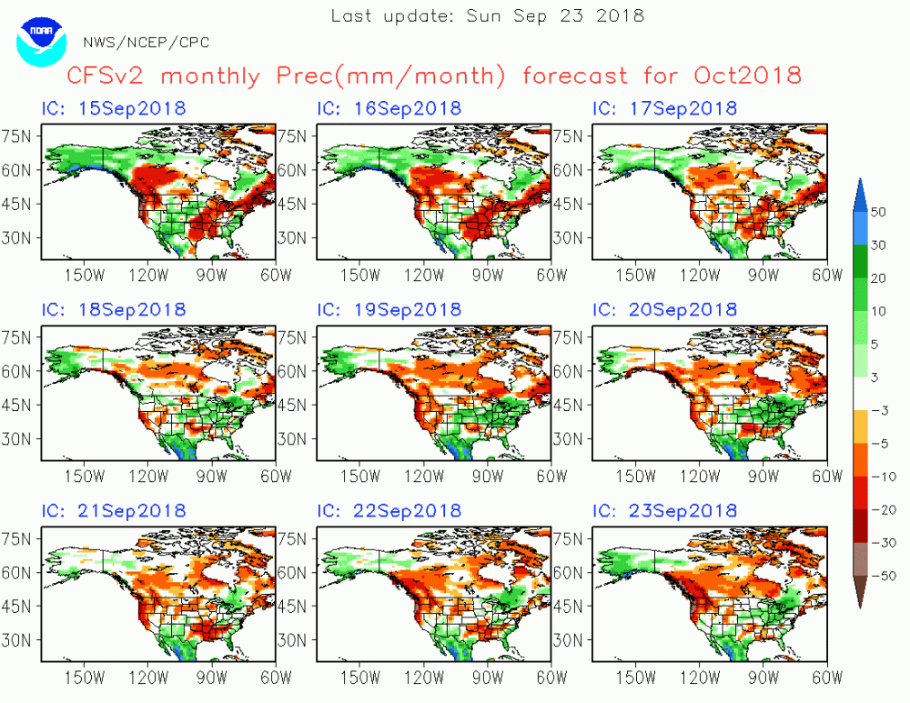
After the warm runs earlier this month and then a cooler trend, the latest CFS runs are going with a north/south gradient look.

Hey, I'll take this versus an all-out North American blowtorch. We need that cold air to continue pooling up to our north so that when it matters, it can spill east.
-
1
-
-
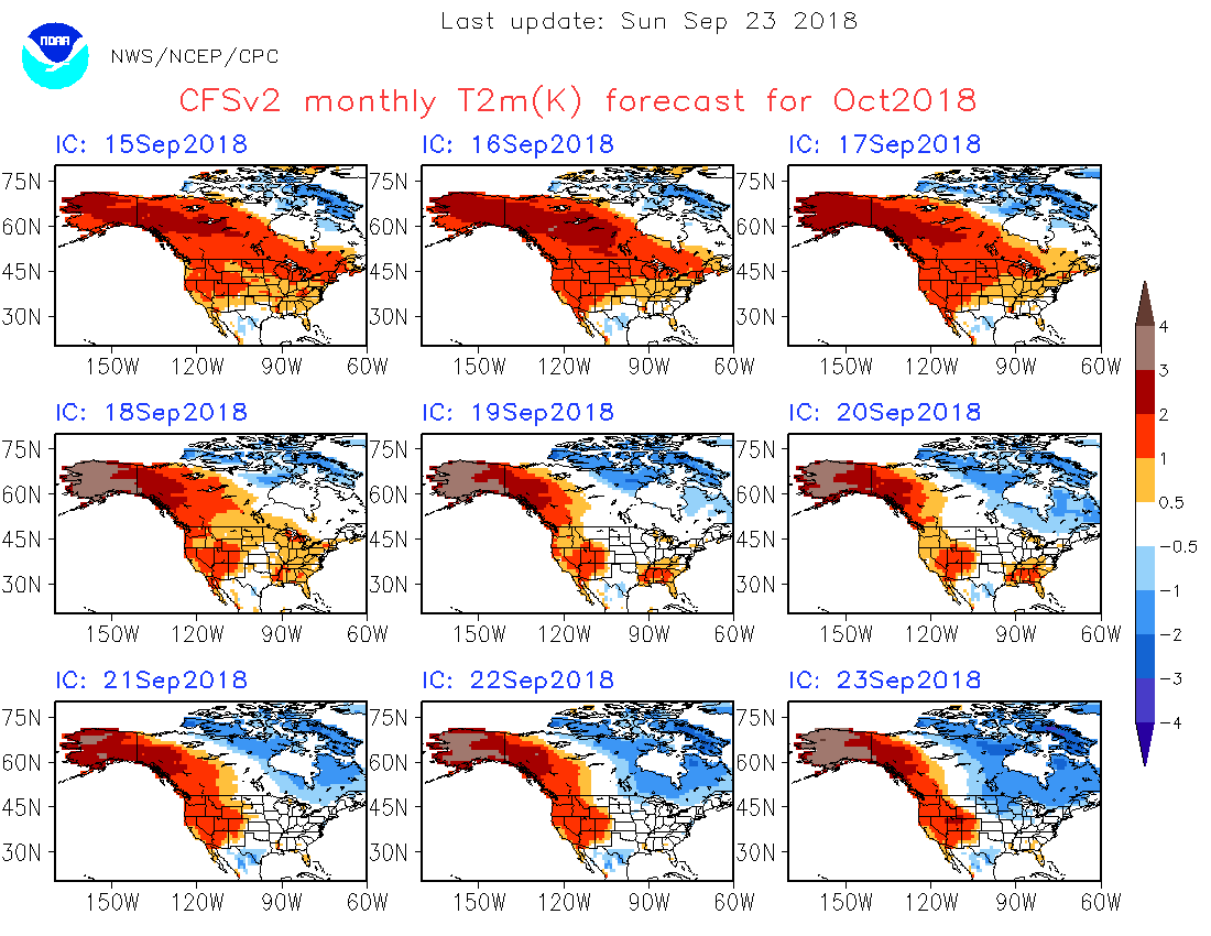
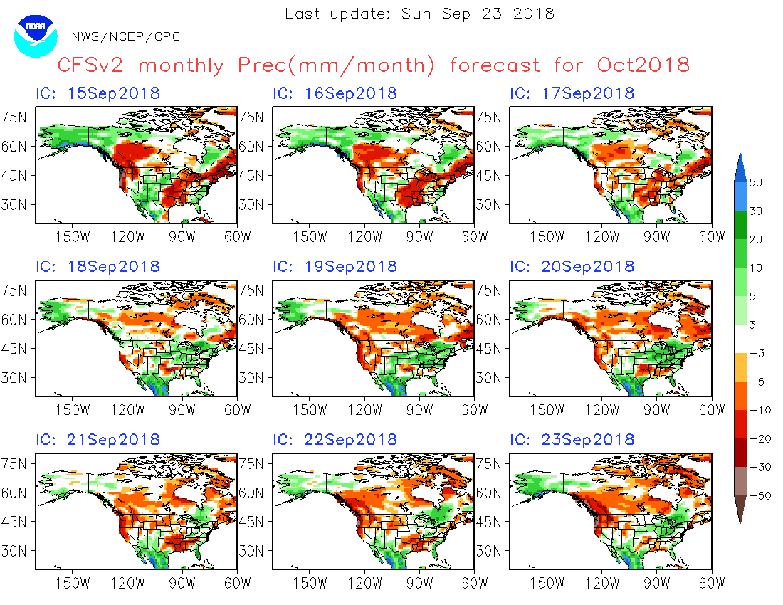
What once looked like a decently chilly start to October now looks like a continuation of late summer with highs back to near, or above, 80º across much of the Lower Lakes next week.
-
2
-
-
Well this is certainly a different look to October than what was shown at the beginning of the month!
-
3
-
-
You can tell how desperate we are for active weather when we're sharing historical and forecast data suggesting snow in September!

-
1
-
2
-
-
On 8/23/2018 at 12:08 PM, IWXwx said:
I feel the same way. However, how do you answer the public who wants winter season predictions? I know that you get that question because even in my position I get that a lot. I just answer what indices point to with a disclaimer that it is not my forecast. If you've seen my snowfall contest predictions for the past few years, you know that I don't have a clue. lol
Well, I do discuss teleconnections and give them my best educated guess, and management likes us to put together a forecast, but I'm also very transparent about taking long range forecasts with a grain of salt. Trends are easier to nail than specifics, and that's what we try to do. Then you have those viewers who cling to their farmer's almanacs and will let us know if we say anything contrary to that haha!
-
1
-
-
56 minutes ago, IWXwx said:
After all of the rah-rah hype preceding last winter, Nina blah blah... Pac Jet ...SOI....PDO blah blah blah and comparing it to my outcome, I'll just wait until Thanksgiving, thank you. Que sera, sera.
When I was younger I would get soooo excited for this time of year because it meant winter forecast speculation season! The older I get, however, the more I just tend to look at trends with some amusement and then sit back and watch whatever happens. Amazing how the stress levels go down. Nothing I can do to change the outcome anyway
")
-
2
-
-
5 hours ago, IWXwx said:
If I'm not mistaken, there wasn't a tornado warning on this storm which was only about 15 miles from radar.
PUBLIC INFORMATION STATEMENT
NATIONAL WEATHER SERVICE NORTHERN INDIANA
219 PM EDT TUE AUG 7 2018

...NWS DAMAGE SURVEY FOR AUGUST 6, 2018 TORNADO EVENT...

.WARSAW INDIANA TORNADO...

RATING:                 EF-1
ESTIMATED PEAK WIND:    90 MPH
PATH LENGTH /STATUTE/:  4.1 MILES
PATH WIDTH /MAXIMUM/:   50 YARDS
FATALITIES:             0
INJURIES:               0

START DATE: AUG 6 2018
START TIME: 827 PM EDT
START LOCATION: 1.1 MILE NORTHEAST DOWNTOWN WARSAW
START LAT/LON: 41.2449N / -85.8290W

END DATE:               AUG 6 2018
END TIME:               834 PM EDT
END LOCATION:           5.2 MILES EAST WARSAW
END_LAT/LON:            41.2404N / -85.7514W

SURVEY_SUMMARY: THE NATIONAL WEATHER SERVICE IN NORTHERN INDIANA
HAS CONFIRMED THAT A LOW END EF-1 TORNADO TOUCHED DOWN IN WARSAW
JUST SOUTHEAST OF PIKE LAKE AROUND 827 PM EDT AND THEN TRACKED
RAPIDLY EASTWARD, LIFTING AROUND 834 PM EDT 5.2 MILES EAST OF
DOWNTOWN WARSAW.

NUMEROUS TREES WERE DAMAGED INCLUDING UPROOTED TREES, SNAPPED
TRUNKS AND TOPPING. SEVERAL HOMES AND CARS WERE IMPACTED BY TREE
DEBRIS. IN ADDITION SEVERAL POWER POLES WERE SNAPPED. MINOR
ROOFING AND SIDING DAMAGE OCCURRED TO SOME HOMES AS WELL.

THE TORNADO OCCURRED ALONG THE NORTHERN EDGE OF A BROADER WIND DAMAGE
SWATH OF UP TO 250 YARDS. DAMAGE HERE WAS MUCH MORE SPORADIC WITH
ESTIMATED WINDS OF 60-65 MPH.
Correct, no tornado OR severe warning at the time.
In IWX's defense, I was live on FB at the time and had velocity up and winds could not have been more than 30 mph from my estimation. Just nothing spectacular about the radar signatures at all. This tornado report shocked me, tbh
-
3 hours ago, IWXwx said:
EM sending photo of a funnel cloud to IWX from a small storm with a very small tornado warning.
INC183-080100-
/O.CON.KIWX.TO.W.0007.000000T0000Z-180808T0100Z/
WHITLEY IN-
839 PM EDT TUE AUG 7 2018

...A TORNADO WARNING REMAINS IN EFFECT UNTIL 900 PM EDT FOR CENTRAL
WHITLEY COUNTY...

AT 837 PM EDT, A SEVERE THUNDERSTORM CAPABLE OF PRODUCING A TORNADO
WAS LOCATED 1 MILE NORTH OF COLUMBIA CITY, MOVING EAST AT 10 MPH.

HAZARD...TORNADO.

SOURCE...RADAR INDICATED ROTATION.

IMPACT...FLYING DEBRIS WILL BE DANGEROUS TO THOSE CAUGHT WITHOUT
         SHELTER. MOBILE HOMES WILL BE DAMAGED OR DESTROYED. DAMAGE
         TO ROOFS, WINDOWS, AND VEHICLES WILL OCCUR.  TREE DAMAGE IS
         LIKELY.

THIS TORNADIC THUNDERSTORM WILL REMAIN OVER MAINLY RURAL
AREAS OF CENTRAL WHITLEY COUNTY.
The photos they shared on their FB page (Whitley co EMA) is at odds with their report, however. Just lots and lots of scud. Had many photos/videos sent in to the newsroom, too. Again, scud for days.
At least there was something visual with the Whitley tor warning today. The Steuben one just simply didn't produce anything interesting. Not even a cool cloud formation!
-
1
-
-
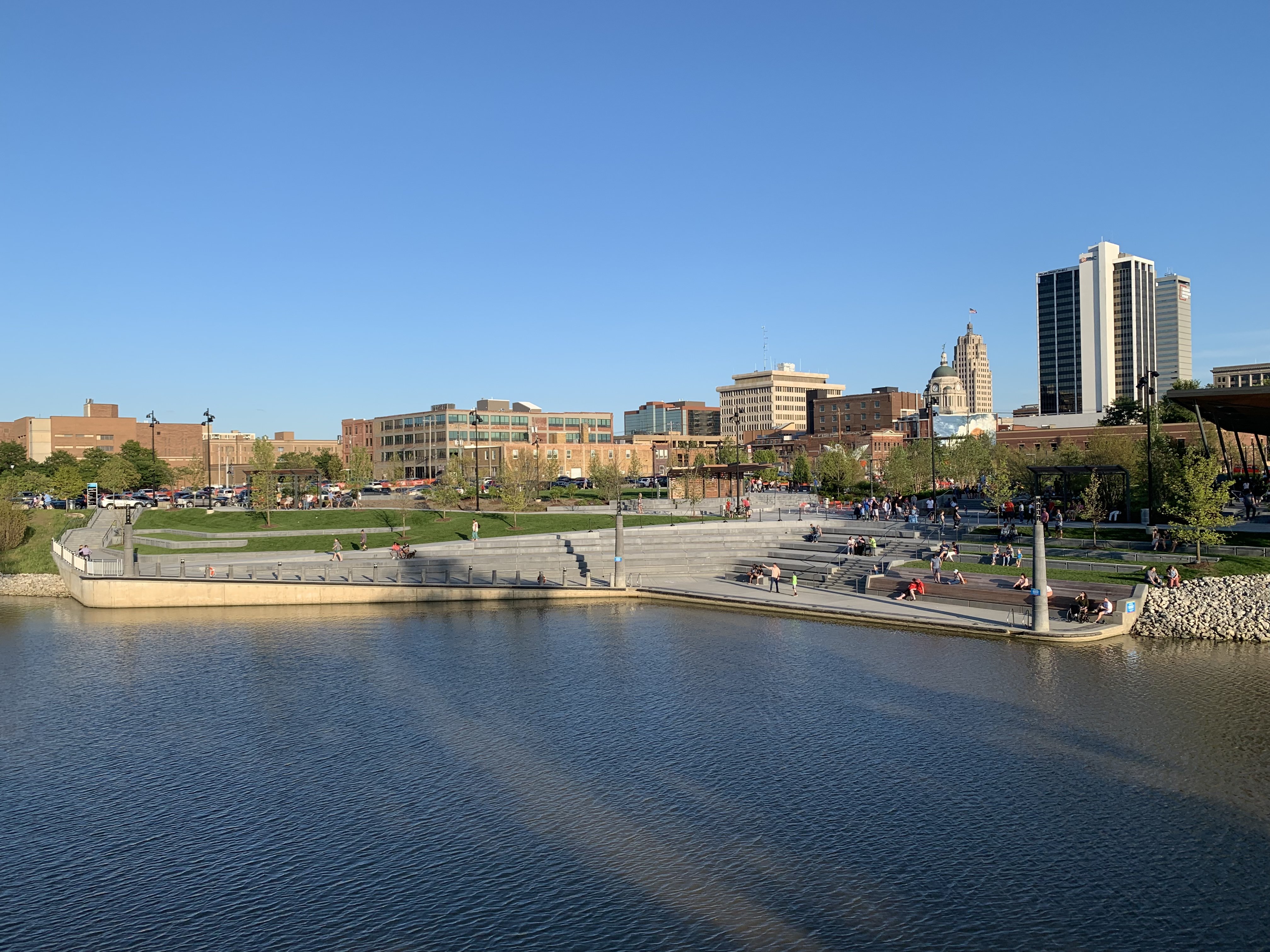
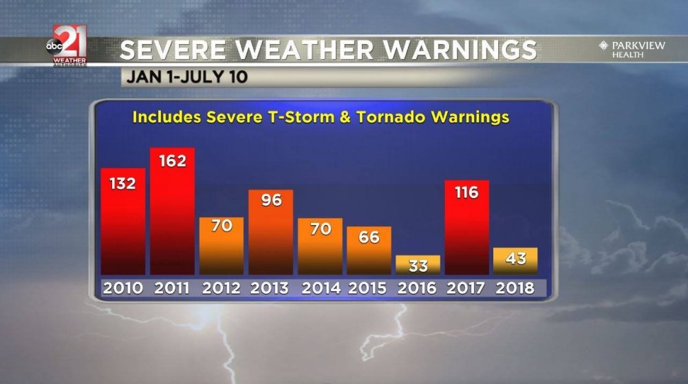
Amazingly quiet spring and summer to date in Fort Wayne. In fact, one of the quietest in Northern Indiana in 8 years at least. Looking at the long range, that trend looks to continue.
-
On 5/31/2018 at 10:14 PM, IWXwx said:
...and yet another t-storm warning for my county today with no severe weather, just a nice summer's night thunderstorm. At least my spotters weren't playing whack-a-mole like we did with the pulse storms this afternoon.
I'm thinking 4 warned storms in a 7 hour period with no severe has to be some kind of record.
Yeah, definitely a bizarre weather day. Received zero actual severe reports, as in measurements, but TONS of gorgeous photos. I mean, if the bulletins were reworded as Sexy Cloud Warnings or something, then I'd say their accuracy would be 110%!
-
2
-
-
2 hours ago, IWXwx said:
I hope you guys score. We have had four days of slight risk or better in 2018 in NE IN and have nothing to show for it. Three out of the four times, I questioned SPC for including our area when guidance didn't look great to begin with.
This has become increasingly frustrating from a media perspective. I've stopped using the terms "marginal," "slight," etc altogether because they don't mean much to a viewer to begin with, especially when we have numerous slight days with, as you said, nothing to show for it.
Looks like the next 7 days at least will be zzzzz. What an odd and eerily quiet spring it has been!
-
2
-
-
21 hours ago, Hoosier said:
Have been looking at some potential target locations in my favored zone (want to be as close to the center line as possible and not in the middle of nowhere, but not in a place with too many obstructions/artificial light). Seems like a lot of towns in the path are having special viewing areas and giving out tickets for that. How can you know exactly where you'll end up given potential weather issues?!
Exactly! I'm going down to Carbondale, IL, with a photographer to cover the event, but knowing my luck it won't be clear or super stormy...we'll be stuck under thick cloud over with light rain most of the day
 Hoping for the best!


Spring/Summer 2019 Complaint/Banter Thread
in Lakes/Ohio Valley
Posted
I grew up on the Kitsap Peninsula, just west of Seattle. All 18 years of my child/early adulthood! It rarely rains in the summer. We would get the occasional onshore flow bringing us clouds off the Pacific, and maybe a bit of drizzle, but there is sunshine galore from about May-October.
Not only does Fort Wayne (where I live now) get more annual rain than Seattle, it is far cloudier. Fall in Indiana, however, has proven to be the most reliable and pleasant of seasons. Lots of sun, stunning color, and an occasional severe threat to keep things interesting.