

Ravens94
-
Posts
1,475 -
Joined
-
Last visited
Content Type
Profiles
Blogs
Forums
American Weather
Media Demo
Store
Gallery
Posts posted by Ravens94
-
-
-
Heavier returns definitely forming along and west of 95 running NE
-
This screams overperformer North and NE of 70
-
 1
1
-
-
Special Weather Statement
Special Weather Statement National Weather Service State College PA 204 AM EST Sun Feb 13 2022 PAZ059-064>066-130800- Lancaster PA-York PA-Adams PA-Lebanon PA- 204 AM EST Sun Feb 13 2022 ...A BAND OF HEAVY SNOW WILL AFFECT PARTS OF LANCASTER...YORK... ADAMS...AND LEBANON COUNTIES... HAZARDS...A band of heavy snow which can rapidly reduce visibility to less than one half of a mile. Snowfall rates around one inch per hour. LOCATION AND MOVEMENT...At 203 AM EST, a band of heavy snow was along a line extending from near Myerstown to near Mount Joy to York to near Hanover and moving northeast at 5 MPH. LOCATIONS IMPACTED INCLUDE... York, Lebanon, Hanover, Weigelstown, Elizabethtown, Columbia, Lititz, Mount Joy, Parkville, Manheim, Myerstown, Shiloh, East York, Stonybrook-Wilshire, West York, Salunga-Landisville, Littlestown, Denver, Maytown and Codorus. * This includes the following Interstates... The Pennsylvania Turnpike from mile markers 259 to 282. Interstate 83 from mile markers 11 to 28. SAFETY INFO... Conditions can deteriorate rapidly in winter weather situations. Be prepared for snow or ice covered roads. Slow down and allow extra time to reach your destination. && LAT...LON 3972 7729 3997 7696 4017 7665 4017 7663 4019 7657 4022 7658 4042 7631 4027 7608 4019 7625 3972 7692 TIME...MOT...LOC 0703Z 239DEG 6KT 4034 7619 4019 7650 3998 7676 3973 7711 $$ -
Can confirm GFS is dead wrong with its forecast precip is no where to be seen where it had it
-
Really impressive jet clouds are moving incredibly fast on goes
-
Yellows firing west of DC moving up 95 dynamics are kicking in
-
1
-
-
-
Relatively stationary impressive

-
-
Honestly 0 vis on camera

-
Just now, gopper said:
Will they?
They will with time
-
1
-
-
Ripping in Frederick

-
1
-
-
Just now, jayyy said:
Bright yellows currently about 5-10 miles to my west. Patiently waiting. Impressive snow occurring regardless but come to papa
Traffic cam is impressive in the band
-
Can't wait for these to come east

-
1
-
-
Yellows rapidly expanding to the NW
-
1
-
-
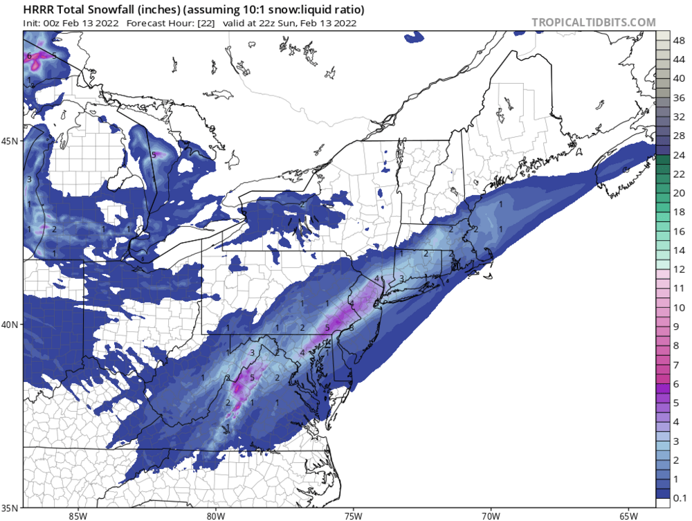
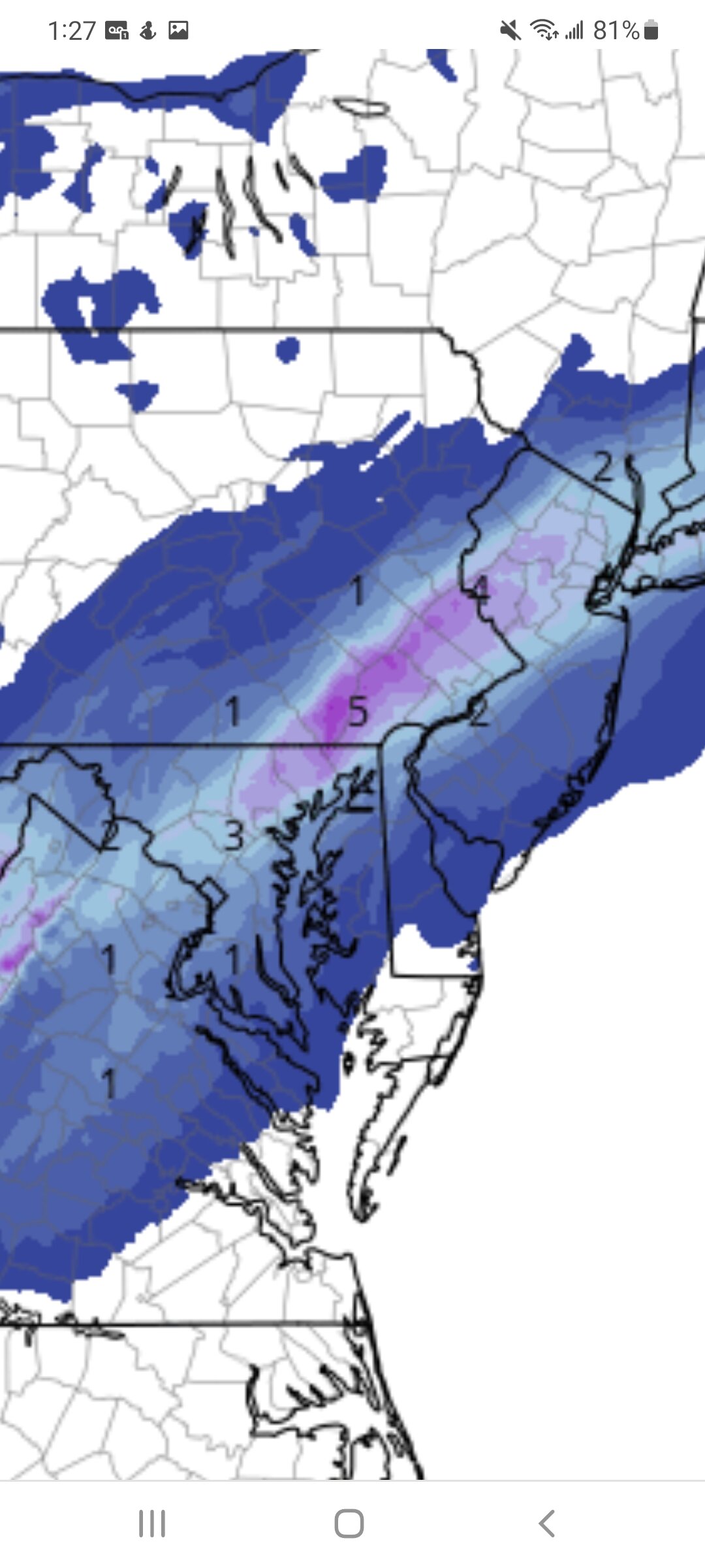
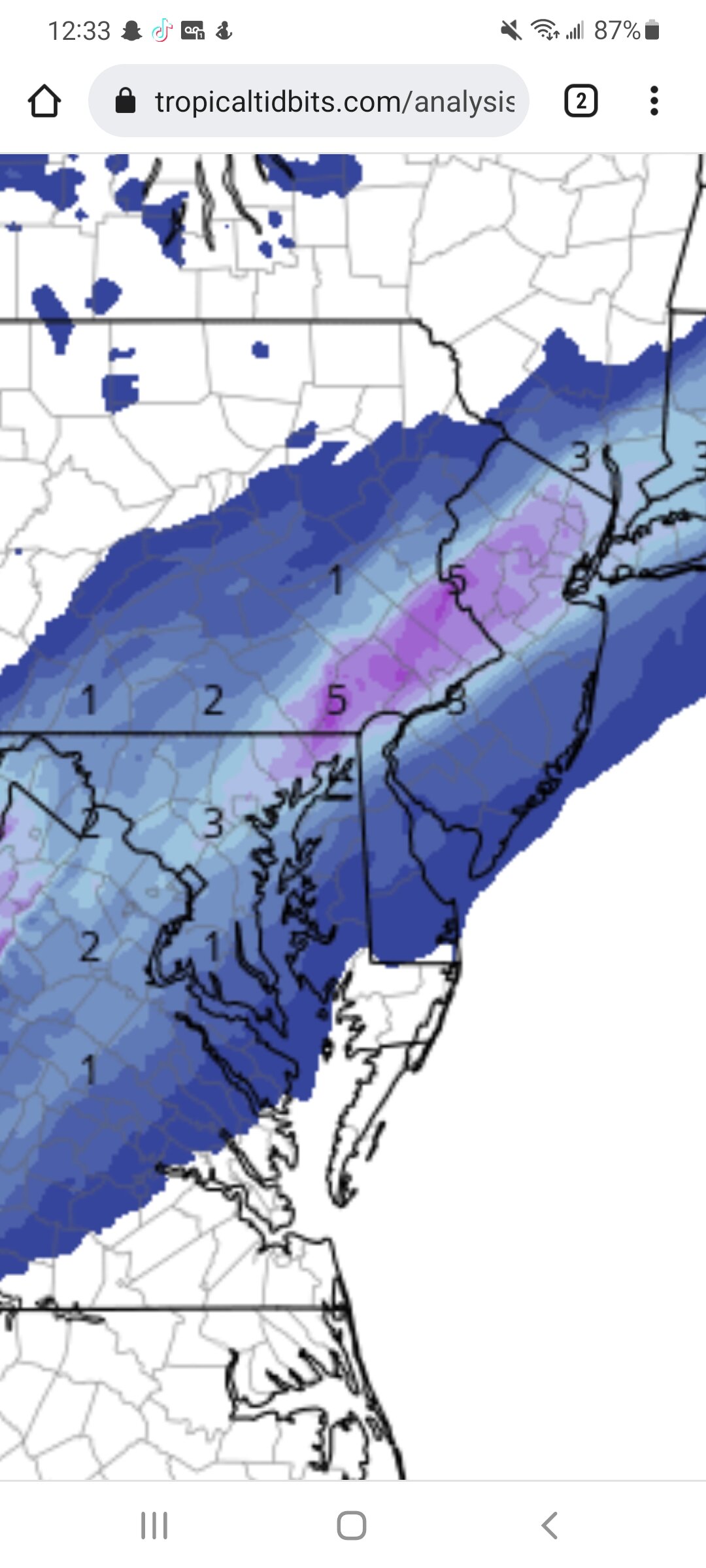
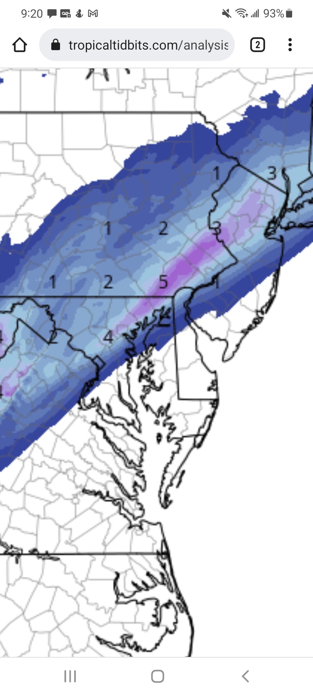
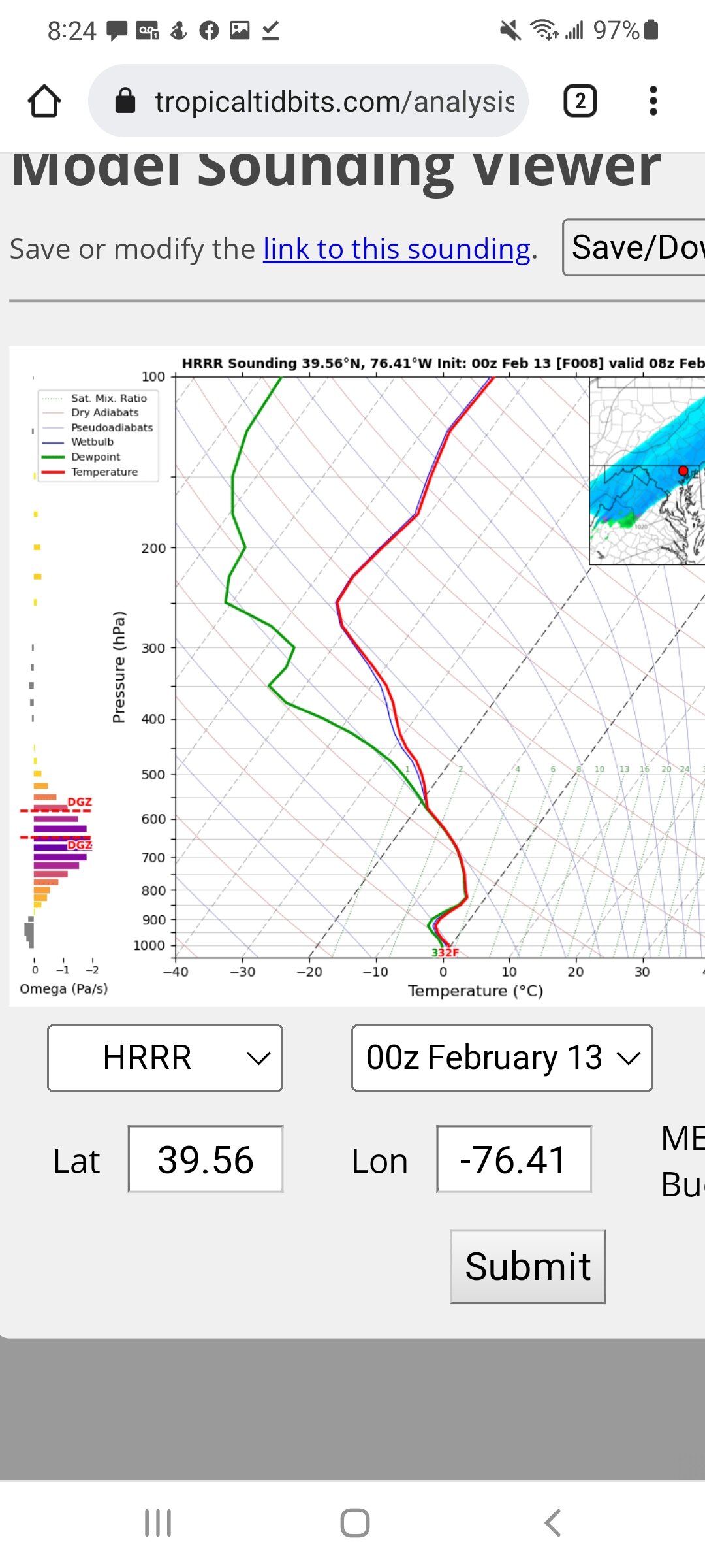
HRRR is not giving up on giving 4+ From Baltimore NE. Actually gives decent snow all day tomorrow

-
2
-
-
5 minutes ago, jayyy said:
Last few frames on the radar you can see the rain snow line getting battered between silver spring, Columbia, and west Baltimore. Temps dropping hard as heavier returns roll in. Impressive.
NAM doing a better job with this so far than the GFS. Heavy precip setting up shop right over Maryland and it nailed how far north snow would fallGfs is terrible not even close for sure
-
Temps are really tanking in Baltimore County NE widespread 33-35 degrees now

-
3
-
-
-
Snow in bel air
36.7 falling quick
-
Still coming down but HRRR is only improving on the band location

-
1
-
 1
1
-
-
-
NE MD semi pummeled
-
2
-


Feb 12/13 Event Quest for Blues to Envelop More Rather Than Less
in Mid Atlantic
Posted
Compared to obs NAM is way to warm it appears the HRRR is doing best right now