
Poimen
-
Posts
2,147 -
Joined
-
Last visited
Content Type
Profiles
Blogs
Forums
American Weather
Media Demo
Store
Gallery
Posts posted by Poimen
-
-
For what it's worth: the 9Z SREF run has a noticeable uptick in qpf for much of the area. In fact, the snow plumes for K.C. jumped to a mean of 5" at 9Z. The mean was 1.5" in the previous run. This should result in a noticeable uptick in qpf for the 12Z suite of NAMs. We'll see.
-
 1
1
-
-
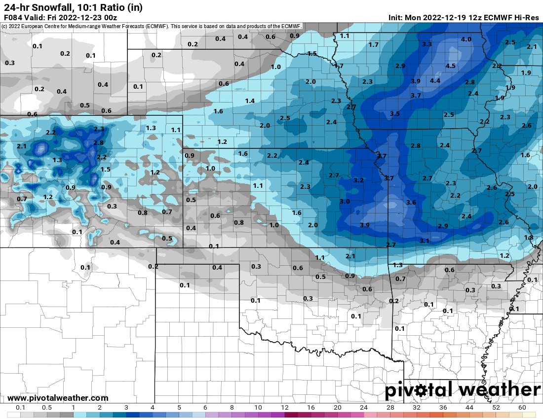
According to the afternoon AFD, the Topeka office is forecasting 20:1 ratios.
-
Here's the 10:1 snowfall output from the 12Z EC. These were higher than I thought it would be. I suppose we can expect ratios greater than 10:1--but I've lived my whole life in the south where 8:1 ratios are the going rate. I've never seen soundings like the one's I'm looking at now.

-
I've been loosely tracking the GFS Kuchera totals for my backyard. It just went from 17-20" in the prior runs to 5" on the 12Z. Don't get me wrong, I'd be happy with 5" of snow, but the trend this morning seems to be a quicker and less amped system for this area. Still plenty of time for things to change.
-
Hey guys. I recently relocated from North Carolina to the Northland of K.C. (MO). I'm looking forward to experiencing my first midwest winter storm (hopefully). Thanks for all the info here.
-
3
-
-
2 hours ago, mclean02 said:
Whew not sure if that has happened in Greensboro before 10 degrees and snowing ! lol

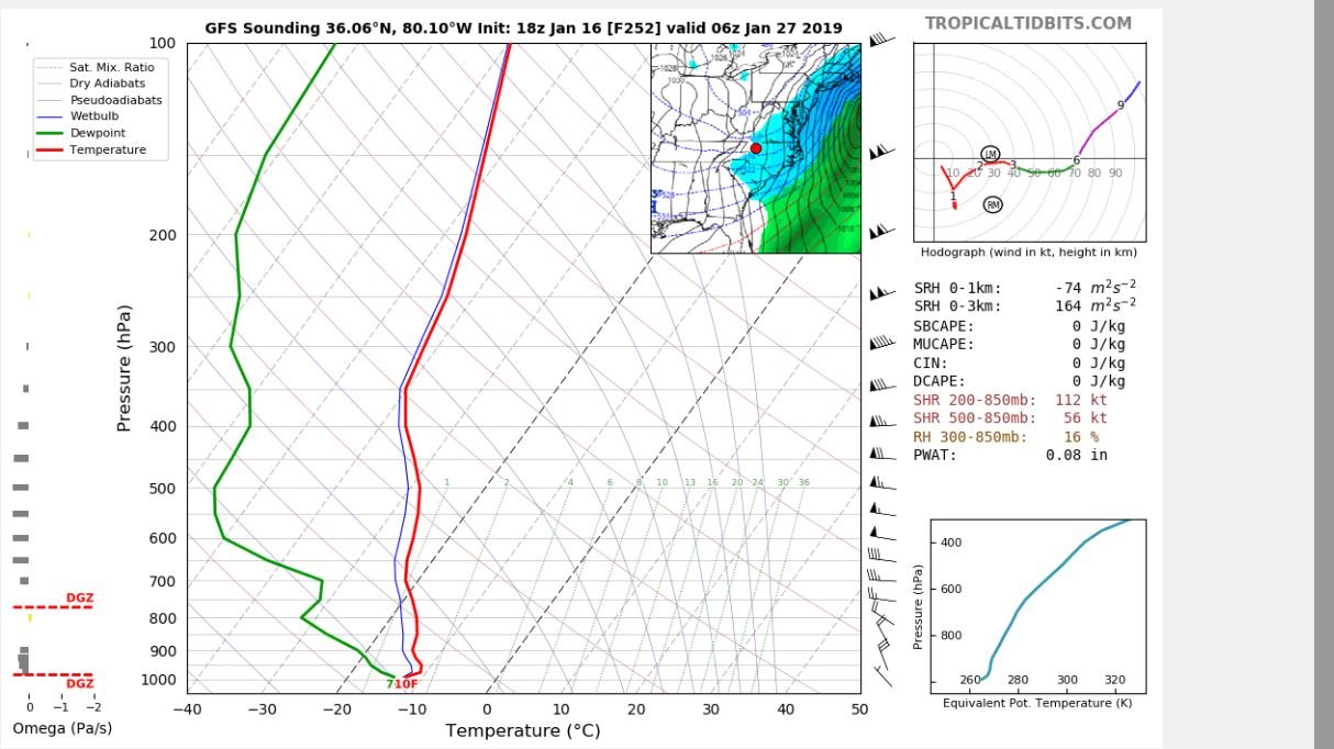
Keep in mind that the "precip" on the map is the accumulated precip during the previous 6 hours. That sounding is so dry that the only flakes flying will be the dandruff from my head.
") Probably whatever precip fell from the sky did so many hours before this sounding.
Probably whatever precip fell from the sky did so many hours before this sounding.
-
1
-
-
7 hours ago, jburns said:
I don't know about that. All my calendars still have January before February. Good luck though!
Your calendar may be good, but your eyes or reading comprehension may need to be checked, old-timer. It did say, "in reverse order." Good luck though!
-
Here's a comparison between the day 10 EC/FV 3. Both have a similar look with regards to the developing -AO/+PNA. This is very positive, in my opinion.


-
3
-
-
Yeah, it's in la-la land, but here's a look at the 12Z FV 3 near the end of the run. We're beginning to see this type of look more consistently in the longer range.

-
2
-
-
It's interesting to compare this year with last year. Last January we experienced record cold/snow in the first half of January, only to flip to extreme torch in February. This year is shaping up to do the same but in reverse order.
-
1
-
-
-
Much closer than day 16 is the day 10 EC, which has higher heights developing over AK and east of Greenland. So although it remains torchy down here the next two weeks; the pattern shift just may be on track.

-
1 hour ago, Orangeburgwx said:
Browns winning the Super Bowl this year is a higher possibility than that... Never trust Day 16...
I understand the sentiment but this is the precise evolution that the experts are predicting. At some point we’re going to need to see this look showing up consistently in the LR. Hopefully it starts now.
-
2
-
-
Here we go...this look over the top is what we're looking for in general to flip the pattern. Now, can we reel it in from 16 days?

-
Aside from looking/wishing for a pattern flip in the LR, the next item of interest may be the day 8-9 system showing up in the 0Z EC/6Z GFS. Both have a Miller B look with strong/cold HP in SE Canada. Probably doesn't mean much for this sub-forum, but something to keep our eye on, I suppose.
-
29 minutes ago, NCSNOW said:
Seeing some cracks in the torchfest wall. Ive said to hang tight till Jan 1st and the models want be so depressing anymore. Sticking to my guns and well see come Tuesday. Cant look anyworsebthanbthese past few days lol, so can only go up. Think our friend the NAO may come around to save the day. Biggest thing that needs to happen is get the MJO in to phase 7 and prefearbly 8. Just get it moving out ofbthe dumpster fire phases. Lets see ifbthese cracks, keep trending next few runs.
Well, HM seems to think a -NAO is coming, eventually:
-
1
-
 1
1
-
-
Yeah...the LR (7-15) days looks horrible on the modeling. By the end of the period there is no arctic air on this side of the globe.
-
I never thought I'd consider sowing fescue in late December, but it is tempting right now...
-
 1
1
-
-
Maybe a bit more than token flakes here for the mountains/foothills/NW Piedmont...but then again it's still 6 days out. Something to talk about, I guess.

-
3
-
-
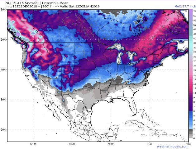
Next week doesn't interest me all that much. I'd say at best some of us might be able to see a brief period of wet snow--token flakes probably. But what lies beyond into the LR is intriguing, and perhaps we are just now beginning to see the effects of the SSW in that period. Day 10 EC puts part of the PV near Hudson Bay with higher pressure in the NW Territories. The 6Z GFS follows with this look at day 16. All of this to simply say that at the very least, the modeling is tracking in the overall direction of many of the winter outlooks that called for a back-loaded winter. Time will tell of course, but for now there is still plenty of reason to be optimistic.

-
Above normal in Alaska is the gift that keeps on giving.
-
-
Santa is bearing good gifts this year...even if they come after Christmas:
-
1
-
-
Plenty of reasons to be optimistic going forward: MJO; PV displacement/disruption; EURO weeklies showing blocky/cold pattern for January. Rest up boys and girls!!
-
2
-
1
-
MO/KS/AR/OK 2022-2023 Winter Discussion
in Central/Western States
Posted
Here are the last three runs of the SREF: