

Maxwell03
-
Posts
234 -
Joined
-
Last visited
Content Type
Profiles
Blogs
Forums
American Weather
Media Demo
Store
Gallery
Posts posted by Maxwell03
-
-
Happy Met Fall! My mood is high so long as it still feels like summer. Ended August with 4.44.
-
3 hours ago, StruThiO said:
Danielle set to become stronger than any system during 2013 and will contribute a decent bit of ACE.
The bar is on the floor.
-
 2
2
-
-
I am hesitant to speak in absolutes when the UTC calendar still says August, but it looks like a lock.
-
I don't believe what I'm seeing; it's actually raining a decent clip at my house.
-
On 8/24/2022 at 2:59 AM, BBasile said:
That is confirmed. It peaked at 83.8F last night.....which may be a new record? Primed for tropical season.
Oof, hope not.
-
0.36" in the gauge this morning. Once again, am underwhelmed. I didn't expect much, but I was still hoping for more.
-
Summer is back and I'm loving it.
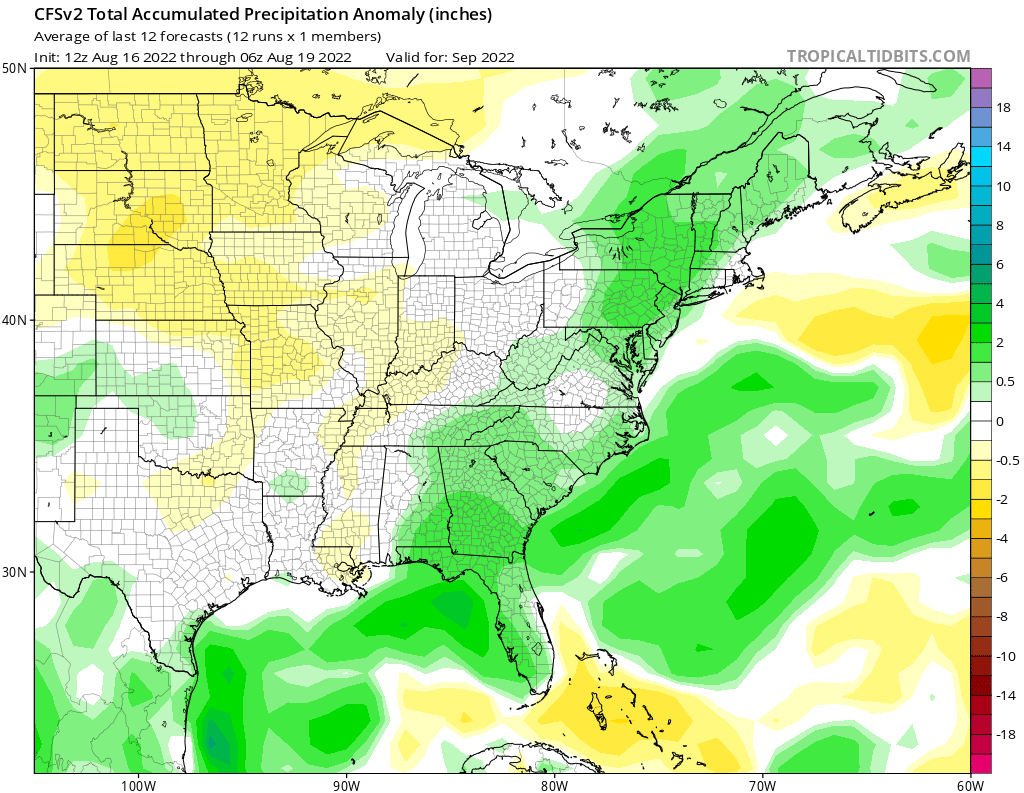
Still no rain since Aug 11. Here's to hoping the CFS Monthly for September has some weight to it; I'm tired of this dry pattern.

-
24 minutes ago, SnoSki14 said:
I mean though a quiet season would be extremely boring, it would be good for everyone dealing with high energy prices & inflation this year.
However I'm still waiting for August 20-22th. That's the period when the switch normally happens and you'd be surprised how quickly the tides can turn.
Not to mention the string of destructive canes that have rocked the US in recent years
-
 1
1
-
-
Choked right before it made it up here

-
 1
1
-
-
1 hour ago, JTA66 said:
Happy 8/2--a "cross quarter day", mid point of astronomical summer. Also on Friday 8/5, most of us max out our average daily high temps for the summer before we begin the slow descent and bottom out in early Feb. Just trying to find something/anything positive as we approach our next heatwave.
78F/DP 72F
Don't weekly average highs wane after mid July?
-
0.29" here this morning, was hoping for more
-
Looks like I will finish July with a paltry 2.45" in the gauge
-
Might be living in a satire at this point. 0.08" in the gauge this morning.
-
1
-
-
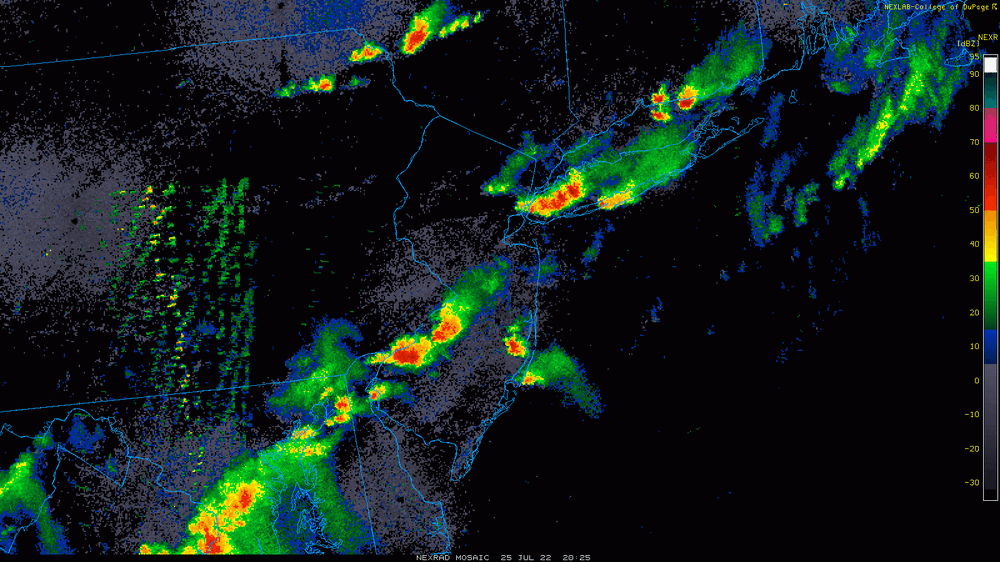
Tell me how the first severe warned cell in southern NJ went north of my house and now the second one is just south.

-
1
-
1
-
-
0.18" yesterday, primarily from a late night downpour. 1.47" for July thus far.
-
5 hours ago, RedSky said:
First cicada and a top 10 summer day
Absolutely buzzing in NJ
Stellar for July -- only 0.10" from yesterday's rain.
-
1.06" today from the afternoon line of thunderstorms and the popup that moved through Camden County earlier.
-
0.20" from this morning's storms.
-
I know there's an anti-summer bend here but I figured after today we should get this thread started.
-
1
-
 1
1
-
1
-
-
Received about an inch here before the changeover to freezing rain around 8. Driving conditions were treacherous but are likely ameliorating since we are above freezing. 36 now.
-
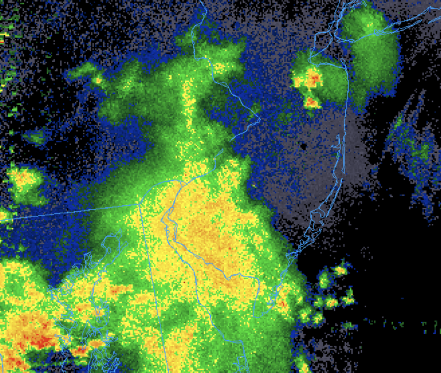
Nice cell just came through my neighborhood in SNJ. Sideways rain.
-
On 10/17/2021 at 9:56 PM, ncforecaster89 said:
Very true, Amped! Not since the 1993 season has there been no TS or H formations after September 30.
1994 for last “October” without a NATL basin TC.
I’d be very surprised if the season concludes without at least one additional TS. In contrast, I’ll be very surprised if the U.S. mainland experiences another hurricane landfall, however.
2006?
-
The course curriculum will not involve a ton of meteorology, but you can project meteorological data with GIS if you like. The NWS maintains a comprehensive dataset of GIS shape files that you can use to map warnings, storm reports, best tracks, etc. I have used the data in some of my class projects, which usually give you creative control. It's quite fun to manipulate if you ask me.
-
1
-
-
Crazy that we had this whole debate on how to retire Greek storms before having this backloaded Greek season


2022 Atlantic Hurricane season
in Tropical Headquarters
Posted
You must’ve glossed over Colin