

geddyweather
-
Posts
768 -
Joined
-
Last visited
Content Type
Profiles
Blogs
Forums
American Weather
Media Demo
Store
Gallery
Posts posted by geddyweather
-
-
969mb in Northern Indiana on the OP Euro makes me want to look up South Bend's record low MSLP...

-
5 minutes ago, andyhb said:
Subtle but notable.
EDIT: Yeah, big swing in member MSLPs...
-
IN/OH bros rejoice.
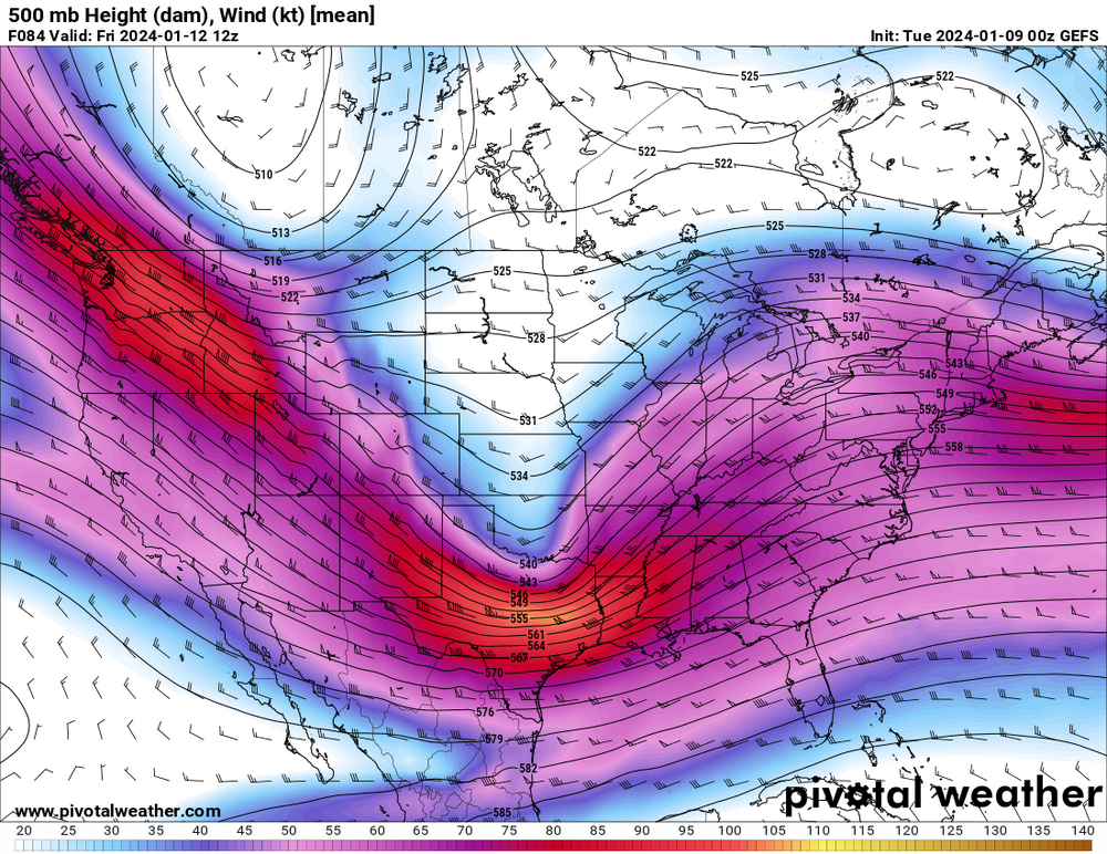
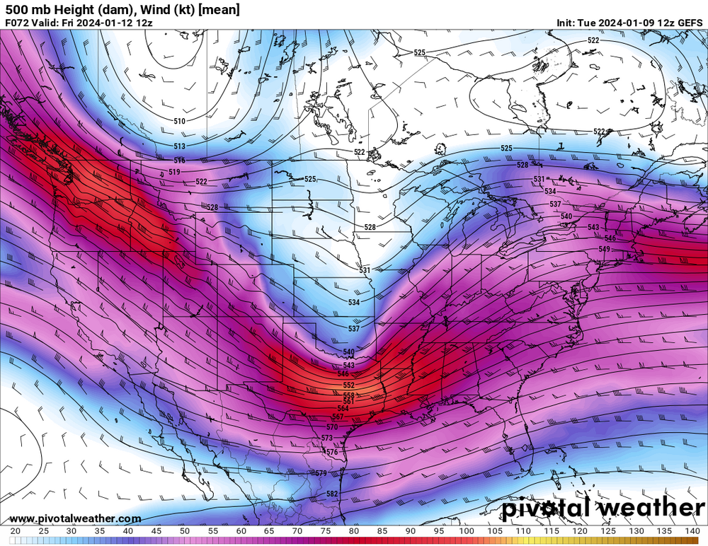
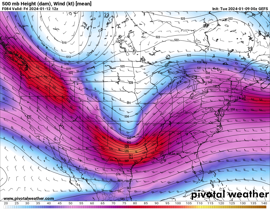
GFS, NAM, Canadian all have a bit flatter look in development like @andyhb mentioned, looks like due to a sharper Thursday wave and resulting response in ON from quick looks at 500mb on each. This still gets a relatively strong SLP into OH but much more progressive NE forward movement vs the bombing northerly cut. Solid totals across a lot of the forum but the brunt definitely settles into Nrn IN/NW OH/Srn MI.
-
 1
1
-
-
7 minutes ago, Stebo said:
Definitely don't like the Euro overamplified look, but I will say it was overamplified with the current system at this junction too. The GFS is probably a more reasonable solution just because the rarity of getting a low as strong as the Euro that far south and the GFS did pretty well with the current system where as a lot of other models had the low further north.
Been wondering this the whole time tbh. As much fun as it's been to watch, the climatology part of my brain has been rattling with the fact that it's just so unusual to see such an amplified system in that part of the region. Not saying it couldn't happen, but given the current background state (system today + disturbance Thursday + eastern ridging possibly playing a hand too) and past history, does it make sense?
-
1
-
-
Another wet one for the Ohio crew. Needs a reel east which isn't likely to happen under the current regime unless we get some help from the Thursday system or eastern blocking. Pain.
Scale of deepening on the GFS is incredible. 992 to 979mb in 6 hours in the MS Valley, not something you see everyday.
-
2
-
-
Goes sub-970 over Huron. Classic Great Lakes bomb. Curious about the precip wrap around into MI/IN/OH beyond hour 138 in that run, kinda looks like it is dealing with thermo issues? I would imagine under most cases that would all be snow...
-
1
-
 1
1
-
-
Might have to turn this into a late season SVR thread if the trend keeps up...

Seriously though. Went from snowmaker potential to nearly 60 degree dews getting advected in. Go figure.
-
1
-
-
7 minutes ago, Stevo6899 said:
I'm all for severe weather out in open fields in Iowa, but I'll never understand why people want severe weather in their backyards and homes. As far as today goes, front sped up, less time for atmosphere to get juiced for metro detroit. It's always something on this side of the state for storms lol.
Bingo. Wondered about this last night as storm motions in IA/IL reached 40-60mph compared to some of the CAM guidance.
Speaking of, after a relatively well forecasted 3/31 the models absolutely struggled with this. Different forcing mechanisms, speed uncertainty, and biases really seemed to wreck havoc with this.
-
4
-
-
15 minutes ago, hawkeye_wx said:
Hmmm..... The HRRR has mid 70s and storms forming east of Cedar Rapids. The 3k NAM has low 60s and storms forming near Des Moines.

Differences between these are too much to ignore tbh. Have to wonder if the HRRR is too juiced, though several other non-NAM CAMs and even the NBM seem to be leaning warmer with larger areas of 60+ dews.
-
Will this January have more meaningful cold-core tornado setups than meaningful winter storm setups for the subform? Discuss.

-
2
-
 1
1
-
 2
2
-
-
1 minute ago, weatherwiz said:
As we've seen the last several years there is not much you can do sometimes when it comes to intensity. Now model intensity guidance had been very aggressive in this becoming a category 4 hurricane but as we got closure there actually became a bit more in the way of spread regarding this and for good measures.
...
I wish I could scream this from the rooftops.
Plus, in regards to the ERC, there is so much uncertainty in regards to the efficiency and duration of this process that it could have had a number of different impacts on the storm. If the process takes a day or 2 complete vs just 12-18 hours, does it reach 155mph? If the eyewall never closes back up, does dry air + shear become a more prominent factor? What happens if the core doesn't double in size? How do any of these impact the system track? Etc etc etc...
The reality is we had a unique mixture of synoptic variables here compared to other Gulf storms which resulted in significant impacts to both track and intensity forecasts. As such the more moving pieces you inject into forecasts like this, the wider your envelope of outcome becomes even when in close range.
-
1
-
-
3 minutes ago, burrel2 said:
https://tidesandcurrents.noaa.gov/stationhome.html?id=8725520
6.82ft and rising.
that previous posted link of this station lags behind this one for some reason.
Better still. Thank you.
Already essentially at major stage. And high tide is two hours away. We may see some of the worst tonight in this area I'm afraid...
-
Just now, MattPetrulli said:
https://tidesandcurrents.noaa.gov/inundationdb/storm/Ian.html
Ft Myers at 5.31 and on a steep rise
This is what I have been looking for, thank you so much. Easy to confuse or lose resources on a day like this.
Yeah, so, already set a record level here and no sign of slowdown. I think it is safe to infer for those asking that surge flooding is in progress across Ft. Myers proper as well as much of Cape Coral. This will continue to rise over the next few hours. Bad bad situation.
-
41 minutes ago, MattPetrulli said:
4.38 ft is the highest crest ever on that. We may double that.
Last observed value at 3:36pm EDT was at 4.15 ft. Safe to assume that 50 minutes later, it has been broken. Not hard to imagine a very dangerous situation unfolding inland now...
Likely may be the hurricane doing this, but updates from here are very patchy. Is there a better way to see tidal gauges update than the AHPS site I linked to?
-
Fort Myers GoM Tidal Gauge starting to really climb now with storm surge. This is located well behind the barrier islands in downtown, just northeast of the Caloosahatchee Bridge.
https://water.weather.gov/ahps2/hydrograph.php?wfo=tbw&gage=fmrf1
-
3
-
-
Just now, beanskip said:
Link?
Lindgren & East Gulf west is the one I'm watching. White mailbox. Wasn't far up but post move fasts, apologies.
-
That Sanibel camera at Lindgren & East Gulf is horrifying. You could see the road when I started watching 10 minutes ago, now all submerged and rising fast.
-
 1
1
-
-
This board reaches its prime whenever someone points out a minor structural deficiency within 30nm of the eye.

-
1
-
-
It's probably been alluded to already but, though not as flashy as Tampa Bay, a storm surge into Port Charlotte or Ft. Myers would be incredibly dangerous. Slowly hitting that there is no "good" place for this to come ashore given the current trends.
-
May be some 500mb support on the way for that Indiana cluster. South side of a 40-60kt streak moving quickly into the region, some fast moving showers seem to be forming on the periphery.
-
2
-
-
Models are not going to be of much help, going the old fashioned way seems to be the play today. CAPE gradient already developing along the warm front which should continue to advect NE-ward as the afternoon goes on. Storms in southern MN slowly getting together on the flank of the seemingly stronger of the MCVs would be what I'd keep an eye on currently. Current mean winds suggest this initial activity turns to the SE as it moves into central WI. SPC seems to support this becoming the main show as this is around where the ENH corridor begins.
-
1
-
-
47 minutes ago, Jackstraw said:
The northern part of the front is painstakingly creeping E/SE. Ive flipped back and forth from rain, pingers and snow 3 times in the last hour.
This has sooooooo many poeple back home antsy and ready to throw in the towel. The pretty consistent stream of moisture back through IND and into the OH Valley + slow but steady SE movement + rapidly approaching sunset says otherwise though. Definitely will keep the 20-30" totals away but this whole corridor is still set for a good 8-12"/10-15" type storm imo.
-
1
-
-
2 minutes ago, Hoosier said:
Appears to be a ghost upgrade. There was no heads up and nobody knows who did it.
Not a fan so far.
BUT we have badges now! Was pleased to see I finally got one year in recognition after joining *checks notes* eight years ago...
-
3
-
-
8 minutes ago, sbnwx85 said:
Update from IWX. A couple hours old now but shows they’re confident storms will develop as the MCV approaches. It’s been warm and muggy with sunshine all day. The webinar indicates US 30 as the most likely area for tornadoes, but the location of the warm front depicted in the SPC MD would make me think the state line might be a better option?
Actually US 30 in western IN probably is a good call. Further east the risk shifts more so along/north US 24 which I figure is what you are alluding to.
Think SPC (plus IWX) are actually onto something here. Increasing bulk shear and a much more unstable environment are available especially in the central/eastern zones of the MCD should allow *something* to crank along that MCV. Feel that IWX's thinking of supercell to linear transition is probably the most accurate though this week has shown that if an established supercell or two can root themselves along the warm front, they can stay productive for a little longer before changing modes.
-
1
-
1/8-1/10 Potential Winter Storm
in Lakes/Ohio Valley
Posted
Believe 981.9mb at KIND will be a new minimum MSLP record for January, breaking 1978's record of 984.4