

ATLMet84
-
Posts
48 -
Joined
-
Last visited
Content Type
Profiles
Blogs
Forums
American Weather
Media Demo
Store
Gallery
Posts posted by ATLMet84
-
-
3 hours ago, SnowDawg said:
That's so wild. Got to 49 here today with full on sunshine.
So yesterday I was supposed to hit 41 and hit 33.9. Today I was supposed to hit about 51 and hit 42.3. Sun never really came out till briefly right at sunset. Wind stayed easterly albeit very light. Did the intense snow create some kind of a strong pseudo wedge that just didn't break down? Hmmm. BTW, all the snow had almost completely melted so I drove to Sawnee Mountain (1945') about 2 miles to my SE and there was still the slightest evidence of a snowstorm. Gotta love some elevation.
-
Lookout, I've been on these boards for years and always look forward to your contributions. Did you at least see anything accumulate? I read through these pages and don't see anything about you.
-
It was also amazing the temp difference in North GA today. While Gainesville only hit 33, my station only hit 33.9, Atlanta hit 45 and Peachtree City hit 49! Next issue is freezing fog. Can anyone that had accumulating snow see anything outside? The fog is as dense as I've ever seen it here. Temp is 31.2 and probably will end up in the upper 20s in the morning. Crazy weather (and I'm loving it!)
-
Well, this overperformed according to forecasts I would say. I got about 3-3.5" here on the NW side of Cumming. Beautiful snow day today. Only 33 now.
-
That is crazy. Goes from a warning in my county to nothing in south Fulton and Douglas. Just means I'll be smelling the rain all day here but hopefully will stay on the good side. It's only 28 here btw.
-
 2
2
-
-
44 minutes ago, NGTim said:
I really don’t know how to act. I seem to be in the bullseye in Lumpkin county
Happy. Can't beat being in the bullseye only 12 or so hours out. You're sitting pretty up there. 30.4 here
-
11 minutes ago, Extreme NEGA said:
00Z NAM gives us the goods

That shows me with about 3.5". I don't expect that but would love every second of it!
-
I'm down to 31.8 and hoping for greatness in the morning!
-
20 minutes ago, SharonA said:
You can click on the map below to get Lat/Long/Elevation, or key in a specific address:
https://elevation.maplogs.com/poi/cumming_ga_usa.62930.html
According to that I'm at 1214'. Nice to know. Knew I was somewhere around there.
-
5 minutes ago, Extreme NEGA said:
Looks good to me


I will be ecstatic if that kinda radar comes to fruition! Can you say huge wet flakes?! What time is that for?
-
5 minutes ago, mackerel_sky said:
It’s already 38 here! Winds ripping out of the w/sw, surprised we can get cold air with that trajectory
I'm on a ridge but already down to 32.6. Valleys are down below freezing with all night to drop as clouds have cleared. If winds die down, temps will drop well into the 20s. Temps can only recover so much from a cold night with clouds moving back in. Oh the hopes of snow for tomorrow morning. I'm giddy!

-
6 minutes ago, ST21 said:
I'm in Jackson county, GA, right on the edge of Hall county. Looks like I'm right on the edge of the heavier precip, hoping its more snow than rain
I'm keeping my fingers crossed for all of us in North GA. Hopefully you get accumulation too. Got any elevation over there?
-
12 minutes ago, SnowDawg said:
I definitely am. This is all I had hoped for out of February, just a well timed wave within a short window of cold temps. My house sits at around 2400. I think the counties to my SW (Lumpkin, Pickens, Dawson, etc) may end up doing a bit better just because of earlier onset and better orientation for upslope enhancement. But I'll be happy if I can get at least 2 inches. Still will be below seasonal average, but it sure helps take the sting out of it.
Well even if they get more to your SW along the higher ridgeline, you're still sitting VERY pretty up there with that much elevation. I'm only at 1200' down here so my "saving grace" will be early timing. I will be happy with a solid dusting. I'm sure due south of you in the lower elevations of Habersham Co. will have significantly lower totals and will melt early. Would be an interesting drive to see.
-
2 hours ago, Lookout said:
I dont agree with this. Temps should be at or even below freezing around Gainesville for a good portion of the event. Temps will already be 32 to 34 at onset with wetbulbs around 30 12z to 14z..and with steady precip temps wont move much.
Take it with a grain of salt but its Interesting to note the hrrr and 3km nam have narrow areas as high as 0.40 to 0.45 on the 18z runs. Would be something if that planned out.
I'm not sure if this will have eventual consequences in the morning but my temp never got above about 37 today with cloudy skies and right now at sunset it's starting to clear out and I'm down to 35. Maybe that will mean colder tonight as clouds move in and warm us up.
-
7 minutes ago, SnowDawg said:
GEFS has increased for like the 5th or 6th run in a row now.
If I were you(given how this winter has been), I would be like a kid in a candy store right now. You will most likely get plastered. What's your elevation up there?
-
42 minutes ago, burrel2 said:
Latest HRR at the end of its run, juicy...
 valid for 10am Saturday morning. Gainesville is gonna get plastered!

That has my entire county in yellows which I'm guessing is snow with more streaming in from the SW! IF something like that were to happen the dynamic cooling from the heavier snow would most certainly allow temps to drop to at least freezing. Soooo nice to look at but I'll take whatever I can get.
-
4 minutes ago, WarmNose said:
RAP doesn’t like this one for Upstate SC. So for that reason, I’m out
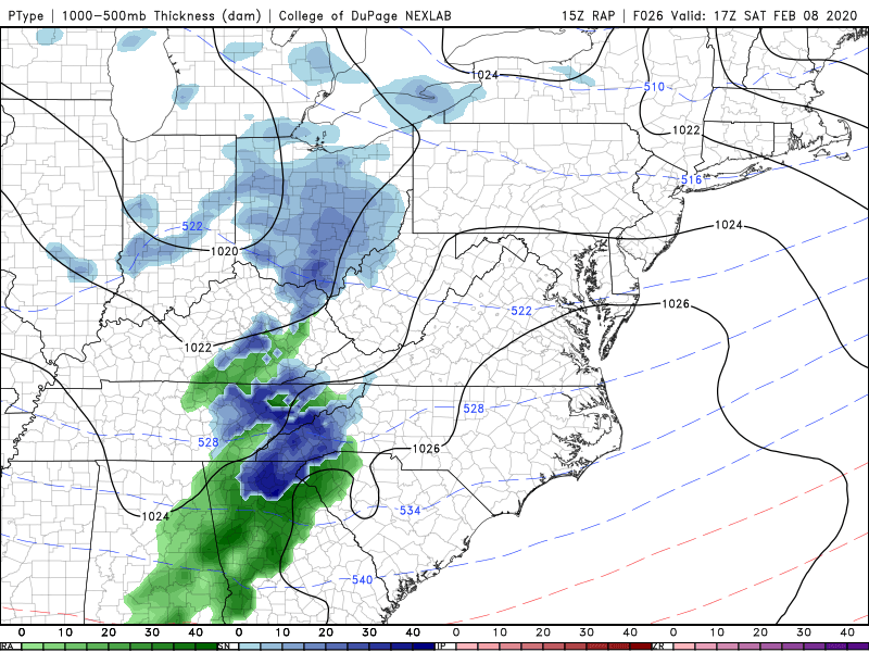
I know that's not exactly what will happen but that shows NE Forsyth County GA getting heavy snow with rain for me on the NW side. I'd cry....
-
1
-
-
3 hours ago, Lookout said:
Yep..its weird honestly how that is usually the case.
Models insist most of it is just north of here but I think its mostly snow as far south as here per soundings...assuming it doesnt arrive too late where surface temps are a problem. Hrrr as usual is too warm at the surface if there is as much precip as advertised. . Regardless it's close enough to drive too regardless. High resolution models showing some pretty decent returns on composite imagery some decent rates arent out of the question. Other than the mountains atlanta to Gainesville could be the winner as it arrives early enough for temps to be near freezing.
Could just the nam naming us but the 12z 12 and 3km run showing up to 0.30 liquid now.
Well this is getting me excited then. What do you think about my area in NW Forsyth? I suppose it's mainly a timing thing (and enough precip), but if we get enough precip early enough, inch or so maybe?
-
Given no more rain falls, my total from this system will be an impressive 5.65". They said 2-4" with locally up to 6". I never seem to end up in the "locally" total area. If it's not gonna snow this winter, at least I'm "winning" on the rain side.
-
50 minutes ago, Lookout said:
4.25 of rain so far. Dont remember the last time I've seen gsp and ffc issue so many flash flood warnings.
At one point the entire North GA counties were all under flood warnings. I don't believe I've ever seen that. FFC radar estimates look pretty close to reality; it shows a small pocket of 5-6" about half a mile to my west and my cocorahs guage recorded 5.65" in NW Forsyth. This means in 2020 (37 days) I've received a whopping 13.22"!.
2/8/2020 Snow Event
in Southeastern States
Posted
Well for some this turned into a major snowstorm (including for me, by southern standards of course). But yes, we are all snow hungry.