
BK Rambler
-
Posts
58 -
Joined
-
Last visited
Content Type
Profiles
Blogs
Forums
American Weather
Media Demo
Store
Gallery
Posts posted by BK Rambler
-
-
14th straight day of 90+ at my house and while some other areas around town have had a good shower or two over the past two weeks I've only registered 0.19" of rain during that time. Low this morning was 75 - yech.
-
3.15" of rain so far today in Roswell, GA
-
KATL finished Feb +7.6° over the 141 year historical average and the month ranks #7 warmest all time. The last three Februarys have ranked #2, #1, #7. The DJF season was +4.6°, 11th warmest. Not even a trace of snow was recorded for DJF 2018-19, only the 4th such season since 1928-29 and the first since 1949-50. At 22.20" it was the 8th wettest.
-
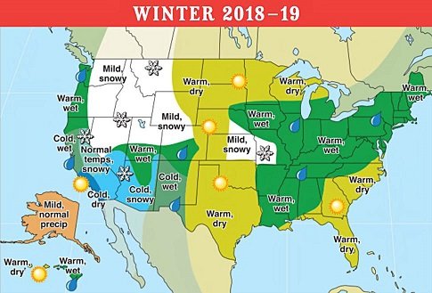
1 hour ago, Cold Rain said:1 hour ago, Cold Rain said:
Hahaha an area of mild and snowy surrounded in all sides by warm and wet or warm and dry. Lol
Yes it's a ridiculous looking map and I too laughed at the mild and snowy spot near Kansas City but ... here are some stats so far:
MSP Dec-Jan temps +2.4; Dec-Jan precip -15% (warm is a relative number in MN!)
KCI Dec-Jan temps +1.3; season-to-date snowfall 17" - seasonal average is 19" with Feb, March and even April to go for them
-
 1
1
-
-
2 hours ago, Lookout said:
"I just can't get over how horrible the winter outlooks have been. Normally when they bust they don't bother me because as i said the other day i never put any stock in them but this year it's really bugged me for some reason. "
Maybe because there was such a consensus for a cold and stormy winter in the South and East from so many that we respect and we got teased by the cold November and the early December big dog in NC. A lot of people scoff at the Old Farmers Almanac but they've done better than most for this season - no disrespect to the bustees - it's definitely an art more than a science still.
-
1
-
-
Topped out at 80° today - not only shattering the daily record of 72° at KATL but also now the new earliest 80° recorded.
-
 1
1
-
-
Finally dipped into the teens - low of 19° this morning. Might be the bottom for this so far lousy season.
-
Still 52° here in north Atlanta suburbia - gonna need a big crash in temps between now and the morning.
-
 1
1
-
-
For ATL area the 06Z NAM as well as the 3k NAM were bone dry for snow accumulations, the latest 12Z runs show some accumulation with the NAM a lot more aggressive (1-2" in metro) than the 3k (+ 1/2"). Kuchera ratios on all models are lower than 10:1 and must be considering a good bit of rain mix.
-
Bright clear skies and 27° - perfect viewing conditions for the lunar eclipse.
-
1
-
-
Today is the first below average day since 12/24/18 - 16 days - averaged +10° during that time - ugh.
-
Finished 2018 with 65.76" total precip. 13.74" fell in December!
-
Mine:
Highest Temp: 96 (6/15/, 7/11, 9/14)
Lowest Temp: 12 (1/2)
Highest Dew Point: 82 (7/11)
Lowest Dew Point: -3 (1/6)
Rainfall: 65.76"
Snowfall: 1.3" (1/16 - 17)
-
2 hours ago, NavarreDon said:
Did any of you feel this? Around 4:15 am EST.
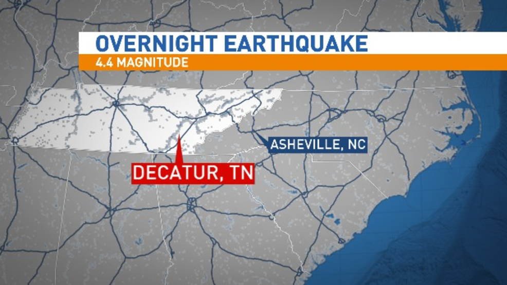
Woke us up - whole house was rattling - and we're in the north suburbs of Atlanta.
-
1
-
-
Finished November with 9.11" of rain (Roswell, GA) - December starting out waterlogged too. Temps averaged 47.9 (-4.8 versus KPDK climo) - just slightly above February's average.
-
Roswell, GA since Monday 5.03" of rain total - 8.50" for the month so far - glad the second half of November is looking drier.
-
Fire hose has been on around the ATL - 3.20" at the house so far today.
-
29 minutes ago, Powerball said:
What were the winters of 1921-1922 and 1925-1926 like?
They seem to be the common denominatord with all of these records being broken.
For ATL 21-22 was warm Dec, avg Jan, warm Feb and avg Mar; 25-26 was a bookend with cold Dec and Mar with normal Jan - Feb. Unfortunately my records database for snowfall in ATL only goes back to 1928.
-
KATL closed out with the second warmest September on record with an average temp of 81 (+7.5) - only 1925 was warmer. The lowest it got this month was 69! Here in the northern suburbs the lowest it got was 65. Only 1.30" of rain too.
Some other cities for Sept 2018:
AVL; - warmest on record
CAE - second warmest (1925)
GSP - second warmest (1925)
CLT - third warmest (1925, 1921)
RDU - fourth warmest (1921, 1933, 2010)
GSO - fourth warmest (1921, 1925, 2016)
-
2
-
-
18Z GFS keeps a huge 588+ ridge parked over us for nearly the entire run - sometimes stretches from Cabo San Lucas to Bermuda

-
 1
1
-
-
8 hours ago, Iceagewhereartthou said:
Very interesting data, thanks for posting. I'm actually shocked GMU made it all the way to 10/13 without a sub 60 in 2005. You are correct that GSP had a 59 back in August, and many outlying areas went lower and had more than one night. I had 2 or 3 mornings below 60 with the lowest 54 here in Easley, the only brush of fall so far! But this is just craziness. Has AVL ever had a Sept that never got below 60? I would be beyond shocked.
This September would be the first. I see the weekend morning forecasts are for right at 60.
-
8 hours ago, DopplerWx said:
he meant for the month of september. sorry i meant to say no temps below 60 for the month of sept.
Thanks for clarifying! Just looking back at CLT's September records there are four other years earlier than 1933 where the monthly min was 60 or greater.
-
Latest dates for first <60 temp:
ATL 10/8 (1911, 1925) only five years in total occurring in October - ATL has yet to reach 60 this year
CLT 10/5 (1881) only three years total occurring in October - note CLT hit 54 on 8/24 this year so curious about Brad P's statement
Greenville, SC (not GSP) 10/13 (2005) only instance in October (note GVL was 61 and GSP was 59 the morning of 8/24 this year)
Raleigh (not RDU) 9/25 (1906) - note Raleigh was in the fifties 8/24 & 25 this year
-
Tweet from Joe Bastardi a short while ago:
"new daily update is on, not behind paywall scroll down, No change to 1 week idea up till Cape Fear but after that Have made a change to end game. Lets see if its the only one Believe the new ridge will force this southwest and euro will win"
Joe Bastardi (@BigJoeBastardi) September 12, 2018
August 2019 Obs
in Southeastern States
Posted
Topped out at 99 today - hopefully the max for the year.