

Blizzwalker
-
Posts
76 -
Joined
-
Last visited
Content Type
Profiles
Blogs
Forums
American Weather
Media Demo
Store
Gallery
Posts posted by Blizzwalker
-
-
5 hours ago, North and West said:
This seems like an idea that will have wildly invariable and not-at-all-thought-out consequences. This is how snowpiercer happened.
.Forgot about Snowpiercer. I Think a lot of people on this board would love a train thru perpetual snow. Might get a whale of a Greenland block by dimming the sun ! But what happens to the MJO ??
-
Below is interesting article on feasibility of deliberately spreading particles in the stratosphere to stop global warming.
I am not an advocate of this idea, but do think it noteworthy that it's being reluctantly considered. Maybe this should be in climate thread, but I wanted to share in the sub-forum I am familiar with.
Dimming the Sun to Cool the Planet Is a Desperate Idea, Yet We're Inching Toward It. The scientists who study solar geoengineering don’t want anyone to try it. But climate inaction is making it more likely.
-
 1
1
-
-
8 hours ago, LibertyBell said:
What time did you take this-- the angle of sunlight is just about perfect.
Around 5 PM. Every year I get "saturated"with taking so many leaf pix, and every year I find myself doing it again. Kind of an Autumn addiction.
-
 1
1
-
-

some foliage at the Bashakill nature preserve near Middletown
-
7
-
1
-
-
1 hour ago, IrishRob17 said:
A major brush fire started yesterday and is on going today up near Sams Point.
Not happy to hear this. I'm going hiking near there today on the ridge north of Wurtsboro. I'll keep a lookout for smoke...
-
11 minutes ago, snowman19 said:
Funny how you’re spiking the football already, 24 hours out, it’s going to be funny tomorrow when you get less than an inch to total in NYC lol Watch the models back way off at 0Z tonight. The RGEM and CMC are the closest to reality IMO
There is empirical prediction...Then there is wishcasting.
Wishcasting goes both ways...
We should recognize it in ourselves-if we're going to call it out in others...
-
5
-
1
-
-
NOAA at 315 PM reduced my winter storm watch for Middletown (Orange Co) from 4-8 to 3-6. This, when globals and some mesos have increased snow amounts. Are they weighting NAM and some other mesos more?
-
1 hour ago, snowman19 said:
The Euro completely torches the midlevels before the precip even starts
Does it torch ? Does it thermally exceed all expectations -- and dash our hopes ??
-
 1
1
-
-
22 minutes ago, crossbowftw3 said:
It absolutely refuses to drop below 32F at 32/29, still no visible icing that I can spot.
Interesting to me that u have little ice in Sullivan while just west of Middletown we have what looks like .25. U mentioned it may be elevation dependent. I am at 700 ft-- only expect a 1-2 degree lower temp from your elevation. Maybe some other variables also contributing to this difference ??
-
Very light steady snow just W of Middletown.
-
1
-
-
Snowing very light but steady just west of Middletown.
-
11 minutes ago, CPcantmeasuresnow said:
Well I know you must be kidding because yesterday snowman19 guaranteed a torch beginning February 1, like has never been seen before and it would last through March and pretty much wipe out the rest of winter. It's not like him to make predictions like that unless they're a sure thing.
I actually took out all my spring clothes last night even though it's going to -5° here tomorrow morning. Other than his call in December for a torch in January and the virtual end of winter he's never steered me wrong.
Cautious descriptions of a trend are always informative. Terms like "mega-torch, torch on steroids, and thermal cataclysm" not so helpful.
They seem to imply a need to see extreme condtions that would disappoint others expectations...
-
2
-
 1
1
-
-
20 minutes ago, snowman19 said:
The ship has sailed on a snowstorm for the metro area. The fat lady is signing
Is she hard of hearing ?
-
1
-
2
-
-
59 minutes ago, snywx said:
Very nice! I believe the elevation up there is 2000’+
Yeah it's about 2300 ft. I said Sullivan but it's actually Ulster co. Always looks more wintry than I expect.
-
2nd ice pix..
1-10-22two.thumb.jpg.653dcdb76295b19f91e5377487c1f986.jpg)
-
5
-
-
An ice picture
1-10-22TWO.thumb.jpg.18c5bd89ed9c4dcbf8ecccdbbe1897ba.jpg) I took on Jan 10. Went up on Sams Point near Ellenville in Sullivan Co.
I took on Jan 10. Went up on Sams Point near Ellenville in Sullivan Co.
0 wind chill. ( I'm always the first person to show disdain at windchill numbers thrown around in the media. OK, it was about 14, but 0 sounds better...)
-
5
-
-
Some mood (disorder) flakes near Middletown.
Confusing diagnosis with December outlook, I guess...
-
1
-
-
Moon over Ashokan reservoir in Catskills last month. Something to look at while we wait for NAO, PDO, PNA, AO, EPO to favorably align...oh, I forgot the strat warming and gravity wave that might save us in February. Trying to be hopeful...
11-6-21.thumb.jpg.34f57ac5af78f3dae00e8d7996c481d8.jpg)
-
4
-
-
Looking on the NW thread but few comments about svr storms. Just w of Middletown have been rocked by lots of lightening and some winds past 50. Surprised I still have power. First gusts knocked my 2 mandevillas off my back deck.
-
6 hours ago, Poker2015 said:
Anyone know why storms usually split right around the Delaware River in Hunterdon County or just east into NJ? We got nothing last night and the storms did their typical split to the north and south of us.
I've heard Round Valley does something to the storms, but just looking for any explanation. Its just weird and happens alot.
I've wondered this too around Middletown, NY. We DID get reasonably well hit from convection line last nite with lots of lightening, but in watching radar intently over multiple summers, seems like there is some topographic feature that causes storms to "split" in Eastern PA as they are approaching western Orange county....looks like a decent line, then north and south (by 20 miles or so) get hit and we get an impoverished bit of rain and distant thunder. Seems it happens with non-noreaster snowstorms also. Maybe I'm just a frustrated wishcaster with too small a sample size.
-
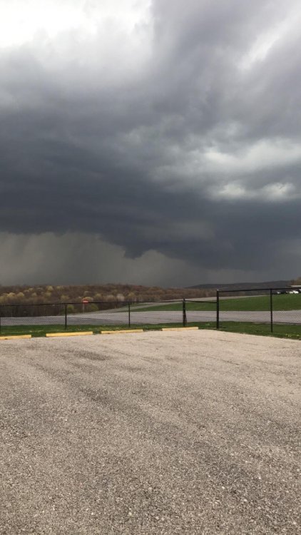
Using word "tornadic" to mean "tornado like", or "pertaining to tornadoes".
Perhaps I should have indicated that the protruding section of cloud in the image appeared capable of developing into a true tornado....seems like a semantic storm in a teacup...
-
I defer to severe WX experts...
-
Taken by my son around 2 PM today at airport where he works in Lagrangeville NY. Looks tornadic...
-
1
-
-
Are there microclimatological factors contributing to snow depth variation that go unaccounted for ? Sure.
Are there differences in measuring techniques/instrumentation that lead to inaccuracy in snow depth measurement? Certainly.
Do we have members whose self-esteem is so interwoven with snow depth that they would lie ? Unlikely....
-
4
-
1-10-22two.jpg.42545131eaf75193ee171488d9a9fc2d.jpg)
1-10-22TWO.jpg.7bee416deae39067fba2b110532f5891.jpg)
11-6-21.jpg.fb779f6e6f9717419c58b26855275085.jpg)

12/15 - 12/16 Coastal/Winter Storm & Observations
in New York City Metro
Posted
What happened to the NAM's seeing the warm layer for the 84 corridor and points south ?
I know that 10:1 maps are giving inflated numbers on the southern edge, given this setup, but same models were predicting much less in Orange co several runs ago. As others have mentioned,there seems to be a modest trend.